Union Pacific Railroad Trail Photos


You might also consider
More like Union Pacific Railroad Trail
Recommended Reviews - Union Pacific Railroad Trail
Start your review...

Reviews With Photos

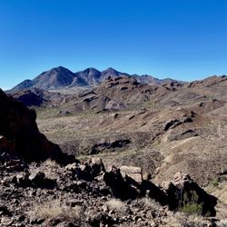
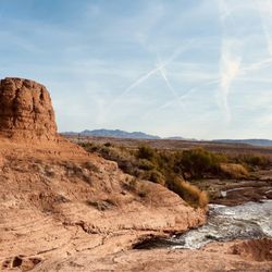
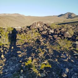
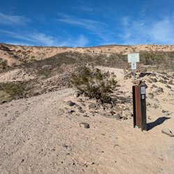
There are many trail systems around Henderson. The Union Pacific Railroad Trail is a very nice for bikers, runners, walkers and of course fur babies. It follows along side I-215 going east and then running along the tracks. It is widely paved with sporadic lighting along the way. For our doggie friends, there are waste cans and bags available in various spots. Part of the trail that we used, we weren't treated to much shade. During the summer months it could be pretty brutal. Id probably only recommend it when it cools down a bit. Happy Trails To You!
")
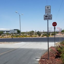
Road Cyclists perspective - this is my staple cycling trail as a South Central Henderson resident. Positive - Fairly level, just a slight incline heading East and decline heading west makes it a good trail for a recovery ride day or beginner riders. - Well maintained, paved and tiled trail - Easily visible signs placed along the trail at roadway crossings to indicate location of trail continuation to prevent confusion - Lighting that automatically brightens when one is under it runs the entire length of the trail. - Crosswalk lights that favor pedestrians and cyclists at all but 2 of the roadway crossing locations (locations without pedestrian lights listed in negatives) o Crossings with Pedestrian lights at Pacific Ave, Greenway Rd., College Dr., and E Horizon Dr., and Nevada St. Dr., and E. Paradise Hills Dr. - Connects to Acacia Park at Western end for those who would like to relax following their ride - At the Eastward end, the trailhead is close to River Mountain Loop Trail, where you can continue your cycling journey. Negatives - Have to cross the roadway (Running West from Acacia Park to East) at Fiesta Henderson Blvd, Pacific Ave, Greenway Rd., College Dr., E. Horizon Dr., Arrowhead Trail Road, Nevada St. Dr., and E Paradise Hills Dr. - At Fiesta Henderson Blvd and Arrowhead Trail Road, there is no pedestrian and cyclist crossing light to press to alert motorists - Have to cross the railroad next to Fiesta Henderson Blvd and Arrowhead Trail Road, so if a train is going by, you will have to wait for it to pass. - The flashing pedestrian/cyclist crossing sign buttons are often placed outside of pavement range, outside of the range of ramps connecting the road to the trail, or are at an odd angle to the road and the ramp. Thus, road cyclists often have to dismount their bicycle to press the buttons. - From a cyclists perspective, this is a shared trail with pedestrians that often do not understand cyclist instruction on direction to move to allow safe passing of cyclist, so you will have to slow down when coming upon pedestrians Further Info 1) Parking and restrooms for the Union Pacific Railroad Trail are available at Acacia Park (50 Casa Del Fuego Street). Additional parking can be found in dedicated lots where the trail crosses Fiesta Henderson Boulevard, Greenway Road, Arrowhead Trail and Nevada State Drive. (additional information at https://www.traillink.com/trail/union-pacific-railroad-trail) 2) The future plan for the paved trail is to continue northwest past 215. Construction was approved in Feb. 2017, construction is intended to begin at the end of 2017/early 2018 and will have a projected completion time of 1 year. North Union Pacific Railroad trail will be about 6 miles long, making the entire north and south trail length around 12 miles, great for beginner riders still looking for a ride of good length. (Source: https://www.reviewjournal.com/local/henderson/henderson-city-council-oks-30-5m-grant-for-union-pacific-railroad-trail-project) 3) If heading east on the trail (as I ride it), after E Paradise Hills drive the trail becomes gravel and about 0.1 or 0.2 miles down the gravel trail is the actual Trailhead (the trail runs East to West). To reach the next paved trail, turn LEFT onto E Paradise Hills Dr. and follow it until it intersects with Old Vegas Trail road. Here, you will reach a dead end, but you can turn RIGHT onto the small paved path that will take you to River Mountains Loop Trail. River Mountain loop trail is 35.3 miles long and will further continue your pleasurable ride. Map picture attached to this review for a visual demonstration. Overall, spectacular trail.

Second time riding to Union Pacific Railroad Trail today. I went farther down than last time when I was running. I wished people would pick up after there dogs do there business because I saw so many of them all over the sand area. read more


 to Union Pacific Railroad Trail! - Hiking Near Me - Henderson, Nevada")


These trails are fantastic. Here's the down and dirty. Tones of bike riders use this area so if your rocking your Beats by Dre stay on the right side of the trail and try not to wonder towardsthe center. I like to start from the center ( theres lots of parking at the local grocery stores or Lowes) and head in either direction. North/West will take you all tbe way down to the 95/ Fiesta hotel before it ends. South/East will take you to Nevada State College and slightly further IF you still have fresh enough legs. Late April into early May is perfect becausethe weather is excellent and there's lots of rabbits out and wild desert flowers blooming and such. Folks are fairly friendly on the trail and will toss you the occasional smile and a wave as your running or whatever your exercise choice may be. There are train tracks next to the trail. If they are moving about they will hit the horn for you, which I alwaysfind amusing. Sooooo...yeah...get up and get moving. **Night time can be a bit creepy as there are parts that are poorly lit.** read more


12 years ago
There are many trail systems around Henderson. The Union Pacific Railroad Trail is a very nice for bikers, runners, walkers and of course fur babies. It follows along side I-215 going east and then running along the tracks. It is widely paved with sporadic lighting along the way. For our doggie friends, there are waste cans and bags available in various spots. Part of the trail that we used, we weren't treated to much shade. During the summer months it could be pretty brutal. Id probably only recommend it when it cools down a bit. Happy Trails To You! read more


5 years ago
Road Cyclists perspective - this is my staple cycling trail as a South Central Henderson resident. Positive - Fairly level, just a slight incline heading East and decline heading west makes it a good trail for a recovery ride day or beginner riders. - Well maintained, paved and tiled trail - Easily visible signs placed along the trail at roadway crossings to indicate location of trail continuation to prevent confusion - Lighting that automatically brightens when one is under it runs the entire length of the trail. - Crosswalk lights that favor pedestrians and cyclists at all but 2 of the roadway crossing locations (locations without pedestrian lights listed in negatives) o Crossings with Pedestrian lights at Pacific Ave, Greenway Rd., College Dr., and E Horizon Dr., and Nevada St. Dr., and E. Paradise Hills Dr. - Connects to Acacia Park at Western end for those who would like to relax following their ride - At the Eastward end, the trailhead is close to River Mountain Loop Trail, where you can continue your cycling journey. Negatives - Have to cross the roadway (Running West from Acacia Park to East) at Fiesta Henderson Blvd, Pacific Ave, Greenway Rd., College Dr., E. Horizon Dr., Arrowhead Trail Road, Nevada St. Dr., and E Paradise Hills Dr. - At Fiesta Henderson Blvd and Arrowhead Trail Road, there is no pedestrian and cyclist crossing light to press to alert motorists - Have to cross the railroad next to Fiesta Henderson Blvd and Arrowhead Trail Road, so if a train is going by, you will have to wait for it to pass. - The flashing pedestrian/cyclist crossing sign buttons are often placed outside of pavement range, outside of the range of ramps connecting the road to the trail, or are at an odd angle to the road and the ramp. Thus, road cyclists often have to dismount their bicycle to press the buttons. - From a cyclists perspective, this is a shared trail with pedestrians that often do not understand cyclist instruction on direction to move to allow safe passing of cyclist, so you will have to slow down when coming upon pedestrians Further Info 1) Parking and restrooms for the Union Pacific Railroad Trail are available at Acacia Park (50 Casa Del Fuego Street). Additional parking can be found in dedicated lots where the trail crosses Fiesta Henderson Boulevard, Greenway Road, Arrowhead Trail and Nevada State Drive. (additional information at https://www.traillink.com/trail/union-pacific-railroad-trail) 2) The future plan for the paved trail is to continue northwest past 215. Construction was approved in Feb. 2017, construction is intended to begin at the end of 2017/early 2018 and will have a projected completion time of 1 year. North Union Pacific Railroad trail will be about 6 miles long, making the entire north and south trail length around 12 miles, great for beginner riders still looking for a ride of good length. (Source: https://www.reviewjournal.com/local/henderson/henderson-city-council-oks-30-5m-grant-for-union-pacific-railroad-trail-project) 3) If heading east on the trail (as I ride it), after E Paradise Hills drive the trail becomes gravel and about 0.1 or 0.2 miles down the gravel trail is the actual Trailhead (the trail runs East to West). To reach the next paved trail, turn LEFT onto E Paradise Hills Dr. and follow it until it intersects with Old Vegas Trail road. Here, you will reach a dead end, but you can turn RIGHT onto the small paved path that will take you to River Mountains Loop Trail. River Mountain loop trail is 35.3 miles long and will further continue your pleasurable ride. Map picture attached to this review for a visual demonstration. Overall, spectacular trail. read more
 - Hiking Near Me - Henderson, Nevada")

I didn't even know that the trail that runs behind my house had a name until I saw this!! The city of Henderson has recently put a lot of money into improving the trail. I am not too sure where that money went, other than to fancy cross walks. I thought the "construction" would never be complete and screwed up our street near Horizon/College for months. The trail itself is well lit and a great place to walk your dog or ride your bike. I have yet to explore the full length of it, but look forward to doing so soon! read more

12 years ago
More info about Union Pacific Railroad Trail
629-635 E Horizon Dr
Henderson, NV 89015
Directions
(702) 267-4000
Call Now
Hours
Outdoor Amenities
Ask the Community - Union Pacific Railroad Trail
Review Highlights - Union Pacific Railroad Trail
You might also consider


Union Pacific Railroad Trail - hiking - Updated May 2026
Best of Henderson
People found Union Pacific Railroad Trail by searching for…
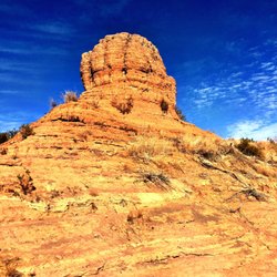
Places to Take Pictures in Henderson, Nevada
Bike Paths in Henderson, Nevada
Night Hike in Henderson, Nevada
Walking Trails in Henderson, Nevada
Easy Hikes in Henderson, Nevada
Public Running Track in Henderson, Nevada
Hiking Trails in Henderson, Nevada
Fishing Spots in Henderson, Nevada
Watch Sunset in Henderson, Nevada
Mountain Biking in Henderson, Nevada
Off Road Trails in Henderson, Nevada
Dog Friendly Hiking Trails in Henderson, Nevada
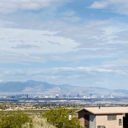
Lookout Points in Henderson, Nevada
Running Routes in Henderson, Nevada
Hiking Club in Henderson, Nevada
Scenic Overlook in Henderson, Nevada
Night View in Henderson, Nevada
Secluded Spots in Henderson, Nevada
Walking Groups in Henderson, Nevada
Jogging Trails in Henderson, Nevada
Trending Searches in Henderson, NV
Botanical Gardens near Union Pacific Railroad Trail
Bounce House Rentals near Union Pacific Railroad Trail
Campgrounds near Union Pacific Railroad Trail
Cliff Jumping near Union Pacific Railroad Trail
Dog Friendly Things To Do near Union Pacific Railroad Trail
Flower Fields near Union Pacific Railroad Trail
Flower Shop near Union Pacific Railroad Trail
Garage Sales near Union Pacific Railroad Trail
Garden Center near Union Pacific Railroad Trail
Hair near Union Pacific Railroad Trail
Lakes & Ponds near Union Pacific Railroad Trail
Nurseries & Gardening near Union Pacific Railroad Trail
Outdoor Activities near Union Pacific Railroad Trail
Outdoor Furniture Stores near Union Pacific Railroad Trail
Parks near Union Pacific Railroad Trail
Party Equipment Rentals near Union Pacific Railroad Trail
Pedicure near Union Pacific Railroad Trail
Photo Spots near Union Pacific Railroad Trail
Pick Your Own Farms near Union Pacific Railroad Trail
Picnic Areas near Union Pacific Railroad Trail
Places To Take Pictures near Union Pacific Railroad Trail
Rock Quarry near Union Pacific Railroad Trail
Running Trails near Union Pacific Railroad Trail
Rv Rental near Union Pacific Railroad Trail
Strawberry Picking near Union Pacific Railroad Trail
Sunrise View near Union Pacific Railroad Trail
Swimming Holes near Union Pacific Railroad Trail
Table And Chair Rentals near Union Pacific Railroad Trail
Browse Articles
Browse Nearby
BEST of Henderson, Nevada Things to Do near Union Pacific Railroad Trail
BEST of Henderson, Nevada Coffee near Union Pacific Railroad Trail
BEST of Henderson, Nevada Restaurants near Union Pacific Railroad Trail
BEST of Henderson, Nevada Parks near Union Pacific Railroad Trail
BEST of Henderson, Nevada Breakfast near Union Pacific Railroad Trail
BEST of Henderson, Nevada Horseback Riding near Union Pacific Railroad Trail
BEST of Henderson, Nevada Hotels near Union Pacific Railroad Trail
Browse Brands
Related Searches in Henderson, NV
Affordable Kayak Rental Services in Henderson, Nevada
Best Fishing Locations and Guides in Henderson, Nevada
Best Nature Trails for Hiking in Henderson, Nevada
Best Places for Horseback Riding in Henderson, Nevada
Check Out Off Road Trails in Henderson, Nevada
Discover Dog Friendly Trails to Explore in Henderson, Nevada
Discover Scenic Mountain Bike Trails Near Henderson, Nevada
Discover Top Nature Parks to Visit in Henderson, Nevada
Discover Walking Parks in Henderson, Nevada Near You
Discover a Hiking Trail in Henderson, Nevada
Discover the Best Night Hike Trails in Henderson, Nevada
Discover the Best Running Track in Henderson, Nevada
Dog-Friendly Hikes With Dogs in Henderson, Nevada
Enjoy Camping Adventures Around Henderson, Nevada
Enjoy Exciting Mountain Biking Adventures in Henderson, Nevada
Enjoy Kayaking Adventures in Henderson, Nevada
Enjoy Tent Camping Spots Around Henderson, Nevada
Enjoy the Best Walking Path in Henderson, Nevada
Enjoy the Best Walking Trails in Henderson, Nevada
Exciting Cliff Jumping Spots in Henderson, Nevada
Explore Beautiful Parks and Green Spaces in Henderson, Nevada
Explore Easy Hikes Perfect for All in Henderson, Nevada
Explore Fun Activities to Do in Henderson, Nevada
Explore Popular Campgrounds Near Henderson, Nevada
Explore the Best Beach Spots in Henderson, Nevada
Explore the Best Boating Spots in Henderson, Nevada
Explore the Best Swimming Holes Around Henderson, Nevada
Explore the Best Trail Options in Henderson, Nevada
Family Friendly Hiking With Kids in Henderson, Nevada
Find Beautiful Views in Henderson, Nevada
Find Popular Ziplining Spots Around Henderson, Nevada
Find the Best Parks for Picnics in Henderson, Nevada
Find the Best Scenic View Locations in Henderson, Nevada
Great Places to Walk in Henderson, Nevada
Hiking Trails With Waterfalls in Henderson, Nevada
Off Leash Dog Hiking Trails in Henderson, Nevada
Plan a Scenic Drive Route Near Henderson, Nevada
Popular Fishing Spots to Explore in Henderson, Nevada
Popular Outdoor Activities to Try in Henderson, Nevada
Popular Picnic Spots to Visit in Henderson, Nevada
Safe River Swimming Areas in Henderson, Nevada
Safe and Fun Parks for Kids in Henderson, Nevada
Top Climbing Spots and Gyms in Henderson, Nevada
Top Paddleboarding Activities in Henderson, Nevada
Top Running Trails to Explore in Henderson, Nevada
Top Swimming Lakes to Enjoy in Henderson, Nevada
Top Swimming Spots and Pools in Henderson, Nevada
Top Things to Do With Kids in Henderson, Nevada
People who viewed Union Pacific Railroad Trail also viewed
McCullough Hills Trail
13 reviews
Lake Mead Parkway Trail
2 reviews
Whitney Mesa Recreation Area
57 reviews
I-215 East Beltway Trail
2 reviews
Southeast
Cactus Wren Trail
2 reviews
Black Mountain Trail
50 reviews
Wetlands Trail Connector
6 reviews
Petroglyph Trail
4 reviews
Lake Las Vegas Overlook
2 reviews
Cadence Central Park
13 reviews