Amargosa Trail Photos


You might also consider
More like Amargosa Trail
Recommended Reviews - Amargosa Trail
Start your review...

Reviews With Photos - Amargosa Trail


This starts as a mild hike but as you progress it does get more challenging. If you take your time I'd say it's about 20-30 minutes before you reach the challenging part. I like parking at Hidden Falls Park off of Horizon Drive. To me, sitting in the grass is a nice way to cool off after this hike. During summer months, it's probably best to go early in the morning otherwise it's unbearably hot.

I like that these trails are near a park and neighborhood, just in case you forget water you can buy some right down the street. Short drive or walk up a hill past the Hidden Falls Park. We only explored the trails a bit since it was hot and sunny that day. I didn't find any shade on the trail so keep that in mind when venturing out. There are multiple routes you can take that aren't too difficult, loose rocks can be slippery, so be careful. You can make it a short hike or longer hike. Be safe and hydrate!

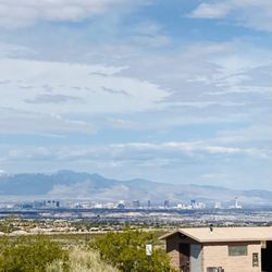
So many trails, so little time. When you live in Henderson, you'll find a multitude of trails for hiking, biking and taking in the view. Amargosa Trail stretches all the way through Henderson. You can start from Horizon Ridge Parkway going through Green Valley Ranch and ending at St. Rose Parkway by Eastern. The trail has paved and natural parts. The natural part of the trail takes you up to some beautiful views of the city. With several trailheads to this path, it's easily accessible. I certainly enjoyed this trail and happy that it's close to home.

I've done this trail twice in the last couple of weeks (started off on gibson and some neighborhood street the first time). The first time I did this trail, I wasn't prepared at all and decided to turn back after a mile and a half because the sun was beating down on me and the temps started reaching into the 106 107 range.. This morning, I started the trail off at the hidden falls park. The trail itself is very easy and as someone else said, there are tons of branch offs from the original trail itself. The one thing I do recommend is carry at least 2 liters of water with you, and PLEASE wear appropriate shoes as there are a lot of sections with slippery gravel/rock. There are steap parts to this trail both ways, some parts for me were hands on knees. There is no shade on the trail but morning was cloudy, cool, and there was a nice refreshing breeze up there, I still needed 2 liters of water. I also saw a bunny on the trail... pretty cute c: All in all, really easy trail. Something to get your heart rate up and its the perfect excuse to get out of the house and experience nature!

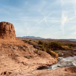
Today was my first time on Amargosa Trail. We parked at Hidden Falls Park and started off with our dog who, admittedly, is a much better hiker than I am. That being said, we didn't make it to the next trailhead but got up high enough to enjoy spectacular views of the valley. I'd say this could be a pretty good workout if you make it one, or a leisurely hike that offers breathtaking sights of Black Mountain and incredible views. Also, from Hidden Falls there's a nice little walking trail that loops back and forth, takes only 10 minutes or so to get to the "end", and gives views of the park and valley below. What a great place for a hike on a nice day - I feel lucky to live so close to it! Can't wait to go farther next time.

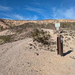
Shaded Canyon Trailhead part of Amargosa Trail has a few picnic benches and bike racks to park your bicycles. Nice view of the Strip too from here. Just heed the warning signs. Gravel can be slippery and there are some dips and sharp twists along this trail ...and most importantly please bring water with you. It's crazy how I've run into people w/o bottled water along the way.


Great Trail in Henderson. I took my cousins advice to try this spot out a year or so ago. This trail makes for a good workout, it's not too parlous but be sure to have a good pair of shoes or hiking boots. The path can get kind of narrow in some parts and than expand in others. The top of the trail gives great views of vegas and henderson. This is a great spot to see beautiful sunsets in the spring before the weather gets too hot. There's plenty of signs to let you know where your'e going and the distance to get there. Watch out for loose rocks that can cause you to slip , I have taken a few spills but nothing serious. Also be courteous to fellow hikers, if they need to get by and it's a narrow path just stand aside to let them pass. Make sure to bring lots of water with you. It's always wise to carry extra than to not have enough. Not to mention that this trail gives you a work out so you will definitely be craving some water during and after the hike.

nice spot for a trail run with a few options. the trail is well marked and there is plenty of parking and access to the McCullough trailhead. Out and back is about 5 or 6 miles and will give even the best runner a challenge. make sure to wear proper trail running shoes and bring hydration when it's hot. There are no fountains along this trail.

3 years ago
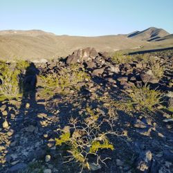
The address takes you directly to a parking lot and there is a sign that says Amargosa Trail to lead you to the trail but there are a bit of areas that branch off so it can be a bit confusing. I would definitely suggest downloading a separate trail map of the area if you are worried about getting a bit lost. The views from up higher are beautiful and once you are up there you can see a better view of the different trails that branch off. It is a pretty good walk/hike and as you get higher it can be a bit more difficult. There is not much shade so I would definitely make sure to have enough water if going in the warmer weather or wait till it gets a bit cooler. I personally wouldn't walk here by myself just because last time I was there I saw a tent, so I would just be cautious if going alone. read more


1 year ago
3 years ago
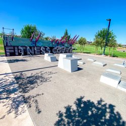
Beautiful area!! Love how the trail starts off with a blue and white playground, bathrooms, and a drinking fountain. There are grassy hills. read more


1 year ago
This starts as a mild hike but as you progress it does get more challenging. If you take your time I'd say it's about 20-30 minutes before you reach the challenging part. I like parking at Hidden Falls Park off of Horizon Drive. To me, sitting in the grass is a nice way to cool off after this hike. During summer months, it's probably best to go early in the morning otherwise it's unbearably hot. read more


I like that these trails are near a park and neighborhood, just in case you forget water you can buy some right down the street. Short drive or walk up a hill past the Hidden Falls Park. We only explored the trails a bit since it was hot and sunny that day. I didn't find any shade on the trail so keep that in mind when venturing out. There are multiple routes you can take that aren't too difficult, loose rocks can be slippery, so be careful. You can make it a short hike or longer hike. Be safe and hydrate! read more

9 years ago
So many trails, so little time. When you live in Henderson, you'll find a multitude of trails for hiking, biking and taking in the view. Amargosa Trail stretches all the way through Henderson. You can start from Horizon Ridge Parkway going through Green Valley Ranch and ending at St. Rose Parkway by Eastern. The trail has paved and natural parts. The natural part of the trail takes you up to some beautiful views of the city. With several trailheads to this path, it's easily accessible. I certainly enjoyed this trail and happy that it's close to home. read more


11 years ago
I've done this trail twice in the last couple of weeks (started off on gibson and some neighborhood street the first time). The first time I did this trail, I wasn't prepared at all and decided to turn back after a mile and a half because the sun was beating down on me and the temps started reaching into the 106 107 range.. This morning, I started the trail off at the hidden falls park. The trail itself is very easy and as someone else said, there are tons of branch offs from the original trail itself. The one thing I do recommend is carry at least 2 liters of water with you, and PLEASE wear appropriate shoes as there are a lot of sections with slippery gravel/rock. There are steap parts to this trail both ways, some parts for me were hands on knees. There is no shade on the trail but morning was cloudy, cool, and there was a nice refreshing breeze up there, I still needed 2 liters of water. I also saw a bunny on the trail... pretty cute c: All in all, really easy trail. Something to get your heart rate up and its the perfect excuse to get out of the house and experience nature! read more


Today was my first time on Amargosa Trail. We parked at Hidden Falls Park and started off with our dog who, admittedly, is a much better hiker than I am. That being said, we didn't make it to the next trailhead but got up high enough to enjoy spectacular views of the valley. I'd say this could be a pretty good workout if you make it one, or a leisurely hike that offers breathtaking sights of Black Mountain and incredible views. Also, from Hidden Falls there's a nice little walking trail that loops back and forth, takes only 10 minutes or so to get to the "end", and gives views of the park and valley below. What a great place for a hike on a nice day - I feel lucky to live so close to it! Can't wait to go farther next time. read more

14 years ago
Shaded Canyon Trailhead part of Amargosa Trail has a few picnic benches and bike racks to park your bicycles. Nice view of the Strip too from here. Just heed the warning signs. Gravel can be slippery and there are some dips and sharp twists along this trail ...and most importantly please bring water with you. It's crazy how I've run into people w/o bottled water along the way. read more


8 years ago
Nice views from this trail! More fun if you venture away from the actual train but stay away from the power poles up top! read more

12 years ago
13 years ago
14 years ago
This is my favorite place for a good morning workout. You will work up a good sweat here! I like to take the trail towards black mt and then wind back down the mt once i see the view of the city. Takes about half an hour. read more


10 years ago
Great Trail in Henderson. I took my cousins advice to try this spot out a year or so ago. This trail makes for a good workout, it's not too parlous but be sure to have a good pair of shoes or hiking boots. The path can get kind of narrow in some parts and than expand in others. The top of the trail gives great views of vegas and henderson. This is a great spot to see beautiful sunsets in the spring before the weather gets too hot. There's plenty of signs to let you know where your'e going and the distance to get there. Watch out for loose rocks that can cause you to slip , I have taken a few spills but nothing serious. Also be courteous to fellow hikers, if they need to get by and it's a narrow path just stand aside to let them pass. Make sure to bring lots of water with you. It's always wise to carry extra than to not have enough. Not to mention that this trail gives you a work out so you will definitely be craving some water during and after the hike. read more


nice spot for a trail run with a few options. the trail is well marked and there is plenty of parking and access to the McCullough trailhead. Out and back is about 5 or 6 miles and will give even the best runner a challenge. make sure to wear proper trail running shoes and bring hydration when it's hot. There are no fountains along this trail. read more

12 years ago
A few months ago, I stumble upon this trail not knowing that it was actually a trail not just some master planned community with nice paved sidewalks/street. I would definitely recommend everyone to check this trail out. read more


9 years ago
13 years ago
11 years ago
More info about Amargosa Trail
281 W Horizon Dr
Henderson, NV 89002
Directions
Hours
Outdoor Amenities
Ask the Community - Amargosa Trail
Review Highlights - Amargosa Trail
You might also consider


Amargosa Trail - hiking - Updated July 2026
Best of Henderson
People found Amargosa Trail by searching for…
Beautiful Views in Henderson, Nevada
Scenic Overlook in Henderson, Nevada
Walking Trails in Henderson, Nevada
Hiking Trails in Henderson, Nevada
Off Road Trails in Henderson, Nevada
Easy Hikes in Henderson, Nevada
Hot Springs in Henderson, Nevada
Running Trails in Henderson, Nevada
Bike Paths in Henderson, Nevada
Mountain Biking in Henderson, Nevada
Watch Sunset in Henderson, Nevada
Lakes & Ponds in Henderson, Nevada
Sunset View in Henderson, Nevada
Running Routes in Henderson, Nevada
Rattlesnake in Henderson, Nevada
Dog Friendly Hiking Trails in Henderson, Nevada
Abandoned Places in Henderson, Nevada
Things to Do Alone in Henderson, Nevada
Cheap Fun Things to Do in Henderson, Nevada
Scenic View in Henderson, Nevada
Parks With Shade in Henderson, Nevada
Trending Searches in Henderson, NV
4th Of July Fireworks near Amargosa Trail
Black Owned Nail Salons near Amargosa Trail
Boat Rental near Amargosa Trail
Cliff Jumping near Amargosa Trail
Jet Ski Rental near Amargosa Trail
Kayak Rental near Amargosa Trail
Lakes & Ponds near Amargosa Trail
Off Road Trails near Amargosa Trail
Outdoor Activities near Amargosa Trail
Parks For Picnics near Amargosa Trail
Places To Walk Around near Amargosa Trail
Public Pools near Amargosa Trail
Public Shower near Amargosa Trail
River Swimming near Amargosa Trail
Rock Quarry near Amargosa Trail
Scenic Night View near Amargosa Trail
Scenic Overlook near Amargosa Trail
Secluded Spots near Amargosa Trail
Soccer Store near Amargosa Trail
Splash Pad near Amargosa Trail
Strawberry Picking near Amargosa Trail
Sunrise View near Amargosa Trail
Swimming Holes near Amargosa Trail
Swimming Lakes near Amargosa Trail
Watch Sunset near Amargosa Trail
Browse Articles
Browse Nearby
BEST of Henderson, Nevada Coffee near Amargosa Trail
BEST of Henderson, Nevada Restaurants near Amargosa Trail
BEST of Henderson, Nevada Things to Do near Amargosa Trail
BEST of Henderson, Nevada Walking Trails near Amargosa Trail
BEST of Henderson, Nevada Breakfast near Amargosa Trail
BEST of Henderson, Nevada Parks near Amargosa Trail
BEST of Henderson, Nevada Caves near Amargosa Trail
Browse Brands
Related Searches in Henderson, NV
Affordable Kayak Rental Services in Henderson, Nevada
Best Fishing Locations and Guides in Henderson, Nevada
Best Nature Trails for Hiking in Henderson, Nevada
Best Places for Horseback Riding in Henderson, Nevada
Check Out Off Road Trails in Henderson, Nevada
Discover Dog Friendly Trails to Explore in Henderson, Nevada
Discover Scenic Mountain Bike Trails Near Henderson, Nevada
Discover Top Nature Parks to Visit in Henderson, Nevada
Discover Walking Parks in Henderson, Nevada Near You
Discover a Hiking Trail in Henderson, Nevada
Discover the Best Night Hike Trails in Henderson, Nevada
Discover the Best Running Track in Henderson, Nevada
Dog-Friendly Hikes With Dogs in Henderson, Nevada
Enjoy Camping Adventures Around Henderson, Nevada
Enjoy Exciting Mountain Biking Adventures in Henderson, Nevada
Enjoy Kayaking Adventures in Henderson, Nevada
Enjoy Tent Camping Spots Around Henderson, Nevada
Enjoy the Best Walking Path in Henderson, Nevada
Enjoy the Best Walking Trails in Henderson, Nevada
Exciting Cliff Jumping Spots in Henderson, Nevada
Explore Beautiful Parks and Green Spaces in Henderson, Nevada
Explore Easy Hikes Perfect for All in Henderson, Nevada
Explore Fun Activities to Do in Henderson, Nevada
Explore Popular Campgrounds Near Henderson, Nevada
Explore the Best Beach Spots in Henderson, Nevada
Explore the Best Boating Spots in Henderson, Nevada
Explore the Best Swimming Holes Around Henderson, Nevada
Explore the Best Trail Options in Henderson, Nevada
Family Friendly Hiking With Kids in Henderson, Nevada
Find Beautiful Views in Henderson, Nevada
Find Popular Ziplining Spots Around Henderson, Nevada
Find the Best Parks for Picnics in Henderson, Nevada
Find the Best Scenic View Locations in Henderson, Nevada
Great Places to Walk in Henderson, Nevada
Hiking Trails With Waterfalls in Henderson, Nevada
Off Leash Dog Hiking Trails in Henderson, Nevada
Plan a Scenic Drive Route Near Henderson, Nevada
Popular Fishing Spots to Explore in Henderson, Nevada
Popular Outdoor Activities to Try in Henderson, Nevada
Popular Picnic Spots to Visit in Henderson, Nevada
Safe River Swimming Areas in Henderson, Nevada
Safe and Fun Parks for Kids in Henderson, Nevada
Top Climbing Spots and Gyms in Henderson, Nevada
Top Paddleboarding Activities in Henderson, Nevada
Top Running Trails to Explore in Henderson, Nevada
Top Swimming Lakes to Enjoy in Henderson, Nevada
Top Swimming Spots and Pools in Henderson, Nevada
Top Things to Do With Kids in Henderson, Nevada
People who viewed Amargosa Trail also viewed
Black Mountain Trail
50 reviews
Whitney Mesa Recreation Area
57 reviews
Park Peak Trail 403
4 reviews
Lake Las Vegas Overlook
2 reviews
Petroglyph Trail
4 reviews
Edna Gray Trail
1 review
Wetlands Trail Connector
6 reviews
Red and Black Mountain
3 reviews
Lake Mead Parkway Trail
2 reviews
I-215 East Beltway Trail
2 reviews
Southeast