Liberty Bell Arch Photos


You might also consider
More like Liberty Bell Arch
Recommended Reviews - Liberty Bell Arch
Start your review...

Reviews With Photos

This review is for Liberty Bell Arch & Colorado Overlook which was a ~5.1 miles round trip that took ~3 hours to complete. Located about 30 minutes from Las Vegas; this was another spectacular hike in the area besides Red Rock Canyon and Valley of Fire. A third of the trail was through sand making it a little difficult to walk through. There were a few steep inclines near the end and also on the way back before the mining cart. Stunning views of the mountains, Colorado River and the Liberty Bell Arch! Short video of the hike for those interested! https://youtu.be/ZspcN8eeRlQ

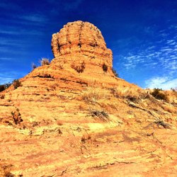
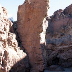
This is one of our favorite hikes, and it's a great one to bring friends along. It's not particularly strenuous (but that is subjective), you get scenic views, and it's unique. We went with two friends again this morning. The weather was overcast, and we had a few sprinkles, but it didn't rain on us. The air was crisp, and we had the trail to ourselves for the first part of the hike. The trail is a combination of sand, gravel, and hard-packed dirt; I had to take my boots off at one point to get a couple of rocks out since I wasn't wearing gaiters. You get a good leg workout going through the sandy parts. Along this trail, you'll have some flat parts as well as inclines, but nothing too steep, IMHO. You will get views of the Mike O'Callaghan-Pat Tillman Memorial Bridge in the distance as you approach the Liberty Bell Arch, so be sure to look to your right. I love a good arch, and this one is indeed shaped like the liberty bell. You could turn around at this point, but if you keep going up the trail about half a mile, you will be at the overlook where you have excellent views of the Colorado River. The out and back distance for this hike was 5.2 miles, according to my Garmin today. We spent about 20 minutes at the overlook, enjoying our snacks. Depending on your hiking speed and how long you want to enjoy the views, expect to spend about 3 to 3.5 hours total for this hike. It's best to do it now when it's nice and cool; this trail is closed during the summer because it's just too hot!

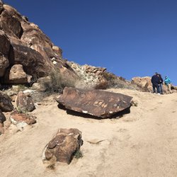
Liberty Bell Arch is another amazing hike not too far outside of Las Vegas. Featuring a rock arch that resembles a bell hence the name and an amazing view looking down at the Colorado River and a few of the hot springs hikes. The hike is about 2 miles to the arch and another .5 mile to the overlook. 5 miles round trip. And took about 3 hrs of actual hiking at an easy pace. Nothing too difficult but there are some inclines and declines, it wouldn't be fun without them. The arch is huge. It looks smaller at a distance. I wouldn't suggest climbing up it. It may seem easy but you might have trouble coming down it. There's also an old mine and cable car somewhere in the middle. The hike continues left of the cable car incase you can't find where to go. The trail is noticeable but I've heard sometimes it's not so people tend to turn back. There's a decent size parking lot that is shared with others doing the nearby hot springs hike. It's also not gated and has no restrooms. I'm definitely doing this hike again.

Hiking the Liberty Bell Arch trail was one of the greastest and most important things I've done in my entire life. I cannot emphasize this enough. It's easy to get to the trail. Just drive past the Hoover Dam a little bit and pull off and park in Arizona. I got there around 6:30 AM on a Thursday and the only two vehicles in the parking lot were overnight campers. This is no toilet here, so don't drink too much coffee on the way. The hike itself is pretty easy. I didn't find it to be much of a challenge. You get to see birds along the way, as well as lots of cacti and yucca. Be careful not to fall into the abandoned magnesium mine! There is a lot of old, abandoned mining gear from the 1940s laying around. It is extremely dangerous around the mining holes. You will die if you fall in there. The Liberty Bell Arch is an amazing geological site. It was handcrafted by God for all of us to enjoy. God wanted everyone who sees it to stop and think about the Liberty Bell in Philadelphia. If you're too lazy to fly to Philadelphia to see the real bell, this is basically the same thing. Keep on lugging upward until you get to the end of the trail. When you can see the Colorado River, you'll know you're almost at the end. The top viewing deck at the end is a great smoke spot. You can look down and admire the mighty Colorado River. This hike is pretty easy. I'm in terrible physical shape and I've had multiple leg surgeries in recent years and I didn't have even the slightest degree of difficulty completing this hike. I recommend bringing lots of water and dressing in layers of clothing. Best of luck to all hikers. Five stars

Liberty Bell Arch is about a 5-6 mile hike and the route is largely marked by cairns. It took my husband and I 4 hours to complete as first-timers. I utilized Norm. K.'s review in addition to the write-ups on hikinglasvegas.com and birdandhike.com to navigate the hike. The beginning of the hike was a bit discouraging - there is a complete lack of markers and cairns are extremely sparse. After maybe 3/4 of a mile in, the trails become more visible and cairns start sprouting up like seedlings during spring. Once you get about a mile in, you start coming across the focal points of the hike. First up is the old ore car and the abandoned mine. We explored the mine, although it's quite small. Still neat to check out though. Then you come across the hike's namesake, the Liberty Bell Arch. Last but not least is a view of the Colorado river. We took our snack break here taking in the views. I wouldn't recommend this hike for beginners. I'd also only undertake this hike in the winter or spring since there's no shade provided. Overall though, this hike was an adventure! YELP'S 2018 REVIEW CHALLENGE: #5

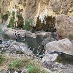
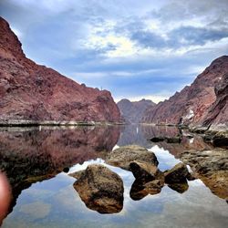
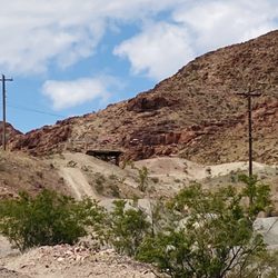
This hike has been on my list for a while and I was excited when a fellow Yelper agreed to go with me. She had done it before and I figured she knew where she was going. This was one of the prettiest hikes I have done and thanks to a wet and wonderful winter, plenty of blooming wildflowers decorated the trail. The hike is pretty easy to access. It is south of Hoover Dam on Highway 93. The parking lot is on the left side of the highway and easy to miss so be careful. I passed it and had to come back, but it is a nice size lot and hold plenty of spaces. Unfortunately, no restrooms here. Once you have parked the car, be sure to view the trail map for guidance or look at Norm's review for help. You will begin your hike by heading down a small hill and under the highway bridge. Be sure to stay in the wash (middle) as the trail will lead you down into a small canyon and then you will see the sign that directs you to the arch. This same area also houses the trail to the Arizona Hot Springs. It is approximately 5 miles round trip and there are plenty of opportunities for a light cardio workout. There is no shade so this trail is best for hiking during the spring and fall. We chose to complete it in March yet it was still pretty warm at times. The trail does ascend and descends quite often. After passing an old mining car that was used to mine ore, you are almost there. You can see the Arch in the distance and if you only want to look at it from a distance, great viewing from the top of this mountain. We chose to press on and get closer. The Arch is majestic and commanding. Mother Nature sure does produce some magical sites! In addition, if you take the time to look behind you, there is a nice view of the Mike O'Callaghan/Pat Tillman bridge. Once we reached the arch, we took some great shots and pressed on towards the overlook of the Colorado River. It is not recommended to climb the arch although there are always "those people" that feel they have to get even closer. The idea is to enjoy it from a distance and leave the rock undisturbed. The overlook of the Colorado River is an additional distance of a little over a half mile. Believe me, it is so worth it! The views of the river are phenomenal and makes you want to dive right off the cliff but don't. Lots of boats coming up the river and kayaks too. We just made ourselves at home for at least 30 minutes snacking and taking in Black Canyon and the Colorado River. This is a hike that I would definitely repeat again and again as it supplies all kinds of beauty and fun.

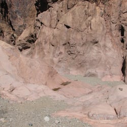
This is one of my favorite hikes. It's moderately strenuous at just over 6 miles. I refer to it as a triple treat hike because there are three distinct features to see on this hike. To get to the trailhead, take the new O'Callaghan-Tillman Memorial Bridge near Hoover Dam and go south in Arizona to Mile Marker 4 on US 93. There is a left turn lane that crosses the northbound lanes and heads to a new blacktop road that goes up a hill and to a new large parking area. For those familiar with the Arizona Hot Springs hike, this is the new parking for that hike, too, as the new road has closed the old parking area. From the parking lot, head downhill into the wash. To get into the wash, follow the use trail that begins just past the interpretive markers at the end of the parking lot. After going down this path from the parking lot, make sure you go under the double set of bridges and follow the wash west for about 9/10 of a mile. This is where you make a right turn and head north out of this wash. There is a small cairn along the wash that is easy to miss. Hike up a small hill and you'll be in a small canyon that heads north. You pick up the trail easily here, and follow it for about 1/4 mile. Along the way, you'll find a very large cairn with a wooden stake. After this cairn, as you travel north, pay attention because the trail will leave this wash and head up a hill to an old mining road. You can see the stacked stones from when it was a road. At this road, turn left and follow the road. It eventually makes a curve near an old mine prospect which didn't get dug very much. There's another set of nice stonework along the road as you go up the hill. Continue along the road and you'll start to see debris from the mining that took place at a nearby manganese mine. When you crest the hill and come around a curve, on a hill in front of you, there's an ore car laying on the side of the hill. The old manganese mine is in the wash below this car on the other side of the ridge. Keep to the left at any trails you see. These spider trails just go to overlooks and a couple are dangerous, because a fall could land you 50 feet below in the old mine. The trail to the left goes over some jagged rock and then starts down the other side. Soon you come to a fork in the trail. If you want to investigate the mine (this is one I will tell you is safe to enter), it will add about 1/2 mile to your total hike. There are some rails in the dirt floor of the mine and several air holes are cut in the sturdy rock. To continue the hike, return to the fork and turn right. The mine is treat #1. The left fork continues down the hill and enters the wash. Periodically it will leave the wash and then come back in. At about two miles from the trailhead, or about 2.5 miles if you went to the mine, the trail comes out of the wash and heads west up a hill to a saddle. In front of you, Liberty Bell Arch can be seen. The best photos come from the south but feel free to take all you want wherever you are on the hike. At the saddle, make a left turn, and head southwest following the trail. You're going up another hill until you're almost in line with the arch. Near the arch, the trail cuts south and as you pass the arch and then look back, this is where you get the best view of the result of a natural erosion process. This is treat #2. Continue following the trail south. You hike past a field that has some enormous boulders that are amazing to see. At one time, they broke off the hill above and rolled here. The trail is very evident here as it is well traveled. The footing can be bad because the rocks can be sharp. Take care as you hike along. Eventually, you'll go around the side of a hill and the view of Liberty Bell Arch is gone until you return. From here, there are about 4 ridges to go up and over. Stop as needed and get your breath. Make sure you've brought enough water with you--you should be using a Camelbak for a hike like this. When you get to the last ridge, you come up on a mesa and below you to your left is treat #3, a view of the Colorado River about 1,000 feet below as it winds toward Willow Beach in Arizona. When you arrive on the mesa, the trail goes near the edge so you can get great views of the Colorado. It is truly beautiful up here. Explore the mesa, look north and see the bypass bridge, and stop and sit on one of the rocks for a snack. When you're done enjoying the mesa, retrace your steps. THe toughest part now will be coming back up the wash to the car from the Liberty Bell Arch turnoff. It always seems so tough to get that last mile done with gravel under foot. I have done this hike about 7 times, twice from the new trailhead, and it truly is a treat! I have posted on EveryTrail the explanation and GPS coordinates from my last hike. We passed the turnoff to Liberty Bell, so don't follow me there but turn where the waypoint is. The link is http://www.everytrail.com/view_trip.php?trip_id=904927 Happy hiking!

OH MY WORD, YOU GUYS!!! Today's adventure was simply amazing. We ventured off to the Liberty Bell Arch but do you think that we stopped there? Of course not!!! We had to keep going up to the view of the COLORADO RIVER!!! This has to be one of my favorite hikes simply because of the view at the end. Go. You won't be disappointed. , Me.

The Liberty Bell Arch hike is one of my favorites. It's not a tough hike, but it does have its challenges. There is absolutely no shade. The sun will kick your buttocks if choose to do this hike after 12 PM. In fact, this hike is closed during the summer due to the extreme temperatures. The trail is visible on 95% of this hike. Some spots are not as clearly defined. My suggestion is to review the map located near the parking lot, go off memory if you've done the hike before, or have Norm K. as your guide. The hike is 2 miles from the parking lot to the Liberty Bell Arch and another .60 miles to the Colorado River overlook. Overall, this is another great hike not too far from Sin City. TIP #1: Location - Take the first left after the Hoover Dam is you're heading west on the freeway TIP #2: Follow the trail into the wash. A little less than a mile from the parking lot is where you turn right towards Liberty Bell Arch. There's also a sign and can easily be overlooked if you're not paying attention. TIP #3: Once over the first hill and towards the right is an old ore car that was left behind. Pretty cool. The mine is also located close by. TIP #4: I don't recommend climbing the Liberty Bell Arch. Don't do it. TIP #5: The views of the Colorado River is worth the hike. Just be careful. The drop down is over 1,000 feet. TIP #6: Bring enough hydration and snacks for energy. Peanut butter is my snack of choice. Leave no trace.

Sometimes I just need to get my lazy butt off the couch. The Liberty Bell Arch Hike is wonderful way to kick off a hiking adventure. Parking is paved with an abundance of spots especially during the week. Unfortunately they do not have restrooms from the start so I would stop before you get there. Now the beginning point for Liberty Bell and Arizona Hot Springs hike begin at the same point. Just before hitting the mile point you'll see the trail fork for the Liberty Bell. Parts of the trail are loose gravel but for the most part it's pretty packed dirt. Along the way you can see some of the old mining carts. The scenery is very picturesque. It's an easier hike that's well traveled. The view at the end is definitely worth it.

What an amazing hike! it exceeded my expectations. The hike is located along Highway 93, south of the Hoover Dam in Lake Mead National Recreation Area, about 45 minutes southeast of Las Vegas. From town, drive out to Lake Mead NRA, over the bridge into Arizona, and then down to the White Rock Canyon Trailhead. The hike is easy to moderate 5.5miles or so. There is a fair amount of up and down, and there is some scrambling and there's a good amount of walking through sand & gravel. You will be using the same trail-head as if you are going to Arizona Hot Springs. Instead of entering the slot canyon to the springs, you'll branch off to the right and follow a wash toward an abandoned magnesium mine. We saw an old ore hopper. Keep following the trail, you approach Liberty Bell Arch, which is a natural erosion of rock that resembles the Liberty bell. The entire hike was filled with beautiful colorful scenery and all kinds of terrain. The arch was grand and impressive. In the distance, you'll see the new O'Callaghan-Tillman Memorial Bridge that bypasses Hoover Dam. From the arch, continue following the trail as it goes up some ridges as you ascend to the highest point of the hike. The view from here is amazing. Below is the Colorado River separating Arizona and Nevada. It truly is an incredible sight as you look about 1,000 feet below and see boats and kayaks on the river.

This was a really great hike! The landscape was always changing so the hike stayed exciting- downhill and uphill portions, views of the old mines, the arch, and then the final beautiful view overlooking the Colorado River. I agree with the other reviews that this hike is moderately strenuous. There were some tougher uphill parts that left me a little winded, but the uphill parts were quickly followed by flat or downhill portions. The only tricky part of this hike is finding the trailhead. We knew we needed to make a right at some point (Norm K. said it was about 9/10 of a mile into the wash) but we saw a cairn less than half a mile in, and we decided to go that way. It looked like a path a first, but then the path kind of ended, so we somewhat forged our own. Luckily we ended up in the right place, but it was very unclear for a while. On the way out we followed the path that led us further into the wash. So it looks like you can take either trailhead, but the first one is not as clearly marked along the way. If you want a decent length hike (6 miles) with great views, then check this out!

this was an excellent hike. Easy to find thanks to all the reviews on here, first left past the 3 mile marker on highway 93 southbound. Since it has been so nice out the parking area was crowded so we parked on the side of the road exiting the area. Wile walking under the interstate there are options for the Hot Springs or the Liberty Bell Arch. The Liberty Bell is to the left and there is somewhat of a trail, it becomes clear after you are on it for a bit. I also didn't see where to continue to the Arch from the ore car at first but after seeing people coming up the hill it became obvious. The views are great seeing the different color rocks along the way to the Arch and the final scenic area where the Colorado can be seen below. Bring plenty of water and take your time, if an out of shape person like myself can make so will you!

We came with a social group and conquered over 5 miles and an elevation change of over 900'. The parking and bathrooms were well maintained, and the signage made clear the natural challenges presented in this part of the country. We easily followed the beaten path to see the arch and the Colorado River in 3.5 hours. Pro tips: wear hiking boots, wear layers, bring water and a snack, and plan for sun and wind. We were fortunate so many things were in bloom today. We'll do this hike again! read more


Such a fun rewarding hike with gorgeous views of the Colorado river! This hike is known for its interesting combination of features, including an old mine area, the iconic Liberty Bell Arch, and the river overlook. The hike was 4.55 miles round trip. Moderate, with a mix of inclines and flat sections. The trail can be sandy and rocky in places, so wear good hiking footwear. It took about 3 hours round trip because we spent about 30 minutes enjoying the view up top. Make sure to bring water and some snacks to enjoy before hiking back down. Take lots of pictures too. This hike was very peaceful and serene. You will love it. I can't wait to do this hike again with my girls! read more


11 months ago
This review is for Liberty Bell Arch & Colorado Overlook which was a ~5.1 miles round trip that took ~3 hours to complete. Located about 30 minutes from Las Vegas; this was another spectacular hike in the area besides Red Rock Canyon and Valley of Fire. A third of the trail was through sand making it a little difficult to walk through. There were a few steep inclines near the end and also on the way back before the mining cart. Stunning views of the mountains, Colorado River and the Liberty Bell Arch! Short video of the hike for those interested! https://youtu.be/ZspcN8eeRlQ read more


This is one of our favorite hikes, and it's a great one to bring friends along. It's not particularly strenuous (but that is subjective), you get scenic views, and it's unique. We went with two friends again this morning. The weather was overcast, and we had a few sprinkles, but it didn't rain on us. The air was crisp, and we had the trail to ourselves for the first part of the hike. The trail is a combination of sand, gravel, and hard-packed dirt; I had to take my boots off at one point to get a couple of rocks out since I wasn't wearing gaiters. You get a good leg workout going through the sandy parts. Along this trail, you'll have some flat parts as well as inclines, but nothing too steep, IMHO. You will get views of the Mike O'Callaghan-Pat Tillman Memorial Bridge in the distance as you approach the Liberty Bell Arch, so be sure to look to your right. I love a good arch, and this one is indeed shaped like the liberty bell. You could turn around at this point, but if you keep going up the trail about half a mile, you will be at the overlook where you have excellent views of the Colorado River. The out and back distance for this hike was 5.2 miles, according to my Garmin today. We spent about 20 minutes at the overlook, enjoying our snacks. Depending on your hiking speed and how long you want to enjoy the views, expect to spend about 3 to 3.5 hours total for this hike. It's best to do it now when it's nice and cool; this trail is closed during the summer because it's just too hot! read more

Liberty Bell Arch is another amazing hike not too far outside of Las Vegas. Featuring a rock arch that resembles a bell hence the name and an amazing view looking down at the Colorado River and a few of the hot springs hikes. The hike is about 2 miles to the arch and another .5 mile to the overlook. 5 miles round trip. And took about 3 hrs of actual hiking at an easy pace. Nothing too difficult but there are some inclines and declines, it wouldn't be fun without them. The arch is huge. It looks smaller at a distance. I wouldn't suggest climbing up it. It may seem easy but you might have trouble coming down it. There's also an old mine and cable car somewhere in the middle. The hike continues left of the cable car incase you can't find where to go. The trail is noticeable but I've heard sometimes it's not so people tend to turn back. There's a decent size parking lot that is shared with others doing the nearby hot springs hike. It's also not gated and has no restrooms. I'm definitely doing this hike again. read more


4 years ago
Hiking the Liberty Bell Arch trail was one of the greastest and most important things I've done in my entire life. I cannot emphasize this enough. It's easy to get to the trail. Just drive past the Hoover Dam a little bit and pull off and park in Arizona. I got there around 6:30 AM on a Thursday and the only two vehicles in the parking lot were overnight campers. This is no toilet here, so don't drink too much coffee on the way. The hike itself is pretty easy. I didn't find it to be much of a challenge. You get to see birds along the way, as well as lots of cacti and yucca. Be careful not to fall into the abandoned magnesium mine! There is a lot of old, abandoned mining gear from the 1940s laying around. It is extremely dangerous around the mining holes. You will die if you fall in there. The Liberty Bell Arch is an amazing geological site. It was handcrafted by God for all of us to enjoy. God wanted everyone who sees it to stop and think about the Liberty Bell in Philadelphia. If you're too lazy to fly to Philadelphia to see the real bell, this is basically the same thing. Keep on lugging upward until you get to the end of the trail. When you can see the Colorado River, you'll know you're almost at the end. The top viewing deck at the end is a great smoke spot. You can look down and admire the mighty Colorado River. This hike is pretty easy. I'm in terrible physical shape and I've had multiple leg surgeries in recent years and I didn't have even the slightest degree of difficulty completing this hike. I recommend bringing lots of water and dressing in layers of clothing. Best of luck to all hikers. Five stars read more


8 years ago
Liberty Bell Arch is about a 5-6 mile hike and the route is largely marked by cairns. It took my husband and I 4 hours to complete as first-timers. I utilized Norm. K.'s review in addition to the write-ups on hikinglasvegas.com and birdandhike.com to navigate the hike. The beginning of the hike was a bit discouraging - there is a complete lack of markers and cairns are extremely sparse. After maybe 3/4 of a mile in, the trails become more visible and cairns start sprouting up like seedlings during spring. Once you get about a mile in, you start coming across the focal points of the hike. First up is the old ore car and the abandoned mine. We explored the mine, although it's quite small. Still neat to check out though. Then you come across the hike's namesake, the Liberty Bell Arch. Last but not least is a view of the Colorado river. We took our snack break here taking in the views. I wouldn't recommend this hike for beginners. I'd also only undertake this hike in the winter or spring since there's no shade provided. Overall though, this hike was an adventure! YELP'S 2018 REVIEW CHALLENGE: #5 read more


This hike has been on my list for a while and I was excited when a fellow Yelper agreed to go with me. She had done it before and I figured she knew where she was going. This was one of the prettiest hikes I have done and thanks to a wet and wonderful winter, plenty of blooming wildflowers decorated the trail. The hike is pretty easy to access. It is south of Hoover Dam on Highway 93. The parking lot is on the left side of the highway and easy to miss so be careful. I passed it and had to come back, but it is a nice size lot and hold plenty of spaces. Unfortunately, no restrooms here. Once you have parked the car, be sure to view the trail map for guidance or look at Norm's review for help. You will begin your hike by heading down a small hill and under the highway bridge. Be sure to stay in the wash (middle) as the trail will lead you down into a small canyon and then you will see the sign that directs you to the arch. This same area also houses the trail to the Arizona Hot Springs. It is approximately 5 miles round trip and there are plenty of opportunities for a light cardio workout. There is no shade so this trail is best for hiking during the spring and fall. We chose to complete it in March yet it was still pretty warm at times. The trail does ascend and descends quite often. After passing an old mining car that was used to mine ore, you are almost there. You can see the Arch in the distance and if you only want to look at it from a distance, great viewing from the top of this mountain. We chose to press on and get closer. The Arch is majestic and commanding. Mother Nature sure does produce some magical sites! In addition, if you take the time to look behind you, there is a nice view of the Mike O'Callaghan/Pat Tillman bridge. Once we reached the arch, we took some great shots and pressed on towards the overlook of the Colorado River. It is not recommended to climb the arch although there are always "those people" that feel they have to get even closer. The idea is to enjoy it from a distance and leave the rock undisturbed. The overlook of the Colorado River is an additional distance of a little over a half mile. Believe me, it is so worth it! The views of the river are phenomenal and makes you want to dive right off the cliff but don't. Lots of boats coming up the river and kayaks too. We just made ourselves at home for at least 30 minutes snacking and taking in Black Canyon and the Colorado River. This is a hike that I would definitely repeat again and again as it supplies all kinds of beauty and fun. read more


This is one of my favorite hikes. It's moderately strenuous at just over 6 miles. I refer to it as a triple treat hike because there are three distinct features to see on this hike. To get to the trailhead, take the new O'Callaghan-Tillman Memorial Bridge near Hoover Dam and go south in Arizona to Mile Marker 4 on US 93. There is a left turn lane that crosses the northbound lanes and heads to a new blacktop road that goes up a hill and to a new large parking area. For those familiar with the Arizona Hot Springs hike, this is the new parking for that hike, too, as the new road has closed the old parking area. From the parking lot, head downhill into the wash. To get into the wash, follow the use trail that begins just past the interpretive markers at the end of the parking lot. After going down this path from the parking lot, make sure you go under the double set of bridges and follow the wash west for about 9/10 of a mile. This is where you make a right turn and head north out of this wash. There is a small cairn along the wash that is easy to miss. Hike up a small hill and you'll be in a small canyon that heads north. You pick up the trail easily here, and follow it for about 1/4 mile. Along the way, you'll find a very large cairn with a wooden stake. After this cairn, as you travel north, pay attention because the trail will leave this wash and head up a hill to an old mining road. You can see the stacked stones from when it was a road. At this road, turn left and follow the road. It eventually makes a curve near an old mine prospect which didn't get dug very much. There's another set of nice stonework along the road as you go up the hill. Continue along the road and you'll start to see debris from the mining that took place at a nearby manganese mine. When you crest the hill and come around a curve, on a hill in front of you, there's an ore car laying on the side of the hill. The old manganese mine is in the wash below this car on the other side of the ridge. Keep to the left at any trails you see. These spider trails just go to overlooks and a couple are dangerous, because a fall could land you 50 feet below in the old mine. The trail to the left goes over some jagged rock and then starts down the other side. Soon you come to a fork in the trail. If you want to investigate the mine (this is one I will tell you is safe to enter), it will add about 1/2 mile to your total hike. There are some rails in the dirt floor of the mine and several air holes are cut in the sturdy rock. To continue the hike, return to the fork and turn right. The mine is treat #1. The left fork continues down the hill and enters the wash. Periodically it will leave the wash and then come back in. At about two miles from the trailhead, or about 2.5 miles if you went to the mine, the trail comes out of the wash and heads west up a hill to a saddle. In front of you, Liberty Bell Arch can be seen. The best photos come from the south but feel free to take all you want wherever you are on the hike. At the saddle, make a left turn, and head southwest following the trail. You're going up another hill until you're almost in line with the arch. Near the arch, the trail cuts south and as you pass the arch and then look back, this is where you get the best view of the result of a natural erosion process. This is treat #2. Continue following the trail south. You hike past a field that has some enormous boulders that are amazing to see. At one time, they broke off the hill above and rolled here. The trail is very evident here as it is well traveled. The footing can be bad because the rocks can be sharp. Take care as you hike along. Eventually, you'll go around the side of a hill and the view of Liberty Bell Arch is gone until you return. From here, there are about 4 ridges to go up and over. Stop as needed and get your breath. Make sure you've brought enough water with you--you should be using a Camelbak for a hike like this. When you get to the last ridge, you come up on a mesa and below you to your left is treat #3, a view of the Colorado River about 1,000 feet below as it winds toward Willow Beach in Arizona. When you arrive on the mesa, the trail goes near the edge so you can get great views of the Colorado. It is truly beautiful up here. Explore the mesa, look north and see the bypass bridge, and stop and sit on one of the rocks for a snack. When you're done enjoying the mesa, retrace your steps. THe toughest part now will be coming back up the wash to the car from the Liberty Bell Arch turnoff. It always seems so tough to get that last mile done with gravel under foot. I have done this hike about 7 times, twice from the new trailhead, and it truly is a treat! I have posted on EveryTrail the explanation and GPS coordinates from my last hike. We passed the turnoff to Liberty Bell, so don't follow me there but turn where the waypoint is. The link is http://www.everytrail.com/view_trip.php?trip_id=904927 Happy hiking! read more


10 years ago
OH MY WORD, YOU GUYS!!! Today's adventure was simply amazing. We ventured off to the Liberty Bell Arch but do you think that we stopped there? Of course not!!! We had to keep going up to the view of the COLORADO RIVER!!! This has to be one of my favorite hikes simply because of the view at the end. Go. You won't be disappointed. , Me. read more

The Liberty Bell Arch hike is one of my favorites. It's not a tough hike, but it does have its challenges. There is absolutely no shade. The sun will kick your buttocks if choose to do this hike after 12 PM. In fact, this hike is closed during the summer due to the extreme temperatures. The trail is visible on 95% of this hike. Some spots are not as clearly defined. My suggestion is to review the map located near the parking lot, go off memory if you've done the hike before, or have Norm K. as your guide. The hike is 2 miles from the parking lot to the Liberty Bell Arch and another .60 miles to the Colorado River overlook. Overall, this is another great hike not too far from Sin City. TIP #1: Location - Take the first left after the Hoover Dam is you're heading west on the freeway TIP #2: Follow the trail into the wash. A little less than a mile from the parking lot is where you turn right towards Liberty Bell Arch. There's also a sign and can easily be overlooked if you're not paying attention. TIP #3: Once over the first hill and towards the right is an old ore car that was left behind. Pretty cool. The mine is also located close by. TIP #4: I don't recommend climbing the Liberty Bell Arch. Don't do it. TIP #5: The views of the Colorado River is worth the hike. Just be careful. The drop down is over 1,000 feet. TIP #6: Bring enough hydration and snacks for energy. Peanut butter is my snack of choice. Leave no trace. read more


8 years ago
Sometimes I just need to get my lazy butt off the couch. The Liberty Bell Arch Hike is wonderful way to kick off a hiking adventure. Parking is paved with an abundance of spots especially during the week. Unfortunately they do not have restrooms from the start so I would stop before you get there. Now the beginning point for Liberty Bell and Arizona Hot Springs hike begin at the same point. Just before hitting the mile point you'll see the trail fork for the Liberty Bell. Parts of the trail are loose gravel but for the most part it's pretty packed dirt. Along the way you can see some of the old mining carts. The scenery is very picturesque. It's an easier hike that's well traveled. The view at the end is definitely worth it. read more


What an amazing hike! it exceeded my expectations. The hike is located along Highway 93, south of the Hoover Dam in Lake Mead National Recreation Area, about 45 minutes southeast of Las Vegas. From town, drive out to Lake Mead NRA, over the bridge into Arizona, and then down to the White Rock Canyon Trailhead. The hike is easy to moderate 5.5miles or so. There is a fair amount of up and down, and there is some scrambling and there's a good amount of walking through sand & gravel. You will be using the same trail-head as if you are going to Arizona Hot Springs. Instead of entering the slot canyon to the springs, you'll branch off to the right and follow a wash toward an abandoned magnesium mine. We saw an old ore hopper. Keep following the trail, you approach Liberty Bell Arch, which is a natural erosion of rock that resembles the Liberty bell. The entire hike was filled with beautiful colorful scenery and all kinds of terrain. The arch was grand and impressive. In the distance, you'll see the new O'Callaghan-Tillman Memorial Bridge that bypasses Hoover Dam. From the arch, continue following the trail as it goes up some ridges as you ascend to the highest point of the hike. The view from here is amazing. Below is the Colorado River separating Arizona and Nevada. It truly is an incredible sight as you look about 1,000 feet below and see boats and kayaks on the river. read more


11 years ago
12 years ago
This was a really great hike! The landscape was always changing so the hike stayed exciting- downhill and uphill portions, views of the old mines, the arch, and then the final beautiful view overlooking the Colorado River. I agree with the other reviews that this hike is moderately strenuous. There were some tougher uphill parts that left me a little winded, but the uphill parts were quickly followed by flat or downhill portions. The only tricky part of this hike is finding the trailhead. We knew we needed to make a right at some point (Norm K. said it was about 9/10 of a mile into the wash) but we saw a cairn less than half a mile in, and we decided to go that way. It looked like a path a first, but then the path kind of ended, so we somewhat forged our own. Luckily we ended up in the right place, but it was very unclear for a while. On the way out we followed the path that led us further into the wash. So it looks like you can take either trailhead, but the first one is not as clearly marked along the way. If you want a decent length hike (6 miles) with great views, then check this out! read more


this was an excellent hike. Easy to find thanks to all the reviews on here, first left past the 3 mile marker on highway 93 southbound. Since it has been so nice out the parking area was crowded so we parked on the side of the road exiting the area. Wile walking under the interstate there are options for the Hot Springs or the Liberty Bell Arch. The Liberty Bell is to the left and there is somewhat of a trail, it becomes clear after you are on it for a bit. I also didn't see where to continue to the Arch from the ore car at first but after seeing people coming up the hill it became obvious. The views are great seeing the different color rocks along the way to the Arch and the final scenic area where the Colorado can be seen below. Bring plenty of water and take your time, if an out of shape person like myself can make so will you! read more


I got to say Liberty Bell is one of my favorite hikes so far. It is somewhat challenging and has lots to see along the way. I used Norm K's review as my guide and had no problems navigating my way to Liberty Bell. We started early arriving around 8AM. The parking lot had only a few cars in it when we arrived. We had our Camelbaks filled with cold water and ice and a few snacks as this is a long hike. We wore trail walking tennis shoes and had no issues other than the occasional small rocks getting into our shoes. The trail to Liberty Bell is the same way you take to the upper and lower loop to AZ Hot Springs trail. Just after the split for the Upper Loop of AZ Hot Springs is the sign for Liberty Bell trail on the right side. We weaved our way through the hills and using the directions came across the abandon Manganese Mine. It is cool and slightly eerie to see the mine and all the abandoned equipment. Crazy to imagine them mining all the way out there. We didn't go into them mine as others have due to watching too may horror films! After taking in the mine we continued on our journey to Liberty Bell. It took some time but we finally got our first view of the Liberty Bell rock formation. So amazing to see up close and personal. Nature does amazing things and it is always a pleasure to see the magic she creates. After several pictures and selfies with the formation we continued on to the crest so we could check out the Colorado River. The path is well worn and easy to follow. Once we got to the top and took in the amazing view of the River below we sat down for a snack and relaxed to prep for the return hike back. The Hike back was nice and not very strenuous. We did have to climb over a small rock formation near the mine but that wasn't that big a deal. It took just over 3 1/2 hours to include stop for pictures and snacks. I consider this to be slightly moderate hike. It makes for a great morning spending it with Mother Nature! read more

9 years ago
Absolutely beautiful views. We saw a big horn sheep. The group I went out w/trailed at a good pace so I got a great workout. Moderate hike w/no scrambling. If you're not much of a hiker, just take your time w/breaks & you'll be fine. Take a snack to eat once you get up passed the bell. You'll want to stay there awhile to take in the views. read more


10 years ago
I am forever thankful to Norm who is the hike master. There is no way I would have came here on my own. I got lost just trying to find the parking lot. My dog and I were so tired when we returned to the car. Great views abound on this hike. So peaceful and quiet and tranquil. For the most part, the trail was moderate. There were a few places that were a bit more strenuous with loose gravel. I would recommend a hat- I got sunburned even though it was partly overcast. There aren't any trees for shade. The trail on a Saturday morning was fairly empty- the hikers we did come across were very friendly. Also, there are areas when there is limited or no cell service, so make sure you are prepared with food, water, clothing, and letting others know where you are headed. Seeing the Colorado River at the end of the hike was wonderful-such a deep blue water. Now I want to go kayaking. :) There are no restrooms at the trailhead or along the way so be warned. read more


More info about Liberty Bell Arch
601 Nevada Way
Boulder City, NV 89005
Directions
Hours
Outdoor Amenities
Ask the Community - Liberty Bell Arch
Review Highlights - Liberty Bell Arch
You might also consider


Why does Yelp recommend reviews?
1 review that is not currently recommended
The reviews below are not factored into the business's overall star rating.
8 years ago
Liberty Bell Arch - hiking - Updated May 2026
Best of Boulder City
People found Liberty Bell Arch by searching for…
Places to Take Pictures in Boulder City, NV
Natural Hot Springs in Boulder City, NV
Things to Do With Kids in Boulder City, NV
Scenic Drive in Boulder City, NV
Fishing Spots in Boulder City, NV
Free Things to Do in Boulder City, NV
Hiking Trails in Boulder City, NV
Off Road Trails in Boulder City, NV
Easy Hikes in Boulder City, NV
Scenic Views in Boulder City, NV
Gold Panning in Boulder City, NV
Walking Trails in Boulder City, NV
Swimming Lakes in Boulder City, NV
Lookout Points in Boulder City, NV
Dog Friendly Hiking Trails in Boulder City, NV
Hiking Groups in Boulder City, NV
Scenic Overlook in Boulder City, NV
Lakes & Ponds in Boulder City, NV
Sunset View in Boulder City, NV
Night Hike in Boulder City, NV
Trending Searches in Boulder City, NV
Botanical Gardens near Liberty Bell Arch
Bounce House Rentals near Liberty Bell Arch
Campgrounds near Liberty Bell Arch
Cliff Jumping near Liberty Bell Arch
Dog Friendly Things To Do near Liberty Bell Arch
Flower Fields near Liberty Bell Arch
Flower Shop near Liberty Bell Arch
Garage Sales near Liberty Bell Arch
Garden Center near Liberty Bell Arch
Lakes & Ponds near Liberty Bell Arch
Nurseries & Gardening near Liberty Bell Arch
Outdoor Activities near Liberty Bell Arch
Outdoor Furniture Stores near Liberty Bell Arch
Party Equipment Rentals near Liberty Bell Arch
Pedicure near Liberty Bell Arch
Photo Spots near Liberty Bell Arch
Pick Your Own Farms near Liberty Bell Arch
Picnic Areas near Liberty Bell Arch
Places To Take Pictures near Liberty Bell Arch
Rock Quarry near Liberty Bell Arch
Running Trails near Liberty Bell Arch
Rv Rental near Liberty Bell Arch
Strawberry Picking near Liberty Bell Arch
Sunrise View near Liberty Bell Arch
Swimming Holes near Liberty Bell Arch
Table And Chair Rentals near Liberty Bell Arch
Browse Articles
Browse Nearby
BEST of Boulder City, Nevada Things to Do near Liberty Bell Arch
BEST of Boulder City, Nevada Coffee near Liberty Bell Arch
BEST of Boulder City, Nevada Restaurants near Liberty Bell Arch
BEST of Boulder City, Nevada Breakfast near Liberty Bell Arch
BEST of Boulder City, Nevada Walking Trails near Liberty Bell Arch
BEST of Boulder City, Nevada Campgrounds near Liberty Bell Arch
BEST of Boulder City, Nevada Parks near Liberty Bell Arch
BEST of Boulder City, Nevada Caves near Liberty Bell Arch
BEST of Boulder City, Nevada Sightseeing near Liberty Bell Arch
Browse Brands
Related Searches in Boulder City, NV
Affordable Kayak Rental Services in Boulder City, Nevada
Best Fishing Locations and Guides in Boulder City, Nevada
Best Places for Horseback Riding in Boulder City, Nevada
Best Waterfalls and Swimming Holes in Boulder City, Nevada
Check Out Off Road Trails in Boulder City, Nevada
Discover Dog Friendly Trails to Explore in Boulder City, Nevada
Discover Scenic Mountain Bike Trails Near Boulder City, Nevada
Discover Top Nature Parks to Visit in Boulder City, Nevada
Discover a Hiking Trail in Boulder City, Nevada
Discover the Best Night Hike Trails in Boulder City, Nevada
Discover the Best Running Track in Boulder City, Nevada
Dog-Friendly Hikes With Dogs in Boulder City, Nevada
Enjoy Camping Adventures Around Boulder City, Nevada
Enjoy Exciting Mountain Biking Adventures in Boulder City, Nevada
Enjoy Kayaking Adventures in Boulder City, Nevada
Enjoy Tent Camping Spots Around Boulder City, Nevada
Enjoy the Best Walking Path in Boulder City, Nevada
Enjoy the Best Walking Trails in Boulder City, Nevada
Exciting Cliff Jumping Spots in Boulder City, Nevada
Explore Beautiful Parks and Green Spaces in Boulder City, Nevada
Explore Easy Hikes Perfect for All in Boulder City, Nevada
Explore Fun Activities to Do in Boulder City, Nevada
Explore Popular Campgrounds Near Boulder City, Nevada
Explore Top Dog Parks in Boulder City, Nevada Near You
Explore the Best Beach Spots in Boulder City, Nevada
Explore the Best Boating Spots in Boulder City, Nevada
Explore the Best Trail Options in Boulder City, Nevada
Find Beautiful Views in Boulder City, Nevada
Find Cozy Camping Cabins in Boulder City, Nevada
Find Parks and Recreation Activities in Boulder City, Nevada
Find Popular Ziplining Spots Around Boulder City, Nevada
Find the Best Parks for Picnics in Boulder City, Nevada
Find the Best Scenic View Locations in Boulder City, Nevada
Great Places to Walk in Boulder City, Nevada
Hiking Trails With Waterfalls in Boulder City, Nevada
Off Leash Dog Hiking Trails in Boulder City, Nevada
Plan a Scenic Drive Route Near Boulder City, Nevada
Popular Fishing Spots to Explore in Boulder City, Nevada
Popular Outdoor Activities to Try in Boulder City, Nevada
Popular Picnic Spots to Visit in Boulder City, Nevada
Safe River Swimming Areas in Boulder City, Nevada
Safe and Fun Parks for Kids in Boulder City, Nevada
Top Climbing Spots and Gyms in Boulder City, Nevada
Top Paddleboarding Activities in Boulder City, Nevada
Top Running Trails to Explore in Boulder City, Nevada
Top Swimming Lakes to Enjoy in Boulder City, Nevada
Top Swimming Spots and Pools in Boulder City, Nevada
Top Things to Do With Kids in Boulder City, Nevada
People who viewed Liberty Bell Arch also viewed
Black Mountain Trail
50 reviews
Boy Scout Canyon
5 reviews
Whitney Mesa Recreation Area
57 reviews
Park Peak Trail 403
4 reviews
River Mountains South Powerline Road
1 review
Red and Black Mountain
3 reviews
Bluff Trail
4 reviews
Lake Las Vegas Overlook
2 reviews
Wetlands Trail Connector
6 reviews
Sacred Places
1 review