Whitney Mesa Recreation Area Photos


You might also consider
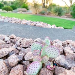
More like Whitney Mesa Recreation Area
Recommended Reviews - Whitney Mesa Recreation Area
Start your review...

Reviews With Photos - Whitney Mesa Recreation Area

One of my favorite parks in Henderson. Nestled between the mountains and communities is hidden park. In here you'll find a playground area with swings, basketball, court, hiking trails, in public bathrooms. Never mind the amazing views from the top of the park. You can catch many hiking trails off of this park from beginner to intermediate level hiking trails.

Great area to take a walk/hike. It can get hot in the summer and there is not really any shade so be aware of that if you plan on going in the warmer weather. But this is a pretty good trail with a view of the city once you get up top. There is also a bench to sit on once you reach the top if you need a little time to rest.

Hey Guys.... Trying to get into a Las Vegas hike scene when I get a chance. My work schedule, and my kids schedule is crazy and makes it hard. Which is why when I found this in the middle of Henderson I was stoked. Super convenient to get to. Middle of the LV VALLEY. This by far, isn't a strenuous hike. It's fairly easy but recommended during any season except late summer. Lol. Unless you go early morning. We went in June around 10am and finished around 11. More because we were sight seeing as we did the hike. We went up on the entrance side from Sunset. We opted to follow the trail upward initially, which menS we didn't take that first right. Taking that first right will take you on the lower half of the trail first. And mid way through you'll get yo the elevation part of the hike which can be slightly tricky. Not hard, but me having knee issues makes it a slower walk up than the average person. So, I digress, wr started the hike with the initial incline and that was easy peasy. It's a great steep walk in the incline which I believe you can go up and down for a great work out. That's more my style when I'm on work out mode. I was on having a walk and sight seeing mode this particular day. After the initial elevation we were able to walk around the top of the mesa and get great views of the valley. Beautiful views from every direction. Great areas to sit and have a breather, and a nice quiet moment with far away traffic sounds. Before doing this hike I read that someone said the airplanes were too loud but, the airplanes weren't that loud from up too and we actually loved watching and counting the planes as they came through. The hike itself offers great views, privacy, and great trail for walking running. There are definitely enough signs to warn of coyotes and snakes. We didn't see any. And for that I prob won't ever go alone LOL. But I saw several people walking or running alone. There's also signs of possible falling rocks but really, you are far enough away from them to have warning. The upper part of trail is truly top tier to the lower half. The lower half, perhaps is a great walk behind the houses for the local community wanting a quick trail. I rated the hike 5/5 stars because of its convenience, views, and length. It was about a mile and a half. But you can stretch it li get with several turnouts. As far huge difficulty. It was easy, 5/5. I'll rate a 4/5 for possible animal sightings. Take water. Wear a hat, or shades. There's no shade on this trail. Maybe take snacks for a picnic. Enjoy the views. Try and do this hike 2-4 times a year just for a good little break from everyday hustle and bustle. Oh, and BEST PART, of the hike for me, seeing the history of how much water used to exist there and was probably dried out due to drought. Sadly lots of trees drying out and surviving off the little rain the city sees. This is not a shady hike at all. Just the start and finish. But at the very end when we got back where we started we stood a second to hear the water running through the creek. A very shaded area of trees, it was beautiful to finally see a stream of running water where are all of the greenery was when you start and end the hike from Sunset. It was beautiful and I'm sure that's where all the animals, if any, we're hiding out. It was shaded and cool and the peaceful sounds of the water was the serene. I was just happy to see some water there, those trees deserve that much. Im intrigued to look up and see what it looked like decades ago in that area. I can tell it was a hub for wild life.

Cool place for a hike. You don't have to drive far out of the city for this one. It's right in the middle of civilization which is nice for reception and emergencies. There are beaten paths everywhere, pick one! There's also one that has stones on either side to keep you in the path. The rocks and gravel are loose so be careful of sliding. The view from the top of the Mesa is awesome!

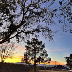
This situation we are in as a country has been interesting, but I must stay, one of the positives is that we have been going out and exploring Las Vegas in a new light. One of those ways has been with this trail. For my last job, I used to drive past this trail every day on the way to the office. Every day, I'd say to myself, "one of these days, I'm going to do that beautiful trail." This past weekend was finally the day. It was a beautiful day to finally get out of the house and enjoy some sunlight. Finding this area is pretty easy to get to. If you're coming from Stephanie, you just turn on to sunset and keep driving and eventually you'll see the small parking lot on your right hand side. On this particular day since one of the only things open right now in Las Vegas are parks and trails, that parking lot was pretty full, but that's not usually the case. I did happen to find one spot. This trail is pet friendly and you have to keep your doggy on the leash at all times, which I loved. My dog gets a little worked up when she sees other dogs, especially dogs off a leash. So I liked that they had that. They also have doggy bags for you to pick up your dog's poop, as well as trash cans to drop those bags in. Definitely appreciated that. When this hike first starts off, it goes uphill a bit. But the rest of the trail is pretty easy. We ended up walking almost 3 miles, but there's a variety of ways you can go. This trail takes you up to a cliff (pretty safe though, as there are signs everywhere telling you to not go too close to the edge), with the most spectacular views of the valley (not the Strip though). We were so taken aback at just how beautiful the views truly were. I can imagine that this hike would be great to do at sunrise or sunset, which my husband and I really do want to try one of these days. Along the trial, they also have signs everywhere with interesting facts about the wildlife. There are also some park benches where you can sit at the top to take in the views. Truly a beautiful hike. We saw people of all ages enjoying it. For people like us who aren't total "hikers," this one was relatively easy but still felt like we got a good workout in. We will definitely be back.

Lots of trash and poop everywhere. Not sure if it's all dog poop or coyote too. But it was everywhere the first .25 mi starting from the trailhead off Sunset. Other than that, very dog friendly. Mostly flat, some paved. Nice views at the top of the mesa. It was a 15 min walk to get up there.

This is a very nice walk on a trail path which goes up to the mesa top and around the perimeter and then back down a few different ways. Great view of the southeast valley. Nice lookout points with seating. A beautiful walk! Trail has an incline to get to the top, but it's not too steep or very long.

We loved this hike! It was very easy and short that it's perfect for those who just need to get out of the house and get some fresh air. There's a trail to go to the top and also one where you can ride your bike. I love how there's a little park/grass area where you can cool down and sit for a while. This was doggy approved!

The Mesa Preserve and the Mesa Recreation Park are totally different animals, but right next to each other. The rec park has a water park, tennis court, green park area and a marvelous hiking trail. There is a restroom. This trail is rated difficult for about a short, but dusty rocky steep walk. Once to the top, you're rewarded with a huge plateau of level trails and view lookouts. Bring water. No trees or shelter on this level top walking area.


Great hiking trails and scenic views of the East side of the city. The trail has been positively improved upon over the past few years. The trek is mixed terrain (desert dirt, paved, and pebble rocks) along with a few inclines, overlooks with benches, and non-marked off trails. Perfect for pets on leashes, and family-friendly "hikeability"- yeah I made it up, but it's good for most people to hike. The distance rountrip is about 2-3miles. Enjoy!

Easy hike with beautiful views. Parking is on Sunset Dr in a small parking lot. It is safe and right next to the trailhead, From the trailhead it is an easy .4 mile uphill hike to get to the top of the Mesa. From there it is flat. There are benches with view points. It is dig friendly. read more


If you're looking for a good place for a scenic walk or to do some hiking or biking, I can thoroughly recommend the Whitney Mesa Recreation Area. Located in Henderson, this is really easy to get to, with parking right on Sunset road, just be sure to look out for the entrance carefully since it is easy to miss until you know where it is. I believe there are other entrances too. The initial part of the trail is a moderate uphill climb, but nothing too difficult, and after this the trail is basically flat, being a loop with various different offshoots and overlooks, most of which have benches where you can rest and enjoy the scenery. The views of the valley really are spectacular, making this one of my favorite places to get some good outdoor exercise. The main loop is approximately 3 miles in length. In the hot months, definitely be sure to bring plenty of water and use ample sun protection because these trails have zero cover or shade. read more


Love this hike in Henderson. This hike is relatively flat. Paved and unpaved paths. You will approach some uphill walking. It's easy to follow. Beautiful views of the valley at the top of the mountain. It's about a 2.9 mile loop. Tons of benches to take a break or just enjoy the views along the trail. Great for biking, walking, or running. Tons of parking options with different trail entrances. It was the perfect day for a hike! Would highly recommend! read more


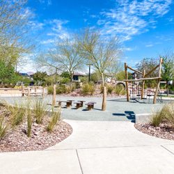
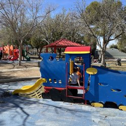
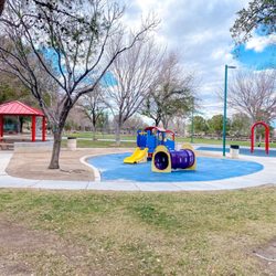
One of my favorite parks in Henderson. Nestled between the mountains and communities is hidden park. In here you'll find a playground area with swings, basketball, court, hiking trails, in public bathrooms. Never mind the amazing views from the top of the park. You can catch many hiking trails off of this park from beginner to intermediate level hiking trails. read more


3 years ago
Great area to take a walk/hike. It can get hot in the summer and there is not really any shade so be aware of that if you plan on going in the warmer weather. But this is a pretty good trail with a view of the city once you get up top. There is also a bench to sit on once you reach the top if you need a little time to rest. read more


Hey Guys.... Trying to get into a Las Vegas hike scene when I get a chance. My work schedule, and my kids schedule is crazy and makes it hard. Which is why when I found this in the middle of Henderson I was stoked. Super convenient to get to. Middle of the LV VALLEY. This by far, isn't a strenuous hike. It's fairly easy but recommended during any season except late summer. Lol. Unless you go early morning. We went in June around 10am and finished around 11. More because we were sight seeing as we did the hike. We went up on the entrance side from Sunset. We opted to follow the trail upward initially, which menS we didn't take that first right. Taking that first right will take you on the lower half of the trail first. And mid way through you'll get yo the elevation part of the hike which can be slightly tricky. Not hard, but me having knee issues makes it a slower walk up than the average person. So, I digress, wr started the hike with the initial incline and that was easy peasy. It's a great steep walk in the incline which I believe you can go up and down for a great work out. That's more my style when I'm on work out mode. I was on having a walk and sight seeing mode this particular day. After the initial elevation we were able to walk around the top of the mesa and get great views of the valley. Beautiful views from every direction. Great areas to sit and have a breather, and a nice quiet moment with far away traffic sounds. Before doing this hike I read that someone said the airplanes were too loud but, the airplanes weren't that loud from up too and we actually loved watching and counting the planes as they came through. The hike itself offers great views, privacy, and great trail for walking running. There are definitely enough signs to warn of coyotes and snakes. We didn't see any. And for that I prob won't ever go alone LOL. But I saw several people walking or running alone. There's also signs of possible falling rocks but really, you are far enough away from them to have warning. The upper part of trail is truly top tier to the lower half. The lower half, perhaps is a great walk behind the houses for the local community wanting a quick trail. I rated the hike 5/5 stars because of its convenience, views, and length. It was about a mile and a half. But you can stretch it li get with several turnouts. As far huge difficulty. It was easy, 5/5. I'll rate a 4/5 for possible animal sightings. Take water. Wear a hat, or shades. There's no shade on this trail. Maybe take snacks for a picnic. Enjoy the views. Try and do this hike 2-4 times a year just for a good little break from everyday hustle and bustle. Oh, and BEST PART, of the hike for me, seeing the history of how much water used to exist there and was probably dried out due to drought. Sadly lots of trees drying out and surviving off the little rain the city sees. This is not a shady hike at all. Just the start and finish. But at the very end when we got back where we started we stood a second to hear the water running through the creek. A very shaded area of trees, it was beautiful to finally see a stream of running water where are all of the greenery was when you start and end the hike from Sunset. It was beautiful and I'm sure that's where all the animals, if any, we're hiding out. It was shaded and cool and the peaceful sounds of the water was the serene. I was just happy to see some water there, those trees deserve that much. Im intrigued to look up and see what it looked like decades ago in that area. I can tell it was a hub for wild life. read more


Cool place for a hike. You don't have to drive far out of the city for this one. It's right in the middle of civilization which is nice for reception and emergencies. There are beaten paths everywhere, pick one! There's also one that has stones on either side to keep you in the path. The rocks and gravel are loose so be careful of sliding. The view from the top of the Mesa is awesome! read more


This situation we are in as a country has been interesting, but I must stay, one of the positives is that we have been going out and exploring Las Vegas in a new light. One of those ways has been with this trail. For my last job, I used to drive past this trail every day on the way to the office. Every day, I'd say to myself, "one of these days, I'm going to do that beautiful trail." This past weekend was finally the day. It was a beautiful day to finally get out of the house and enjoy some sunlight. Finding this area is pretty easy to get to. If you're coming from Stephanie, you just turn on to sunset and keep driving and eventually you'll see the small parking lot on your right hand side. On this particular day since one of the only things open right now in Las Vegas are parks and trails, that parking lot was pretty full, but that's not usually the case. I did happen to find one spot. This trail is pet friendly and you have to keep your doggy on the leash at all times, which I loved. My dog gets a little worked up when she sees other dogs, especially dogs off a leash. So I liked that they had that. They also have doggy bags for you to pick up your dog's poop, as well as trash cans to drop those bags in. Definitely appreciated that. When this hike first starts off, it goes uphill a bit. But the rest of the trail is pretty easy. We ended up walking almost 3 miles, but there's a variety of ways you can go. This trail takes you up to a cliff (pretty safe though, as there are signs everywhere telling you to not go too close to the edge), with the most spectacular views of the valley (not the Strip though). We were so taken aback at just how beautiful the views truly were. I can imagine that this hike would be great to do at sunrise or sunset, which my husband and I really do want to try one of these days. Along the trial, they also have signs everywhere with interesting facts about the wildlife. There are also some park benches where you can sit at the top to take in the views. Truly a beautiful hike. We saw people of all ages enjoying it. For people like us who aren't total "hikers," this one was relatively easy but still felt like we got a good workout in. We will definitely be back. read more


 - Parks Near Me - Henderson, Nevada")


5 years ago
3 years ago
Lots of trash and poop everywhere. Not sure if it's all dog poop or coyote too. But it was everywhere the first .25 mi starting from the trailhead off Sunset. Other than that, very dog friendly. Mostly flat, some paved. Nice views at the top of the mesa. It was a 15 min walk to get up there. read more

This is a very nice walk on a trail path which goes up to the mesa top and around the perimeter and then back down a few different ways. Great view of the southeast valley. Nice lookout points with seating. A beautiful walk! Trail has an incline to get to the top, but it's not too steep or very long. read more

3 years ago
6 years ago
We loved this hike! It was very easy and short that it's perfect for those who just need to get out of the house and get some fresh air. There's a trail to go to the top and also one where you can ride your bike. I love how there's a little park/grass area where you can cool down and sit for a while. This was doggy approved! read more


The Mesa Preserve and the Mesa Recreation Park are totally different animals, but right next to each other. The rec park has a water park, tennis court, green park area and a marvelous hiking trail. There is a restroom. This trail is rated difficult for about a short, but dusty rocky steep walk. Once to the top, you're rewarded with a huge plateau of level trails and view lookouts. Bring water. No trees or shelter on this level top walking area. read more


3 years ago
Very beautiful trail in the middle of Vegas! Easy hike for those not wanting anything too strenuous. Especially pretty at dusk and dawn. read more


This park is very clean and surprisingly not busy. There's a bike/walking trail. Not sure how far it goes. But there's a map that is displayed that shows details. There's a kids play area , basketball court , and a large grassy area. Well maintained. Definitely will visit here regularly read more


7 years ago
Great hiking trails and scenic views of the East side of the city. The trail has been positively improved upon over the past few years. The trek is mixed terrain (desert dirt, paved, and pebble rocks) along with a few inclines, overlooks with benches, and non-marked off trails. Perfect for pets on leashes, and family-friendly "hikeability"- yeah I made it up, but it's good for most people to hike. The distance rountrip is about 2-3miles. Enjoy! read more


very nice walking trail right off of sunset rd. we always saw the trailhead as we drove past, but never stopped. we finally decided to this evening. quite a few people walking but not crowded by any means (we went around 7:30 pm). benches throughout in case you'd like to stop/rest. also trash bins and bags for dog waste if needed. id consider this to be easy/moderate. some parts of trail are concrete but the majority is gravel. a few steep hills in the very beginning. the trail loops but we only went half way and turned around. very nice view of Henderson as this is higher up in elevation. at dusk it was so beautiful seeing all of the lights! i saw that dogs are allowed but have to be on a leash (due to cliffs presumably). read more


3 years ago
6 years ago
Perfect activity if you're visiting post-COVID Vegas and looking for something "safe" to do. Best of all, it's free! We drove about 20 mins from a restaurant in Vegas. Parking our rental was simple, easy, and free. Definitely worth the hike all the way up! The view is beautiful! But make sure you're wearing proper footwear. The path is loose gravel. Stop and take breaks as you hike up and enjoy the scenery. read more


Perfect easy getaway trail walk in Henderson. Dog friendly, easy access, easy parking. Great views of the city, (not the Strip) and surrounding mountain ranges. An easy way to get out and about, get some fresh air, have a walk & talk, get some sunshine. Easy to navigate as it's a simple out and back trail. Different options for offshoots that can take you further. A good place to take family for an easy-to-get-to outing. Trail has maps, interesting facts, is clean and well maintained, great views of the city and mountains. Some parts are paved, but most of it is gravel and there are some rock areas. Not sure if a stroller would work on rock areas. There are doggie bag dispensers and also trash receptacles at a few stops. Saw a few lizards today. Right on the flight line of incoming jets, so that's also neat to see the planes coming in, spaced apart perfectly. This is a trail you could feel comfortable going on by yourself. No creepy vibes. Great for families! Kids or adults could potentially fall off a cliff if they run off so prolly don't let them run off. Worth doing! read more


I always drive past this parking lot on Sunset and have never been curious enough to actually stop until yesterday. I finally decided to check out this hidden trailhead! Whitney Mesa is an overall nice hike for people of all ages to do. It's not a long trailhead, only 2.5 miles round trip and according to the marker in the parking lot, it's ranked easy. There are lots of informational posts throughout the hike, from beginning to end. There are also benches and trash cans located along the trail, and as previous Yelpers have said, there is no shade... Which may or may not be a problem for you! While at the top of the Mesa, you get a nice view of Henderson and the east side of the valley as well. As you make your way down, be careful as there are many small rocks that can cause you to easily lose your footing and slip. I had to give this trailhead four stars because there was just so much dang dog poop everywhere! I will never understand why people do not pick up after their pets. It's not hard to do and it clearly states on the signs that owners must clean up after their pets! Bags are even provided! C'mon people! Be courteous for other people who use the trail too! Also, there were small pieces of broken glass throughout the trail, so be extra cautious with your little ones! Happy hiking! read more


8 years ago
We have been here many times, and there are still nooks and crannies we have yet to investigate. There's a lovely little creek area just inside the trailhead. There's a nice climb, not too steep, but it does get you winded if you're an old lady like me, that rewards you with an amazing view of the valley. There's a trail that winds around the backside of the new housing development with lots of overhangs and shady places. It's a treasure right smack in the middle of the city. read more

I live right across the street from the mesa, which is awesome! Its like having it in my own back yard. I go for sunrise a lot. It features nearly panoramic mountain views, as well as a view of a lot of the valley, which is cool when the lights are on and all twinkling. It is an easy hike...a tiny tiny bit steep and it is gravel , but not scary at all. No extreme drop offs or narrow walkways. Well worth it especially if you are in the neighborhood. Its free. It only takes a few min to get up to the top. If u walk the entire thing its over two miles i think? They have mile markers. Also there r benches at neat overlooks. No shade though!!! Avoid on super hot days. Also its much windier up there than ground level. So if its a windy day, be prepared for very very strong winds up there. Highly reccommend at least once. read more

Oh what a view, will be the words you utter once you reach the top of the mesa. Looking at Whitney Mesa quickly, there is nothing special or flashy about it. I used to unknowingly pass it all the time while driving up Sunset. A little parking lot is where you start your venture. The rocky path gradually ascends and snakes it's way up the mesa.There used to be a wash and little pond , but unfortunately housing developments swallowed up that little piece of nature. It's not a very strenuous trek up before you know it , the path plateaus and your'e at the top of the mesa. The first thing you see when you reach the top is a little park bench and cemented rest/lookout area. From there you can see a beautiful panorama of the city of Henderson. The mesa stretches out for quite a long way, you can continue along it and enjoy more beautiful views from the top. read more


7 years ago
Nice hiking/biking trail in the heart of Henderson. Well maintained and clean. Pet friendly. Nice view of Henderson, benches at viewing spots. read more


6 years ago
11 years ago
There's slight elevation gain but nothing too bad even if you're not in the best shape.. To me, the new housing developments kind of throw off the nature feel to the walk/jog... a few years ago it was all desert outside of the trail and now it seems as if everything bloomed overnight. On the trail, there were a few empty bottles and a dozen clumps or dog droppings which kind of irked me. Decent walk/running trail, views could be a tad better.. this morning I explored and it looks like there are more (tougher) routes to get to some of the canyons which would probably make it more exciting. I started my walk at 5am before the sun came up and it was pretty nice watching the sun rise, trail is 1.25 miles long and depending on how early you start, you will see some lovely wildlife. read more


4 years ago
6 years ago
Whitney Mesa is a great place to do some urban hiking. While the trail is unpaved and feels fully in the desert, you never feel like you have left the city. Mostly because you can see the city around and below you for most of the hike. And this really is hiking. There is some noticeable elevation change to start your hike to the top of the mesa. It is not overly steep but its a good incline with a lot of loose gravel. This is relatively short lived and gives way to mostly level terrain. Once on top of the mesa, you get some good views of Henderson and the east side of the valley. There are a few more ups and downs along the way but nothing drastic. The biggest issue on the trail right now is some serious errosion and uneven ground due to the recent thunderstorms we've had. Use caution so you don't twist an ankle. Make your way down the 1.25 mile trail and come back to the parking lot for a solid 2.5 mile hike. The area is clean, the trail is well defined, and most of the other hikers seem friendly. This is a great way to spend a Saturday morning. read more


7 years ago
7 years ago
9 years ago
Found this gem conveniently located right off of Sunset in a residential neighborhood. The hike started off with some incline but levels out. 1.25 up makes for a nice 2.5 hike with gorgeous view of the valley. read more

Page 1 of 2
More info about Whitney Mesa Recreation Area
1760 - 1848 W Sunset Rd
Henderson, NV 89014
Directions
Hours
Indoor Amenities
Outdoor Amenities
Ask the Community - Whitney Mesa Recreation Area
Review Highlights - Whitney Mesa Recreation Area
You might also consider


Why does Yelp recommend reviews?
1 review that is not currently recommended
The reviews below are not factored into the business's overall star rating.
8 years ago
Whitney Mesa Recreation Area - parks - Updated August 2026
Best of Henderson
People found Whitney Mesa Recreation Area by searching for…
Places to Take Pictures in Henderson, NV
Beautiful Views in Henderson, NV
Recreation Centers in Henderson, NV
Scenic Overlook in Henderson, NV
Parks for Kids in Henderson, NV
Walking Trails in Henderson, NV
Hiking Trails in Henderson, NV
River Swimming in Henderson, NV
Free Things to Do in Henderson, NV
Adult Only Pools in Henderson, NV
Make Out Spot in Henderson, NV
Lakes & Ponds in Henderson, NV
Lookout Points in Henderson, NV
Trending Searches in Henderson, NV
Boardwalk near Whitney Mesa Recreation Area
Boating near Whitney Mesa Recreation Area
Cinema near Whitney Mesa Recreation Area
Cliff Jumping near Whitney Mesa Recreation Area
Cruising Spots near Whitney Mesa Recreation Area
Day Trips near Whitney Mesa Recreation Area
Dog Friendly Beaches near Whitney Mesa Recreation Area
Dog Friendly Things To Do near Whitney Mesa Recreation Area
Dog Swimming near Whitney Mesa Recreation Area
Flower Fields near Whitney Mesa Recreation Area
Free Picnic Areas near Whitney Mesa Recreation Area
Indoor Mini Golf near Whitney Mesa Recreation Area
Jet Ski Rental near Whitney Mesa Recreation Area
Kayak Rental near Whitney Mesa Recreation Area
Kids Activities Indoor near Whitney Mesa Recreation Area
Lakes near Whitney Mesa Recreation Area
Lookout Points near Whitney Mesa Recreation Area
Outdoor Activities near Whitney Mesa Recreation Area
Parks near Whitney Mesa Recreation Area
Playgrounds near Whitney Mesa Recreation Area
Public Beaches near Whitney Mesa Recreation Area
Rainy Day Activities near Whitney Mesa Recreation Area
River Swimming near Whitney Mesa Recreation Area
Rock Quarry near Whitney Mesa Recreation Area
Scenic Drive near Whitney Mesa Recreation Area
Scenic Overlook near Whitney Mesa Recreation Area
Sunrise View near Whitney Mesa Recreation Area
Surf Shop near Whitney Mesa Recreation Area
Swimming Holes near Whitney Mesa Recreation Area
Things To Do On A Rainy Day near Whitney Mesa Recreation Area
Things To Do With Kids near Whitney Mesa Recreation Area
Watch Sunset near Whitney Mesa Recreation Area
Water Parks For Kids near Whitney Mesa Recreation Area
Waterfalls And Swimming Holes near Whitney Mesa Recreation Area
Browse Articles
Browse Nearby
BEST of Henderson, Nevada Coffee near Whitney Mesa Recreation Area
BEST of Henderson, Nevada Things to Do near Whitney Mesa Recreation Area
BEST of Henderson, Nevada Restaurants near Whitney Mesa Recreation Area
BEST of Henderson, Nevada Breakfast near Whitney Mesa Recreation Area
BEST of Henderson, Nevada Playgrounds near Whitney Mesa Recreation Area
BEST of Henderson, Nevada Walking Trails near Whitney Mesa Recreation Area
BEST of Henderson, Nevada Campgrounds near Whitney Mesa Recreation Area
BEST of Henderson, Nevada Airport near Whitney Mesa Recreation Area
BEST of Henderson, Nevada Motel near Whitney Mesa Recreation Area
Browse Brands
Related Searches in Henderson, NV
Affordable Kayak Rental Services in Henderson, Nevada
Best Dog Hiking Trails Around Henderson, Nevada
Best Fishing Locations and Guides in Henderson, Nevada
Best Off Leash Dog Parks in Henderson, Nevada
Best Parks for Parties and Events in Henderson, Nevada
Best Places for Horseback Riding in Henderson, Nevada
Best Sightseeing Experiences Available in Henderson, Nevada
Best Water Parks for Kids in Henderson, Nevada
Check Out Great Playgrounds in Henderson, Nevada
Check Out Off Road Trails in Henderson, Nevada
Discover Baseball Fields Around Henderson, Nevada
Discover Dog Friendly Trails to Explore in Henderson, Nevada
Discover Fun Toddler Parks in Henderson, Nevada for Your Little One
Discover Lakes & Ponds to Explore in Henderson, Nevada
Discover Popular Bike Trails in Henderson, Nevada
Discover Scenic Mountain Bike Trails Near Henderson, Nevada
Discover Soccer Fields in Henderson, Nevada Near You
Discover Top Nature Parks to Visit in Henderson, Nevada
Discover Top State Parks to Visit in Henderson, Nevada
Discover Walking Parks in Henderson, Nevada Near You
Discover a Hiking Trail in Henderson, Nevada
Discover the Best Beaches in Henderson, Nevada
Discover the Best Kids Park Spots in Henderson, Nevada
Discover the Best Night Hike Trails in Henderson, Nevada
Dog-Friendly Hikes With Dogs in Henderson, Nevada
Enjoy Camping Adventures Around Henderson, Nevada
Enjoy Exciting Mountain Biking Adventures in Henderson, Nevada
Enjoy Kayaking Adventures in Henderson, Nevada
Enjoy Off Leash Dog Hikes in Henderson, Nevada
Enjoy Scenic Places to Walk in Henderson, Nevada
Enjoy Tent Camping Spots Around Henderson, Nevada
Enjoy a Beautiful Waterfall Hike in Henderson, Nevada
Enjoy the Best Picnic Spots and Ideas in Henderson, Nevada
Enjoy the Best Walking Path in Henderson, Nevada
Enjoy the Best Walking Trails in Henderson, Nevada
Explore Beautiful Parks and Green Spaces in Henderson, Nevada
Explore Easy Hikes Perfect for All in Henderson, Nevada
Explore Free Picnic Areas Around Henderson, Nevada
Explore Fun Activities to Do in Henderson, Nevada
Explore Parks With Pull Up Bars in Henderson, Nevada
Explore Picnic Parks Near Henderson, Nevada
Explore Popular Campgrounds Near Henderson, Nevada
Explore Popular Dog Walking Trails in Henderson, Nevada
Explore Popular Kids Parks Throughout Henderson, Nevada
Explore Popular Picnic Areas Around Henderson, Nevada
Explore Popular RV Parks Around Henderson, Nevada
Explore Scenic Lakes to Visit in Henderson, Nevada
Explore Top Dog Parks in Henderson, Nevada Near You