Bluff Trail Photos


You might also consider
More like Bluff Trail
Recommended Reviews - Bluff Trail
Start your review...

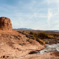
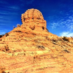
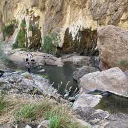
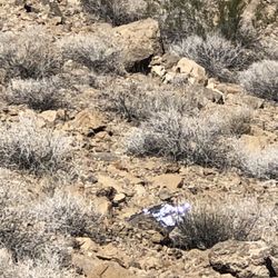
After finding this trail on Google Earth, I had to try it out. I have hiked it twice and I really like the trail. The trail is just about 3 miles round trip--out and back. There are two bluffs from which you have some great views of Lava Butte, the Las Vegas Wash, and the mountains that surround Lake Mead and the environs. To get here, come in the fee booth on Lake Mead Parkway to the Lake Mead National Recreation Area. In approximately 2 miles, turn left into Las Vegas Bay. Very shortly, a road goes off to the left. Take this road. It will lead you for about a mile to the camping area from which you'll hike. There are about 4 spaces before entering the camping area. DO NOT park in the camping area unless you want to pay the fee for camping. Walk into the camping area and turn left at the diagonal street with a #1. This takes you to a brushy area and there is a sign for the trailhead. The trail starts there and is lined by rocks for quite a distance. Along the way to the first bluff, you have a great view of the Las Vegas Wash as it winds its way to Lake Mead. You'll hear the rush of the water also. The first bluff gives you a nice overall view of the area but it's only part way. From here, the trail goes down and across the desert to the second bluff. The trail is very easy to follow. There are no side trails anywhere. Just follow the path so many have made. At the second bluff, there's a steep drop off, so just look. You can look upstream of the wash and see the weir by the Northshore Road bridge. You can also see this side of Lake Las Vegas. This is a good spot to have a snack and spend some time enjoying the great view. Retrace your steps to the parking area. As you hike out and back, keep and eye out for animals. The first time I did the trail, I saw a coyote and this time there were a lot of quail. This trail is very Covid friendly. I saw no one on the trail the first time I hiked it, and this time, there was one couple. They turned around at the first bluff so my friend and I had the trail all to ourselves. I do recommend hiking boots. There are shop lava rock you may be stepping on and the extra protection hiking boots give you is worth it. Happy Trails! read more


Easiest way to find the start of the trail is to head toward campground #74. The trail itself isn't difficult at all. Rocks outline the path to take and when the rocks disappear, you'll see the dirt path. Walked with my small dog and it was a breeze. Not much scenery, but you will encounter part of lake mead flowing which is pretty peaceful to sit and relax by :) Perfect hiking trail if you're camping in the area, but wouldn't necessarily recommend to make the drive just for this trail. There are non-camping limited parking spots available if you want to pack a lunch afterwards. When you think of the desert with nothing but direct sun rays and rocks, that is exactly what you'll get from this hike. The park map indicate the trail'a difficulty as moderate, but I'd go more with easy ! BTW: there are no dog bags in the area so pack some if you bring your dog!! read more


The Bluff Trail is a nice, short, well-marked 0.9 mile trail along the Las Vegas wash. It winds along through desert landscape on top of the bluffs looking down on the Las Vegas wash. You will often see several species of birds, including red-tailed hawks in the air and other species of bird wading in the water below. The trail is mostly flat with one climb at the end to a hill with views of Lake Las Vegas, the Las Vegas wash and the surrounding area. A good easy hike with nice views. How to Get There: The hike is in Lake Mead National Recreation Area, along Lakeshore Drive. From Las Vegas or Henderson, drive out E Lake Mead Drive past Lake Las Vegas to the north-west entrance of Lake Mead NRA. From the Las Vegas Wash entrance station, continue east on Lakeshore Rd for 2.1 miles to the Las Vegas Wash Marina turnoff. Turn left into the marina area, pass the ranger station, and immediately turn left towards the campground. You can park by the pay station at the entrance to the campground. The trail starts on the west side of the campground -- between campsites 72 and 74. The trail is well-marked with rocks and easy to find and follow. read more

More info about Bluff Trail
You might also consider


Bluff Trail - hiking - Updated July 2026
Best of Boulder City,
People found Bluff Trail by searching for…
Beaches in Boulder City,, Nevada
Campgrounds in Boulder City,, Nevada
Sand Dunes in Boulder City,, Nevada
Lookout Points in Boulder City,, Nevada
Waterfalls and Swimming Holes in Boulder City,, Nevada
Scenic Drive in Boulder City,, Nevada
Fishing Spots in Boulder City,, Nevada
Star Gazing in Boulder City,, Nevada
Bird Sanctuary in Boulder City,, Nevada
Hiking Trails With Waterfalls in Boulder City,, Nevada
Parks in Boulder City,, Nevada
Beautiful Views in Boulder City,, Nevada
Meteor Shower in Boulder City,, Nevada
Natural Hot Springs in Boulder City,, Nevada
Things to Do in Boulder City,, Nevada
Rock Quarry in Boulder City,, Nevada
Tent Camping in Boulder City,, Nevada
Easy Hikes in Boulder City,, Nevada
Rattlesnake in Boulder City,, Nevada
Dog Friendly Hiking Trails in Boulder City,, Nevada
Sunbathing in Boulder City,, Nevada
Secret Spots in Boulder City,, Nevada
People who viewed Bluff Trail also viewed
Clark County Wetlands Wells Trailhead
2 reviews
White Owl Canyon
23 reviews
Clark County Wetlands Pabco Trailhead
12 reviews
Sloan Canyon National Conservation Area
44 reviews
Nevada Power Trail
4 reviews
Anthem East Trail
21 reviews
Paseo Verde Trail
12 reviews
Park Peak Trail 403
4 reviews
Inspirada Overlook
4 reviews
Sacred Places
1 review