Anthem East Trail Photos


You might also consider
More like Anthem East Trail
Recommended Reviews - Anthem East Trail
Start your review...

Reviews With Photos

This trail is great if you are getting back into hiking, and since I have some physical issues that need to be worked out, it's a fairly easy grade. I also appreciate greatly the generous amounts of benches or rock seating that we encountered. Bring your hiking sticks with pavement attachments as the trail section we were on was paved with asphalt. Watch out for the biking community that also uses this. I love the idea that within a few minutes drive I can really be "outdoors" and away from the traffic and noise. Great views too. At the park where you enter they also have restrooms to use before and after. While we still have cool weather, bring something to break the wind, as wind chill will make it feel colder. I also bring earplugs or pop in earbuds as the rush of wind is a problem in my ears (or use a hat or head band). As it gets warmer, remember to layer and use sunscreen as there are no shady areas.

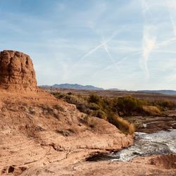
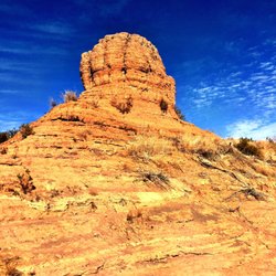
OMG, this has to be one of the BEST trails in all of Vegas! I don't know why there is so little review of this place. This is pretty much all you need to know: *The address here gets you across the school, walk or drive up to baseball diamond number 1. That's where the hike starts. Ample parking and bathrooms here is cleaner also than the one by field #2 and #3. *The hike starts out windy paved roads with benches every other turn or so. Then left onto the unpaved road, look for the marker. *The elevation here is slight. I would rate this hike easy to moderate easy. *The view isn't a wow, but still a nice view on a clear day. *The best part of this hike is it's clean. Like super clean and let's keep it that way okay? *There is no shade anywhere on this hike, so plan accordingly. *Be on the lookout for bikers, runners, and other hikers. *People wearing masks are 50/50. Which for Vegas is pretty darn good odds. And we did takeout and ate at the park below. A perfect day to be able to eat and walk it off. Will definitely be back to take more pictures and walk some more!

Perfect for the new, slow, and recovering walker, with an extremely low grade constant incline, followed by a gentle downhill once you turn around. Easy on the knees and hips, with plenty of spots to sit and recover (benches every 200-300 feet). Best in the morning, as it will be scorching midday. Parking is plentiful and safe -- security persons monitor who comes in and out. It's at the eastern side of the valley, so would be delightful for sunrise walks. There are also bike trails which seem to be popular with the more adventurous mountain biking approach!

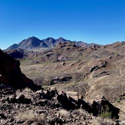
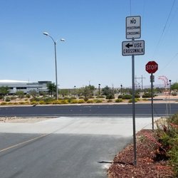
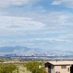
Pretty easy to get to. Go on Eastern heading towards Anthem, left on Reunion Dr and the parking lot is Field #1. The first part of the trail is easy since you're winding up the trail all on pavement roads. There's benches if anybody in your party need to take a break. Got some good views of the city and flowers, plants and cactus. But keep heading up for a better view. It's about a 1/2 mile hiking up the pavement trail. Once you see nothing but dirt and loose gravels, that's when the trail/hike gets a bit more challenging. The incline gets steep and watch your footings. These loose rocks are no joke! I think it's about 2 miles up to the top point (black rock) for a really good view of the city. Keep hiking up past the radio/tv towers to get there. But there's so many different paths to take....you can go exploring if you're up for it. We passed by a lot of cyclists as well as people hiking with their big dogs. Don't bring your small dog here....this isn't the trail for them. As usual, use common sense and wear sensible footwear. Hiking shoes aren't needed but don't get wearing your vans or chuck taylors up here. You need something with arch and ankle support and good traction. I'm TERRIFIED of snakes and there were signs warning you of those nasty little fu*kers but thank goodness I didn't see any. Saw a few lizards and little things flying around. Good ol COVID-19 is making me do things I don't normally do. HIKING. But hey...it's good exercise, you're outdoors getting some fresh air, got some nice views going on all while still maintaining social distancing. Is this going to be the new norm now?

I enjoyed this beautiful trail. 1. No hiking shoes necessary 2. You can jog this trail 3. A good long trail with side roads so stick to the path! 4. Sunscreen/hats necessary 5. T-mobile service was available the whole time 6. I didn't finish but was on the trail for 1 hour. Enjoyed the nature & the views. 7. Not red rock, but living 5 minutes away so excited to bring my future doggie here 8. Benches for rest and snackies:)

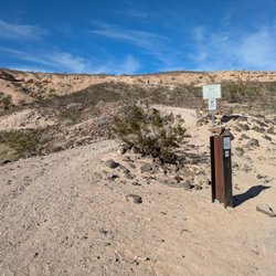
Super easy trails and a great way to work off some Mole Fries from Taco Y Taco. If you're thinking about hiking as an outdoors hobby or form of exercise, this is a great place to start. Anthem East Trails has very manageable inclines that you can bike, walk, or even use for horseback riding. Which I thought this was pretty unsual considering this hiking spot is in the suburbs. PRO TIP: Bring water and lookout for Rattle Snakes. I noticed multiple signs warning hikers of these scaly and deadly noise makers.

I have used this trail twice as the gateway for hiking. I have hiked to the peak of Black Mountain and today I used the trail as my gateway to hike to Park's Peak, a shorter and less rigorous hike than the Black Mountain one. The parking area could have been larger and I'm not sure if street parking is allowed. I was second in the lot this morning, so parking was not an issue and I saw several cars parked on the street. I looked for signs as I was leaving the area, but I saw none that were about parking. I probably would rate this trail with more than 3 stars if I used more of it than just the short distance until you get to the Sloan Canyon NCA. Maybe I need to do more exploring in that area.

Currently training for a 5k race that's coming up next month and I decided to hit up Anthem East Trail over by Del Webb Middle School. I've hiked this trail a couple times before with my fam and it's been a long time since I've been back. The weather is finally cool enough for me to take walks outside again and I like that. With the record breaking heat that we had over the summer, it was just too hot to go for a walk outside. My favorite part about hiking these trails is that I get to enjoy the amazing views of the mountains, The Strip, and all other parts of the Las Vegas valley while I get my steps in. Dogs can tag along with you, but be aware that coyotes and rattlesnakes are very active along this trail. Also be sure to carry plenty of water and fully charged phone just in case. I hiked solo and didn't want to go way far out on the trail, so I just stayed where I could see all the views of the city. But I managed to reach my goal of 3.5 miles! read more


3 years ago
This trail is great if you are getting back into hiking, and since I have some physical issues that need to be worked out, it's a fairly easy grade. I also appreciate greatly the generous amounts of benches or rock seating that we encountered. Bring your hiking sticks with pavement attachments as the trail section we were on was paved with asphalt. Watch out for the biking community that also uses this. I love the idea that within a few minutes drive I can really be "outdoors" and away from the traffic and noise. Great views too. At the park where you enter they also have restrooms to use before and after. While we still have cool weather, bring something to break the wind, as wind chill will make it feel colder. I also bring earplugs or pop in earbuds as the rush of wind is a problem in my ears (or use a hat or head band). As it gets warmer, remember to layer and use sunscreen as there are no shady areas. read more


1 year ago
OMG, this has to be one of the BEST trails in all of Vegas! I don't know why there is so little review of this place. This is pretty much all you need to know: *The address here gets you across the school, walk or drive up to baseball diamond number 1. That's where the hike starts. Ample parking and bathrooms here is cleaner also than the one by field #2 and #3. *The hike starts out windy paved roads with benches every other turn or so. Then left onto the unpaved road, look for the marker. *The elevation here is slight. I would rate this hike easy to moderate easy. *The view isn't a wow, but still a nice view on a clear day. *The best part of this hike is it's clean. Like super clean and let's keep it that way okay? *There is no shade anywhere on this hike, so plan accordingly. *Be on the lookout for bikers, runners, and other hikers. *People wearing masks are 50/50. Which for Vegas is pretty darn good odds. And we did takeout and ate at the park below. A perfect day to be able to eat and walk it off. Will definitely be back to take more pictures and walk some more! read more

3 years ago
Perfect for the new, slow, and recovering walker, with an extremely low grade constant incline, followed by a gentle downhill once you turn around. Easy on the knees and hips, with plenty of spots to sit and recover (benches every 200-300 feet). Best in the morning, as it will be scorching midday. Parking is plentiful and safe -- security persons monitor who comes in and out. It's at the eastern side of the valley, so would be delightful for sunrise walks. There are also bike trails which seem to be popular with the more adventurous mountain biking approach! read more
6 years ago
Pretty easy to get to. Go on Eastern heading towards Anthem, left on Reunion Dr and the parking lot is Field #1. The first part of the trail is easy since you're winding up the trail all on pavement roads. There's benches if anybody in your party need to take a break. Got some good views of the city and flowers, plants and cactus. But keep heading up for a better view. It's about a 1/2 mile hiking up the pavement trail. Once you see nothing but dirt and loose gravels, that's when the trail/hike gets a bit more challenging. The incline gets steep and watch your footings. These loose rocks are no joke! I think it's about 2 miles up to the top point (black rock) for a really good view of the city. Keep hiking up past the radio/tv towers to get there. But there's so many different paths to take....you can go exploring if you're up for it. We passed by a lot of cyclists as well as people hiking with their big dogs. Don't bring your small dog here....this isn't the trail for them. As usual, use common sense and wear sensible footwear. Hiking shoes aren't needed but don't get wearing your vans or chuck taylors up here. You need something with arch and ankle support and good traction. I'm TERRIFIED of snakes and there were signs warning you of those nasty little fu*kers but thank goodness I didn't see any. Saw a few lizards and little things flying around. Good ol COVID-19 is making me do things I don't normally do. HIKING. But hey...it's good exercise, you're outdoors getting some fresh air, got some nice views going on all while still maintaining social distancing. Is this going to be the new norm now? read more


4 years ago
I enjoyed this beautiful trail. 1. No hiking shoes necessary 2. You can jog this trail 3. A good long trail with side roads so stick to the path! 4. Sunscreen/hats necessary 5. T-mobile service was available the whole time 6. I didn't finish but was on the trail for 1 hour. Enjoyed the nature & the views. 7. Not red rock, but living 5 minutes away so excited to bring my future doggie here 8. Benches for rest and snackies:) read more


3 years ago
Super easy trails and a great way to work off some Mole Fries from Taco Y Taco. If you're thinking about hiking as an outdoors hobby or form of exercise, this is a great place to start. Anthem East Trails has very manageable inclines that you can bike, walk, or even use for horseback riding. Which I thought this was pretty unsual considering this hiking spot is in the suburbs. PRO TIP: Bring water and lookout for Rattle Snakes. I noticed multiple signs warning hikers of these scaly and deadly noise makers. read more


3 years ago
I have used this trail twice as the gateway for hiking. I have hiked to the peak of Black Mountain and today I used the trail as my gateway to hike to Park's Peak, a shorter and less rigorous hike than the Black Mountain one. The parking area could have been larger and I'm not sure if street parking is allowed. I was second in the lot this morning, so parking was not an issue and I saw several cars parked on the street. I looked for signs as I was leaving the area, but I saw none that were about parking. I probably would rate this trail with more than 3 stars if I used more of it than just the short distance until you get to the Sloan Canyon NCA. Maybe I need to do more exploring in that area. read more

7 years ago
11 years ago
Wow wow WOW this place is a hidden gem considering it took me two & a half years to find it! It has everything I could want in a park like long, uphill jogging trails, AMAZING views (bring your camera!), and the freshest air in the city ... Oh yea, and free parking =D read more


10 years ago
9 years ago
13 years ago
More info about Anthem East Trail
2256 Reunion Dr
Henderson, NV 89052
Directions
(702) 267-4000
Call Now
Hours
Outdoor Amenities
Ask the Community - Anthem East Trail
Review Highlights - Anthem East Trail
You might also consider


Anthem East Trail - hiking - Updated May 2026
Best of Henderson
People found Anthem East Trail by searching for…
Scenic Views in Henderson, Nevada
Walking Trails in Henderson, Nevada
Lookout Points in Henderson, Nevada
Hiking Trails in Henderson, Nevada
Scenic Overlook in Henderson, Nevada
Places to Take Pictures in Henderson, Nevada
Beautiful Views in Henderson, Nevada
Flower Fields in Henderson, Nevada
Easy Hikes in Henderson, Nevada
Running Trails in Henderson, Nevada
Scenic Drive in Henderson, Nevada
Bike Paths in Henderson, Nevada
Dog Friendly Hiking Trails in Henderson, Nevada
Things to Do in Henderson, Nevada
Jogging Trails in Henderson, Nevada
Watch Sunset in Henderson, Nevada
Off Road Trails in Henderson, Nevada
Mountain Biking in Henderson, Nevada
Places to Walk Around in Henderson, Nevada
Running Routes in Henderson, Nevada
Trending Searches in Henderson, NV
Boat Rental near Anthem East Trail
Botanical Gardens near Anthem East Trail
Bounce House Rentals near Anthem East Trail
Campgrounds near Anthem East Trail
Cheap Plants near Anthem East Trail
Cliff Jumping near Anthem East Trail
Floral Designers near Anthem East Trail
Flower Fields near Anthem East Trail
Flower Shop near Anthem East Trail
Garage Sales near Anthem East Trail
Garden Center near Anthem East Trail
Lakes & Ponds near Anthem East Trail
Nurseries & Gardening near Anthem East Trail
Outdoor Activities near Anthem East Trail
Outdoor Furniture Stores near Anthem East Trail
Party Equipment Rentals near Anthem East Trail
Pedicure near Anthem East Trail
Photo Spots near Anthem East Trail
Picnic Areas near Anthem East Trail
Places To Take Pictures near Anthem East Trail
Rock Quarry near Anthem East Trail
Running Trails near Anthem East Trail
Rv Rental near Anthem East Trail
Scenic Drive near Anthem East Trail
Sunrise View near Anthem East Trail
Swimming Holes near Anthem East Trail
Table And Chair Rentals near Anthem East Trail
Browse Articles
Browse Nearby
BEST of Henderson, Nevada Restaurants near Anthem East Trail
BEST of Henderson, Nevada Coffee near Anthem East Trail
BEST of Henderson, Nevada Things to Do near Anthem East Trail
BEST of Henderson, Nevada Parks near Anthem East Trail
BEST of Henderson, Nevada Breakfast near Anthem East Trail
Browse Brands
Related Searches in Henderson, NV
Affordable Kayak Rental Services in Henderson, Nevada
Best Fishing Locations and Guides in Henderson, Nevada
Best Nature Trails for Hiking in Henderson, Nevada
Best Places for Horseback Riding in Henderson, Nevada
Check Out Off Road Trails in Henderson, Nevada
Discover Dog Friendly Trails to Explore in Henderson, Nevada
Discover Scenic Mountain Bike Trails Near Henderson, Nevada
Discover Scenic Walking Paths in Henderson, Nevada
Discover Top Nature Parks to Visit in Henderson, Nevada
Discover Walking Parks in Henderson, Nevada Near You
Discover a Hiking Trail in Henderson, Nevada
Discover the Best Night Hike Trails in Henderson, Nevada
Discover the Best Running Track in Henderson, Nevada
Dog-Friendly Hikes With Dogs in Henderson, Nevada
Enjoy Camping Adventures Around Henderson, Nevada
Enjoy Exciting Mountain Biking Adventures in Henderson, Nevada
Enjoy Kayaking Adventures in Henderson, Nevada
Enjoy Tent Camping Spots Around Henderson, Nevada
Enjoy a Scenic Walk in Henderson, Nevada
Enjoy the Best Walking Trails in Henderson, Nevada
Exciting Cliff Jumping Spots in Henderson, Nevada
Explore Beautiful Parks and Green Spaces in Henderson, Nevada
Explore Easy Hikes Perfect for All in Henderson, Nevada
Explore Fun Activities to Do in Henderson, Nevada
Explore Popular Campgrounds Near Henderson, Nevada
Explore the Best Beach Spots in Henderson, Nevada
Explore the Best Boating Spots in Henderson, Nevada
Explore the Best Swimming Holes Around Henderson, Nevada
Explore the Best Trail Options in Henderson, Nevada
Family Friendly Hiking With Kids in Henderson, Nevada
Find Beautiful Views in Henderson, Nevada
Find Popular Ziplining Spots Around Henderson, Nevada
Find the Best Parks for Picnics in Henderson, Nevada
Find the Best Scenic View Locations in Henderson, Nevada
Hiking Trails With Waterfalls in Henderson, Nevada
Off Leash Dog Hiking Trails in Henderson, Nevada
Plan a Scenic Drive Route Near Henderson, Nevada
Popular Fishing Spots to Explore in Henderson, Nevada
Popular Outdoor Activities to Try in Henderson, Nevada
Popular Picnic Spots to Visit in Henderson, Nevada
Safe River Swimming Areas in Henderson, Nevada
Safe and Fun Parks for Kids in Henderson, Nevada
Top Climbing Spots and Gyms in Henderson, Nevada
Top Paddleboarding Activities in Henderson, Nevada
Top Running Trails to Explore in Henderson, Nevada
Top Swimming Lakes to Enjoy in Henderson, Nevada
Top Swimming Spots and Pools in Henderson, Nevada
Top Things to Do With Kids in Henderson, Nevada