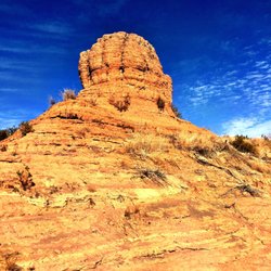
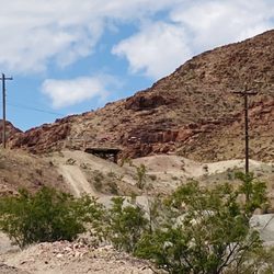
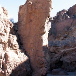
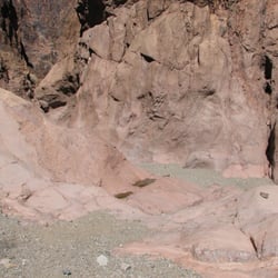
White Owl Canyon Photos


You might also consider
More like White Owl Canyon
Recommended Reviews - White Owl Canyon
Start your review...

Reviews With Photos

This was a fun hike. We went on a Saturday morning around 9am. It begins with a downhill trail and follow the rock pathway. You go through some canyons and there's a big tunnel. It is fairly easy to moderate. There were some shells along the way that the kids enjoyed looking at. Total loop is 2.2 miles round trip. We did not see any owls unfortunately.

Nov 22, 2020 - 3.5 miles Loop Trail - 1.5hrs to complete Dog Friendly, there was only one spot that had a high drop but there was a rock the pup was able to jump on then jump down from. After you walk out of the double tunnels, climb out up the dirt hill directly to the right of them (as you come out) to the abandoned road to stay on the loop trail. (Go left on the road to stay on the trail. Your left when you are facing the lake) As other reviewers said the hardest part was the climb out at the very end where we started for sure! It is pretty steep so you get that booty burn it but it's all worth it!

There are two things I look for when It comes to pick up a trail: 1st, it has to be interesting or scenic 2nd, it's short (less than 6 miles round trip) This trail was rated "Moderate" and it's short (2.2 miles round trip) with 300 feet elevation change. I would think the ONLY "moderate" part of this trail is the steep 45ft slope which was hard on the knees. Coming down was easy, coming up, I made at least 3 stops:XD As everyone had already mentioned how to find the trailhead and where the trail leads to. I am not going to repeat it. Perhaps, I didn't do enough homework, I was a little confused at some point about which way to turn left. If that ever happened, follow your instinct, and follow the footprints! I made to the first culvert (tunnel) and it was starting to get dark. I had to turn on the light to make sure nothing follows me:p The trail isn't heavily trafficked on weekdays, only bumped into a group of 3 on my way into the slot canyon. It was quiet and peaceful. No cellular reception down in the slot canyon but Verizon has good coverage in most of the Lake Mead Recreation Area. Entrance fee $25 They accept America the Beautiful Annual Pass! I went to Lake Mead back to back, it started to grow on me as it's not as far as Death Valley and less crowded as Red Rock Canyon.


What a beautiful hike! As someone who is not as fit as they'd like to be, I was still able to tackle this fairly easily. Be warned that you have to go up a very steep and gravely hill at the end of the loop to get back to the parking lot. I was more than a little bit winded after that. I'd recommend downloading a map of the trail off the internet before starting this loop. I have Verizon, and I lost service during the middle of my hike. This trail doesn't have the best signage, so it's good to be prepared. Overall, I'd say this trail is fairly beginner friendly if you don't have any medical issues. Do not expect easy paved paths, but there's nothing super challenging to climb over either.

The trail isn't easy to follow as mentioned by others and a good 3.5 mile round trip hike that took us about 3.5 hours to complete. You turn right and make your way up the hill almost immediately after the second tunnel and see the red rocks on uiur left! The alltrails app makes it super easy to follow the trail. Thankfully a nice person using the trail could show us our progress on the hike! Not very much vegetation, but there are beautiful formations and views of the wash as it makes its way to Lake Mead. Plus, owl sightings!!

Very beautiful hike that's not too much of an effort. Great for kids and out of shape hikers like me. The trailhead isn't marked but it's pretty obvious where the trail starts. In case you don't see it, it's around the second (middle) picnic bench. You have to go down a very steep hill that has pretty loose gravel. This is the most "moderate" park of the hike. Once you get into the slot canyon, it's very easy to ambulate. Some small obstacles but not many. There are many shaded areas if you decide to go during the summer like I did. It was 9am but it was still pretty darn hot. The culverts are an interesting portion of this hike. It is a bit dark inside the longer (first) one but I didn't use a light and was able to see pretty well. And believe me I was looking. Snake + solo hike = no bueno. I didn't follow the advice to loop around, I just turned around where you could loop around after the second set of culverts [this will be pretty obvious too because it the only section that looks kind of like a ramp on the left side (SE) facing away from the culverts] because I wanted to walk through that slot canyon again. As of 6//17/18, the entrance fee to Lake Mead was $25 for 7 days. However, if you live here like I do and you think you'll come more than once, it's probably best to get the $45 all year pass.

Love this hike! Super easy and lots of shade once you get to the canyons. Had to ask where the path was, got lost the first time. Basically: go down the hill, walk straight, go over the small hill and take the left path. Trail was clean and it was neat seeing all the seashells on the floor! There is an entrance fee but when I went (before 6am), the office wasn't open yet so we were able to pass without paying. (I have an America beautiful pass which they take as well) The passed 2 times I went (August 2020), I barely saw anyone. Basically had the trail to myself the entire time I was there. Would recommend leaving around 10/11am before it gets really hot and making sure you have enough water for when you have to climb up the steep hill from the beginning! You will need it!

Whoooooooo **owl tone** knew that this hike was here -- I sure as heck didn't. When you think of hiking at Lake Mead, I always thought just the railroad trail or the Hoover Dam. Nope, there's more than meets the eye. After pay $20 for the Lake Mead Park fees, we to a short scenic drive to a parking lot overlooking what looked like a mini Horseshoe Bend. We parked the car and proceeded to walk (tread) our way down a loose dirt/gravel/rock trail. Following our hiking leads, we walked through the dry river bed that was Lake Mead. We knew this because of all the sea shells that laid on the ground we walked upon. After walking an easy 15 minutes, we came upon a slot canyon ---- we know how much I love slot canyons -- the only slots I like to play in **hehe**lame joke*** These canyons were easily as high as the ones in Antelope Canyon but, wider to let in more light. As we walked along the way, our friends pointed out various owl nests -- hence, white owl canyon. It was kinda crazy and creepy to think that there were owls above us; especially considering the owl droppings along the wall. Yuck. After walking through the slots, it lead us to a man made tunnel, which goes under the roads of Lake Mead State Park. And another tunnel past that. Throughout this 30-45 minute hike, sadly, we weren't lucky enough to see an owls. But, so happy to have seen this hike on a beautiful sunday funday.

Over the last 8 years, I have hiked this canyon probably 15 or more times. I do it as a loop starting at the parking area at 33 Hole along Lakeshore Road at Lake Mead. As you enter the 33 Hole area, turn left at the first side road and go to that parking area. There's a bathroom along the way in and a picnic table close to where you park. From the picnic table, take the steep trail down the hill. Go across the bottom where Lake Mead used to be and cross over a small ridge. After that ridge, turn left following the trail up the wash into White Owl Canyon. From here, you'll go through two sets of drainage pipes under the new and old roads that go along the lake's shoreline. In between, you'll pass through a meandering slot canyon of layered mud hardened and formed by water over thousands of years. Always keep your eyes both toward the top of the canyon and along the bottom. On the top, we often see an owl who'll be watching us as we near a nesting area. On the bottom of the wash, look for owl pellets--the bones and fur of animals the owls have eaten and then regurgitated. They cannot eat again until they rid themselves of this waste. As you look up, you'll also see some areas where the owls have nested over the years. I always do this hike as a loop. After the second tunnel, I climb out of the wash to the old road and walk that north for about a mile before following another wash that leads back through a tunnel and connects with the Lakeshore Trail and then follow that back to the steep hill to the car. Over the years, I've seen the lake's water level drop and ride--but mostly drop--until now the one area is totally dry. It's sad to see how the level has dropped and the egrets and heron are no longer near the trail. I find this to be a relaxing time with nature and it's a hike I've done by myself when I want to be alone and enjoy in a very quiet way.

Finding it is difficult because it is not on any map or kiosk. The best way to find the trailhead is to ask a ranger when arriving into Lake Mead Rec area. We were there mid afternoon in January and the weather was great. This area is partially shaded so on a chilly day be sure to bring a layer for the canyon itself. Path was clear once you arrived in the actual canyon. The path travels along what used to be a water way and is littered with shells making for a very interesting sight. The slot canyon is the nesting place for owls, however on our visit we did not see any. There are several areas which look prime for those wanting to adventure and scramble on the rocky terrain however for those just seeking a hike it is also perfect! There are two areas which you walk under the roadways through large tunnels. These are very dark so I recommend a light to make sure you don't stumble upon any undesirable critters. It was a fun path for us (2 adults and 1 child) and for those wanting a path a little less traveled it is a must!!

This is a great scenic hike. Would be fun for families. We took dogs with us today. Usually not a hike I would take dogs. However time of day and so many people didn't think we would see any owls. We seen lots of owl poo up high on the ledges. I've yet to see an owl on my hikes here. Have seen friends photos and there is the poo so they are there. Last time I was here I seen an owl's regurgitation with bones in it (mice maybe). Next time we're gonna go early in the morning. I'm determined to see one!

Not too far from the (paid) NPS Henderson entrance is this moderate 2-3+ mile (you choose) trail that starts right off the parking lot. Shaded picnic areas and rudimentary restrooms are at both nearby 33 Hole parking lots. The first (and last!) hill warrants good hiking footwear and your attention. Uneven and unmaintained so find a map online for best results. Bring water, bring Fido, dress for the weather and pack out your trash. The views and slot canyon are worth it! read more


This hike is unpaved, and someone can easily get lost. There were times when I had no idea where I was going, and luckily, the navigation on here told me I was going the wrong way. The hike, in general, is excellent. You see a little river, go under tunnels, and hike up a small hill. There is enough nature to look around rather than just dirt and rocks because we are in a desert. Not too many people around either, which is nice, that it isn't too crowded. Unfortunately, I did not see any owls. Lastly, you do have to pay an entrance fee to come inside, I believe it was 20. Overall, the hike was easy, and I would come back. read more


2 years ago
The start of the trailhead had a sign marker stating that it was the trail and that this trail is unmaintained (I was actually surprised there was a start to trail marker since I knew ahead of time it wasn't a maintained trail). I enjoyed the hike. I recommend using All Trails for a trail map as there are a few times you are faced with the uncertainty of knowing which way to go as there are no signs on the trail. The trail itself isn't all that hard (it was rated moderate on All Trails) and there are a few parts where you go up hill, but nothing too crazy, A lot of the trail is in direct sun so plan accordingly. I enjoyed seeing the canyon exploring the rock formations. Plus, since its an unmaintained trail it is pretty quiet and does get some foot traffic but not a ton. There are many seashells on the trail so you can see where water used to be--neat! A nice spot to hike for a few hours (you go less than 4 miles roundtrip). read more


1 year ago
This was a fun hike. We went on a Saturday morning around 9am. It begins with a downhill trail and follow the rock pathway. You go through some canyons and there's a big tunnel. It is fairly easy to moderate. There were some shells along the way that the kids enjoyed looking at. Total loop is 2.2 miles round trip. We did not see any owls unfortunately. read more


5 years ago
Nov 22, 2020 - 3.5 miles Loop Trail - 1.5hrs to complete Dog Friendly, there was only one spot that had a high drop but there was a rock the pup was able to jump on then jump down from. After you walk out of the double tunnels, climb out up the dirt hill directly to the right of them (as you come out) to the abandoned road to stay on the loop trail. (Go left on the road to stay on the trail. Your left when you are facing the lake) As other reviewers said the hardest part was the climb out at the very end where we started for sure! It is pretty steep so you get that booty burn it but it's all worth it! read more


There are two things I look for when It comes to pick up a trail: 1st, it has to be interesting or scenic 2nd, it's short (less than 6 miles round trip) This trail was rated "Moderate" and it's short (2.2 miles round trip) with 300 feet elevation change. I would think the ONLY "moderate" part of this trail is the steep 45ft slope which was hard on the knees. Coming down was easy, coming up, I made at least 3 stops:XD As everyone had already mentioned how to find the trailhead and where the trail leads to. I am not going to repeat it. Perhaps, I didn't do enough homework, I was a little confused at some point about which way to turn left. If that ever happened, follow your instinct, and follow the footprints! I made to the first culvert (tunnel) and it was starting to get dark. I had to turn on the light to make sure nothing follows me:p The trail isn't heavily trafficked on weekdays, only bumped into a group of 3 on my way into the slot canyon. It was quiet and peaceful. No cellular reception down in the slot canyon but Verizon has good coverage in most of the Lake Mead Recreation Area. Entrance fee $25 They accept America the Beautiful Annual Pass! I went to Lake Mead back to back, it started to grow on me as it's not as far as Death Valley and less crowded as Red Rock Canyon. read more


 - Hiking Near Me - Boulder City, Nevada")

 starts behind this sign - Hiking Near Me - Boulder City, Nevada")


Really gorgeous hike and it has lots of different scenery and variations. It is quite easy just one rock you have to get off but I sit down and jumped off it was easy. Lots of shade, the tunnels are cool. The rock formations are gorgeous. Far views and many photo ops. It took us 1.5h. read more


4 years ago
Nice hike in the Lake Mead area. Not much flora to see, but the slot canyons are pretty cool! Beginning of the trail from the parking lot is pretty steep but the remainder of the trail is pretty flat. read more


5 years ago
What a beautiful hike! As someone who is not as fit as they'd like to be, I was still able to tackle this fairly easily. Be warned that you have to go up a very steep and gravely hill at the end of the loop to get back to the parking lot. I was more than a little bit winded after that. I'd recommend downloading a map of the trail off the internet before starting this loop. I have Verizon, and I lost service during the middle of my hike. This trail doesn't have the best signage, so it's good to be prepared. Overall, I'd say this trail is fairly beginner friendly if you don't have any medical issues. Do not expect easy paved paths, but there's nothing super challenging to climb over either. read more


3 years ago
The trail isn't easy to follow as mentioned by others and a good 3.5 mile round trip hike that took us about 3.5 hours to complete. You turn right and make your way up the hill almost immediately after the second tunnel and see the red rocks on uiur left! The alltrails app makes it super easy to follow the trail. Thankfully a nice person using the trail could show us our progress on the hike! Not very much vegetation, but there are beautiful formations and views of the wash as it makes its way to Lake Mead. Plus, owl sightings!! read more


8 years ago
Very beautiful hike that's not too much of an effort. Great for kids and out of shape hikers like me. The trailhead isn't marked but it's pretty obvious where the trail starts. In case you don't see it, it's around the second (middle) picnic bench. You have to go down a very steep hill that has pretty loose gravel. This is the most "moderate" park of the hike. Once you get into the slot canyon, it's very easy to ambulate. Some small obstacles but not many. There are many shaded areas if you decide to go during the summer like I did. It was 9am but it was still pretty darn hot. The culverts are an interesting portion of this hike. It is a bit dark inside the longer (first) one but I didn't use a light and was able to see pretty well. And believe me I was looking. Snake + solo hike = no bueno. I didn't follow the advice to loop around, I just turned around where you could loop around after the second set of culverts [this will be pretty obvious too because it the only section that looks kind of like a ramp on the left side (SE) facing away from the culverts] because I wanted to walk through that slot canyon again. As of 6//17/18, the entrance fee to Lake Mead was $25 for 7 days. However, if you live here like I do and you think you'll come more than once, it's probably best to get the $45 all year pass. read more


6 years ago
Love this hike! Super easy and lots of shade once you get to the canyons. Had to ask where the path was, got lost the first time. Basically: go down the hill, walk straight, go over the small hill and take the left path. Trail was clean and it was neat seeing all the seashells on the floor! There is an entrance fee but when I went (before 6am), the office wasn't open yet so we were able to pass without paying. (I have an America beautiful pass which they take as well) The passed 2 times I went (August 2020), I barely saw anyone. Basically had the trail to myself the entire time I was there. Would recommend leaving around 10/11am before it gets really hot and making sure you have enough water for when you have to climb up the steep hill from the beginning! You will need it! read more


Whoooooooo **owl tone** knew that this hike was here -- I sure as heck didn't. When you think of hiking at Lake Mead, I always thought just the railroad trail or the Hoover Dam. Nope, there's more than meets the eye. After pay $20 for the Lake Mead Park fees, we to a short scenic drive to a parking lot overlooking what looked like a mini Horseshoe Bend. We parked the car and proceeded to walk (tread) our way down a loose dirt/gravel/rock trail. Following our hiking leads, we walked through the dry river bed that was Lake Mead. We knew this because of all the sea shells that laid on the ground we walked upon. After walking an easy 15 minutes, we came upon a slot canyon ---- we know how much I love slot canyons -- the only slots I like to play in **hehe**lame joke*** These canyons were easily as high as the ones in Antelope Canyon but, wider to let in more light. As we walked along the way, our friends pointed out various owl nests -- hence, white owl canyon. It was kinda crazy and creepy to think that there were owls above us; especially considering the owl droppings along the wall. Yuck. After walking through the slots, it lead us to a man made tunnel, which goes under the roads of Lake Mead State Park. And another tunnel past that. Throughout this 30-45 minute hike, sadly, we weren't lucky enough to see an owls. But, so happy to have seen this hike on a beautiful sunday funday. read more


Over the last 8 years, I have hiked this canyon probably 15 or more times. I do it as a loop starting at the parking area at 33 Hole along Lakeshore Road at Lake Mead. As you enter the 33 Hole area, turn left at the first side road and go to that parking area. There's a bathroom along the way in and a picnic table close to where you park. From the picnic table, take the steep trail down the hill. Go across the bottom where Lake Mead used to be and cross over a small ridge. After that ridge, turn left following the trail up the wash into White Owl Canyon. From here, you'll go through two sets of drainage pipes under the new and old roads that go along the lake's shoreline. In between, you'll pass through a meandering slot canyon of layered mud hardened and formed by water over thousands of years. Always keep your eyes both toward the top of the canyon and along the bottom. On the top, we often see an owl who'll be watching us as we near a nesting area. On the bottom of the wash, look for owl pellets--the bones and fur of animals the owls have eaten and then regurgitated. They cannot eat again until they rid themselves of this waste. As you look up, you'll also see some areas where the owls have nested over the years. I always do this hike as a loop. After the second tunnel, I climb out of the wash to the old road and walk that north for about a mile before following another wash that leads back through a tunnel and connects with the Lakeshore Trail and then follow that back to the steep hill to the car. Over the years, I've seen the lake's water level drop and ride--but mostly drop--until now the one area is totally dry. It's sad to see how the level has dropped and the egrets and heron are no longer near the trail. I find this to be a relaxing time with nature and it's a hike I've done by myself when I want to be alone and enjoy in a very quiet way. read more


8 years ago
Finding it is difficult because it is not on any map or kiosk. The best way to find the trailhead is to ask a ranger when arriving into Lake Mead Rec area. We were there mid afternoon in January and the weather was great. This area is partially shaded so on a chilly day be sure to bring a layer for the canyon itself. Path was clear once you arrived in the actual canyon. The path travels along what used to be a water way and is littered with shells making for a very interesting sight. The slot canyon is the nesting place for owls, however on our visit we did not see any. There are several areas which look prime for those wanting to adventure and scramble on the rocky terrain however for those just seeking a hike it is also perfect! There are two areas which you walk under the roadways through large tunnels. These are very dark so I recommend a light to make sure you don't stumble upon any undesirable critters. It was a fun path for us (2 adults and 1 child) and for those wanting a path a little less traveled it is a must!! read more


This is a great scenic hike. Would be fun for families. We took dogs with us today. Usually not a hike I would take dogs. However time of day and so many people didn't think we would see any owls. We seen lots of owl poo up high on the ledges. I've yet to see an owl on my hikes here. Have seen friends photos and there is the poo so they are there. Last time I was here I seen an owl's regurgitation with bones in it (mice maybe). Next time we're gonna go early in the morning. I'm determined to see one! read more


White Owl Canyon is a short slot canyon at Lake Mead known for its population of barn owls. It is located along Lakeshore Drive in Lake Mead National Recreation Area, about 30 minutes southeast of Las Vegas. This hike follows the shoreline of Lake Mead. This hike is ideal for newer hikers looking to push themselves, or advanced hikers looking to explore somewhere new and actually have time to enjoy the beautiful scenery. As we entered the slot canyon, I was 'wowed'. The canyon was named for the white owls (Barn Owls) that live in the canyon. We didn't see owl today but saw crows and "white wash" (owl poop) on the rock walls. Watch the ground for pellets, oblong clumps of bone and fur which is owl barf. The total time to complete for us was 2 hours. read more


6 years ago
6 years ago
8 years ago
I've hiked here twice and have yet to see an owl, although in some areas there's an incredible amount of their poop on the walls. It's a very pleasant hike although there are some steep parts and rarely climbing up or down is necessary. The rocks are very sharp in this area so gloves are nice. From the parking spot, it's a short hike to Lake Mead. On my two trips to this spot there were pelicans, hawks, and blue herons around. read more


9 years ago
More info about White Owl Canyon
Ask the Community - White Owl Canyon
Review Highlights - White Owl Canyon
You might also consider


White Owl Canyon - hiking - Updated May 2026
Best of Boulder City
People found White Owl Canyon by searching for…
Scenic Views in Boulder City, NV
Scenic Drive in Boulder City, NV
Scenic Overlook in Boulder City, NV
Beautiful Views in Boulder City, NV
Natural Hot Springs in Boulder City, NV
Dinosaur Park in Boulder City, NV
Easy Hikes in Boulder City, NV
Hiking Trails in Boulder City, NV
Walking Trails in Boulder City, NV
Places to Take Pictures in Boulder City, NV
Dog Friendly Hiking Trails in Boulder City, NV
Waterfalls and Swimming Holes in Boulder City, NV
Cliff Jumping in Boulder City, NV
Parks for Kids in Boulder City, NV
Sand Dunes in Boulder City, NV
Things to Do With Kids in Boulder City, NV
Star Gazing in Boulder City, NV
Picnic Spots in Boulder City, NV
Visitor Centers in Boulder City, NV
Fun Things to Do in Boulder City, NV
Trending Searches in Boulder City, NV
Botanical Gardens near White Owl Canyon
Bounce House Rentals near White Owl Canyon
Campgrounds near White Owl Canyon
Cheap Plants near White Owl Canyon
Cliff Jumping near White Owl Canyon
Dog Friendly Things To Do near White Owl Canyon
Flower Fields near White Owl Canyon
Flower Shop near White Owl Canyon
Garage Sales near White Owl Canyon
Garden Center near White Owl Canyon
Graduation Leis near White Owl Canyon
Lakes & Ponds near White Owl Canyon
Nurseries & Gardening near White Owl Canyon
Outdoor Activities near White Owl Canyon
Outdoor Furniture Stores near White Owl Canyon
Party Equipment Rentals near White Owl Canyon
Pedicure near White Owl Canyon
Photo Spots near White Owl Canyon
Picnic Areas near White Owl Canyon
Places To Take Pictures near White Owl Canyon
Rock Quarry near White Owl Canyon
Running Trails near White Owl Canyon
Rv Rental near White Owl Canyon
Spray Tanning near White Owl Canyon
Sunrise View near White Owl Canyon
Swimming Holes near White Owl Canyon
Table And Chair Rentals near White Owl Canyon
Browse Nearby
Browse Brands
Related Searches in Boulder City, NV
Affordable Kayak Rental Services in Boulder City, Nevada
Best Fishing Locations and Guides in Boulder City, Nevada
Best Places for Horseback Riding in Boulder City, Nevada
Best Waterfalls and Swimming Holes in Boulder City, Nevada
Check Out Off Road Trails in Boulder City, Nevada
Discover Dog Friendly Trails to Explore in Boulder City, Nevada
Discover Scenic Mountain Bike Trails Near Boulder City, Nevada
Discover Top Nature Parks to Visit in Boulder City, Nevada
Discover a Hiking Trail in Boulder City, Nevada
Discover the Best Night Hike Trails in Boulder City, Nevada
Discover the Best Running Track in Boulder City, Nevada
Dog-Friendly Hikes With Dogs in Boulder City, Nevada
Enjoy Camping Adventures Around Boulder City, Nevada
Enjoy Exciting Mountain Biking Adventures in Boulder City, Nevada
Enjoy Kayaking Adventures in Boulder City, Nevada
Enjoy Tent Camping Spots Around Boulder City, Nevada
Enjoy the Best Walking Path in Boulder City, Nevada
Enjoy the Best Walking Trails in Boulder City, Nevada
Exciting Cliff Jumping Spots in Boulder City, Nevada
Explore Beautiful Parks and Green Spaces in Boulder City, Nevada
Explore Easy Hikes Perfect for All in Boulder City, Nevada
Explore Fun Activities to Do in Boulder City, Nevada
Explore Popular Campgrounds Near Boulder City, Nevada
Explore Top Dog Parks in Boulder City, Nevada Near You
Explore the Best Beach Spots in Boulder City, Nevada
Explore the Best Boating Spots in Boulder City, Nevada
Explore the Best Trail Options in Boulder City, Nevada
Find Beautiful Views in Boulder City, Nevada
Find Cozy Camping Cabins in Boulder City, Nevada
Find Parks and Recreation Activities in Boulder City, Nevada
Find Popular Ziplining Spots Around Boulder City, Nevada
Find the Best Parks for Picnics in Boulder City, Nevada
Find the Best Scenic View Locations in Boulder City, Nevada
Great Places to Walk in Boulder City, Nevada
Hiking Trails With Waterfalls in Boulder City, Nevada
Off Leash Dog Hiking Trails in Boulder City, Nevada
Plan a Scenic Drive Route Near Boulder City, Nevada
Popular Fishing Spots to Explore in Boulder City, Nevada
Popular Outdoor Activities to Try in Boulder City, Nevada
Popular Picnic Spots to Visit in Boulder City, Nevada
Safe River Swimming Areas in Boulder City, Nevada
Safe and Fun Parks for Kids in Boulder City, Nevada
Top Climbing Spots and Gyms in Boulder City, Nevada
Top Paddleboarding Activities in Boulder City, Nevada
Top Running Trails to Explore in Boulder City, Nevada
Top Swimming Lakes to Enjoy in Boulder City, Nevada
Top Swimming Spots and Pools in Boulder City, Nevada
Top Things to Do With Kids in Boulder City, Nevada