McCullough Hills Trail Photos

 - Hiking Near Me")


You might also consider
More like McCullough Hills Trail
Recommended Reviews - McCullough Hills Trail
Start your review...

Reviews With Photos


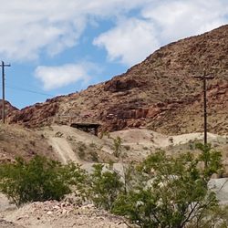
So finally decided do true TRAIL run session and my friends that do trail running all the time told me McCullough Hills is good one. Me more of road runner training for triathlons or marathons. I understand the benefits of trail running higher elevation, more climbing, and solid workout on the legs. I needed do 10miles on the training schedule. The way trails set up for first timer nice and easy five miles out and back. They have few trails that can mix things up add more difficulty and really once at top just another spectacular view of the valley. The one I did was the main path out towards anthem hills (it complete opposite end but either side has base starting point for the trails). Or you can do Sloan Canyon trail from the base of McCullough. So really there no way can get bored with the routes from climbing or distance. One thing make sure pay attention depending on the time of the year and day. The trail has snakes. So be conscious of them. The paths especially the main ones nice and wide so whether someone on bike, running, or hiking enough room pass. It such popular trail everyone respects it and keep it clean. At the base really like the clean area with bathrooms, map of couple of the trails, rules of the trails, water fountain, and one picnic table with cover so once done can chill in the shade. Warning the address on this is WAY WAY off. I ended up driving around neighborhood with no end in sight. Forget the direction. The true address 271-289 W Mission Dr. Henderson, NV 89044. If looking to take break from Vegas not looking for long drive. McCullough Hills Trails is the perfect spot for training, relaxing, and once get top the views is amazing.

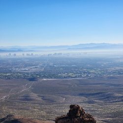
This is the actual hike I went on today. I accidently checked in for the wrong place. Located at the end of Mission off Horizon Ridge Pkwy, just up the hill from the big shopping center on Horizon/Horizon Ridge. This is a popular trail, we saw plenty of hikers and bikers, dog walkers, and even some families out for a hike. You can actually take this trail all the way over to Anthem (8 miles). Not much for views, at least where we walked to (mile marker 2). Its your typical Vegas hike, lots of desert bushes, no wildlife, and not much to look at. I do miss hiking in Oregon. I did this hike with the Henderson Hikers meetup group. There were about 8 of us and it was good to have some encouragement as I never realize how out of shape I am. Too much binge watching TV I guess, and drinking, and smoking, and just being OLD! lol My goal for 2016 is to get out and hike as much as possible, 3-5 times a week, to get back into shape.

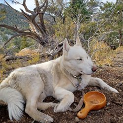
My favorite trail in Henderson. Parks are good for a short walk but if you really want to hike & get closer to nature this is the spot. The trail itself stretches 8 miles from Henderson to the anthems. If you stay on the path the terrain is pretty mild. Mountain bike riders usually are polite and warn you if they are approaching or need to get by. You can see a lot of wildlife at dawn & dusk. They have recently added a well lit parking area, bathrooms and shaded area with picnic tables. There's not much vandalism, a few idiots leave some broken bottles and such but nothing serious. What's great about this trail is that it's not very crowded. So if you want some solitude up in the hills check this place out.

My advice is to know the trail you're going to hike before you go. Don't be like us and assume you will know where to go. We started on one trail and we're supposed to go off on another but I didn't realize that until I got home and saw the directions. SO, we ended up hiking and walking and walking and hiking further and further into the desert. Ended up doubling the original hike that was "supposed" to be a loop. Other than getting lost, it was a nice trail. It's not strenuous at all and pretty easy with a few hills. Nothing unbearable or too hard, even for kids. There's lots of cactus plants and of corse rocks and wildlife. It's nice to go early in the morning before it gets too hot. There are some views of the city and lots of views of desert and mountains. At the beginning of the hike there is a parking lot, restrooms and maps. read more


4 years ago
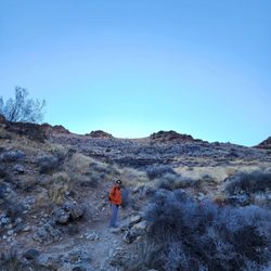
Came here this morning on a Saturday around 7 AM. Parking lot was nearly empty. I hiked around the trails here for a few hours until it started getting more crowded and noisier. A lot of people in Henderson talk too loudly when they are outside, and they let their children scream nonsensically. The trails are a great workout for your core. I could really feel the burn in my leg muscles as I hiked these hills. The crispness of the morning crosswinds felt more intense the higher I cimbed. It felt really good to hike. Obviously this isn't as fun as going to Lake Mead, but it'll do if you need a quick morning hike before work. read more


From beginner trails to I'm dying, dead, deceased trails. My friends tried to take me on the latter, but I wasn't having it, lol. Great spots for climbing, but watch out for the elevation if you're not used to it. All in all a nice place to get out and about! read more


So finally decided do true TRAIL run session and my friends that do trail running all the time told me McCullough Hills is good one. Me more of road runner training for triathlons or marathons. I understand the benefits of trail running higher elevation, more climbing, and solid workout on the legs. I needed do 10miles on the training schedule. The way trails set up for first timer nice and easy five miles out and back. They have few trails that can mix things up add more difficulty and really once at top just another spectacular view of the valley. The one I did was the main path out towards anthem hills (it complete opposite end but either side has base starting point for the trails). Or you can do Sloan Canyon trail from the base of McCullough. So really there no way can get bored with the routes from climbing or distance. One thing make sure pay attention depending on the time of the year and day. The trail has snakes. So be conscious of them. The paths especially the main ones nice and wide so whether someone on bike, running, or hiking enough room pass. It such popular trail everyone respects it and keep it clean. At the base really like the clean area with bathrooms, map of couple of the trails, rules of the trails, water fountain, and one picnic table with cover so once done can chill in the shade. Warning the address on this is WAY WAY off. I ended up driving around neighborhood with no end in sight. Forget the direction. The true address 271-289 W Mission Dr. Henderson, NV 89044. If looking to take break from Vegas not looking for long drive. McCullough Hills Trails is the perfect spot for training, relaxing, and once get top the views is amazing. read more


This is the actual hike I went on today. I accidently checked in for the wrong place. Located at the end of Mission off Horizon Ridge Pkwy, just up the hill from the big shopping center on Horizon/Horizon Ridge. This is a popular trail, we saw plenty of hikers and bikers, dog walkers, and even some families out for a hike. You can actually take this trail all the way over to Anthem (8 miles). Not much for views, at least where we walked to (mile marker 2). Its your typical Vegas hike, lots of desert bushes, no wildlife, and not much to look at. I do miss hiking in Oregon. I did this hike with the Henderson Hikers meetup group. There were about 8 of us and it was good to have some encouragement as I never realize how out of shape I am. Too much binge watching TV I guess, and drinking, and smoking, and just being OLD! lol My goal for 2016 is to get out and hike as much as possible, 3-5 times a week, to get back into shape. read more


My favorite trail in Henderson. Parks are good for a short walk but if you really want to hike & get closer to nature this is the spot. The trail itself stretches 8 miles from Henderson to the anthems. If you stay on the path the terrain is pretty mild. Mountain bike riders usually are polite and warn you if they are approaching or need to get by. You can see a lot of wildlife at dawn & dusk. They have recently added a well lit parking area, bathrooms and shaded area with picnic tables. There's not much vandalism, a few idiots leave some broken bottles and such but nothing serious. What's great about this trail is that it's not very crowded. So if you want some solitude up in the hills check this place out. read more


Had a few hours to blow so decided to stop here for some hiking as it was close by. The trailhead and parking lot were easy to find and clean facilities. The trail was a nice easy walking trail with a few smaller hills. Would hike here anytime. read more


10 years ago
11 years ago
More info about McCullough Hills Trail
Henderson, NV 89002
Directions
(702) 267-4000
Call Now
Hours
Outdoor Amenities
Ask the Community - McCullough Hills Trail
Review Highlights - McCullough Hills Trail
You might also consider


McCullough Hills Trail - hiking - Updated May 2026
Best of Henderson
People found McCullough Hills Trail by searching for…
Scenic Overlook in Henderson, NV
Walking Trails in Henderson, NV
Hiking Trails in Henderson, NV
Urban Exploration in Henderson, NV
Lakes & Ponds in Henderson, NV
Off Road Trails in Henderson, NV
Electric Bike Shop in Henderson, NV
Lookout Points in Henderson, NV
Running Routes in Henderson, NV
Running Trails in Henderson, NV
Hiking Groups in Henderson, NV
Trending Searches in Henderson, NV
Bird Sanctuary near McCullough Hills Trail
Botanical Gardens near McCullough Hills Trail
Bounce House Rentals near McCullough Hills Trail
Campgrounds near McCullough Hills Trail
Cliff Jumping near McCullough Hills Trail
Dog Friendly Trails near McCullough Hills Trail
Flower Fields near McCullough Hills Trail
Flower Shop near McCullough Hills Trail
Free Picnic Areas near McCullough Hills Trail
Garage Sales near McCullough Hills Trail
Garden Center near McCullough Hills Trail
Hiking near McCullough Hills Trail
Lakes & Ponds near McCullough Hills Trail
Lookout Points near McCullough Hills Trail
Mens Suits near McCullough Hills Trail
Nurseries & Gardening near McCullough Hills Trail
Outdoor Activities near McCullough Hills Trail
Outdoor Furniture Stores near McCullough Hills Trail
Parks near McCullough Hills Trail
Party Equipment Rentals near McCullough Hills Trail
Pedicure near McCullough Hills Trail
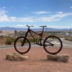
Photo Spots near McCullough Hills Trail
Pick Your Own Farms near McCullough Hills Trail
Picnic Areas near McCullough Hills Trail
Places To Take Pictures near McCullough Hills Trail
Plant Nursery near McCullough Hills Trail
River Swimming near McCullough Hills Trail
Rock Quarry near McCullough Hills Trail
Running Trails near McCullough Hills Trail
Scenic Night View near McCullough Hills Trail
Secluded Spots near McCullough Hills Trail
Star Gazing near McCullough Hills Trail
Strawberry Picking near McCullough Hills Trail
Sunset View near McCullough Hills Trail
Table And Chair Rentals near McCullough Hills Trail
Walking Trails near McCullough Hills Trail
Browse Nearby
BEST of Henderson, Nevada Coffee near McCullough Hills Trail
BEST of Henderson, Nevada Things to Do near McCullough Hills Trail
BEST of Henderson, Nevada Restaurants near McCullough Hills Trail
BEST of Henderson, Nevada Parks near McCullough Hills Trail
BEST of Henderson, Nevada Breakfast near McCullough Hills Trail
BEST of Henderson, Nevada Lakes near McCullough Hills Trail
BEST of Henderson, Nevada Hotels near McCullough Hills Trail
Browse Brands
Related Searches in Henderson, NV
Affordable Bike Repair Services in Henderson, Nevada
Affordable Bike Tune Up Services in Henderson, Nevada
Affordable Kayak Rental Services in Henderson, Nevada
Affordable Mobile Bike Repair in Henderson, Nevada
Best Electric Bike Rental Services in Henderson, Nevada
Best Fishing Locations and Guides in Henderson, Nevada
Best Nature Trails for Hiking in Henderson, Nevada
Best Places for Horseback Riding in Henderson, Nevada
Best Used Bikes for Sale Near Henderson, Nevada
Check Out Off Road Trails in Henderson, Nevada
Discover Dog Friendly Trails to Explore in Henderson, Nevada
Discover Popular Bike Tours in Henderson, Nevada
Discover Popular Bike Trails in Henderson, Nevada
Discover Scenic Bike Paths in Henderson, Nevada
Discover Scenic Mountain Bike Trails Near Henderson, Nevada
Discover Scenic Walking Paths in Henderson, Nevada
Discover Top Nature Parks to Visit in Henderson, Nevada
Discover Walking Parks in Henderson, Nevada Near You
Discover a Hiking Trail in Henderson, Nevada
Discover the Best Night Hike Trails in Henderson, Nevada
Discover the Best Running Track in Henderson, Nevada
Dog-Friendly Hikes With Dogs in Henderson, Nevada
Enjoy Biking Adventures Around Henderson, Nevada
Enjoy Camping Adventures Around Henderson, Nevada
Enjoy Exciting Mountain Biking Adventures in Henderson, Nevada
Enjoy Hiking Adventures in Henderson, Nevada
Enjoy Kayaking Adventures in Henderson, Nevada
Enjoy Tent Camping Spots Around Henderson, Nevada
Enjoy a Scenic Walk in Henderson, Nevada
Enjoy the Best Tubing Experiences in Henderson, Nevada
Enjoy the Best Walking Trails in Henderson, Nevada
Exciting Cliff Jumping Spots in Henderson, Nevada
Experience the Thrill of Road Bike Rental in Henderson, Nevada
Explore BMX Bike Shops Near Henderson, Nevada
Explore Beautiful Parks and Green Spaces in Henderson, Nevada
Explore Bike Rentals Throughout Henderson, Nevada
Explore Easy Hikes Perfect for All in Henderson, Nevada
Explore Electric Bikes Available in Henderson, Nevada
Explore Fun Activities to Do in Henderson, Nevada
Explore Popular Campgrounds Near Henderson, Nevada
Explore Popular Scenic Overlook Points in Henderson, Nevada
Explore Scenic Lakes to Visit in Henderson, Nevada
Explore Secret Spots Worth Visiting in Henderson, Nevada
Explore the Best Beach Spots in Henderson, Nevada
Explore the Best Boating Spots in Henderson, Nevada
Explore the Best Swimming Holes Around Henderson, Nevada
Explore the Best Trail Options in Henderson, Nevada
Family Friendly Hiking With Kids in Henderson, Nevada
Browse Articles
People who viewed McCullough Hills Trail also viewed
Union Pacific Railroad Trail
10 reviews
Park Peak Trail 403
4 reviews
Liberty Bell Arch
22 reviews
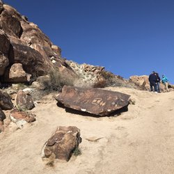
Petroglyph Trail
4 reviews
I-215 East Beltway Trail
2 reviews
Southeast
Lake Las Vegas Overlook
2 reviews
Cactus Wren Trail
2 reviews
Clark County Wetlands Pabco Trailhead
12 reviews
Paseo Verde Trail
12 reviews
Lake Mead Parkway Trail
2 reviews