St. Rose Parkway Trail Photos


You might also consider
More like St. Rose Parkway Trail
Recommended Reviews - St. Rose Parkway Trail
Start your review...

Reviews With Photos

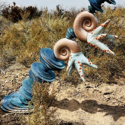
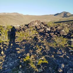
When I saw Tracy P.'s check-in and read her review, I knew that I wanted to do this "hike". I like rabbits in general, so when I saw photos of the Tortoise and the Hare, I was even more motivated to exercise during my vacation on the "9th Hawaiian Island". Tracy & I met for the first time on the top level of the M Resort's parking garage. She was as cheerful and energetic in person as she is onlline! I'm really gald I went with her, because she had great ideas on where to park and is an excellent conversationalist and tour guide. I'm happy that we started at the beginning of the Trail because I felt that I didn't miss anything. Seeing things in a photograph vs. seeing it in real life is so different. Up close, I was amazed at how the benches, the rest stops, and the sculptures are created - using thick wire as the frame and rocks/cement stones inside the frame. The desert, in the cool morning, was so vast and beautiful...I truly enjoyed the novelty and colors of the sandy environment and cactus since I'm surrounded by tropical shrubs and climate at home in Hawaii. I enjoyed the Mile Markers along the way and the informational signs that described the various wildlife that inhabit the area. It's a well-done, flat trail with a map at the beginning that shows the options for your day's journey. Our fellow walkers were all nice & friendly! I would walk this trail again for sure with my visor, water bottle, and walking partner! Mahalo to Tracy for a wonderful experience!!

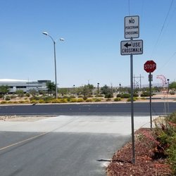
My main goal today was to ride this trail. When I'be been in the area, I've seen the trail and I thought I'd bring my bike and park in the M Resort's garage and then bike the trail. Instead, I changed my plans and biked two other trails to reach this trail. I rode from Seven Hills Drive west to the trailhead and then rode it back to the Cactus Wren Park and then to the Cactus Wren Trail for the way back to my parked car. This trail is really nicely done! There are interpretive markers showing the animals of the desert you might see along the trail. There are also a number of sculptures with these animals. There are several streets that go off to the south, but since this area is not growing right now, you can easily cross those streets with ease. I agree with the other posters that there should be some kind of bridge over Eastern Avenue. Although I didn't have any trouble crossing, I used the crossing lights and I was alert to drivers as I did. I must say I saw several very courteous drivers who held back on their right turns to let me cross. One things Henderson needs to do is mark the trails better. Periodically there's a map of the trails near one of the entrances. They use a color code which is often misleading because there are shades of the same color and it makes it difficult to distinguish one trail from the next. This is an ideal walk or ride for a family. I saw many out today enjoying the warm November weather and the day off from school.

2016 Yelp 100 Review Challenge - 25/100 Some may say you're boring but I say you're peaceful. St. Rose Trail is the way to go if you're looking to get in a good cardio session without distractions. If I want to clear my head and go for a run, this is where I go. Almost always, it's never crowded. During the summer months, most people run or ride during the early morning or late afternoons. I love that they finally built a traffic light at the Maryland & St Rose intersection! Finally! Because now we don't have to walk all the way to Seven Hills drive or worry about getting hit by on going traffic. Funny thing about this trail, once in a while I'll run into a drunk/high homeless man that says the most random things! So funny! I haven't seen him lately, but when I did he was raving about 7 Eleven. haha. The trail is smooth asphalt, just the way I like it. There are mile markers and sculptures of the local wildlife (turtle, hare, coyotes, roadrunner) coming from the M Resort end. Around the St. Rose Hospital area, there are more sculptures. There's also descriptions of the wildlife in the area and benches along the trail. I've seen a few coyotes but they never bothered us. I think they're more afraid of us humans than we are to them. There was a great view of the mountains, but now that they're building houses to the south of the trail the mountain views will be no more. There is a bridge on the Pecos end of the trail. I wish they would build a bridge on the west end of the trail. That would be nice. *** TIP: Great parking spots at the Starbucks near Seven Hills & St Rose pkwy OR if you want to start at the M Resort end, there's a few parking stalls at the gas station.

5 years ago
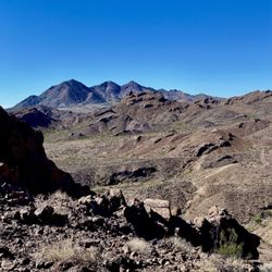
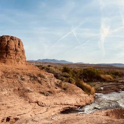
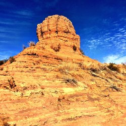
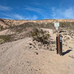
This time of year makes exercising outdoors during the daytime a must! Enjoy the crisp air and sun against your cheek along this 8.1 miles stretch of asphalt and concrete. To keep things interesting out here in the desert, look out for a couple of artistic animal duo structures: the Tortoise & the Hare and Wile E. Coyote & the Road Runner. This trail is not quite a straight shot. There are several major crosswalks/intersections where you'll need to stop and press the crosswalk button. Nevertheless, it's a pretty safe and flat course. If need to take a break, there are several shaded benches, and many smaller uncovered ones made of granite along the way. Plenty of pet waste stations, too. The St Rose Parkway Trail is great multi-use trail, such as biking, running, walking, and inline skating, and is also wheelchair accessible. The trail serves as a connection to 12 different parks and other trailheads, all managed by the City of Henderson Parks and Recreation Dept. Other than the trail itself, what I like most about this path are the businesses conveniently located off of the trail, like Starbucks! Also, it's neat to see this area grow with new and upcoming stores like Hobby Lobby and In-N-Out! The starting point (Mile 0) is near M casino, the south end of St. Rose Pkwy. It terminates just before I-215. There are many places to park off of St Rose Pkwy. But, the published places are Siena Heights Trailhead (2570 Siena Heights Drive) and Cactus Wren Park (2900 Ivanpah Drive) for restrooms and parking. Get outdoors now before it gets too hot in the summer! read more
! - Hiking Near Me - Henderson, Nevada")


 - Hiking Near Me - Henderson, Nevada")


Pavement under my Nikes, butterflies roam free surrounding me. Every time I make contact with the pavement the balance grows every constantly inside me! This beautiful trail has markers that indicate when it's time to go. The starting line uses the fairy tale the Tortoise and the Hare as a whimsical way to roam and explore. You can run, run, run as the hare did and finish in a flash, or pace yourself such as the wise tortoise did. After you get started down the trail look along the way for information booths that mention about the wildlife that calls this area home. The best rich flavors of flora and fauna along this four miles breathtaking. The views of the mountains on the other side of the interstate 15 just rise up to meet the sky. As the sun sets on these mountains every day the next morning the sun shines and stretches her rays across the desert floor to rise and meet the day. Butterflies constantly fly around me as I run on the pavement. Their renewals of hope and happiness continue to fill me with hope that their presence brings joy. As I continue to transform the butterflies presence inspires me to trust that all is going to be coming up rainbows and butterflies. The delicate wings of the butterfly as it flutters close so delicate. That ever present tipping in nature that with all the beauty around us we are all guests that share this wonderful place together. Up close to a butterfly as I bend down to admire its beauty. The wings flutter on air up and down. Looking at the butterfly oh so close she closes her wings and blends into the concrete. The Royal monarch of this butterfly goes white as she disguises herself from me. I would never capture the wild monarch she is truly wild and free. As she delivers her message of hope and divine happiness I leave knowing that I have witnessed a message from beyond. Answers come in all meanings, butterflies have been known to be the messengers of fairies and angels to deliver these messages. Henderson, NV is the lovely city that wants "you" to go outside. Log those 10,000 steps a day. Get that heart healthy. These created paths are low impact to the eco system surrounding it. The creatures that call this area home are still safe with their habitat not too engrossed on. "Leave nature as you found it." While this created path was a beautiful addition that starts at the M Hotel and Casino it circles around and ends at St. Rose Hospital. A four mile trek with wildlife and trash bins all along the path. Make sure the wild coyotes stay here, and those cute little bunnies do not end up as your pet. They are truly cute and cuddly from afar, could pose a risk if you get too close to them. Your empty water bottles and trail mix bags deposit those in these trash bins as needed. Please be careful playing in the desert, she is unrelenting and surreal. Drink plenty of water and enjoy your created paved bliss. Deep within our psyche is this abyss that holds all of our dreams and passions. This liquid pool needs revival once in awhile. We are meant to be in tune with nature. Nurture that bond once in a while with the wild wonderful beautiful surrounding us. Go outside! Unplug your headphones and run on that pavement with the noises of nature surrounding you as you are part of its cycle. The balance of being in tune with nature, for it is our cycle of being. It's the reasons for why, and all of our doubts. Know sometimes we have to embrace the universe accept its gifts and enjoy its happiness that it has planned for you. Once in a while these gears need to be fixed and honed to make sure that it's functional. Run, jump, leap and enjoy this big whole wide world. "Look deep into nature, and then you will understand everything better." Albert Einstein. A man whom had ultimate fame, beautiful mind, and such strength seeks such simplicity with our world. We could truly learn a lot. Open your mind, see the world through another's eyes and go outside! read more


3 years ago
When I saw Tracy P.'s check-in and read her review, I knew that I wanted to do this "hike". I like rabbits in general, so when I saw photos of the Tortoise and the Hare, I was even more motivated to exercise during my vacation on the "9th Hawaiian Island". Tracy & I met for the first time on the top level of the M Resort's parking garage. She was as cheerful and energetic in person as she is onlline! I'm really gald I went with her, because she had great ideas on where to park and is an excellent conversationalist and tour guide. I'm happy that we started at the beginning of the Trail because I felt that I didn't miss anything. Seeing things in a photograph vs. seeing it in real life is so different. Up close, I was amazed at how the benches, the rest stops, and the sculptures are created - using thick wire as the frame and rocks/cement stones inside the frame. The desert, in the cool morning, was so vast and beautiful...I truly enjoyed the novelty and colors of the sandy environment and cactus since I'm surrounded by tropical shrubs and climate at home in Hawaii. I enjoyed the Mile Markers along the way and the informational signs that described the various wildlife that inhabit the area. It's a well-done, flat trail with a map at the beginning that shows the options for your day's journey. Our fellow walkers were all nice & friendly! I would walk this trail again for sure with my visor, water bottle, and walking partner! Mahalo to Tracy for a wonderful experience!! read more


My main goal today was to ride this trail. When I'be been in the area, I've seen the trail and I thought I'd bring my bike and park in the M Resort's garage and then bike the trail. Instead, I changed my plans and biked two other trails to reach this trail. I rode from Seven Hills Drive west to the trailhead and then rode it back to the Cactus Wren Park and then to the Cactus Wren Trail for the way back to my parked car. This trail is really nicely done! There are interpretive markers showing the animals of the desert you might see along the trail. There are also a number of sculptures with these animals. There are several streets that go off to the south, but since this area is not growing right now, you can easily cross those streets with ease. I agree with the other posters that there should be some kind of bridge over Eastern Avenue. Although I didn't have any trouble crossing, I used the crossing lights and I was alert to drivers as I did. I must say I saw several very courteous drivers who held back on their right turns to let me cross. One things Henderson needs to do is mark the trails better. Periodically there's a map of the trails near one of the entrances. They use a color code which is often misleading because there are shades of the same color and it makes it difficult to distinguish one trail from the next. This is an ideal walk or ride for a family. I saw many out today enjoying the warm November weather and the day off from school. read more


10 years ago
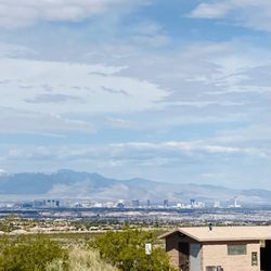
2016 Yelp 100 Review Challenge - 25/100 Some may say you're boring but I say you're peaceful. St. Rose Trail is the way to go if you're looking to get in a good cardio session without distractions. If I want to clear my head and go for a run, this is where I go. Almost always, it's never crowded. During the summer months, most people run or ride during the early morning or late afternoons. I love that they finally built a traffic light at the Maryland & St Rose intersection! Finally! Because now we don't have to walk all the way to Seven Hills drive or worry about getting hit by on going traffic. Funny thing about this trail, once in a while I'll run into a drunk/high homeless man that says the most random things! So funny! I haven't seen him lately, but when I did he was raving about 7 Eleven. haha. The trail is smooth asphalt, just the way I like it. There are mile markers and sculptures of the local wildlife (turtle, hare, coyotes, roadrunner) coming from the M Resort end. Around the St. Rose Hospital area, there are more sculptures. There's also descriptions of the wildlife in the area and benches along the trail. I've seen a few coyotes but they never bothered us. I think they're more afraid of us humans than we are to them. There was a great view of the mountains, but now that they're building houses to the south of the trail the mountain views will be no more. There is a bridge on the Pecos end of the trail. I wish they would build a bridge on the west end of the trail. That would be nice. *** TIP: Great parking spots at the Starbucks near Seven Hills & St Rose pkwy OR if you want to start at the M Resort end, there's a few parking stalls at the gas station. read more


I love this trail that runs parallel to St. Rose Parkway, just as the name says. Whether you're on foot or on a bike, it's nice to avoid all the cars that speed along and have the paved trail just for you. My friends and I usually hop on at Eastern and ride up to just before the M Casino, where the trail ends and then we get on the streets to ride into Southern Highlands. There are always runners, walkers, and other cyclists taking advantage of the trail, with its cool decorative sculptures along the way. Highly recommended! read more

6 years ago
13 years ago
10 years ago
11 years ago
11 years ago
More info about St. Rose Parkway Trail
St Rose Pkwy
Henderson, NV 89052
Anthem, Southeast
Directions
(702) 267-5840
Call Now
Hours
Outdoor Amenities
Ask the Community - St. Rose Parkway Trail
Review Highlights - St. Rose Parkway Trail
You might also consider


Why does Yelp recommend reviews?
1 review that is not currently recommended
The reviews below are not factored into the business's overall star rating.
12 years ago
St. Rose Parkway Trail - hiking - Updated May 2026
Best of Henderson
People found St. Rose Parkway Trail by searching for…
Places to Take Pictures in Henderson, Nevada
Walking Trails in Henderson, Nevada
Scenic Drive in Henderson, Nevada
Scenic Views in Henderson, Nevada
Bike Paths in Henderson, Nevada
Scenic Overlook in Henderson, Nevada
Hiking Trails in Henderson, Nevada
Cruising Spots in Henderson, Nevada
Beautiful Views in Henderson, Nevada
Things to Do in Henderson, Nevada
Running Trails in Henderson, Nevada
Easy Hikes in Henderson, Nevada
Night Hike in Henderson, Nevada
Dog Friendly Parks in Henderson, Nevada
Parks for Kids in Henderson, Nevada
Running Routes in Henderson, Nevada
Jogging Trails in Henderson, Nevada
Photo Spots in Henderson, Nevada
Mountain Biking in Henderson, Nevada
Off Road Trails in Henderson, Nevada
Parks and Recreation in Henderson, Nevada
Trending Searches in Henderson, NV
Botanical Gardens near St. Rose Parkway Trail
Bounce House Rentals near St. Rose Parkway Trail
Campgrounds near St. Rose Parkway Trail
Cliff Jumping near St. Rose Parkway Trail
Dog Friendly Things To Do near St. Rose Parkway Trail
Flower Fields near St. Rose Parkway Trail
Flower Shop near St. Rose Parkway Trail
Garage Sales near St. Rose Parkway Trail
Garden Center near St. Rose Parkway Trail
Hair near St. Rose Parkway Trail
Lakes & Ponds near St. Rose Parkway Trail
Nurseries & Gardening near St. Rose Parkway Trail
Outdoor Activities near St. Rose Parkway Trail
Outdoor Furniture Stores near St. Rose Parkway Trail
Parks near St. Rose Parkway Trail
Party Equipment Rentals near St. Rose Parkway Trail
Pedicure near St. Rose Parkway Trail
Photo Spots near St. Rose Parkway Trail
Pick Your Own Farms near St. Rose Parkway Trail
Picnic Areas near St. Rose Parkway Trail
Places To Take Pictures near St. Rose Parkway Trail
Rock Quarry near St. Rose Parkway Trail
Running Trails near St. Rose Parkway Trail
Rv Rental near St. Rose Parkway Trail
Strawberry Picking near St. Rose Parkway Trail
Sunrise View near St. Rose Parkway Trail
Swimming Holes near St. Rose Parkway Trail
Table And Chair Rentals near St. Rose Parkway Trail
Browse Articles
Browse Nearby
BEST of Henderson, Nevada Coffee near St. Rose Parkway Trail
BEST of Henderson, Nevada Restaurants near St. Rose Parkway Trail
BEST of Henderson, Nevada Breakfast near St. Rose Parkway Trail
BEST of Henderson, Nevada Things to Do near St. Rose Parkway Trail
BEST of Henderson, Nevada Walking Trails near St. Rose Parkway Trail
BEST of Henderson, Nevada Parks near St. Rose Parkway Trail
BEST of Henderson, Nevada Campgrounds near St. Rose Parkway Trail
BEST of Henderson, Nevada Hotels near St. Rose Parkway Trail
BEST of Henderson, Nevada Sightseeing near St. Rose Parkway Trail
Browse Brands
Related Searches in Henderson, NV
Affordable Kayak Rental Services in Henderson, Nevada
Best Fishing Locations and Guides in Henderson, Nevada
Best Nature Trails for Hiking in Henderson, Nevada
Best Places for Horseback Riding in Henderson, Nevada
Check Out Off Road Trails in Henderson, Nevada
Discover Dog Friendly Trails to Explore in Henderson, Nevada
Discover Scenic Mountain Bike Trails Near Henderson, Nevada
Discover Top Nature Parks to Visit in Henderson, Nevada
Discover Walking Parks in Henderson, Nevada Near You
Discover a Hiking Trail in Henderson, Nevada
Discover the Best Night Hike Trails in Henderson, Nevada
Discover the Best Running Track in Henderson, Nevada
Dog-Friendly Hikes With Dogs in Henderson, Nevada
Enjoy Camping Adventures Around Henderson, Nevada
Enjoy Exciting Mountain Biking Adventures in Henderson, Nevada
Enjoy Kayaking Adventures in Henderson, Nevada
Enjoy Tent Camping Spots Around Henderson, Nevada
Enjoy the Best Walking Path in Henderson, Nevada
Enjoy the Best Walking Trails in Henderson, Nevada
Exciting Cliff Jumping Spots in Henderson, Nevada
Explore Beautiful Parks and Green Spaces in Henderson, Nevada
Explore Easy Hikes Perfect for All in Henderson, Nevada
Explore Fun Activities to Do in Henderson, Nevada
Explore Popular Campgrounds Near Henderson, Nevada
Explore the Best Beach Spots in Henderson, Nevada
Explore the Best Boating Spots in Henderson, Nevada
Explore the Best Swimming Holes Around Henderson, Nevada
Explore the Best Trail Options in Henderson, Nevada
Family Friendly Hiking With Kids in Henderson, Nevada
Find Beautiful Views in Henderson, Nevada
Find Popular Ziplining Spots Around Henderson, Nevada
Find the Best Parks for Picnics in Henderson, Nevada
Find the Best Scenic View Locations in Henderson, Nevada
Great Places to Walk in Henderson, Nevada
Hiking Trails With Waterfalls in Henderson, Nevada
Off Leash Dog Hiking Trails in Henderson, Nevada
Plan a Scenic Drive Route Near Henderson, Nevada
Popular Fishing Spots to Explore in Henderson, Nevada
Popular Outdoor Activities to Try in Henderson, Nevada
Popular Picnic Spots to Visit in Henderson, Nevada
Safe River Swimming Areas in Henderson, Nevada
Safe and Fun Parks for Kids in Henderson, Nevada
Top Climbing Spots and Gyms in Henderson, Nevada
Top Paddleboarding Activities in Henderson, Nevada
Top Running Trails to Explore in Henderson, Nevada
Top Swimming Lakes to Enjoy in Henderson, Nevada
Top Swimming Spots and Pools in Henderson, Nevada
Top Things to Do With Kids in Henderson, Nevada
People who viewed St. Rose Parkway Trail also viewed
Whitney Mesa Recreation Area
57 reviews
Black Mountain Trail
50 reviews
Park Peak Trail 403
4 reviews
Lake Mead Parkway Trail
2 reviews
Wetlands Trail Connector
6 reviews
I-215 East Beltway Trail
2 reviews
Southeast
Cactus Wren Trail
2 reviews
Lake Las Vegas Overlook
2 reviews
Nevada Power Trail
4 reviews
Cornerstone Park
154 reviews