Pittman Wash Trail Photos


More like Pittman Wash Trail
Recommended Reviews - Pittman Wash Trail
Start your review...

Reviews With Photos


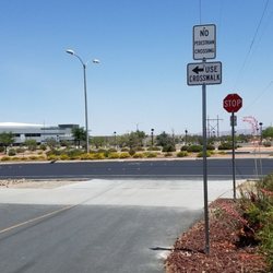
Now that it's cooler we aren't going so early in the morning. Get to sleep in for a change. They've done a lot of work, trimming trees & blowing leaves along the asphalt trail. Now they're cutting back the debris & removing some of the brush & trees down in the wash. Hopefully, all the work isn't affecting the wildlife too badly. We still see rabbits & road runners as we walk along. Use caution crossing Valle Verde even within the crosswalk, using the flashing light. Some drivers just don't slow down or stop. Must be in a big hurry.

I vacationed in Las Vegas and ran the Upper and Lower Las Vegas Wash Trails and the Pittman Wash Trail. By far the Pittman Wash Trail was my favorite. I started at the Arroyo Grande Sports Complex and ran to Pecos Legacy Park and back (~6 miles total). I clocked 6.4 but I got lost crossing N. Green Valley Pkwy, because I started running down E. Windmill Pkwy before I realized I had missed getting back on the trail. Overall 210' of elevation gain on the way there and downhill on the way back. Beautiful scenery with a handful of other runners and walkers in the late morning. Very clean. I would highly recommend this trail over the other two.

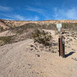
Pitman Wash Trail Description The Pitman Wash Trail follows what is usually a dry wash through residential neighborhoods in Henderson, a southern suburb of Las Vegas, from Pebble Road north to the Arroyo Grande Sports Complex. The trail is paved and the wash corridor is fairly narrow. The trail features nice landscaping, benches and picnic tables, as well as water fountains and clean restrooms at Pecos Legacy Park. You will also find hiking trails, running paths and mountain bike trails down in Pitman Wash between N. Green Valley Parkway and N. Valle Verde Drive. Parking and Trail Access Parking is available at Pecos Legacy Park (150 Pecos Road), Silver Springs Park (1950 Silver Springs Parkway) and Arroyo Grande Sports Complex (298 Arroyo Grande Boulevard). www.traillink.com
")
Decided to bike this trail as part of the Discover our Trails Scavenger Hunt the City of Henderson is hosting this May. If it weren't for this promotion, I would have never discovered how much fun it is to bike this trail! It is a great intermediate challenge (perhaps because I am a little out of shape right now! lol) and most of the views are quite pleasing. I will be back here often to bike or hike. Absolutely enjoyed it and had a lot of fun! Everything appears to be very well maintained and clean. I highly recommend bike and hike enthusiasts to give it a shot, at least once. It's even a great leisurely stroll! Moving back to Green Valley from Summerlin, it's little unknown gems like this that make the transition quite pleasing! :)

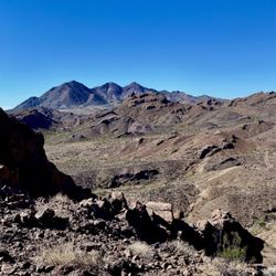
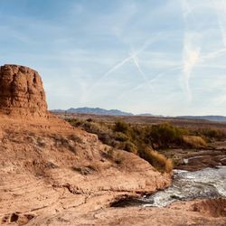
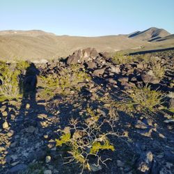
Pittman Wash is a 4 mile multi-use (walking, running, biking and hiking in some parts) greenway running through the newer parts of Henderson (from Pebble Road (near Eastern Ave) to Arroyo Grande Blvd). The wash was originally a natural channel for flood water to push its way west to east across Henderson and the city took advantage of the natural feature to 1) ensure protection from flooding and 2) provide a recreation area for residents away from traffic. On most weekends, you'll find the paved path filled with runners and bikers and families getting a little exercise. In one special portion of the wash (between Green Valley Pkwy and Valle Verde Dr), the city left the wash undisturbed in its natural condition. Nature trails run along the floor of this portion of the wash, winding along through Mojave desert brush and trees. This undisturbed portion is one of the few spaces where city planners in the Vegas valley chose to leave a natural feature among the planned roads and subdivisions. And it's wonderful. For a map of the undisturbed natural portion of Pittman wash, check Project Green's website: https://sites.google.com/site/projectgreenhendersonnv/Home

This trail has received a bit of a well-needed make-over that I really like. The lights all work and are now brighter, the trail has been re-paved and there are these cool artsy-type trail markers now with the name of the trail. I don't go often, especially right now because spring out here gives me a headache, but I really enjoy the trail. My dogs do, too! The new pavement is much nicer on their paws. Great because it's next to my house and you see the occasional exercise enthusiast, but whenever I go it's never too busy.

A nice oasis in this busy city. Has a paved trail to ride you bike or walk or blade or whatever you fancy. We took our dogs down into the wash to explore. We saw plenty of plants and flowers. Birds were chirping and there were squirrels and rabbits crossing our path. A bit noisy near the edges, but when we walked down in the middle of the wash, at times it was total peace and quiet. We parked at the Pecos Park on Pecos/Windmill and the trail was easily accessible from there.

This is a nice paved trail that winds through the residences and a wash. The motion sensor lights get brighten up as you walk/run/bike past them. There's multiple concrete benches whenever you want to take a break from your trail activity. The trees are trimmed as to not get in the way of those who use the trail. There are auxiliary trails that go down into the wash area if you feel like exploring for a little bit. The local residences are usually out in full force when the weather is nice. Sometimes the trails can feel a little too narrow for the traffic on crowded days but not to the point where you have to stop or slow down. Just be aware of trail ahead and all is well. I've been running and biking on this trail for years now and it's a nice way to knock out some easy miles during a long training run. No matter how you travel on the Pittman Wash Trail, you're in for a pretty good time. Enjoy! read more


A straight, flat, asphalt paved trail running the washout. It runs through residential areas and connecting parks. Looks like a real fun bike and skate road. Was a quiet walk overall, but I also liked that you were in civilization. Not too much worries for snakes, dirt or ankle injuries. read more

This is a beautiful trail running through Henderson and providing lots of signage with information even about the fauna and flora around. You can join walking groups to explore this trail if you don't want to do it alone. read more


Now that it's cooler we aren't going so early in the morning. Get to sleep in for a change. They've done a lot of work, trimming trees & blowing leaves along the asphalt trail. Now they're cutting back the debris & removing some of the brush & trees down in the wash. Hopefully, all the work isn't affecting the wildlife too badly. We still see rabbits & road runners as we walk along. Use caution crossing Valle Verde even within the crosswalk, using the flashing light. Some drivers just don't slow down or stop. Must be in a big hurry. read more

3 years ago
I vacationed in Las Vegas and ran the Upper and Lower Las Vegas Wash Trails and the Pittman Wash Trail. By far the Pittman Wash Trail was my favorite. I started at the Arroyo Grande Sports Complex and ran to Pecos Legacy Park and back (~6 miles total). I clocked 6.4 but I got lost crossing N. Green Valley Pkwy, because I started running down E. Windmill Pkwy before I realized I had missed getting back on the trail. Overall 210' of elevation gain on the way there and downhill on the way back. Beautiful scenery with a handful of other runners and walkers in the late morning. Very clean. I would highly recommend this trail over the other two. read more

9 years ago
Pitman Wash Trail Description The Pitman Wash Trail follows what is usually a dry wash through residential neighborhoods in Henderson, a southern suburb of Las Vegas, from Pebble Road north to the Arroyo Grande Sports Complex. The trail is paved and the wash corridor is fairly narrow. The trail features nice landscaping, benches and picnic tables, as well as water fountains and clean restrooms at Pecos Legacy Park. You will also find hiking trails, running paths and mountain bike trails down in Pitman Wash between N. Green Valley Parkway and N. Valle Verde Drive. Parking and Trail Access Parking is available at Pecos Legacy Park (150 Pecos Road), Silver Springs Park (1950 Silver Springs Parkway) and Arroyo Grande Sports Complex (298 Arroyo Grande Boulevard). www.traillink.com read more


3 years ago
Decided to bike this trail as part of the Discover our Trails Scavenger Hunt the City of Henderson is hosting this May. If it weren't for this promotion, I would have never discovered how much fun it is to bike this trail! It is a great intermediate challenge (perhaps because I am a little out of shape right now! lol) and most of the views are quite pleasing. I will be back here often to bike or hike. Absolutely enjoyed it and had a lot of fun! Everything appears to be very well maintained and clean. I highly recommend bike and hike enthusiasts to give it a shot, at least once. It's even a great leisurely stroll! Moving back to Green Valley from Summerlin, it's little unknown gems like this that make the transition quite pleasing! :) read more
 - Hiking Near Me - Henderson, Nevada")
Pittman Wash is a 4 mile multi-use (walking, running, biking and hiking in some parts) greenway running through the newer parts of Henderson (from Pebble Road (near Eastern Ave) to Arroyo Grande Blvd). The wash was originally a natural channel for flood water to push its way west to east across Henderson and the city took advantage of the natural feature to 1) ensure protection from flooding and 2) provide a recreation area for residents away from traffic. On most weekends, you'll find the paved path filled with runners and bikers and families getting a little exercise. In one special portion of the wash (between Green Valley Pkwy and Valle Verde Dr), the city left the wash undisturbed in its natural condition. Nature trails run along the floor of this portion of the wash, winding along through Mojave desert brush and trees. This undisturbed portion is one of the few spaces where city planners in the Vegas valley chose to leave a natural feature among the planned roads and subdivisions. And it's wonderful. For a map of the undisturbed natural portion of Pittman wash, check Project Green's website: https://sites.google.com/site/projectgreenhendersonnv/Home read more


12 years ago
This trail has received a bit of a well-needed make-over that I really like. The lights all work and are now brighter, the trail has been re-paved and there are these cool artsy-type trail markers now with the name of the trail. I don't go often, especially right now because spring out here gives me a headache, but I really enjoy the trail. My dogs do, too! The new pavement is much nicer on their paws. Great because it's next to my house and you see the occasional exercise enthusiast, but whenever I go it's never too busy. read more

A nice oasis in this busy city. Has a paved trail to ride you bike or walk or blade or whatever you fancy. We took our dogs down into the wash to explore. We saw plenty of plants and flowers. Birds were chirping and there were squirrels and rabbits crossing our path. A bit noisy near the edges, but when we walked down in the middle of the wash, at times it was total peace and quiet. We parked at the Pecos Park on Pecos/Windmill and the trail was easily accessible from there. read more


A place to get some peace and quiet without leaving the city. Pittman wash offers solitude and an easy and for the most part well lit path to guide you along. This place is a great place to burn some blubber while exercising or just when you need to get some air and get out of the house. The folks on the trail are usually nice and considerate. You can either walk on the sidewalk above the wash or the dirt paths located in the wash. I usually frequent here during summer nights to get my nightly walk in. You can see some wildlife here if you are patient, such as rabbits tons of em, lizards, quail and such. read more


13 years ago
10 years ago
7 years ago
12 years ago
7 years ago
10 years ago
A GEM of a trail! A coworker recommended this trail and I decided to try it out on a beautiful Sunday. Started at Pebble and Eastern and went all the way to the park at Arroyo Grande in Henderson. Saw a lot of people walking and biking on the trail, as lots of birds chirping and flying about. Lots of places to stop and take a rest as well! A great workout that I will experience again soon I'm sure. read more

11 years ago
I love taking my dog for walks along this trail!! Also really nice for an evening/night stroll :-) read more

12 years ago
11 years ago
I love this trail. There's so much to see, especially when you get into the wash itself. It's so nice to be able to escape into nature while still in the city. read more


11 years ago
Been running, walking, biking these trails for 8 years! Love the friendly people and watching the bunnies late in evenings read more

8 years ago
So lucky to have this awesome trail in my back yard. Great for running, biking or walking the dog. read more

9 years ago
11 years ago
10 years ago
Today was the 1st time I have walked the trail and I just can't believe this has been in my "backyard" for all these years I've lived in Henderson. I was in awe of all the wildlife here in the desert. There was even a small stream of water running. The only downside was a couple of tractors doing some sort of work and part of the trail I was on was grated away from said tractors. But I'm sure there's a legitimate reason for it. I will return for sure and much cheaper more often especial at this time of year before it gets too hot. read more


11 years ago
10 years ago
10 years ago
11 years ago
8 years ago
12 years ago
Page 1 of 2
More info about Pittman Wash Trail
N. Valle Verde Dr & Windmill Pkwy
Henderson, NV 89074
Directions
Hours
Outdoor Amenities
Ask the Community - Pittman Wash Trail
Review Highlights - Pittman Wash Trail


Why does Yelp recommend reviews?
1 review that is not currently recommended
The reviews below are not factored into the business's overall star rating.
13 years ago
Pittman Wash Trail - hiking - Updated May 2026
Best of Henderson
People found Pittman Wash Trail by searching for…
Walking Trails in Henderson, NV
Places to Take Pictures in Henderson, NV
Hiking Trails With Waterfalls in Henderson, NV
Beautiful Views in Henderson, NV
Running Trails in Henderson, NV
Natural Hot Springs in Henderson, NV
Running Routes in Henderson, NV
Dog Friendly Hiking Trails in Henderson, NV
Jogging at Night in Henderson, NV
Jogging Trails in Henderson, NV
Mountain Bike Trails in Henderson, NV
Trending Searches in Henderson, NV
Boat Rental near Pittman Wash Trail
Botanical Gardens near Pittman Wash Trail
Bounce House Rentals near Pittman Wash Trail
Campgrounds near Pittman Wash Trail
Cheap Plants near Pittman Wash Trail
Cliff Jumping near Pittman Wash Trail
Floral Designers near Pittman Wash Trail
Flower Fields near Pittman Wash Trail
Flower Shop near Pittman Wash Trail
Garage Sales near Pittman Wash Trail
Garden Center near Pittman Wash Trail
Lakes & Ponds near Pittman Wash Trail
Nurseries & Gardening near Pittman Wash Trail
Outdoor Activities near Pittman Wash Trail
Outdoor Furniture Stores near Pittman Wash Trail
Party Equipment Rentals near Pittman Wash Trail
Pedicure near Pittman Wash Trail
Photo Spots near Pittman Wash Trail
Picnic Areas near Pittman Wash Trail
Places To Take Pictures near Pittman Wash Trail
Rock Quarry near Pittman Wash Trail
Running Trails near Pittman Wash Trail
Rv Rental near Pittman Wash Trail
Scenic Drive near Pittman Wash Trail
Sunrise View near Pittman Wash Trail
Swimming Holes near Pittman Wash Trail
Table And Chair Rentals near Pittman Wash Trail
Browse Articles
Browse Nearby
BEST of Henderson, Nevada Coffee near Pittman Wash Trail
BEST of Henderson, Nevada Things to Do near Pittman Wash Trail
BEST of Henderson, Nevada Restaurants near Pittman Wash Trail
BEST of Henderson, Nevada Breakfast near Pittman Wash Trail
BEST of Henderson, Nevada Parks near Pittman Wash Trail
BEST of Henderson, Nevada Walking Trails near Pittman Wash Trail
BEST of Henderson, Nevada Hotels near Pittman Wash Trail
BEST of Henderson, Nevada Campgrounds near Pittman Wash Trail
Browse Brands
Related Searches in Henderson, NV
Affordable Kayak Rental Services in Henderson, Nevada
Best Fishing Locations and Guides in Henderson, Nevada
Best Nature Trails for Hiking in Henderson, Nevada
Best Places for Horseback Riding in Henderson, Nevada
Check Out Off Road Trails in Henderson, Nevada
Discover Dog Friendly Trails to Explore in Henderson, Nevada
Discover Scenic Mountain Bike Trails Near Henderson, Nevada
Discover Scenic Walking Paths in Henderson, Nevada
Discover Top Nature Parks to Visit in Henderson, Nevada
Discover Walking Parks in Henderson, Nevada Near You
Discover a Hiking Trail in Henderson, Nevada
Discover the Best Night Hike Trails in Henderson, Nevada
Discover the Best Running Track in Henderson, Nevada
Dog-Friendly Hikes With Dogs in Henderson, Nevada
Enjoy Camping Adventures Around Henderson, Nevada
Enjoy Exciting Mountain Biking Adventures in Henderson, Nevada
Enjoy Kayaking Adventures in Henderson, Nevada
Enjoy Tent Camping Spots Around Henderson, Nevada
Enjoy a Scenic Walk in Henderson, Nevada
Enjoy the Best Walking Trails in Henderson, Nevada
Exciting Cliff Jumping Spots in Henderson, Nevada
Explore Beautiful Parks and Green Spaces in Henderson, Nevada
Explore Easy Hikes Perfect for All in Henderson, Nevada
Explore Fun Activities to Do in Henderson, Nevada
Explore Popular Campgrounds Near Henderson, Nevada
Explore the Best Beach Spots in Henderson, Nevada
Explore the Best Boating Spots in Henderson, Nevada
Explore the Best Swimming Holes Around Henderson, Nevada
Explore the Best Trail Options in Henderson, Nevada
Family Friendly Hiking With Kids in Henderson, Nevada
Find Beautiful Views in Henderson, Nevada
Find Popular Ziplining Spots Around Henderson, Nevada
Find the Best Parks for Picnics in Henderson, Nevada
Find the Best Scenic View Locations in Henderson, Nevada
Hiking Trails With Waterfalls in Henderson, Nevada
Off Leash Dog Hiking Trails in Henderson, Nevada
Plan a Scenic Drive Route Near Henderson, Nevada
Popular Fishing Spots to Explore in Henderson, Nevada
Popular Outdoor Activities to Try in Henderson, Nevada
Popular Picnic Spots to Visit in Henderson, Nevada
Safe River Swimming Areas in Henderson, Nevada
Safe and Fun Parks for Kids in Henderson, Nevada
Top Climbing Spots and Gyms in Henderson, Nevada
Top Paddleboarding Activities in Henderson, Nevada
Top Running Trails to Explore in Henderson, Nevada
Top Swimming Lakes to Enjoy in Henderson, Nevada
Top Swimming Spots and Pools in Henderson, Nevada
Top Things to Do With Kids in Henderson, Nevada
People who viewed Pittman Wash Trail also viewed
Whitney Mesa Recreation Area
57 reviews
McCullough Hills Trail
13 reviews
Black Mountain Trail
50 reviews
Lake Mead Parkway Trail
2 reviews
Petroglyph Trail
4 reviews
Park Peak Trail 403
4 reviews
I-215 East Beltway Trail
2 reviews
Southeast
Wetlands Trail Connector
6 reviews
Cornerstone Park
154 reviews
Lake Las Vegas Overlook
2 reviews