Milagra Ridge Photos


You might also consider
More like Milagra Ridge
Recommended Reviews - Milagra Ridge
Start your review...


13 years ago


9 years ago
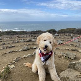
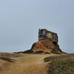
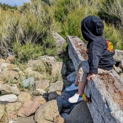
Agree with the others - this is a wonderful, not-too-long, not-too-short hike with a wonderful view, beautifully-maintained trails, amazing variety of plant and animal life, and the gun batteries are an unexpected bonus! It's a quiet hike, not too many people on the Tues morning we were there. There is limited parking (and it's not very clear it's actually parking, but it is, lol). Do take the Summit trail to the top because the view is amazing, especially as the fog is rolling in/out. The WWII gun battery placements are a cool bonus. Saw a few rabbits, some beautiful flowers, and some really cool rocks. If I lived there, I'd be hiking that trail every day! read more


16 years ago
15 years ago
16 years ago
8 years ago
18 years ago
17 years ago
11 years ago
16 years ago
11 years ago
12 years ago
18 years ago
13 years ago
10 years ago
13 years ago
13 years ago
12 years ago
18 years ago
12 years ago
8 years ago
18 years ago
12 years ago
15 years ago
Page 2 of 2
More info about Milagra Ridge
641 Sharp Park Rd
Pacifica, CA 94044
Directions
(415) 561-4700
Call Now
Hours
Indoor Amenities
Outdoor Amenities
Ask the Community - Milagra Ridge
Review Highlights - Milagra Ridge
You might also consider


Why does Yelp recommend reviews?
1 review that is not currently recommended
The reviews below are not factored into the business's overall star rating.
8 years ago
Milagra Ridge - parks - Updated May 2026
Best of Pacifica
People found Milagra Ridge by searching for…
Walking Trails in Pacifica, CA
Beautiful Views in Pacifica, CA
Off Road Trails in Pacifica, CA
Urban Exploration in Pacifica, CA
Dog Friendly Hiking Trails in Pacifica, CA
Cruising Spots in Pacifica, CA
Dirt Bike Riding in Pacifica, CA
Parks for Kids in Pacifica, CA
Trending Searches in Pacifica, CA
Baseball Fields near Milagra Ridge
Botanical Gardens near Milagra Ridge
Bounce House Rentals near Milagra Ridge
Campgrounds near Milagra Ridge
Cheap Plants near Milagra Ridge
Cherry Picking near Milagra Ridge
Cliff Jumping near Milagra Ridge
Dog Friendly Things To Do near Milagra Ridge
Flower Fields near Milagra Ridge
Flower Shop near Milagra Ridge
Garage Sales near Milagra Ridge
Garden Center near Milagra Ridge
Lakes & Ponds near Milagra Ridge
Nurseries & Gardening near Milagra Ridge
Off Leash Dog Parks near Milagra Ridge
Outdoor Activities near Milagra Ridge
Outdoor Basketball Courts near Milagra Ridge
Outdoor Furniture Stores near Milagra Ridge
Parks For Parties near Milagra Ridge
Party Equipment Rentals near Milagra Ridge
Photo Spots near Milagra Ridge
Picnic Areas near Milagra Ridge
Places To Take Pictures near Milagra Ridge
Places To Take Pictures For Prom near Milagra Ridge
Public Beaches near Milagra Ridge
Public Running Track near Milagra Ridge
Rock Quarry near Milagra Ridge
Running Trails near Milagra Ridge
Spray Tanning near Milagra Ridge
Sunrise View near Milagra Ridge
Swimming Holes near Milagra Ridge
Table And Chair Rentals near Milagra Ridge
Tennis Courts near Milagra Ridge
Browse Nearby
BEST of Pacifica, California Coffee near Milagra Ridge
BEST of Pacifica, California Restaurants near Milagra Ridge
BEST of Pacifica, California Things to Do near Milagra Ridge
BEST of Pacifica, California Breakfast near Milagra Ridge
BEST of Pacifica, California Playgrounds near Milagra Ridge
BEST of Pacifica, California Picnic Areas near Milagra Ridge
BEST of Pacifica, California Campgrounds near Milagra Ridge
Browse Brands
Related Searches in Pacifica, CA
Affordable Kayak Rental Services in Pacifica, California
Best Fishing Locations and Guides in Pacifica, California
Best Nature Trails for Hiking in Pacifica, California
Best Off Leash Dog Parks in Pacifica, California
Best Parks for Parties and Events in Pacifica, California
Best Places for Horseback Riding in Pacifica, California
Best Water Parks for Kids in Pacifica, California
Best Waterfalls and Swimming Holes in Pacifica, California
Check Out Great Playgrounds in Pacifica, California
Check Out Off Road Trails in Pacifica, California
Discover Baseball Fields Around Pacifica, California
Discover Beautiful Garden Spots in Pacifica, California
Discover Dog Friendly Trails to Explore in Pacifica, California
Discover Fun Toddler Parks in Pacifica, California for Your Little One
Discover Kid Friendly Hiking Trails in Pacifica, California
Discover Lakes & Ponds to Explore in Pacifica, California
Discover Popular Photo Spots in Pacifica, California
Discover Public Beaches to Visit in Pacifica, California
Discover Scenic Hiking Trails in Pacifica, California
Discover Scenic Mountain Bike Trails Near Pacifica, California
Discover Scenic Waterfall Spots in Pacifica, California
Discover Soccer Fields in Pacifica, California Near You
Discover Top State Parks to Visit in Pacifica, California
Discover Walking Parks in Pacifica, California Near You
Discover a Hiking Trail in Pacifica, California
Discover the Best Beaches in Pacifica, California
Discover the Best Kids Park Spots in Pacifica, California
Discover the Best Night Hike Trails in Pacifica, California
Discover the Best Running Track in Pacifica, California
Dog-Friendly Hikes With Dogs in Pacifica, California
Enjoy Camping Adventures Around Pacifica, California
Enjoy Kayaking Adventures in Pacifica, California
Enjoy Tent Camping Spots Around Pacifica, California
Enjoy a Beautiful Waterfall Hike in Pacifica, California
Enjoy the Best Picnic Spots and Ideas in Pacifica, California
Enjoy the Best Walking Path in Pacifica, California
Enjoy the Best Walking Trails in Pacifica, California
Explore Beautiful Botanical Gardens in Pacifica, California
Explore Beautiful Parks and Green Spaces in Pacifica, California
Explore Easy Hikes Perfect for All in Pacifica, California
Explore Family-Friendly Zoos and Wildlife in Pacifica, California
Explore Free Picnic Areas Around Pacifica, California
Explore Fun Activities to Do in Pacifica, California
Explore Parks With Pull Up Bars in Pacifica, California
Explore Popular Campgrounds Near Pacifica, California
Explore Popular Picnic Areas Around Pacifica, California
Explore Popular RV Parks Around Pacifica, California
Explore Popular Recreation Centers Around Pacifica, California