Milagra Ridge Photos


You might also consider
More like Milagra Ridge
Recommended Reviews - Milagra Ridge
Start your review...

Reviews With Photos

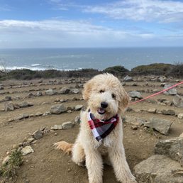
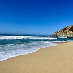
Bear and I needed to escape the Silicon Valley heat on July 4, and we didn't want to deal with all the beach traffic so we made the short drive to Milagra Ridge. While I've driven past the access road many times, this was my first time there. There are several trails to choose from, included a wide paved path for those who prefer / need it. We mixed it up a bit on the way to the summit, and then followed a trail down the other side of the mountain that dumped us out at the high school, and a short walk to the beach from there. Lots of pollinators and some great views.

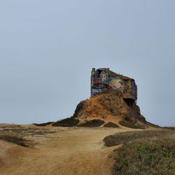
Everyone, me included, gravitates to the beaches and coastal trails in Pacifica, but I've recently started looking toward the hills for sensory fulfillment. I came upon this small patch of open space when I was reading a hiking blog about it. It was a bit hidden off Sharp Patk Road and required a left turn onto residential College Road. The trail starts at the end of the road. I got lucky and found room on the shoulder to park. There's no lot available, so hopefully there will be space for you given there's room for maybe five vehicles at the most. Surrounded by coastal scrub and wildflowers, the main trail was paved and mostly flat until I reached a dirt path with steps that took me to the summit where there were sweeping views of Pacifica below and the ocean toward the horizon. From here, I walked down a long set of steps to an old military bunker covered in graffiti. Instagram moment! Further down the hill was a fenced-off labyrinth, and the scenic trail continued to descend into a series of switchbacks lined with huge rocks and brush foliage. Retracing my steps back toward the summit, I followed the well-tended ridge trail back to my car with winds blowing at full force and plenty of dog walkers trundling the other way. It wasn't a lengthy walk, perhaps three miles at most, but the panoramic views from the ridge top made the journey here worthwhile. RELATED - Up for a hike? Here's a collection of trails I've walked and reviewed: https://bit.ly/2OrC8nU

Super short and fairly easy little hike out to the Milagra Summit. I'd say it's about 1.5 miles roundtrip, but you can shorten or extend this hike as much as you desire. After hanging out at the beach, I decided to do a quick little jaunt up the ridge to catch the sunset. If you're parking from the Sharp Park Road entrance, it's extremely limited. In fact, there isn't even a parking lot. You'll basically be parallel parking on the sides of the streets (Sharp Park Road dead ends into the beginning of the trailhead). I started up the Spur Trail and took it to the Milagra Summit. The trail is mainly a dirt path lined by shrubbery and flowers. It's a nice little trail but nothing extraordinary. I'd say that the best part of this trail are the coastal views. It won't take you too long before you're hit with the oceanside scenery. The sunset views are pretty spectacular here as well. The view from the summit it nice, but you pretty much get the same views that you would from the trailhead. There's also a neat WWII Bunker near the top of the summit. This seems like more of a locals kind of trail. Perfect for walking the dogs or for a quick neighborly stroll. The bugs can be extremely aggressive though. It actually stopped me from fully enjoying my hike. Not sure if this was because it was summer time, but I'd definitely recommend long sleeves shirts and pants. All in all, it was a nice short little trek. However, I wouldn't go out of my my way to come back. There's just too many other amazing hiking spots in this area to make me want to come back here again.

COVID-19 precautions. Beautiful trail. Short and sweet distance that's moderately difficulty. Lightly trafficked. Dog friendly. Parking at Skyline limited to few cars, but more parking at other entrance. See below for more info: COVID-19 precautions: Fellow hikers, walkers, and runners were good about mask wearing, which unfortunately is not the case for most nature places in the Bay. People keep a physical distance and are respectful about passing. The trails are clean. Beautiful trail: As a MILA how could I not love MILAgra Ridge Trail? On a serious note, the Milagra Ridge Trail is beautiful. You have views of the water and lovely nature. The trails consist of dirt surrounded by greenery but you will encounter paved areas, just to a much smaller extent. There are stairs when going from the Skyline entrance to the trail. Overall, a wonderful place to get some exercise! :D Short and sweet distance that's moderately difficulty: The trail is short and sweet, 1.4 miles one way or 2.8 round trip. Depending on where you begin will impact when you encounter the moderate difficulty. If you're like us and park at the Skyline entrance, the trail will be downhill and then all uphill on the return. If you park on the end near the Oceana Pet Hospital, then the hike will be difficult in the begging and all smooth sailing on the return. Lightly trafficked: Another reason we enjoy Milagra Ridge is how it is lightly trafficked. People can truly enjoy hikes, runs, or walks without the crowd. Dog friendly: Milagra Ridge is dog friendly. Many walk, hike or run with their furry friends on leashes. Parking at Skyline limited to few cars, but more parking at other entrance: We arrived at six in the morning and were able to get a parking spot at the Skyline entrance as there was only one other car. However, getting a spot at Skyline can get more challenging, especially later in the day as there are only a few spots. We recommend parking and hiking from the other end as there are more parking spots. You would enter the Oceana Pet Hospital to your GPS. Once you arrive there, you go all the way up Connemara Drive to the end where there is a parking lot for Milagra Ridge Visitors.

Brilliant local secret... Located in Pacifica, Milagra Ridge is smack down in the middle of several neighborhoods. Apparently it has a very rich history going back to the 1700's! The city of Pacifica curently claims ownership to Milagra Ridge...but at one point the Army owned it and there were 6-inch guns mounted at Milagra Ridge!! All part of a project to defend the San Francisco Bay program! Part of the Golden Gate National Recreation Area; the entire open space is an isolated island ecosystem of protected habitat for native plants and animals. I did see several Butterflies and birds of prey when I was there. With several easy trails and a paved road within the entire open space I would say this is an easy spot to go "hiking" felt more like a stroll to me. The view from the top is brilliant! Unfortunately I didn't see the the Ocean due to KARL (SF fog! I have no idea why it's called that...maybe some guy named Karl discovered it?!) lurking around... Looks like I will need to return for a stroll or a nice run and try again! But I can imagine the views on a clear day.

Awesome hike, even in the heavy winter fog. This is probably even more gorgeous on a warmer spring or summer day. We came for New Year's day -- it's our annual tradition to do a hike to kick off the new year. Pros: Dog friendly, and the people on this trail have been very respectful and keep this place pristine. Keep it up and if you're new to hiking here, bag your shit! Great combination of dirt trails, uphill / downhill, cliffside views, and paved roads. The paved roads are good for toddlers or early walkers but be careful of trails that are open on one side to steep hill drops in one area. Panoramic views of the ocean and Pacifica piers!! Absolutely gorgeous even in the fog. There's some benches at the best vista points for your meditation and zoning-out delight :) Decent uphill bun-burner of a hike coming back. Some interesting rock arrangements (similar to Lands End in SF) and old missile sites like at Fort Funston. Cons: Can be a little muddy on dirt trails and near the Sharp Park Rd side parking. Bring rags to wipe muddy paws. Pretty sparse parking. There's like 6 spots worth of parallel parking on a cul de sac on the Sharp Park road side (this was hard for some larger cars to turn out of), and slightly more parking in a normal paved lot on the Connemara side at the end of a neighborhood cul de sac (but it appears to be general public parking that might be shared with guests of residents, with a 2(?) hour time limit).
Milagra Ridge has a bunch of different paved trails- some are an easier climb than others, but most are fairly easy. The trail is dog friendly and my pup loved the walk. There is a restroom if you walk down the cemented trail with a trash can outside where you can throw away your dog poop- but of course not everyone picks up after their dogs- so watch out for that along the trails. Parking is a bit tough- there's probably about 6 spots you can park in right in front of the entrance to the trails. Pretty views on a clear day, but definitely bring a jacket because it gets fairly windy. I would visit again and try a different trail :)

If you're looking for an easy, peaceful hike, Milagra Ridge is the right place for you. It's not popular like Mori Point, so you can easily avoid people, which covid has taught us is the new necessity. There's a slight incline, so when you reach the top, you get beautiful views of Pacifica and the ocean (if the fog isn't too thick). There are only about 6 parking spots by the entrance, but you can park in the surrounding neighborhood. Overall, a very nice get away.

PSA: wear sunscreen! It's not super sunny (usually foggy given it's Pacifica) but just thought I'd throw this out there as a Public Skincare Announcement * Parking in the trail head by Skyline college (aka the Sharp Park road entrance) is a hit or miss-- there may or may not be street parking (the rest are private parking only). However, if you park up the hill past the Oceana Pet Hospital, you will find a smalll parking lot, or street parking in the residential area. * Distance: 1.4mi round trip. Perfect for me ha * History: you'll see small concrete buildings along the route that have a handy little sign pointing to them along the way. Makes you curious about what this trail used to be in years past.. post-trail, looking online, I found that this trail was historically a lookout site for the US army in the 1930s to defend the SF bay, and the National Guard defended the area until it was handed over to Pacifica as a National Recreation area in 1987! So there's something to tell your walking companion * Special: This is the way to the "lone tree"~

Beautiful views of the ocean. You could see Mori Point below if you look closely. Loved coming here! The parking situation was a hassle. We packed in the neighborhood but we had to walk quite a bit to finally get in. If you want, you can just park behind other cars on the left side of the road when you get to the small parking area.

The views are spectacular. The climb is easy. The trails are kept. There's a Cypress on the hill that a gnome lives inside of. Pretty cute The bunkers are as creepy as they are cool. They include history lessons on their markers too which is pretty awesome. There are several stops along the way up (it's only about a mile) if you need/want to stop. Benches and places to sit on the ground, which is nice so you exercise but also feel you can stop if you need/want to. Pacifica offers many trails to hike along the beach front, it was cool to have a different kind of hike here. Where the ocean views are still phenomenal. A lot of off road biking here if you're into that. Dog friendly, but only 1 garbage can in the beginning to throw away Easy, not crowded (but we go on week days). Come enjoy a day or a sunset out.

The main loop is about 1.4 miles and takes around 35 minutes. For more of a hike I'd recommend the trail to Connemara Drive and back, which is around 3 miles. This one has more elevation, so it feels more like a hike but the other feels more like a walk. The walk is nice with vast views of the ocean, hills, some bunkers with graffiti, and planes from nearby SFO. While the views are good it doesn't seem too remote, you are on a ridge with houses, so it feels more like an extended backyard than a wilderness hike. I think it's better for people that live in the area but there are other places in the Peninsula more suited for a hike where you feel like you are away from civilization. I wasn't impressed with the parking here. There are only around 5-7 spots. I've only been here during the weekdays so I'd imagine the weekend getting full. read more


2 years ago
Bear and I needed to escape the Silicon Valley heat on July 4, and we didn't want to deal with all the beach traffic so we made the short drive to Milagra Ridge. While I've driven past the access road many times, this was my first time there. There are several trails to choose from, included a wide paved path for those who prefer / need it. We mixed it up a bit on the way to the summit, and then followed a trail down the other side of the mountain that dumped us out at the high school, and a short walk to the beach from there. Lots of pollinators and some great views. read more


10 months ago
Everyone, me included, gravitates to the beaches and coastal trails in Pacifica, but I've recently started looking toward the hills for sensory fulfillment. I came upon this small patch of open space when I was reading a hiking blog about it. It was a bit hidden off Sharp Patk Road and required a left turn onto residential College Road. The trail starts at the end of the road. I got lucky and found room on the shoulder to park. There's no lot available, so hopefully there will be space for you given there's room for maybe five vehicles at the most. Surrounded by coastal scrub and wildflowers, the main trail was paved and mostly flat until I reached a dirt path with steps that took me to the summit where there were sweeping views of Pacifica below and the ocean toward the horizon. From here, I walked down a long set of steps to an old military bunker covered in graffiti. Instagram moment! Further down the hill was a fenced-off labyrinth, and the scenic trail continued to descend into a series of switchbacks lined with huge rocks and brush foliage. Retracing my steps back toward the summit, I followed the well-tended ridge trail back to my car with winds blowing at full force and plenty of dog walkers trundling the other way. It wasn't a lengthy walk, perhaps three miles at most, but the panoramic views from the ridge top made the journey here worthwhile. RELATED - Up for a hike? Here's a collection of trails I've walked and reviewed: https://bit.ly/2OrC8nU read more


Super short and fairly easy little hike out to the Milagra Summit. I'd say it's about 1.5 miles roundtrip, but you can shorten or extend this hike as much as you desire. After hanging out at the beach, I decided to do a quick little jaunt up the ridge to catch the sunset. If you're parking from the Sharp Park Road entrance, it's extremely limited. In fact, there isn't even a parking lot. You'll basically be parallel parking on the sides of the streets (Sharp Park Road dead ends into the beginning of the trailhead). I started up the Spur Trail and took it to the Milagra Summit. The trail is mainly a dirt path lined by shrubbery and flowers. It's a nice little trail but nothing extraordinary. I'd say that the best part of this trail are the coastal views. It won't take you too long before you're hit with the oceanside scenery. The sunset views are pretty spectacular here as well. The view from the summit it nice, but you pretty much get the same views that you would from the trailhead. There's also a neat WWII Bunker near the top of the summit. This seems like more of a locals kind of trail. Perfect for walking the dogs or for a quick neighborly stroll. The bugs can be extremely aggressive though. It actually stopped me from fully enjoying my hike. Not sure if this was because it was summer time, but I'd definitely recommend long sleeves shirts and pants. All in all, it was a nice short little trek. However, I wouldn't go out of my my way to come back. There's just too many other amazing hiking spots in this area to make me want to come back here again. read more


COVID-19 precautions. Beautiful trail. Short and sweet distance that's moderately difficulty. Lightly trafficked. Dog friendly. Parking at Skyline limited to few cars, but more parking at other entrance. See below for more info: COVID-19 precautions: Fellow hikers, walkers, and runners were good about mask wearing, which unfortunately is not the case for most nature places in the Bay. People keep a physical distance and are respectful about passing. The trails are clean. Beautiful trail: As a MILA how could I not love MILAgra Ridge Trail? On a serious note, the Milagra Ridge Trail is beautiful. You have views of the water and lovely nature. The trails consist of dirt surrounded by greenery but you will encounter paved areas, just to a much smaller extent. There are stairs when going from the Skyline entrance to the trail. Overall, a wonderful place to get some exercise! :D Short and sweet distance that's moderately difficulty: The trail is short and sweet, 1.4 miles one way or 2.8 round trip. Depending on where you begin will impact when you encounter the moderate difficulty. If you're like us and park at the Skyline entrance, the trail will be downhill and then all uphill on the return. If you park on the end near the Oceana Pet Hospital, then the hike will be difficult in the begging and all smooth sailing on the return. Lightly trafficked: Another reason we enjoy Milagra Ridge is how it is lightly trafficked. People can truly enjoy hikes, runs, or walks without the crowd. Dog friendly: Milagra Ridge is dog friendly. Many walk, hike or run with their furry friends on leashes. Parking at Skyline limited to few cars, but more parking at other entrance: We arrived at six in the morning and were able to get a parking spot at the Skyline entrance as there was only one other car. However, getting a spot at Skyline can get more challenging, especially later in the day as there are only a few spots. We recommend parking and hiking from the other end as there are more parking spots. You would enter the Oceana Pet Hospital to your GPS. Once you arrive there, you go all the way up Connemara Drive to the end where there is a parking lot for Milagra Ridge Visitors. read more


6 years ago
Brilliant local secret... Located in Pacifica, Milagra Ridge is smack down in the middle of several neighborhoods. Apparently it has a very rich history going back to the 1700's! The city of Pacifica curently claims ownership to Milagra Ridge...but at one point the Army owned it and there were 6-inch guns mounted at Milagra Ridge!! All part of a project to defend the San Francisco Bay program! Part of the Golden Gate National Recreation Area; the entire open space is an isolated island ecosystem of protected habitat for native plants and animals. I did see several Butterflies and birds of prey when I was there. With several easy trails and a paved road within the entire open space I would say this is an easy spot to go "hiking" felt more like a stroll to me. The view from the top is brilliant! Unfortunately I didn't see the the Ocean due to KARL (SF fog! I have no idea why it's called that...maybe some guy named Karl discovered it?!) lurking around... Looks like I will need to return for a stroll or a nice run and try again! But I can imagine the views on a clear day. read more


Awesome hike, even in the heavy winter fog. This is probably even more gorgeous on a warmer spring or summer day. We came for New Year's day -- it's our annual tradition to do a hike to kick off the new year. Pros: Dog friendly, and the people on this trail have been very respectful and keep this place pristine. Keep it up and if you're new to hiking here, bag your shit! Great combination of dirt trails, uphill / downhill, cliffside views, and paved roads. The paved roads are good for toddlers or early walkers but be careful of trails that are open on one side to steep hill drops in one area. Panoramic views of the ocean and Pacifica piers!! Absolutely gorgeous even in the fog. There's some benches at the best vista points for your meditation and zoning-out delight :) Decent uphill bun-burner of a hike coming back. Some interesting rock arrangements (similar to Lands End in SF) and old missile sites like at Fort Funston. Cons: Can be a little muddy on dirt trails and near the Sharp Park Rd side parking. Bring rags to wipe muddy paws. Pretty sparse parking. There's like 6 spots worth of parallel parking on a cul de sac on the Sharp Park road side (this was hard for some larger cars to turn out of), and slightly more parking in a normal paved lot on the Connemara side at the end of a neighborhood cul de sac (but it appears to be general public parking that might be shared with guests of residents, with a 2(?) hour time limit). read more


6 years ago
Milagra Ridge has a bunch of different paved trails- some are an easier climb than others, but most are fairly easy. The trail is dog friendly and my pup loved the walk. There is a restroom if you walk down the cemented trail with a trash can outside where you can throw away your dog poop- but of course not everyone picks up after their dogs- so watch out for that along the trails. Parking is a bit tough- there's probably about 6 spots you can park in right in front of the entrance to the trails. Pretty views on a clear day, but definitely bring a jacket because it gets fairly windy. I would visit again and try a different trail :) read more

If you're looking for an easy, peaceful hike, Milagra Ridge is the right place for you. It's not popular like Mori Point, so you can easily avoid people, which covid has taught us is the new necessity. There's a slight incline, so when you reach the top, you get beautiful views of Pacifica and the ocean (if the fog isn't too thick). There are only about 6 parking spots by the entrance, but you can park in the surrounding neighborhood. Overall, a very nice get away. read more


6 years ago
PSA: wear sunscreen! It's not super sunny (usually foggy given it's Pacifica) but just thought I'd throw this out there as a Public Skincare Announcement * Parking in the trail head by Skyline college (aka the Sharp Park road entrance) is a hit or miss-- there may or may not be street parking (the rest are private parking only). However, if you park up the hill past the Oceana Pet Hospital, you will find a smalll parking lot, or street parking in the residential area. * Distance: 1.4mi round trip. Perfect for me ha * History: you'll see small concrete buildings along the route that have a handy little sign pointing to them along the way. Makes you curious about what this trail used to be in years past.. post-trail, looking online, I found that this trail was historically a lookout site for the US army in the 1930s to defend the SF bay, and the National Guard defended the area until it was handed over to Pacifica as a National Recreation area in 1987! So there's something to tell your walking companion * Special: This is the way to the "lone tree"~ read more


5 years ago
Beautiful views of the ocean. You could see Mori Point below if you look closely. Loved coming here! The parking situation was a hassle. We packed in the neighborhood but we had to walk quite a bit to finally get in. If you want, you can just park behind other cars on the left side of the road when you get to the small parking area. read more


6 years ago
The views are spectacular. The climb is easy. The trails are kept. There's a Cypress on the hill that a gnome lives inside of. Pretty cute The bunkers are as creepy as they are cool. They include history lessons on their markers too which is pretty awesome. There are several stops along the way up (it's only about a mile) if you need/want to stop. Benches and places to sit on the ground, which is nice so you exercise but also feel you can stop if you need/want to. Pacifica offers many trails to hike along the beach front, it was cool to have a different kind of hike here. Where the ocean views are still phenomenal. A lot of off road biking here if you're into that. Dog friendly, but only 1 garbage can in the beginning to throw away Easy, not crowded (but we go on week days). Come enjoy a day or a sunset out. read more


 - Parks Near Me - Pacifica, California")


6 years ago
Easy and very scenic hike! On a cloudless, hot and breezy day, this park is a fantastic dog walking trail! However, I can imagine that on a regular Pacifica day it would be very windy and foggy in this area Check out my IGTV @assetimages to see the views read more

This is a very beautiful park. You can see pretty beach in Pacifica, Mt.Tam, and even Twin Peaks in the city. This park is not super popular, so you can enjoy a quiet hike. Also, some Nike missile site and WWII Gun Battery site are interesting. There are only 3 miles total, but nice mini hike! read more


6 years ago
Great sunset hike. It's A shorter hike with beautiful views of Pacifica. Lots of nature and wild animals. your pups too are welcome but I recommend them being lashed especially during sunset when more animals start to come out ! read more

9 years ago
This is a very beautiful place. Spectacular views (somehow reminds me of Hawaii), expansive view of the coast, and a few summits and overlooks. The trails are well-maintained, and the paved roads are nice and wide. Not very strenuous, not much shade, but a good distance for a walk/short hike on the weekend. This place also isn't very crowded. These factors alone would've made this place 5 stars, except that it is incredibly windy here, even on a normal, sunny day. It is SO WINDY here that I'd venture to say it is unpleasant enough to never come back here. If you've never been here, I'd say, wear warm clothes and hike/walk here at least once, because the views are so great here. It is so ridiculously windy here that you can't wear a hat, not even a baseball hat; you cannot carry on a conversation because the gusting wind makes it impossible to hear; your hair (if you have long hair) will get incredibly knotted and will be blown all over your face so you can't really enjoy the views; your ears get freezing cold; it's hard to stand still and take a picture; and at some points you feel like you're going to get blown over. The wind is also relentless and unforgiving, at all points during the trails. I don't know what is wrong with the weather here, but this wind was awful. read more


9 years ago
Milagra Ridge is the perfect complement to a walk on Mori Point, but it's even more important to have clear weather up here as the view of the Pacifica coastline is kind of the raison d'etre (although I hear the spring wildflowers are nice too). It's also a very convenient stop if you're already going to Sweeney Ridge. Like Mori, Milagra is a recent addition to the GGNRA (it was formerly a Nike missile site) and you can tell it's meticulously maintained, with roped-in trails and lots of native plant restoration. It's really just a small piece of treeless ridgetop, with the longest possible walk only a mile and a half, but it's quite serene and would be a fantastic sunset-watching spot. For more details on hiking here, see http://www.bahiker.com/southbayhikes/milagra.html. Note that the entrance to the park is on the north side of the intersection of Sharp Park Rd and College Dr...I'm having trouble getting that to show up on the map. read more


7 years ago
Great easy hike in Pacifica. Parked off the entrance next to Skyline college. Did an easy mile hike within my lunch hour. Lots of dog poop and very windy so be mindful of those two things. Wear a wind breaker and sunglasses because the wind gets really strong. read more

This is a great spot for a pre-dinner / sunset hike. It is adequately short with coastal vistas all around. When you get to the summit, you can see and dance around the remains of the old World War II Battery and the Nike Missile Launcher area. While native Californians may not color this place heart-stoppingly beautiful--the ocean view, the sparkling sunset, and the cuddly bunnies are more than enough to draw me back for another visit. read more

8 years ago


6 years ago
8 years ago
16 years ago
This evening, my 2.5 yr old R and I left for a walk (which turned into a hike) at Milagra Ridge County Park. It was super foggy and a bit windy, but it wasn't that cold. We drove to the Ridge mainly due to time . . . eventually I would like to be able to walk to it. I live quite close, but this lady is getting INTO shape. Not there yet. I pulled into a parking spot and R was full of chatter "Walking Mama, go walking!" She was so excited. We walked past the gate and she was full of glee at not having to hold my hand :) We reached an area where the path forks, we went left to go along the dirt path to the edge. I was a little worried when we did so because of all the holes which I thought were snake holes? Still unsure . . . We kept going along the path and actually walked past the fog bed and could see Pacifica from the edge. We stopped, looked, took a picture and kept on walking. As we went back around now back on the path, R had slowed down quite a bit. I was worried she would make it! The Park Ranger drove by and said Hi, that seemed to pep her back up! She started running more and even asked me to. As we rounded the mountain back toward the car, she asked "Uppy Mama, please" so I put her on my back and carried her. I figured I forced the long walk on her - she had no idea we had to walk back! Once she saw the car, we were both so excited! "We did it" she shouted and I got teary - we had done it. Great location for moderate exercise. I mean, if my 2.5 yr old can do it . . . we all can :D read more
 - Parks Near Me - Pacifica, California")

8 years ago
This was easy to find great to walk an easy to walk beautiful views . I must have picked a great day not to much wind but thanks to the other yelps I can see how that could change quickly! read more


Easy trail, ocean views, quiet, and cute small wild life PERFECT place for a quick hike or jog. I saw the large sign when driving down Sharp Park and decided to see what was here. Wonderful place for a Sunday late afternoon hike, and surprisingly not crowded (when the beaches and other trails are were packed on a warm weekend). + Peaceful :) (not crowded) + Cross paths with a few bunnies + Listen to many song birds in the bushes while you hike + Panoramic views of the Pacific and within minutes from the trail head, you'll see the great views (instant gratification!) + touch of history (Nike Missile Launch Area Signage: Informational and in good condition According to the signs: - poison oak, ticks, possible coyotes (though it includes tips on what to do if you encounter any) - no bikes + dogs w/ leashes (Also cool that the high school below the ridge, Oceana HS, has students who help with the conservation efforts here.) TIP: When entering or leaving there's a dip @ the entrance for Sharp Park & College, GO SLOWLY or you WILL scrape the bottom of your front bumper. read more


13 years ago
6 years ago
Page 1 of 2
More info about Milagra Ridge
641 Sharp Park Rd
Pacifica, CA 94044
Directions
(415) 561-4700
Call Now
Hours
Indoor Amenities
Outdoor Amenities
Ask the Community - Milagra Ridge
Review Highlights - Milagra Ridge
You might also consider


Why does Yelp recommend reviews?
1 review that is not currently recommended
The reviews below are not factored into the business's overall star rating.
8 years ago
Milagra Ridge - parks - Updated June 2026
Best of Pacifica
People found Milagra Ridge by searching for…
Beaches in Pacifica, California
Hiking Trails in Pacifica, California
Scenic View in Pacifica, California
Dog Parks in Pacifica, California
Photo Spots in Pacifica, California
Watch Sunset in Pacifica, California
Walking Trails in Pacifica, California
Abandoned Buildings in Pacifica, California
Beautiful Views in Pacifica, California
Off Road Trails in Pacifica, California
Hidden Spots in Pacifica, California
Scenic Drive in Pacifica, California
National Parks in Pacifica, California
Urban Exploration in Pacifica, California
Dog Friendly Hiking Trails in Pacifica, California
View Points in Pacifica, California
Parks for Kids in Pacifica, California
Dirt Bike Riding in Pacifica, California
Secret Spots in Pacifica, California
Things to Do in Pacifica, California
Dog Friendly Beaches in Pacifica, California
Trending Searches in Pacifica, CA
Baseball Fields near Milagra Ridge
Black Owned Nail Salons near Milagra Ridge
Boat Rental near Milagra Ridge
Cliff Jumping near Milagra Ridge
Dog Friendly Beaches near Milagra Ridge
Fishing Spots near Milagra Ridge
Free Kids Activities near Milagra Ridge
Free Picnic Areas near Milagra Ridge
Jet Ski Rental near Milagra Ridge
Kids Activities Outdoor near Milagra Ridge
Lakes & Ponds near Milagra Ridge
Off Road Trails near Milagra Ridge
Outdoor Activities near Milagra Ridge
Outdoor Basketball Courts near Milagra Ridge
Parks With Pull Up Bars near Milagra Ridge
Pick Your Own Farms near Milagra Ridge
Places To Walk Around near Milagra Ridge
Public Beaches near Milagra Ridge
Public Shower near Milagra Ridge
Rock Quarry near Milagra Ridge
Scenic Drive near Milagra Ridge
Scenic Night View near Milagra Ridge
Secluded Spots near Milagra Ridge
Soccer Store near Milagra Ridge
Strawberry Picking near Milagra Ridge
Sunrise View near Milagra Ridge
Swimming Holes near Milagra Ridge
Swimming Lakes near Milagra Ridge
Swimming Pools near Milagra Ridge
View Fireworks near Milagra Ridge
Watch Sunset near Milagra Ridge
Browse Nearby
BEST of Pacifica, California Coffee near Milagra Ridge
BEST of Pacifica, California Restaurants near Milagra Ridge
BEST of Pacifica, California Things to Do near Milagra Ridge
BEST of Pacifica, California Breakfast near Milagra Ridge
BEST of Pacifica, California Playgrounds near Milagra Ridge
BEST of Pacifica, California Picnic Areas near Milagra Ridge
BEST of Pacifica, California Campgrounds near Milagra Ridge
Browse Brands
Related Searches in Pacifica, CA
Affordable Kayak Rental Services in Pacifica, California
Best Fishing Locations and Guides in Pacifica, California
Best Nature Trails for Hiking in Pacifica, California
Best Off Leash Dog Parks in Pacifica, California
Best Parks for Parties and Events in Pacifica, California
Best Places for Horseback Riding in Pacifica, California
Best Water Parks for Kids in Pacifica, California
Best Waterfalls and Swimming Holes in Pacifica, California
Check Out Great Playgrounds in Pacifica, California
Check Out Off Road Trails in Pacifica, California
Discover Baseball Fields Around Pacifica, California
Discover Beautiful Garden Spots in Pacifica, California
Discover Dog Friendly Trails to Explore in Pacifica, California
Discover Fun Toddler Parks in Pacifica, California for Your Little One
Discover Kid Friendly Hiking Trails in Pacifica, California
Discover Lakes & Ponds to Explore in Pacifica, California
Discover Popular Photo Spots in Pacifica, California
Discover Public Beaches to Visit in Pacifica, California
Discover Scenic Hiking Trails in Pacifica, California
Discover Scenic Mountain Bike Trails Near Pacifica, California
Discover Scenic Waterfall Spots in Pacifica, California
Discover Soccer Fields in Pacifica, California Near You
Discover Top State Parks to Visit in Pacifica, California
Discover Walking Parks in Pacifica, California Near You
Discover a Hiking Trail in Pacifica, California
Discover the Best Beaches in Pacifica, California
Discover the Best Kids Park Spots in Pacifica, California
Discover the Best Night Hike Trails in Pacifica, California
Discover the Best Running Track in Pacifica, California
Dog-Friendly Hikes With Dogs in Pacifica, California
Enjoy Camping Adventures Around Pacifica, California
Enjoy Kayaking Adventures in Pacifica, California
Enjoy Tent Camping Spots Around Pacifica, California
Enjoy a Beautiful Waterfall Hike in Pacifica, California
Enjoy the Best Picnic Spots and Ideas in Pacifica, California
Enjoy the Best Walking Path in Pacifica, California
Enjoy the Best Walking Trails in Pacifica, California
Explore Beautiful Botanical Gardens in Pacifica, California
Explore Beautiful Parks and Green Spaces in Pacifica, California
Explore Easy Hikes Perfect for All in Pacifica, California
Explore Family-Friendly Zoos and Wildlife in Pacifica, California
Explore Free Picnic Areas Around Pacifica, California
Explore Fun Activities to Do in Pacifica, California
Explore Parks With Pull Up Bars in Pacifica, California
Explore Popular Campgrounds Near Pacifica, California
Explore Popular Picnic Areas Around Pacifica, California
Explore Popular RV Parks Around Pacifica, California
Explore Popular Recreation Centers Around Pacifica, California