Pacifica's Secret Waterfall Photos


You might also consider
More like Pacifica's Secret Waterfall
Recommended Reviews - Pacifica's Secret Waterfall
Start your review...

Reviews With Photos

This place has an amazing view. Thanks to a previous Yelper, I was able to find this spot! The only thing missing was the waterfall :(. Bad timing maybe? Bring a set of gloves for the rope that you'll be holding onto while going down the hill side. I managed to find this place last minute & was like "Why not?!" . I wanted to go ALL the way down to the beach but the rope doesn't go down that far. I don't trust my balance so I didn't attempt climbing down without support. Overall, it's worth going. People paraglide in the area so that's pretty awesome alone.


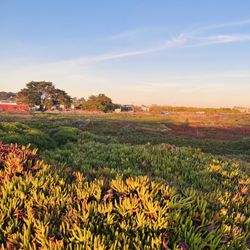
For an impressive waterfall it's pretty mid. But the area around has some trails with nice views of the ocean and beyond. Yelpers have mentioned the trail to the waterfall starts where Westline Dr. and Skyline Dr. meet. From here it's fairly intuitive on where to go. I felt the trail down to the falls seemed too steep to attempt so I opted out. I'm not sure if it was better a few years ago but when I went it felt dangerous and easy to lose footing. I wouldn't recommend this part for someone hiking alone, with kids, or with inexperienced hikers. The trail continues in the other direction along Westline Avenue with views of the ocean. If you continue you can see the top of the waterfall from here. You have to walk a little off the main trail in the ice plant but it's worth it if you want to see the falls. Another way is you can see this waterfall is by walking from Esplanade Beach. From the top of the stairs there the waterfall is about .6 miles. It's so much easier to get to this way and it's a nice beach walk. From here you can't see the waterfall as clear because there is a lot of debris in the way. In this sense it's almost a better view from above. The waterfall comes out of a storm drain which isn't as nice and only flows after a big rain. I wouldn't come out of my way to see this waterfall. But I think it's worth coming to see if you are already at Esplanade Beach or live in the neighborhood and are walking the trail alongside Westline Dr. From the start point to the beach and back it's about a 3.4 mile hike. read more


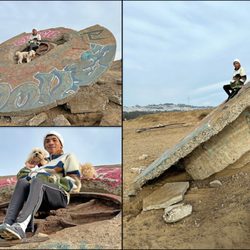
This morning was scatter showers in mid Nov. When the sun came out in the afternoon, we ventured out to this secret fall. Finding the trail head was not so easy but the coordinates are spot on. Across the street from corner of Westline Dr. and Skyline Dr, go a little south to find a section of rocks in cement, the trail head starts there going southwest to the face of the bluff where the first yellow rope lies. Then continue southward to find another yellow rope secured to a rebar within a car tire. (The old blue and orange line was broken) It was a little muddy and slippery today from the rain so the ropes were necessary to aid downward. Going up was much easier. Since this place is not so easy to access, it is quite secluded. We had the whole beach to ourselves. It was fun work to climb down and enjoy this beach with a fresh water ravine. read more


8 years ago
This place has an amazing view. Thanks to a previous Yelper, I was able to find this spot! The only thing missing was the waterfall :(. Bad timing maybe? Bring a set of gloves for the rope that you'll be holding onto while going down the hill side. I managed to find this place last minute & was like "Why not?!" . I wanted to go ALL the way down to the beach but the rope doesn't go down that far. I don't trust my balance so I didn't attempt climbing down without support. Overall, it's worth going. People paraglide in the area so that's pretty awesome alone. read more


8 years ago
Pretty cool waterfall. As of October 10th 2018, there is water coming out. Of course this is the city sewer pipe water but not bad at all. read more


6 years ago
8 years ago
12 years ago
15 years ago
I recently came across this location when I saw a picture of it on flickr. I never knew that there was a waterfall on the border of Daly City/Pacifica so I had to check it out. To get a better idea of where this waterfall is located, input the following coordinates into google earth - (37.661694, -122.492516). If you're driving here, then park your car in the residential area behind the cliff. Then look for the no parking sign on the cliff side that's directly in front of Westline Dr & Skyline Dr. There should be a trail leading down to the beach a little to the left of that no parking sign. There are several trails that LOOK like they easily lead down to the beach, but don't be fooled. Those trails are actually really hard to follow. I tried to go down three different trails before finally finding the correct one. The trail you want to take will have a long rope tied to a stake. You'll need to use that rope to get down and back up the cliff. Once you find this trail then head all the way down to the beach. The waterfall will be to your left (when you're facing the ocean). What's cool about the waterfall is that it's fresh water and it flows directly into the ocean. Another thing that I found interesting was that there were little frogs just chillin in the little streams that the waterfall forms. I'll have pictures up soon, which will hopefully give a better visual for the directions. In the meantime, here's an article on "Pacifica's secret waterfall" that you may be interested in - http://www.sfgate.com/cgi-bin/article.cgi?f=/c/a/2010/03/25/SPJ11CKHJH.DTL. read more


. - Beaches Near Me")
More info about Pacifica's Secret Waterfall
Daly City, CA 94015
Directions
Visit Website
http://www.pacificabeachcoalition.org
Hours
Outdoor Amenities
Ask the Community - Pacifica's Secret Waterfall
Review Highlights - Pacifica's Secret Waterfall
You might also consider


Why does Yelp recommend reviews?
4 reviews that are not currently recommended
The reviews below are not factored into the business's overall star rating.
12 years ago
1 year ago
2 years ago
2 months ago
Pacifica's Secret Waterfall - beaches - Updated May 2026
Best of Daly City
People found Pacifica's Secret Waterfall by searching for…
Things to Do in Daly City, California
Hiking in Daly City, California
Parks in Daly City, California
Paragliding in Daly City, California
Beautiful Views in Daly City, California
Secluded Beaches in Daly City, California
Hiking Trails in Daly City, California
Secret Spots in Daly City, California
Waterfall in Daly City, California
Picnic Spots in Daly City, California
Hidden Spots in Daly City, California
Places to Take Pictures in Daly City, California
Walking Trails in Daly City, California
Hidden Beach in Daly City, California
Picnic Areas in Daly City, California
Dog Beach in Daly City, California
Trail in Daly City, California
Scenic View in Daly City, California
Cliff Jumping in Daly City, California
Views in Daly City, California
Skyline View in Daly City, California
Romantic Views in Daly City, California
Trending Searches in Daly City, CA
Beach Bars near Pacifica's Secret Waterfall
Beach Chair Rentals near Pacifica's Secret Waterfall
Boat Rental near Pacifica's Secret Waterfall
Botanical Gardens near Pacifica's Secret Waterfall
Bounce House Rentals near Pacifica's Secret Waterfall
Campgrounds near Pacifica's Secret Waterfall
Caves near Pacifica's Secret Waterfall
Cherry Picking near Pacifica's Secret Waterfall
Cliff Jumping near Pacifica's Secret Waterfall
Crabbing Location near Pacifica's Secret Waterfall
Dog Friendly Beaches near Pacifica's Secret Waterfall
Fishing Spots near Pacifica's Secret Waterfall
Flower Shop near Pacifica's Secret Waterfall
Garage Sales near Pacifica's Secret Waterfall
Hair near Pacifica's Secret Waterfall
Nurseries & Gardening near Pacifica's Secret Waterfall
Outdoor Furniture Stores near Pacifica's Secret Waterfall
Party Equipment Rentals near Pacifica's Secret Waterfall
Pedicure near Pacifica's Secret Waterfall
Pick Your Own Farms near Pacifica's Secret Waterfall
Picnic Areas near Pacifica's Secret Waterfall
Plant Nursery near Pacifica's Secret Waterfall
Public Shower near Pacifica's Secret Waterfall
River Swimming near Pacifica's Secret Waterfall
Salt Water Pool near Pacifica's Secret Waterfall
Scenic View near Pacifica's Secret Waterfall
Strawberry Picking near Pacifica's Secret Waterfall
Sunbathing near Pacifica's Secret Waterfall
Browse Articles
Browse Nearby
BEST of Daly City, California Things to Do near Pacifica's Secret Waterfall
BEST of Daly City, California Tide Pools near Pacifica's Secret Waterfall
BEST of Daly City, California Coffee near Pacifica's Secret Waterfall
BEST of Daly City, California Restaurants near Pacifica's Secret Waterfall
BEST of Daly City, California Lakes near Pacifica's Secret Waterfall
BEST of Daly City, California Breakfast near Pacifica's Secret Waterfall
BEST of Daly City, California Campgrounds near Pacifica's Secret Waterfall
BEST of Daly City, California Hotels near Pacifica's Secret Waterfall
BEST of Daly City, California Sightseeing near Pacifica's Secret Waterfall
Browse Brands
Related Searches in Daly City, CA
Affordable Paddle Board Rental in Daly City, California
Best Swimming Beach in Daly City, California
Best Water Parks for Kids in Daly City, California
Book a Snorkeling Tour in Daly City, California
Browse Top Hotels in Daly City, California for Your Stay
Discover Dog Friendly Beaches Near Daly City, California
Discover Public Beaches to Visit in Daly City, California
Discover Public Pools Open in Daly City, California
Discover Scenic Beach Camping Sites in Daly City, California
Discover Sea Shell Beaches Near Daly City, California
Discover Walking Parks in Daly City, California Near You
Discover the Best Tide Pools in Daly City, California
Enjoy Surfing Adventures in Daly City, California
Enjoy Water Activities and Fun in Daly City, California
Enjoy a Dog Beach Day in Daly City, California
Enjoy the Best Walking Trails in Daly City, California
Experience Stunning Sunset Views in Daly City, California
Experience Thrilling Parasailing Adventures in Daly City, California
Explore Beautiful Parks and Green Spaces in Daly City, California
Explore Easy Hikes Perfect for All in Daly City, California
Explore Off Leash Dog Beaches in Daly City, California
Explore Popular Campgrounds Near Daly City, California
Explore Scenic Lakes to Visit in Daly City, California
Explore Secluded Beaches to Relax in Daly City, California
Explore Top Dog Parks in Daly City, California Near You
Explore Top Marinas Near Daly City, California
Explore Top Water Parks in Daly City, California Today
Explore the Best Swimming Holes Around Daly City, California
Find Beautiful Views in Daly City, California
Find Free Beach Parking Options in Daly City, California
Find Reliable Beach Chair Rentals in Daly City, California
Find Surf Lessons Near You in Daly City, California
Find Top-Rated Waterfalls in Daly City, California Now
Find the Best Parks for Picnics in Daly City, California
Find the Best Playgrounds to Visit in Daly City, California
Find the Best Swimming Pools in Daly City, California Today
Great Places to Swim in Daly City, California
Popular Fishing Spots to Explore in Daly City, California
Popular Picnic Spots to Visit in Daly City, California
Popular Places to Take Pictures in Daly City, California
Relax at Popular Beach Parks in Daly City, California
Safe Beaches for Kids in Daly City, California
Safe and Fun Parks for Kids in Daly City, California
Top Hiking Trails to Explore in Daly City, California
Top Paddleboarding Activities in Daly City, California
Top Places for Snorkeling in Daly City, California
Top Playgrounds for Kids to Enjoy in Daly City, California
Top Swimming Lakes to Enjoy in Daly City, California