Thornton State Beach Photos


You might also consider
More like Thornton State Beach
Recommended Reviews - Thornton State Beach
Start your review...

Reviews With Photos

Beautiful hike! I've visited this state beach at least 4 times now and today even got lucky with the sunny weather. Just so you know, it's more of appreciating the beauty of the nature while hiking to the beach. It's never crowded, only the packing lot is quite limited. It's worth it though. Many dogs on the trail as well!

Visited for the first time for a trail hike with the dog. Mapping directly to the beach will take you to the parking area, which is a roundabout. From there, you can start walking along designated trails for stunning viewpoints of the ocean. It is more of a cliffside trail and you will be above the water. There probably is a trail that leads down to the beach itself, but we didn't find one yet. The trails are very accessible and not too challenging to walk. Do you still exercise a degree of caution as it is along the cliff and there are moments with moderately small, sharp declines or uneven surface. Dog friendly, which is a huge plus.


I have to be honest and tell you I can't tell where one beach ends and another begins on this stretch of the Pacific Coast between San Francisco, Daly City, and Pacifica. It all melts together as far as I'm concerned, and I'm good with that. Yes, I know there's a small circular parking lot at the end of John Daly Blvd, but I usually get here by way of Fort Funston because the long beach stroll is quite pleasurable and adds more steps to my FitBit. Besides, the parking lot is way bigger. The challenge then becomes how do you get up from the beach to the tall bluff terraces, which represent the real main attraction here. Just by watching the dog walkers traverse the beach, I followed one who used an unmarked rocky path that got me up the cliff with surprising ease. I couldn't really describe where it was except to say when you see the conspicuously pointy stand-alone rock on the beach, you've gone too far (photo: https://bit.ly/3vBqr3V). You can figure it out. I believe in you. Once on top of the bluff terraces, i was in the midst of a network of narrow pathways amid some picturesque flora that can apparently withstand the powerful Pacific winds. Sometimes there was a lonely bench that provided a vista platform for the beach. I have to admit part of my enjoyment came from figuring out how to get back to Fort Funston without having to climb down to the beach. It can be done if you don't mind a few wrong turns along the way since there were no directional signage. That's about as adventurous as I get, y'know. RELATED - Exploring the Pacific side of the peninsula? Here's a collection of places I've visited and reviewed: https://bit.ly/3aiDR9I

Nice going, people, you know these balloons you decided to litter on the beach can kill wildlife? So on July 8, 2023, (or the day before since the balloons were halfway deflated) some people decided to celebrate a family member's graduation, bringing balloons down to the beach at Thornton. They could have also come from Fort Funston. However, they left all their balloons at the beach. I found three and a runner found another 2 closer to where the horses exit onto the beach.

Came to Thornton State Beach on a Sunday afternoon for a birthday get together. Parking was really easy off of John Daly, there's a circular free parking area and luckily there was parking at the beginning of the trail. The trail is really nice but STEEP going towards the beach, it doesn't look like there's a trail but make sure you bring the correct shoes because I was not prepared. It's about a 15 minute trek to get to the beach from the parking lot. The beginning is pretty easy but getting down is a little sandy as well so be sure to bring hiking shoes or just bring extra careful. Because it gets pretty foggy it felt like I was in Europe watching the clouds roll by, I really enjoyed it knowing I was still in the Bay Area! There aren't too many people at the Beach but such a great local find! We went on a Sunday afternoon in June and it did get very cold and windy towards the end so it was good we brought jackets.


Wow, what a nice gem in Daly City! Parking is limited but there's more parking from the street next door that leads to the little pony ranch. Really awesome vistas and great little trails to go into the little valley below and even down to the beach. A word of warning though, there's a lot of erosion for the trail going down to the beach and it's not fully maintained. It's definitely uncrowded down there due to how challenging it is to get down with a couple of steep sections. Definitely coming back but not without good hiking shoes :-)

Really gorgeous views and a nice, short coastal hike. Totally worth a visit. Parking is limited sometimes. If that happens, I just drive further down by a couple of minutes and opt to visit Fort Funston instead (plenty of parking and the trail seems to be better maintained + toilets). One thing to note is to try to avoid the edges. It seems that when I return, some parts have eroded, it I'm not entirely sure if where I'm standing on the edge is "sound." There's also horses that come through this trail, so you'll see horse poop every now and then.

It's nice. It's beautiful. It's calming. Good stuff. I like it here. I like to smoke here. I like to eat here. I like to Become imaginative here. I like it here, I already mentioned that, but I'll mention. It again! To get the statement clear, i enjoy my time here. Not all the time, but most of the time. Yup


Review #311 - 2019 After our semi-disappointing food adventures, I wanted to give my daughter some time to run around the beach and expense some energy from all that sugar that she'd just consumed before we head back home & fight the traffic. We showed up around 1:15 PM on Wednesday, October 30th, and there were actually quite a few cars parked in the Thornton Beach Vista lot so I thought I must be at the right place. We got all ready, grabbed her beach bucket, and a beach mat and made our walk over. We walked straight ahead, passed a beautiful field of wild flowers & grass just to reach a high cliff. I'm sure if we were avid hikers, we could make our way down, but that we are not! However, the view was too beautiful to pass up and not stop for some quick photos! We spent a few minutes taking some nice mother-daughter pictures, then headed to the left to see if we could make our way down to the beach from there. Sadly, we came to another high cliff & were too scared to hike down so we just kept taking more pictures. We can definitely see the beach from way up high, but how do we manage to get down? We had no idea... We still had a good time, nonetheless, and it was such an awesome view that we didn't feel bad about it at all. Maybe we'll have a chance to come back & figure out how to get down to that beach someday, when it's not as windy.

If you've ever been to Fort Funston (in SF) and stand at the deck & enjoy the mountainous views toward your left, it's Thornton State Beach (in Daly City) :) The cool thing about this spot is there isn't one path. You figure it out as you go and you're above the beach. It's a peaceful walk and especially nice on a rare hot day bc of the breeze. Note some paths get really close cliff side so be careful, especially after a rainy day. I believe some people have fallen off the cliff before. I always wondered where on the news by Fort Funston and now I know. read more

Thornton State Beach is a good place to go hiking. Basically, there's almost no one in the beach since I only saw one person. Also, it's very difficult climbing your way down to the beach because of steep elevations. That's why I don't bother going all the way down to the beach. Some trails are harder to pass through. You may need to pick up some rock climbing skills if you want to work your way back up from where you climbed down. In terms of atmosphere, nature isn't really bad and it's as vibrant as it gets. It's not really hard hiking here because most of the time, you don't need to hike through many steep paths, but a very few ones are hard to pass through. Again, you may need to climb your way up from those areas. Overall, most trails are shallow. This park also has its own parking lot, but it's very small making it difficult to find a parking spot. Also, there are no bathrooms here. Make sure that you're well-prepared coming here and be careful hiking there. read more


Such a lovely hike if you want to be near the ocean and get away from it all. For ocean walks I usually have gone to Batteries to Bluffs but this was much more impressive as it's longer with different terrains. There is a maze of paths so there's not a definite way. Utilizing an App like AllTrails can help it make more sense. There are options to hike along the bluff, beach, or more inland which is not as windy. For the longest hike it's best to go from Thronton to Fort Funston, right below Fort Funston there's an impressive sand ladder which is much longer than the Baker Beach one. Great for hot days because there's always a breeze and this area is generally always cold. Sometimes you can see hangliders. It's worth noting there are no bathrooms on the trail. read more


Beautiful hike! I've visited this state beach at least 4 times now and today even got lucky with the sunny weather. Just so you know, it's more of appreciating the beauty of the nature while hiking to the beach. It's never crowded, only the packing lot is quite limited. It's worth it though. Many dogs on the trail as well! read more


1 year ago
Visited for the first time for a trail hike with the dog. Mapping directly to the beach will take you to the parking area, which is a roundabout. From there, you can start walking along designated trails for stunning viewpoints of the ocean. It is more of a cliffside trail and you will be above the water. There probably is a trail that leads down to the beach itself, but we didn't find one yet. The trails are very accessible and not too challenging to walk. Do you still exercise a degree of caution as it is along the cliff and there are moments with moderately small, sharp declines or uneven surface. Dog friendly, which is a huge plus. read more


I have to be honest and tell you I can't tell where one beach ends and another begins on this stretch of the Pacific Coast between San Francisco, Daly City, and Pacifica. It all melts together as far as I'm concerned, and I'm good with that. Yes, I know there's a small circular parking lot at the end of John Daly Blvd, but I usually get here by way of Fort Funston because the long beach stroll is quite pleasurable and adds more steps to my FitBit. Besides, the parking lot is way bigger. The challenge then becomes how do you get up from the beach to the tall bluff terraces, which represent the real main attraction here. Just by watching the dog walkers traverse the beach, I followed one who used an unmarked rocky path that got me up the cliff with surprising ease. I couldn't really describe where it was except to say when you see the conspicuously pointy stand-alone rock on the beach, you've gone too far (photo: https://bit.ly/3vBqr3V). You can figure it out. I believe in you. Once on top of the bluff terraces, i was in the midst of a network of narrow pathways amid some picturesque flora that can apparently withstand the powerful Pacific winds. Sometimes there was a lonely bench that provided a vista platform for the beach. I have to admit part of my enjoyment came from figuring out how to get back to Fort Funston without having to climb down to the beach. It can be done if you don't mind a few wrong turns along the way since there were no directional signage. That's about as adventurous as I get, y'know. RELATED - Exploring the Pacific side of the peninsula? Here's a collection of places I've visited and reviewed: https://bit.ly/3aiDR9I read more


3 years ago
Nice going, people, you know these balloons you decided to litter on the beach can kill wildlife? So on July 8, 2023, (or the day before since the balloons were halfway deflated) some people decided to celebrate a family member's graduation, bringing balloons down to the beach at Thornton. They could have also come from Fort Funston. However, they left all their balloons at the beach. I found three and a runner found another 2 closer to where the horses exit onto the beach. read more


Came to Thornton State Beach on a Sunday afternoon for a birthday get together. Parking was really easy off of John Daly, there's a circular free parking area and luckily there was parking at the beginning of the trail. The trail is really nice but STEEP going towards the beach, it doesn't look like there's a trail but make sure you bring the correct shoes because I was not prepared. It's about a 15 minute trek to get to the beach from the parking lot. The beginning is pretty easy but getting down is a little sandy as well so be sure to bring hiking shoes or just bring extra careful. Because it gets pretty foggy it felt like I was in Europe watching the clouds roll by, I really enjoyed it knowing I was still in the Bay Area! There aren't too many people at the Beach but such a great local find! We went on a Sunday afternoon in June and it did get very cold and windy towards the end so it was good we brought jackets. read more


1 year ago
3 years ago


Wow, what a nice gem in Daly City! Parking is limited but there's more parking from the street next door that leads to the little pony ranch. Really awesome vistas and great little trails to go into the little valley below and even down to the beach. A word of warning though, there's a lot of erosion for the trail going down to the beach and it's not fully maintained. It's definitely uncrowded down there due to how challenging it is to get down with a couple of steep sections. Definitely coming back but not without good hiking shoes :-) read more


Really gorgeous views and a nice, short coastal hike. Totally worth a visit. Parking is limited sometimes. If that happens, I just drive further down by a couple of minutes and opt to visit Fort Funston instead (plenty of parking and the trail seems to be better maintained + toilets). One thing to note is to try to avoid the edges. It seems that when I return, some parts have eroded, it I'm not entirely sure if where I'm standing on the edge is "sound." There's also horses that come through this trail, so you'll see horse poop every now and then. read more

2 years ago
2 years ago
5 years ago
It's nice. It's beautiful. It's calming. Good stuff. I like it here. I like to smoke here. I like to eat here. I like to Become imaginative here. I like it here, I already mentioned that, but I'll mention. It again! To get the statement clear, i enjoy my time here. Not all the time, but most of the time. Yup read more


A really gorgeous beach with sweeping hills and lots of area to explore. Doesn't get as crowded which is a great plus (there is some horse poop, but all good). We found a bunch of sand dollars and some shells walking around. At other ones it gets picked clean. It's definitely a hidden gem. read more


2 years ago
7 years ago
Review #311 - 2019 After our semi-disappointing food adventures, I wanted to give my daughter some time to run around the beach and expense some energy from all that sugar that she'd just consumed before we head back home & fight the traffic. We showed up around 1:15 PM on Wednesday, October 30th, and there were actually quite a few cars parked in the Thornton Beach Vista lot so I thought I must be at the right place. We got all ready, grabbed her beach bucket, and a beach mat and made our walk over. We walked straight ahead, passed a beautiful field of wild flowers & grass just to reach a high cliff. I'm sure if we were avid hikers, we could make our way down, but that we are not! However, the view was too beautiful to pass up and not stop for some quick photos! We spent a few minutes taking some nice mother-daughter pictures, then headed to the left to see if we could make our way down to the beach from there. Sadly, we came to another high cliff & were too scared to hike down so we just kept taking more pictures. We can definitely see the beach from way up high, but how do we manage to get down? We had no idea... We still had a good time, nonetheless, and it was such an awesome view that we didn't feel bad about it at all. Maybe we'll have a chance to come back & figure out how to get down to that beach someday, when it's not as windy. read more


2 years ago
9 years ago
One of my favorite places to decompress. Family & dog friendly, unless you plan on exploring the off beaten paths, those cliff drops are def not intended for the lil ones. Small parking lot that fills up quickly, especially right before sunset. Even on the warmest day, bring a jacket and a beanie. The wind gusts are bone chilling. read more


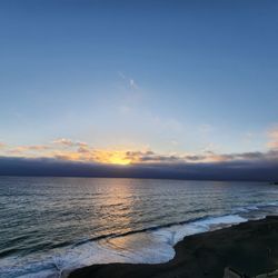
This beach doesn't get crazy crowded like Santa Cruz or Pismo. There's something about this place , peaceful and zen-like. It gets a bit crowded during sunset but not crazy like the other beaches. There's a parking lot ( free). Very nice view of the sunset from the cliffs. You can take the trails down to the beach that's surrounded by rush green valley. read more


My boyfriend is just a whiz at finding these little hidden gems. We were in the area and decided to stop by the Thornton Beach Vista Point. There's a small parking lot (you may have to wait for someone to leave before you park in a spot). Bring a jacket! It gets windy. There is a paved trail to a look out point where you can see the cliffs and the coastline. Starting from the parking lot, there's an unpaved trail (over the rail) that will lead you towards the coast. Keep following the trail and you'll find yourself walking down the side of the hill/cliff and closer to the coastline. From the top of the trail, we enjoyed the view and saw several people parachuting and hang gliding. They looked so peaceful! It was neat to see how they navigated the winds in the sky. There's also a horse ranch or something right near here where people horseback ride down to the coast. Pretty cool! We saw some groups hike all the way down to the beach. There looked like there were several trails that lead you down there (take your pick!) Will probably come back one day to hike down and check it out. read more


6 years ago
One of my favorite spots to go and so close to Daly City. Like every beach in NorCal don't expect to swim there without a wetsuit although I once did it and then I didn't the rest of the day shivering lol. However the views and the hikes around there are amazingly good and there isn't that many people. read more

After driving by so many times, I finally stopped to check out Thornton Beach Vista. Located at the end of John Daly Blvd., Thornton Beach Vista has a similar look and feel to Fort Funston up the road, but it's smaller and less crowded. I think Thornton Beach is a far prettier spot. The ocean views are worth stopping for and you're close enough to hear the waves (but not far enough away to not hear traffic). There are some multi-purpose trails (covered with vegetation, sandy dunes) that seem to wind down closer to the ocean but they haven't been maintained and are badly eroded. The lookout area was recently renovated. They added some interesting signs about the history of the area (e.g., there was a railroad line), including the coastal dune invasion. There are a few benches and garbage cans. Parking is easy. There are no amenities. It's mainly a lookout/observation point. read more


Sure would have been nice to see the beach itself, but as of right now, the vista is the only point that you have access to and can see. The other areas and trails are cordoned off for safety reasons. However, you can still see quite a bit from your vantage point. read more


5 years ago
Really pretty views and a great spot for hiking. Be prepared, to get to the water you have to hike down some pretty steep hills but it's doable. Also not a lot of parking & can get really windy on some days so check the weather before going! read more

8 years ago
Easy to locate, free parking although spots are limited, dog friendly. You can explore the trails among the cliffs below the look out point, or walk along the beach. My boyfriend, dog and I truly enjoyed this last minute hiking spot after visiting family in Daly City. We will be back! read more


8 years ago
9 years ago

7 years ago
13 years ago
10 years ago
13 years ago
13 years ago
14 years ago
Vista is ok. But this review is more for the hike down past the stables and to inbetween the cliff before the beach and the cliff in front of the viewpoint. Amazing little space. Great for kite flying and riding horses. :) read more


Page 1 of 2
More info about Thornton State Beach
Thornton Beach Rd
Daly City, CA 94015
Directions
(831) 335-6318
Call Now
Visit Website
http://www.parks.ca.gov/default.asp?page_id=530
Hours
Indoor Amenities
Outdoor Amenities
Ask the Community - Thornton State Beach
Review Highlights - Thornton State Beach
You might also consider


Why does Yelp recommend reviews?
3 reviews that are not currently recommended
The reviews below are not factored into the business's overall star rating.
2 years ago
11 years ago
14 years ago
Thornton State Beach - beaches - Updated July 2026
Best of Daly City
People found Thornton State Beach by searching for…
Hiking Trails in Daly City, CA
Sea Shell Beaches in Daly City, CA
Horseback Riding on Beach in Daly City, CA
Dog Friendly Beaches in Daly City, CA
Kids Friendly Beaches in Daly City, CA
Beautiful Views in Daly City, CA
Walking Trails in Daly City, CA
Free Beach Parking in Daly City, CA
Crabbing Location in Daly City, CA
Trending Searches in Daly City, CA
Beach Chair Rentals in Daly City, CA
Black Owned Nail Salons in Daly City, CA
Cliff Jumping in Daly City, CA
Crabbing Location in Daly City, CA
Dog Friendly Beaches in Daly City, CA
Jet Ski Rental in Daly City, CA
Public Beaches in Daly City, CA
River Swimming in Daly City, CA
Salt Water Pool in Daly City, CA
Swimming Holes in Daly City, CA
Swimming Lakes in Daly City, CA
Browse Articles
Browse Nearby
BEST of Daly City, California Things to Do near Thornton State Beach
BEST of Daly City, California Tide Pools near Thornton State Beach
BEST of Daly City, California Coffee near Thornton State Beach
BEST of Daly City, California Restaurants near Thornton State Beach
BEST of Daly City, California Lakes near Thornton State Beach
BEST of Daly City, California Breakfast near Thornton State Beach
BEST of Daly City, California Resorts near Thornton State Beach
BEST of Daly City, California Campgrounds near Thornton State Beach
BEST of Daly City, California Hotels near Thornton State Beach
Browse Brands
Related Searches in Daly City, CA
Affordable Paddle Board Rental in Daly City, California
Best Swimming Beach in Daly City, California
Best Water Parks for Kids in Daly City, California
Book a Snorkeling Tour in Daly City, California
Browse Top Hotels in Daly City, California for Your Stay
Discover Dog Friendly Beaches Near Daly City, California
Discover Public Beaches to Visit in Daly City, California
Discover Public Pools Open in Daly City, California
Discover Scenic Beach Camping Sites in Daly City, California
Discover Sea Shell Beaches Near Daly City, California
Discover Walking Parks in Daly City, California Near You
Discover the Best Tide Pools in Daly City, California
Enjoy Surfing Adventures in Daly City, California
Enjoy Water Activities and Fun in Daly City, California
Enjoy a Dog Beach Day in Daly City, California
Enjoy the Best Walking Trails in Daly City, California
Experience Stunning Sunset Views in Daly City, California
Experience Thrilling Parasailing Adventures in Daly City, California
Explore Beautiful Parks and Green Spaces in Daly City, California
Explore Easy Hikes Perfect for All in Daly City, California
Explore Off Leash Dog Beaches in Daly City, California
Explore Popular Campgrounds Near Daly City, California
Explore Scenic Lakes to Visit in Daly City, California
Explore Secluded Beaches to Relax in Daly City, California
Explore Top Dog Parks in Daly City, California Near You
Explore Top Marinas Near Daly City, California
Explore Top Water Parks in Daly City, California Today
Explore the Best Swimming Holes Around Daly City, California
Find Beautiful Views in Daly City, California
Find Free Beach Parking Options in Daly City, California
Find Reliable Beach Chair Rentals in Daly City, California
Find Surf Lessons Near You in Daly City, California
Find Top-Rated Waterfalls in Daly City, California Now
Find the Best Parks for Picnics in Daly City, California
Find the Best Playgrounds to Visit in Daly City, California
Find the Best Swimming Pools in Daly City, California Today
Great Places to Swim in Daly City, California
Popular Fishing Spots to Explore in Daly City, California
Popular Picnic Spots to Visit in Daly City, California
Popular Places to Take Pictures in Daly City, California
Relax at Popular Beach Parks in Daly City, California
Safe Beaches for Kids in Daly City, California
Safe and Fun Parks for Kids in Daly City, California
Top Hiking Trails to Explore in Daly City, California
Top Paddleboarding Activities in Daly City, California
Top Places for Snorkeling in Daly City, California
Top Playgrounds for Kids to Enjoy in Daly City, California
Top Swimming Lakes to Enjoy in Daly City, California
People who viewed Thornton State Beach also viewed
Pacifica's Secret Waterfall
10 reviews
Sharp Park Beach
12 reviews
Ocean Beach
942 reviews
Outer Sunset
Mile Rock Beach
31 reviews
Sea Cliff
Fort Funston
1186 reviews
Lakeshore
Point San Bruno Park
6 reviews
Crissy Field
844 reviews
Presidio
McNee Ranch State Park
92 reviews
Pedro Point Headlands
27 reviews
Roosevelt Beach State Beach
18 reviews