Pedro Point Headlands Photos


You might also consider
More like Pedro Point Headlands
Recommended Reviews - Pedro Point Headlands
Start your review...

Reviews With Photos

Now if you measure your fitness by counting your FitBit steps like I do, you start figuring out places where you can hit your target without having to think about it. I've been to Devil's Slide several times since it was converted into a rolling walking and biking path with spectacular ocean views. It's nice, but frankly I couldn't hit my step target going back and forth from the southern parking lot. That is until quite recently when I discovered the adjoining headlands that helped make me compensate for the lapse. Just beyond the northern trailhead of Devil's Slide was a narrow sidewalk that turned into a dirt trail that went right into the hills. Here it became more rustic and grassy but still well marked. Turning left and gradually walking upward, I found myself on the South Ridge Trail where I could see the highway tunnels and a southward view of Devil's Slide. While the Pacific views were great from the ridge top, this was where I hit a steep decline that had me treading slowly toward Pedro Summit. The best views can be had from the summit as I looked toward Pacifica and beyond. I have to admit another steep downgrade prevented me from going further out to the headland, but for the more adventurous, be my guest. When I came down from the summit. I took the hidden mile-plus Arroyo Trail back to the entry point and entered into a rainforest-like setting with lots of ferns and eucalyptus trees. I eventually made my way back on the Devil's Slide pavement, and by the time I reached the car, my step goal was achieved. Happy days. RELATED - Up for a hike? Here's a collection of trails I've walked and reviewed: http://bit.ly/2OrC8nU

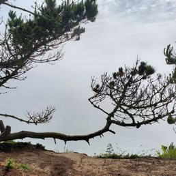
What a beautiful easy short hike! Been back living in Pacifica for two months and have already hiked Pedro Point headlands three times. Short (maybe 3 miles loop) trail out the the headlands offers some great views down Devil's slide, Pedro rock/Point, Shelter Cove, Linda Mar, and the Golden Gate Bridge on a clear day. Go enjoy this great views trail.

We hiked Devil's Slide and just kept going - that's how we ended up here! Nice variety of trails, not busy at all, stunning views. The map at the trailhead shows the Middle Ridge Trail ends abruptly, but it actually does loop down and join the Arroyo Trail. PARKING Use the Devil's Slide North lot. It has ~8 spots in the main lot and one handicap spot, ~4 spots in a smaller lot. AMENITIES: Restrooms at the North lot, pretty clean. Around 5:30 p.m. we saw a ranger cleaning the bathrooms. LEVEL OF DIFFICULTY Not a lot of elevation change, but there are a decent amount of ups and downs so you can get your heart rate up! TIME SPENT HIKING With two babies and a dog (ie a slow pace and plenty of stops), we were did about 3 miles in Pedro Point Headlands and it took a couple hours. SHADE/COVERAGE Parts have shade, particularly the Middle Ridge and Arroyo Trails. The South Ridge and Bluff Trails are both pretty exposed.

Probably one of the most challenging things is finding parking as the only lot is the Devils Slide Trail North Parking Lot and a smaller lot closer to the trailhead that allows for about 12 cars total. We waited about 10-15 minutes and eventually parked in the Devils Slide Trail South Lot and added the 1.3 mile Devils Slide Coastal Trail to our itinerary. I would rate is a moderate hike, because there is a fair bit of incline and decline along the trail. I highly recommend hiking shoes as the trail can be a bit slippery due to the loose rocks when descending along parts of the trail. Round-trip from the entrance to the end of the bluff and back was about 3 miles. Like typical Pacifica weather, your views are super dependent on whether you are fortunate to have clear skies as cloud coverage is the norm. Recommend having a couple of extra layers as temperatures are a bit cooler. Overall, it's a nice place to hike, but given the issues with parking, I'd probably look at other locations during peak hours.
An amazing hike from Rockaway Beach. Park in the little town of Rockaway Beach, cut over the hill tops, walk down the beach, cut through the parking lot at grocery outlet bargain market, then ascend the hill to Pedro point. It's a great hike 4 getting your heart rate up, but it's not too steep. And the view from the top of Pedro point is one of the best in California.

As someone that generally doesn't seek outdoor adventure, I have to say that this hike that has it all. We went towards the end of July and we were treated to colorful wildflowers, a foggy view of the beach from the cliffs, a stint through a valley, and ended up in a eucalyptus forest. For the most part (except for a short cut which you can opt to take) the trail is a loop beginning from the trail head which is accessible off of Cabrillo. There was a native plant nursery and some signage indicating the start of the hike. There's very clear trail markers throughout the hike which are easy to understand. There are parts of the hike that can be a little steep going down with gravel causing some slippery conditions, so be aware of that and wear proper shoes. It's not too strenuous although the start is mostly uphill. We specifically looked for a hike that wasn't too busy. We passed a few other couples on the way but most of the time it was just you and nature which was really nice.
Moderate hiking trail with nice views of the town and the ocean. The trail itself is not very long and does have a few elevation changes but is not strenuous. A few things to keep in mind: - Wear hiking shoes / shoes with good tread / bring hiking sticks. There are a lot of down slope sections with loose gravel/sand that is fairly slippery. - Lots of poison oak around, avoid straying off marked trails. - Parking lot is a bit small at the Devil's Slide north parking lot, but you can continue down the road past the tunnel on 1 South and try parking at the south lot. You'll get to add on the Devil's Slide Trail to your hike.

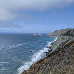
Here's one you probably never heard of. It's not promoted anywhere, and you have to know where to find it in order to get in. It looks like it was thrown open, saying "use at your own risk" (there are no guardrails or stairsteps). But it is public property, ours to enjoy. You'll enjoy it most if you're in shape. I went on the South Ridge trail on the same day that I hiked the Devil's Slide trail. And although I didn't wear myself out, I can see how people can get worn out. It's all uphill, kinda steep, and you wonder when it's gonna end. Once it ends, you do get some gorgeous views, from a perspective that you can't get from anywhere else. It's on the southern edge of the foggiest city in California, so don't expect hot weather. Pedro Point is a good place to go to say that you went there, especially if you ate a lot at Gorilla Barbecue and need to burn it off. If there's a group of you arguing about a different place to hike, then Vote For Pedro.

I'm surprised that Pedro Point is not more known because I was searching on Google Maps for a less crowded place to hike over a three-day weekend and came across this set of trails. It's located between Mori Point and Half Moon Bay so if you're searching for a relatively easy coastal hike, I would definitely recommend this. There is a decent amount of parking near Devil's Slide Coastal Trail and enough ground to cover for a few hours of hiking. The trails are clearly marked, and they all form a loop, so it's hard to get lost. Some parts can be a little steep with loose gravel, but there is no climbing involved. I'm a terribly inexperienced hiker, and I thought this hike was fine. The view of the ocean from Pacifica is absolutely breathtaking. Just enjoy every moment (and take photos if you would like) on your way up to Pedro Summit. Plenty to see in plenty of time. It's so peaceful up here, I might just hike this again!

A pretty nice endeavor. This place is right next to Devil's Slide and get's you a different, very very nice view of Pacifica. The "summit" gives you a beautiful view of the ocean, linda mar beach, and the surrounding mountains. During the walk, there is plenty of green along the way. There is a pretty decent view of a few different landscapes. Overall a pretty nice view. In terms of hiking, it was an odd combination of short, but tough terrain. Lots of steep hills of dirt trails with lots of rocks. It goes up and down a couple of times, so I suggest bringing the right shoes (as much traction as possible: hiking boots would probably be preferable). This is probably like a 2-3 mile hike round-trip from the Devil's Slide parking lot. The dirt can probably get really muddy and slippery after a rain, so just keep this in mind. But on a sunny day, this is a good quick hike with a nice view at the end.

Wow, Can you imagine that nice hiking trails like Pedro Point is only a short drive away from the city? Recently, my girlfriend and I were looking up places to hike along the peninsula and a group of trails in Pacifica appeared on our radar. We had never been to this area of the Bay Area before - only driven through it to San Francisco - and so we decided to give the area a look. Pacific has a few hiking trails to explore for those interested: Devil's Slide, Mori Point, and Pedro's Point. The beauty of it is that all of them are clustered together, and so you don't actually have to keep driving and finding parking; walking to the trailhead is just another hike! And so this review is for Pedro Point Headlands. The trailhead is actually super close to the North parking lot at Devil's Slide, and so you can knock both of them out of the way like us! This hike is around 3 miles at the most round trip and it will take you an estimated time of approximately 2 hours or so? For those who are wondering, there is a good amount of change in elevation, and so you will be working those calves a ton. One of the positives of the Pedro Point trail is that there's a decent mix of nature, given how short the trail is. In some parts you will be covered by shade, and in other parts, you will be wedged between overgrown brush. Another great thing is that it's nearly impossible to get lost. This trail takes you directly to the tippy top and back, with no other detour routes (unless you make one). The most fulfilling part of the hike is making it to the top and getting a view of the surrounding water and city of Pacifica. Sit back, relax and rejoice in your accomplishment before mustering the energy to climb back down. Overall, I give this place a "nice-su, you can take your parents and they'll be happy" rating. I had a good time, the hike is close to other trails and you get a good view at the end. But other than a great and quick workout up, there's not much else to see. Have fun and prosper,
")
2014 Update...Share the secret. Respect the secret. Lots more parking now that Devil's Slide Coastal Trail opened. Park there (north end parking) if you can't park next to the green gate. Took Arroyo Trail, then to Middle Ridge trail to Bluff Trail up to summit. Then going back down we took South Ridge Trail back to start. Trails form a loop, so hard to get lost. We ate lunch at the summit and enjoyed the ocean view from up above. Although foggy, it was still a great view. It was a really easy hike. Just watch your footing. One can easily trip on loose rocks. Please respect the trail and stay on it. Some parts are close to the edge with steep drastic falls down into the ocean. If you include a hike up and down Devil's Slide Coastal trail then up to Pedro summit all in all it took us about 3 hrs to 3 and a 1/2 hours. Take it slow. Enjoy the view :)

This is one of my favorite new hikes - truly a hidden gem. This park has beautiful trails hugging the bluffs with panoramic views of the ocean. It also offers great lookout points to whale watch. The main trail is steep and you'll get a great workout heading to the top, but once you do you'll be rewarded with gorgeous ocean views. The trails are all lush and green, even in summer, with vibrant green moss-covered trees. You'll have views of the rock formations San Pedro Point and Egg Rock. There are 5 parking spots right before Devil's Slide tunnel, off of Highway 1. There are also a few more a little further down, but parking is sparse. From the parking across from Devil's Slide, look down Highway 1 (away from Devil's Slide) and you will see a ramp gently sloping uphill. Take this ramp and you will soon see a brown welcome sign. Head uphill via the narrow trail and you will come to a large bulletin board with information. Head past it and you will see a trailhead sign for the South Ridge Trail. Take this steep trail to the top and you'll have several trails along the bluffs to explore.

Parking is at Devil's Slide which has about 6 spots. The starting trail (South Ridge Trail) is mostly uphill for about a mile. It's not super steep but it's uphill the whole way. It comes to an area to look out at the beautiful Pacific. From there the trail descends sharply. This part I feel you'd really need hiking boots for it, as it was rocky and easy to slip. I even saw some people turn around at this point. It's not something for people looking for a casual stroll so from here you can turn around. If you brave this steep part, it brings you to a clearing that is breathtaking, looking out for miles. The water is so much bluer after the immediate coast and you can see downtown Pacifica's beaches, the elusive Shelter Cove, the bridge, and all the way to Marin. The hike is around 2.5 miles but if you want something longer you can take the Ace Trail which starts on the side of Ace Hardware which makes the hike a little under 4 miles. There terrain is totally different here as it's ensconced and trees and foliage. I like this trail other than the fact that it runs parallel to the freeway so you can always hear cars in the distance. This might be a better option for the weekend because there's more parking over here. On the way back, currently the Middle Ridge Trail is closed for habitat restoration. There is a sign telling you this but I later I connected to this trail from Arroyo Trail where there was no sign and took the second half of this trail. It was very overgrown and a little dangerous, so I'd recommend this hike as an out and back and not a loop. There isn't really any shade, thankfully Pacifica is always cool and foggy. This trail would be difficult on a hot day. This hike is beautiful but it's more strenuous than I thought it would be. If you want something easier and less steep hills, I'd recommend the Devil's Slide hike in the same parking lot because you get the same stellar ocean views with a very gradual grade. read more


1 month ago
Point Venture 255 acres of wild headlands that sit nestled between the City of Pacifica and Devil's Slide and lies over 400' above the ocean below. The Good: *Free! My favorite price. :) *±3miles of trails with a 2.3-mile loop. *Best way to access Pedro Point is to park in the Devil's Slide North Parking Lot. However, if you want a slightly longer hike, then park at the Devil's Slide South Lot, and you'll gain an extra couple of miles on your journey. *Spectacular views *Trails are in fairly decent condition, especially when compared to nearby Mori Point. *Dog-friendly trails *Great place to take kids to get them acquainted with hiking as there's a big payoff with little effort. The Meh: *Check weather conditions, as if it's going to be foggy, then you ain't gonna see much in the way of views, but it will make for an interesting hike. =) The Ugly: *Parking at the Devil's Slide lots could be difficult, as they can be pretty popular, but the South Lot is bigger than the North Lot fwiw. However, as stated above, it will extend your hike by a few miles. TLDR: Fantastic views, fairly easy trails, and free. What more could you want?? If you've read this far then you deserve a secret: you can also access Pedro Point via a trail by the Ace Hardware on San Pedro Ave, but you didn't hear that from me, playa... read more


Now if you measure your fitness by counting your FitBit steps like I do, you start figuring out places where you can hit your target without having to think about it. I've been to Devil's Slide several times since it was converted into a rolling walking and biking path with spectacular ocean views. It's nice, but frankly I couldn't hit my step target going back and forth from the southern parking lot. That is until quite recently when I discovered the adjoining headlands that helped make me compensate for the lapse. Just beyond the northern trailhead of Devil's Slide was a narrow sidewalk that turned into a dirt trail that went right into the hills. Here it became more rustic and grassy but still well marked. Turning left and gradually walking upward, I found myself on the South Ridge Trail where I could see the highway tunnels and a southward view of Devil's Slide. While the Pacific views were great from the ridge top, this was where I hit a steep decline that had me treading slowly toward Pedro Summit. The best views can be had from the summit as I looked toward Pacifica and beyond. I have to admit another steep downgrade prevented me from going further out to the headland, but for the more adventurous, be my guest. When I came down from the summit. I took the hidden mile-plus Arroyo Trail back to the entry point and entered into a rainforest-like setting with lots of ferns and eucalyptus trees. I eventually made my way back on the Devil's Slide pavement, and by the time I reached the car, my step goal was achieved. Happy days. RELATED - Up for a hike? Here's a collection of trails I've walked and reviewed: http://bit.ly/2OrC8nU read more


What a beautiful easy short hike! Been back living in Pacifica for two months and have already hiked Pedro Point headlands three times. Short (maybe 3 miles loop) trail out the the headlands offers some great views down Devil's slide, Pedro rock/Point, Shelter Cove, Linda Mar, and the Golden Gate Bridge on a clear day. Go enjoy this great views trail. read more

We hiked Devil's Slide and just kept going - that's how we ended up here! Nice variety of trails, not busy at all, stunning views. The map at the trailhead shows the Middle Ridge Trail ends abruptly, but it actually does loop down and join the Arroyo Trail. PARKING Use the Devil's Slide North lot. It has ~8 spots in the main lot and one handicap spot, ~4 spots in a smaller lot. AMENITIES: Restrooms at the North lot, pretty clean. Around 5:30 p.m. we saw a ranger cleaning the bathrooms. LEVEL OF DIFFICULTY Not a lot of elevation change, but there are a decent amount of ups and downs so you can get your heart rate up! TIME SPENT HIKING With two babies and a dog (ie a slow pace and plenty of stops), we were did about 3 miles in Pedro Point Headlands and it took a couple hours. SHADE/COVERAGE Parts have shade, particularly the Middle Ridge and Arroyo Trails. The South Ridge and Bluff Trails are both pretty exposed. read more

5 years ago
Probably one of the most challenging things is finding parking as the only lot is the Devils Slide Trail North Parking Lot and a smaller lot closer to the trailhead that allows for about 12 cars total. We waited about 10-15 minutes and eventually parked in the Devils Slide Trail South Lot and added the 1.3 mile Devils Slide Coastal Trail to our itinerary. I would rate is a moderate hike, because there is a fair bit of incline and decline along the trail. I highly recommend hiking shoes as the trail can be a bit slippery due to the loose rocks when descending along parts of the trail. Round-trip from the entrance to the end of the bluff and back was about 3 miles. Like typical Pacifica weather, your views are super dependent on whether you are fortunate to have clear skies as cloud coverage is the norm. Recommend having a couple of extra layers as temperatures are a bit cooler. Overall, it's a nice place to hike, but given the issues with parking, I'd probably look at other locations during peak hours. read more


An amazing hike from Rockaway Beach. Park in the little town of Rockaway Beach, cut over the hill tops, walk down the beach, cut through the parking lot at grocery outlet bargain market, then ascend the hill to Pedro point. It's a great hike 4 getting your heart rate up, but it's not too steep. And the view from the top of Pedro point is one of the best in California. read more


7 years ago
As someone that generally doesn't seek outdoor adventure, I have to say that this hike that has it all. We went towards the end of July and we were treated to colorful wildflowers, a foggy view of the beach from the cliffs, a stint through a valley, and ended up in a eucalyptus forest. For the most part (except for a short cut which you can opt to take) the trail is a loop beginning from the trail head which is accessible off of Cabrillo. There was a native plant nursery and some signage indicating the start of the hike. There's very clear trail markers throughout the hike which are easy to understand. There are parts of the hike that can be a little steep going down with gravel causing some slippery conditions, so be aware of that and wear proper shoes. It's not too strenuous although the start is mostly uphill. We specifically looked for a hike that wasn't too busy. We passed a few other couples on the way but most of the time it was just you and nature which was really nice. read more


Moderate hiking trail with nice views of the town and the ocean. The trail itself is not very long and does have a few elevation changes but is not strenuous. A few things to keep in mind: - Wear hiking shoes / shoes with good tread / bring hiking sticks. There are a lot of down slope sections with loose gravel/sand that is fairly slippery. - Lots of poison oak around, avoid straying off marked trails. - Parking lot is a bit small at the Devil's Slide north parking lot, but you can continue down the road past the tunnel on 1 South and try parking at the south lot. You'll get to add on the Devil's Slide Trail to your hike. read more


Here's one you probably never heard of. It's not promoted anywhere, and you have to know where to find it in order to get in. It looks like it was thrown open, saying "use at your own risk" (there are no guardrails or stairsteps). But it is public property, ours to enjoy. You'll enjoy it most if you're in shape. I went on the South Ridge trail on the same day that I hiked the Devil's Slide trail. And although I didn't wear myself out, I can see how people can get worn out. It's all uphill, kinda steep, and you wonder when it's gonna end. Once it ends, you do get some gorgeous views, from a perspective that you can't get from anywhere else. It's on the southern edge of the foggiest city in California, so don't expect hot weather. Pedro Point is a good place to go to say that you went there, especially if you ate a lot at Gorilla Barbecue and need to burn it off. If there's a group of you arguing about a different place to hike, then Vote For Pedro. read more


11 years ago
I'm surprised that Pedro Point is not more known because I was searching on Google Maps for a less crowded place to hike over a three-day weekend and came across this set of trails. It's located between Mori Point and Half Moon Bay so if you're searching for a relatively easy coastal hike, I would definitely recommend this. There is a decent amount of parking near Devil's Slide Coastal Trail and enough ground to cover for a few hours of hiking. The trails are clearly marked, and they all form a loop, so it's hard to get lost. Some parts can be a little steep with loose gravel, but there is no climbing involved. I'm a terribly inexperienced hiker, and I thought this hike was fine. The view of the ocean from Pacifica is absolutely breathtaking. Just enjoy every moment (and take photos if you would like) on your way up to Pedro Summit. Plenty to see in plenty of time. It's so peaceful up here, I might just hike this again! read more

A pretty nice endeavor. This place is right next to Devil's Slide and get's you a different, very very nice view of Pacifica. The "summit" gives you a beautiful view of the ocean, linda mar beach, and the surrounding mountains. During the walk, there is plenty of green along the way. There is a pretty decent view of a few different landscapes. Overall a pretty nice view. In terms of hiking, it was an odd combination of short, but tough terrain. Lots of steep hills of dirt trails with lots of rocks. It goes up and down a couple of times, so I suggest bringing the right shoes (as much traction as possible: hiking boots would probably be preferable). This is probably like a 2-3 mile hike round-trip from the Devil's Slide parking lot. The dirt can probably get really muddy and slippery after a rain, so just keep this in mind. But on a sunny day, this is a good quick hike with a nice view at the end. read more

Wow, Can you imagine that nice hiking trails like Pedro Point is only a short drive away from the city? Recently, my girlfriend and I were looking up places to hike along the peninsula and a group of trails in Pacifica appeared on our radar. We had never been to this area of the Bay Area before - only driven through it to San Francisco - and so we decided to give the area a look. Pacific has a few hiking trails to explore for those interested: Devil's Slide, Mori Point, and Pedro's Point. The beauty of it is that all of them are clustered together, and so you don't actually have to keep driving and finding parking; walking to the trailhead is just another hike! And so this review is for Pedro Point Headlands. The trailhead is actually super close to the North parking lot at Devil's Slide, and so you can knock both of them out of the way like us! This hike is around 3 miles at the most round trip and it will take you an estimated time of approximately 2 hours or so? For those who are wondering, there is a good amount of change in elevation, and so you will be working those calves a ton. One of the positives of the Pedro Point trail is that there's a decent mix of nature, given how short the trail is. In some parts you will be covered by shade, and in other parts, you will be wedged between overgrown brush. Another great thing is that it's nearly impossible to get lost. This trail takes you directly to the tippy top and back, with no other detour routes (unless you make one). The most fulfilling part of the hike is making it to the top and getting a view of the surrounding water and city of Pacifica. Sit back, relax and rejoice in your accomplishment before mustering the energy to climb back down. Overall, I give this place a "nice-su, you can take your parents and they'll be happy" rating. I had a good time, the hike is close to other trails and you get a good view at the end. But other than a great and quick workout up, there's not much else to see. Have fun and prosper, read more


12 years ago
2014 Update...Share the secret. Respect the secret. Lots more parking now that Devil's Slide Coastal Trail opened. Park there (north end parking) if you can't park next to the green gate. Took Arroyo Trail, then to Middle Ridge trail to Bluff Trail up to summit. Then going back down we took South Ridge Trail back to start. Trails form a loop, so hard to get lost. We ate lunch at the summit and enjoyed the ocean view from up above. Although foggy, it was still a great view. It was a really easy hike. Just watch your footing. One can easily trip on loose rocks. Please respect the trail and stay on it. Some parts are close to the edge with steep drastic falls down into the ocean. If you include a hike up and down Devil's Slide Coastal trail then up to Pedro summit all in all it took us about 3 hrs to 3 and a 1/2 hours. Take it slow. Enjoy the view :) read more
 - Hiking Near Me")
 - Hiking Near Me")


10 years ago
This is one of my favorite new hikes - truly a hidden gem. This park has beautiful trails hugging the bluffs with panoramic views of the ocean. It also offers great lookout points to whale watch. The main trail is steep and you'll get a great workout heading to the top, but once you do you'll be rewarded with gorgeous ocean views. The trails are all lush and green, even in summer, with vibrant green moss-covered trees. You'll have views of the rock formations San Pedro Point and Egg Rock. There are 5 parking spots right before Devil's Slide tunnel, off of Highway 1. There are also a few more a little further down, but parking is sparse. From the parking across from Devil's Slide, look down Highway 1 (away from Devil's Slide) and you will see a ramp gently sloping uphill. Take this ramp and you will soon see a brown welcome sign. Head uphill via the narrow trail and you will come to a large bulletin board with information. Head past it and you will see a trailhead sign for the South Ridge Trail. Take this steep trail to the top and you'll have several trails along the bluffs to explore. read more


8 years ago


6 years ago
We came on a Sunday afternoon and had no problem with parking although there were only around 5 spots near the trail head. We only encounter one other group the whole time hiking so it was really quiet and nice. The hike itself is fairly easy, only slight inclines and trails could get muddy at some sections, so wear shoes with good grip if not hiking shoes. There are areas with lots of bugs though, I was afraid I would swallow some of them. There are many different trails, so we tried different trails on the way there and back, which was nice. One trail was more exposed with steeper inclines, while there was another trail that is more shaded and flatter, which was like walking through a forest. I would recommend trying this because you can have 2 different experiences! You can see the ocean on the way to the summit, but it gets hot while walking through the valley. At the Pedro Point summit, the view is amazing! You can see the coast off of Pacifica and feel the cool breeze. The view almost reminded me of Hawaii. This is an easy hike with great view, excellent for a short outdoor adventure. Although I like to hike different places each time, I don't mind coming here again! read more


16 years ago
8 years ago
Fun hike, a bit dangerous if you go off the beaten path but that makes it more fun too lol. The scenery is pretty, although you don't see much of the ocean it's very quiet and relaxing. Early in the morning is most peaceful and it's a good workout too,) bring proper shoes, I used my workout shoes). read more


8 years ago
13 years ago
10 years ago
13 years ago
More info about Pedro Point Headlands
Ask the Community - Pedro Point Headlands
Are dogs allowed here?
Review Highlights - Pedro Point Headlands
You might also consider


Why does Yelp recommend reviews?
Pedro Point Headlands - hiking - Updated June 2026
Best of Pacifica
People found Pedro Point Headlands by searching for…
Beaches in Pacifica, California
Hiking Trails in Pacifica, California
Photo Spots in Pacifica, California
Beautiful Views in Pacifica, California
Free Beach Parking in Pacifica, California
Scenic View in Pacifica, California
Walking Trails in Pacifica, California
Hidden Spots in Pacifica, California
Things to Do in Pacifica, California
View Points in Pacifica, California
Kid Friendly Beaches in Pacifica, California
Off Road Trails in Pacifica, California
Picnic Areas BBQ Pits in Pacifica, California
Secret Spots in Pacifica, California
Dog Friendly Hiking Trails in Pacifica, California
Dirt Bike Riding in Pacifica, California
Scenic Drive in Pacifica, California
Picnic Spots in Pacifica, California
Stroller Friendly Hikes in Pacifica, California
Playgrounds in Pacifica, California
Waterfall Hike in Pacifica, California
Trending Searches in Pacifica, CA
Baseball Fields near Pedro Point Headlands
Beaches near Pedro Point Headlands
Black Owned Nail Salons near Pedro Point Headlands
Boardwalk near Pedro Point Headlands
Boat Rental near Pedro Point Headlands
Cliff Jumping near Pedro Point Headlands
Creeks near Pedro Point Headlands
Day Trips near Pedro Point Headlands
Dog Friendly Beaches near Pedro Point Headlands
Fishing Spots near Pedro Point Headlands
Free Kids Activities near Pedro Point Headlands
Free Picnic Areas near Pedro Point Headlands
Jet Ski Rental near Pedro Point Headlands
Kids Activities Outdoor near Pedro Point Headlands
Lakes near Pedro Point Headlands
Lakes & Ponds near Pedro Point Headlands
Off Road Trails near Pedro Point Headlands
Outdoor Activities near Pedro Point Headlands
Outdoor Basketball Courts near Pedro Point Headlands
Parks With Pull Up Bars near Pedro Point Headlands
Pick Your Own Farms near Pedro Point Headlands
Places To Walk Around near Pedro Point Headlands
Public Beaches near Pedro Point Headlands
Public Shower near Pedro Point Headlands
Rock Quarry near Pedro Point Headlands
Scenic Drive near Pedro Point Headlands
Scenic Night View near Pedro Point Headlands
Secluded Spots near Pedro Point Headlands
Soccer Store near Pedro Point Headlands
Splash Pad near Pedro Point Headlands
Strawberry Picking near Pedro Point Headlands
Sunrise View near Pedro Point Headlands
Swimming Holes near Pedro Point Headlands
Swimming Lakes near Pedro Point Headlands
Swimming Pools near Pedro Point Headlands
View Fireworks near Pedro Point Headlands
Watch Sunset near Pedro Point Headlands
Browse Nearby
BEST of Pacifica, California Coffee near Pedro Point Headlands
BEST of Pacifica, California Restaurants near Pedro Point Headlands
BEST of Pacifica, California Things to Do near Pedro Point Headlands
BEST of Pacifica, California Breakfast near Pedro Point Headlands
BEST of Pacifica, California Walking Trails near Pedro Point Headlands
BEST of Pacifica, California Parks near Pedro Point Headlands
BEST of Pacifica, California Hot Springs near Pedro Point Headlands
BEST of Pacifica, California Campgrounds near Pedro Point Headlands
BEST of Pacifica, California Sightseeing near Pedro Point Headlands
Browse Brands
Related Searches in Pacifica, CA
Affordable Kayak Rental Services in Pacifica, California
Best Fishing Locations and Guides in Pacifica, California
Best Nature Trails for Hiking in Pacifica, California
Best Off Leash Dog Parks in Pacifica, California
Best Parks for Parties and Events in Pacifica, California
Best Places for Horseback Riding in Pacifica, California
Best Water Parks for Kids in Pacifica, California
Best Waterfalls and Swimming Holes in Pacifica, California
Check Out Great Playgrounds in Pacifica, California
Check Out Off Road Trails in Pacifica, California
Discover Baseball Fields Around Pacifica, California
Discover Beautiful Garden Spots in Pacifica, California
Discover Dog Friendly Trails to Explore in Pacifica, California
Discover Fun Toddler Parks in Pacifica, California for Your Little One
Discover Kid Friendly Hiking Trails in Pacifica, California
Discover Lakes & Ponds to Explore in Pacifica, California
Discover Popular Photo Spots in Pacifica, California
Discover Public Beaches to Visit in Pacifica, California
Discover Scenic Hiking Trails in Pacifica, California
Discover Scenic Mountain Bike Trails Near Pacifica, California
Discover Scenic Waterfall Spots in Pacifica, California
Discover Soccer Fields in Pacifica, California Near You
Discover Top State Parks to Visit in Pacifica, California
Discover Walking Parks in Pacifica, California Near You
Discover a Hiking Trail in Pacifica, California
Discover the Best Beaches in Pacifica, California
Discover the Best Kids Park Spots in Pacifica, California
Discover the Best Night Hike Trails in Pacifica, California
Discover the Best Running Track in Pacifica, California
Dog-Friendly Hikes With Dogs in Pacifica, California
Enjoy Camping Adventures Around Pacifica, California
Enjoy Kayaking Adventures in Pacifica, California
Enjoy Tent Camping Spots Around Pacifica, California
Enjoy a Beautiful Waterfall Hike in Pacifica, California
Enjoy the Best Picnic Spots and Ideas in Pacifica, California
Enjoy the Best Walking Path in Pacifica, California
Enjoy the Best Walking Trails in Pacifica, California
Explore Beautiful Botanical Gardens in Pacifica, California
Explore Beautiful Parks and Green Spaces in Pacifica, California
Explore Easy Hikes Perfect for All in Pacifica, California
Explore Family-Friendly Zoos and Wildlife in Pacifica, California
Explore Free Picnic Areas Around Pacifica, California
Explore Fun Activities to Do in Pacifica, California
Explore Parks With Pull Up Bars in Pacifica, California
Explore Popular Campgrounds Near Pacifica, California
Explore Popular Picnic Areas Around Pacifica, California
Explore Popular RV Parks Around Pacifica, California
Explore Popular Recreation Centers Around Pacifica, California