San Andreas Trail Photos


You might also consider
More like San Andreas Trail
Recommended Reviews - San Andreas Trail
Start your review...

Reviews With Photos

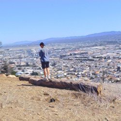
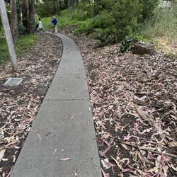
Now that I've conquered all twelve miles of the Sawyer Camp Trail along the length of Crystal Springs Reservoir, I thought I should try the northbound trail along San Andreas Lake. I simply parked at the same place, the 280 underpass at the end of Hillcrest Blvd., got out of the car, and headed right instead of left. You can tell I'm a professional hiker, can't you? Probably by the way I shrieked in a most girlish fashion at the rattlesnake warning sign that was precariously stapled onto an uncommitted barrier (photo: http://bit.ly/2Ohjtcs). Unfortunately I was all out of antivenom. Like I'd know how to use it. The first half-mile of the trail was pure gravel and weeds which made possible reptile sightings next to impossible. I found relief coming out of the semi-wilderness and following the winding pavement which afforded some lovely views of the lake (photo: http://bit.ly/2qjGIZU). My mild frustration with the trail came on either side of the trail. A wire fence provided a constant barrier to the lake visually and physically. On the other side was the cacophony of freeway traffic on 280. Regardless, it's a sturdy five-plus mile walk to and fro, but do be mindful of those rattlers. RELATED - Up for a hike? Here are the places around the Bay Area where I have trod: bit.ly/2OsCCsK

Lush Green at this time of the year !! Lake does has water and Standing on one of the Earthquake Fault Line gives goosebumps. Its very beautiful with lake on one side and lush green valley overlooking towards halfmoon bay. we did complete 6 miles sawyer camp recreation trail. Trail does goes next to 280 so it does gets noisy but perfect trail to put in your headphones and Run!! Along the trail we did see poison oak so be on lookout Parking is limited and it does get windy by the Dam so carry jackets n hoody :)

This trail starts at the intersection of San Bruno Ave and Skyline Blvd. Some people park at the lot across from Arco Storage as opposed to the uneven dirt path designated as San Andreas parking. I usually park at the 280 underpass at Larkspur. More spaces are available here as opposed to the underpass at Hillcrest. I think more people like to start at the North Trailhead of Sawyer Camp Trail and work southbound going down towards the springs. The entire distance round trip is about 5 miles from San Bruno to Hillcrest -- mostly paved, with some inclines, moderate for running, easy for walking. The recreational trail from Larkspur to Hillcrest is dirt path and forested. Sometimes people skip this part and just stick to the paved part of San Andreas and that's an easy 4 mile round trip. What I appreciate most about this trail is the bathroom accessibility. It's still a porta potty type of situation but at least you don't have to hide in the bushes when you're desperate!

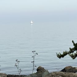
San Andreas Trail is extremely functional. It has good length (running essentially from San Bruno Ave. to Crystal Springs Rd., but further linking up there with Sawyer Camp Trail), easy grading (generally flat or gently-sloped), is mostly paved, and can be accessed quickly from adjacent Skyline Blvd or I-280. It's very stroller-friendly (wide enough even for wheelchairs, actually), and is also used by walkers, joggers and bicyclists. So, utility marks are high. Beyond that, things are "perfect from afar, but far from perfect". Yes, it's next to beauty; there are two reservoirs and expansive green space running along its western edge. But the eastern edge is all-cars-all-the-time; the adjacent roadways create nearly constant traffic noise, with the corresponding vehicles frequently visible. Whether you look left or right will completely change the experience. Or, you could look up. Then, you'd spy the enormous high-voltage transmission line between the trail and the reservoirs, looming over you continuously. Even if you, unlike me, don't wonder repeatedly if your brain is being cooked remotely, it's still plenty f'ugly. And it's undeniably a utility corridor first and nature trail second; if you have any doubts, check out the chainsawed stumps and treetops along the way, presumably victims of line maintenance clearing. Again, it's a very useful trail, and I'm happy it's there, even given the occasional brush-back by an unrelenting cyclist. But I prefer things a bit more quiet and unspoiled, and there are many other accessible trails nearby that better provide both. *** Update 03/18/2011: This trail is actually in Millbrae. I've no idea why it's showing up with a Morgan Hill listing. I've already requested that error be corrected. But the position shown on the map is correct.

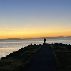
My boyfriend and I took a quick stroll on the San Andreas trail at sunset yesterday. We arrived at 430pm and since the sun comes down so much earlier nowadays, we had to cut our walk short so we wouldn't get locked in. We were out of there by 515pm. The trail is open from sunrise until sunset. You get a nice view of the San Andreas Lake on one side, but at some points, you walk alongside the 280S freeway. The trail itself is paved, so regular sneakers are just fine. It's a great trail for a walk with the fam, running, and even biking. Do note that dogs and pets are not allowed. There aren't many marked parking spots along Skyline Blvd., so you might need to make your own. We'll be back for another walk soon!

I have a soft spot for this hike. I first went on it alone a few years ago, but wasn't really too impressed. The 280 is so loud, and nearby, it frightened my oh-so-weak composition. There's also not very much shade (although some patches of nice trees which make it fragrant). Then about a month ago, I really wanted to encourage my sister to exercise and to expose my young toddler niece to the outdoors. So we went five times in two weeks. It was fantastic. My niece got to see the water, and she had so many questions about everything around her (most of which, I couldn't really give a good answer to). We were still really close to the 280, but after explaining to my niece that it was just the highway, she would just yell gleefully whenever we got close "TT! It's the 280!" Hilars, right? Can't help but to feel more cheery about being near cars driving 90 mph. Tips: No dogs allowed. No smoking. Stay on the trail (poison oak and ticks pretty much everywhere!) Be wary of cyclists, strollers. Sunny- bring a hat! For runners, there's a little bit of up and down hill that can really tire you out.

I've been on this trail a few times and it has gotten worse each time I've gone on it to exercise. There are too many tree roots poking out from the pavement makes this trail a tripping hazard to those walking, jogging and biking on this trial. Not to mention that there's a lot of negligent dog owners leaving their pets feces around the pathway. Also the pavement is consistently very uneven throughout the whole trail as there are divets, cracks, partial smooth road work done. Please fix this trail like that service road you have down near the reservoir which is smoothly paved throughout. It's very annoying looking at that smooth road while the current trail is in shambles.

Wow. Is all I can really say. Love and live in Florida - pretty much my entire life. Have pretty much seen most parts of the US. But this place is just another reminder that California is TRULY the most magnificent state in the continental 48. Easily - by far - hands down. Not even a CLOSE contest. And I say that, knowing I could NEVER afford to live here. For those that can, God bless you. You are luckiest folks alive. Because your state is truly beautiful and you are truly blessed.

1 year ago
First time I've seen a gopher snake on the trail. Excellent weather plus a little ride what more could you ask for? read more


1 year ago
Beautiful views. Nothing technical. Good for walking or biking. Great for long or short walks. read more


Even though I think this trail isn't necessarily for everyone, I really enjoyed our little visit here in a push to visit more local parks. This trail is definitely a weird mix of half urban (the freeway on one side) and half greenery and lake. If you face one side it's picturesque, if you face the other it's loud and a bit overwhelming. I'm not quite sure why they gated off the nicer trail closer to the lake, but if you can tune out the road sounds, it's very pretty here, and the paved ground and parking are a plus for me. Definitely a trail I would return to. read more


Now that I've conquered all twelve miles of the Sawyer Camp Trail along the length of Crystal Springs Reservoir, I thought I should try the northbound trail along San Andreas Lake. I simply parked at the same place, the 280 underpass at the end of Hillcrest Blvd., got out of the car, and headed right instead of left. You can tell I'm a professional hiker, can't you? Probably by the way I shrieked in a most girlish fashion at the rattlesnake warning sign that was precariously stapled onto an uncommitted barrier (photo: http://bit.ly/2Ohjtcs). Unfortunately I was all out of antivenom. Like I'd know how to use it. The first half-mile of the trail was pure gravel and weeds which made possible reptile sightings next to impossible. I found relief coming out of the semi-wilderness and following the winding pavement which afforded some lovely views of the lake (photo: http://bit.ly/2qjGIZU). My mild frustration with the trail came on either side of the trail. A wire fence provided a constant barrier to the lake visually and physically. On the other side was the cacophony of freeway traffic on 280. Regardless, it's a sturdy five-plus mile walk to and fro, but do be mindful of those rattlers. RELATED - Up for a hike? Here are the places around the Bay Area where I have trod: bit.ly/2OsCCsK read more


5 years ago
Lush Green at this time of the year !! Lake does has water and Standing on one of the Earthquake Fault Line gives goosebumps. Its very beautiful with lake on one side and lush green valley overlooking towards halfmoon bay. we did complete 6 miles sawyer camp recreation trail. Trail does goes next to 280 so it does gets noisy but perfect trail to put in your headphones and Run!! Along the trail we did see poison oak so be on lookout Parking is limited and it does get windy by the Dam so carry jackets n hoody :) read more


6 years ago
This trail starts at the intersection of San Bruno Ave and Skyline Blvd. Some people park at the lot across from Arco Storage as opposed to the uneven dirt path designated as San Andreas parking. I usually park at the 280 underpass at Larkspur. More spaces are available here as opposed to the underpass at Hillcrest. I think more people like to start at the North Trailhead of Sawyer Camp Trail and work southbound going down towards the springs. The entire distance round trip is about 5 miles from San Bruno to Hillcrest -- mostly paved, with some inclines, moderate for running, easy for walking. The recreational trail from Larkspur to Hillcrest is dirt path and forested. Sometimes people skip this part and just stick to the paved part of San Andreas and that's an easy 4 mile round trip. What I appreciate most about this trail is the bathroom accessibility. It's still a porta potty type of situation but at least you don't have to hide in the bushes when you're desperate! read more


15 years ago
San Andreas Trail is extremely functional. It has good length (running essentially from San Bruno Ave. to Crystal Springs Rd., but further linking up there with Sawyer Camp Trail), easy grading (generally flat or gently-sloped), is mostly paved, and can be accessed quickly from adjacent Skyline Blvd or I-280. It's very stroller-friendly (wide enough even for wheelchairs, actually), and is also used by walkers, joggers and bicyclists. So, utility marks are high. Beyond that, things are "perfect from afar, but far from perfect". Yes, it's next to beauty; there are two reservoirs and expansive green space running along its western edge. But the eastern edge is all-cars-all-the-time; the adjacent roadways create nearly constant traffic noise, with the corresponding vehicles frequently visible. Whether you look left or right will completely change the experience. Or, you could look up. Then, you'd spy the enormous high-voltage transmission line between the trail and the reservoirs, looming over you continuously. Even if you, unlike me, don't wonder repeatedly if your brain is being cooked remotely, it's still plenty f'ugly. And it's undeniably a utility corridor first and nature trail second; if you have any doubts, check out the chainsawed stumps and treetops along the way, presumably victims of line maintenance clearing. Again, it's a very useful trail, and I'm happy it's there, even given the occasional brush-back by an unrelenting cyclist. But I prefer things a bit more quiet and unspoiled, and there are many other accessible trails nearby that better provide both. *** Update 03/18/2011: This trail is actually in Millbrae. I've no idea why it's showing up with a Morgan Hill listing. I've already requested that error be corrected. But the position shown on the map is correct. read more


11 years ago
My boyfriend and I took a quick stroll on the San Andreas trail at sunset yesterday. We arrived at 430pm and since the sun comes down so much earlier nowadays, we had to cut our walk short so we wouldn't get locked in. We were out of there by 515pm. The trail is open from sunrise until sunset. You get a nice view of the San Andreas Lake on one side, but at some points, you walk alongside the 280S freeway. The trail itself is paved, so regular sneakers are just fine. It's a great trail for a walk with the fam, running, and even biking. Do note that dogs and pets are not allowed. There aren't many marked parking spots along Skyline Blvd., so you might need to make your own. We'll be back for another walk soon! read more

15 years ago
10 years ago
I have a soft spot for this hike. I first went on it alone a few years ago, but wasn't really too impressed. The 280 is so loud, and nearby, it frightened my oh-so-weak composition. There's also not very much shade (although some patches of nice trees which make it fragrant). Then about a month ago, I really wanted to encourage my sister to exercise and to expose my young toddler niece to the outdoors. So we went five times in two weeks. It was fantastic. My niece got to see the water, and she had so many questions about everything around her (most of which, I couldn't really give a good answer to). We were still really close to the 280, but after explaining to my niece that it was just the highway, she would just yell gleefully whenever we got close "TT! It's the 280!" Hilars, right? Can't help but to feel more cheery about being near cars driving 90 mph. Tips: No dogs allowed. No smoking. Stay on the trail (poison oak and ticks pretty much everywhere!) Be wary of cyclists, strollers. Sunny- bring a hat! For runners, there's a little bit of up and down hill that can really tire you out. read more

 otherwise my niece will forever be misinformed. - Hiking Near Me")
I've been on this trail a few times and it has gotten worse each time I've gone on it to exercise. There are too many tree roots poking out from the pavement makes this trail a tripping hazard to those walking, jogging and biking on this trial. Not to mention that there's a lot of negligent dog owners leaving their pets feces around the pathway. Also the pavement is consistently very uneven throughout the whole trail as there are divets, cracks, partial smooth road work done. Please fix this trail like that service road you have down near the reservoir which is smoothly paved throughout. It's very annoying looking at that smooth road while the current trail is in shambles. read more

9 years ago
10 years ago
Wow. Is all I can really say. Love and live in Florida - pretty much my entire life. Have pretty much seen most parts of the US. But this place is just another reminder that California is TRULY the most magnificent state in the continental 48. Easily - by far - hands down. Not even a CLOSE contest. And I say that, knowing I could NEVER afford to live here. For those that can, God bless you. You are luckiest folks alive. Because your state is truly beautiful and you are truly blessed. read more


14 years ago
14 years ago
11 years ago
Good place to run! But please let your dog stay in the car or at your house its not a dog park sign is all over no dogs allowed..... read more

More info about San Andreas Trail
San Bruno, CA 94066
Directions
Hours
Indoor Amenities
Outdoor Amenities
Ask the Community - San Andreas Trail
Review Highlights - San Andreas Trail
You might also consider


Why does Yelp recommend reviews?
1 review that is not currently recommended
The reviews below are not factored into the business's overall star rating.
10 years ago
San Andreas Trail - hiking - Updated July 2026
Best of San Bruno
People found San Andreas Trail by searching for…
Hiking Trails in San Bruno, California
Things to Do in San Bruno, California
Parks in San Bruno, California
Photo Spots in San Bruno, California
Walking Trails in San Bruno, California
Beautiful Views in San Bruno, California
Dog Friendly Hiking Trails in San Bruno, California
Watch Sunset in San Bruno, California
Sunrise View in San Bruno, California
Running Trails in San Bruno, California
Trail in San Bruno, California
View Points in San Bruno, California
Scenic View in San Bruno, California
Off Road Trails in San Bruno, California
Sunrise Hike in San Bruno, California
Free Parking in San Bruno, California
Sunset View in San Bruno, California
Sunset in San Bruno, California
Parks for Kids in San Bruno, California
Easy Hikes in San Bruno, California
Secret Spots in San Bruno, California
Fun Things to Do at Night in San Bruno, California
Trending Searches in San Bruno, CA
Black Owned Nail Salons near San Andreas Trail
Boat Rental near San Andreas Trail
Cliff Jumping near San Andreas Trail
Day Trips near San Andreas Trail
Dog Friendly Trails near San Andreas Trail
Dog Swimming near San Andreas Trail
Jet Ski Rental near San Andreas Trail
Kayak Rental near San Andreas Trail
Lakes & Ponds near San Andreas Trail
Off Road Trails near San Andreas Trail
Outdoor Activities near San Andreas Trail
Places To Walk Around near San Andreas Trail
Pool Day Pass near San Andreas Trail
Public Pools near San Andreas Trail
Public Shower near San Andreas Trail
River Swimming near San Andreas Trail
Rock Quarry near San Andreas Trail
Scenic Night View near San Andreas Trail
Scenic Overlook near San Andreas Trail
Secluded Spots near San Andreas Trail
Soccer Store near San Andreas Trail
Splash Pad near San Andreas Trail
Strawberry Picking near San Andreas Trail
Sunrise View near San Andreas Trail
Swimming Holes near San Andreas Trail
Swimming Lakes near San Andreas Trail
Watch Sunset near San Andreas Trail
Browse Articles
Browse Nearby
BEST of San Bruno, California Coffee near San Andreas Trail
BEST of San Bruno, California Restaurants near San Andreas Trail
BEST of San Bruno, California Things to Do near San Andreas Trail
BEST of San Bruno, California Walking Trails near San Andreas Trail
BEST of San Bruno, California Breakfast near San Andreas Trail
BEST of San Bruno, California Parks near San Andreas Trail
BEST of San Bruno, California Hot Springs near San Andreas Trail
BEST of San Bruno, California Campgrounds near San Andreas Trail
BEST of San Bruno, California Sightseeing near San Andreas Trail
Browse Brands
Related Searches in San Bruno, CA
Affordable Kayak Rental Services in San Bruno, California
Best Fishing Locations and Guides in San Bruno, California
Best Nature Trails for Hiking in San Bruno, California
Best Places for Horseback Riding in San Bruno, California
Best Waterfalls and Swimming Holes in San Bruno, California
Check Out Off Road Trails in San Bruno, California
Discover Dog Friendly Trails to Explore in San Bruno, California
Discover Kid Friendly Hiking Trails in San Bruno, California
Discover Scenic Hiking Trails in San Bruno, California
Discover Scenic Mountain Bike Trails Near San Bruno, California
Discover Scenic Waterfall Spots in San Bruno, California
Discover Walking Parks in San Bruno, California Near You
Discover a Hiking Trail in San Bruno, California
Discover the Best Night Hike Trails in San Bruno, California
Discover the Best Running Track in San Bruno, California
Dog-Friendly Hikes With Dogs in San Bruno, California
Enjoy Camping Adventures Around San Bruno, California
Enjoy Kayaking Adventures in San Bruno, California
Enjoy Tent Camping Spots Around San Bruno, California
Enjoy a Beautiful Waterfall Hike in San Bruno, California
Enjoy the Best Picnic Spots and Ideas in San Bruno, California
Enjoy the Best Walking Path in San Bruno, California
Enjoy the Best Walking Trails in San Bruno, California
Explore Beautiful Parks and Green Spaces in San Bruno, California
Explore Easy Hikes Perfect for All in San Bruno, California
Explore Fun Activities to Do in San Bruno, California
Explore Popular Campgrounds Near San Bruno, California
Explore the Best Beach Spots in San Bruno, California
Explore the Best Swimming Holes Around San Bruno, California
Explore the Best Trail Options in San Bruno, California
Family Friendly Hiking With Kids in San Bruno, California
Find Beautiful Views in San Bruno, California
Find the Best Parks for Picnics in San Bruno, California
Find the Best Scenic View Locations in San Bruno, California
Great Places to Walk in San Bruno, California
Hike the Popular Waterfall Trail in San Bruno, California
Hiking Trails With Waterfalls in San Bruno, California
Off Leash Dog Hiking Trails in San Bruno, California
Plan a Scenic Drive Route Near San Bruno, California
Popular Outdoor Activities to Try in San Bruno, California
Popular Picnic Spots to Visit in San Bruno, California
Safe River Swimming Areas in San Bruno, California
Safe and Fun Parks for Kids in San Bruno, California
Top Climbing Spots and Gyms in San Bruno, California
Top Paddleboarding Activities in San Bruno, California
Top Running Trails to Explore in San Bruno, California
Top Swimming Lakes to Enjoy in San Bruno, California
Top Swimming Spots and Pools in San Bruno, California
People who viewed San Andreas Trail also viewed
Sweeney Ridge
190 reviews
Sign Hill Park
60 reviews
San Bruno Mountain State & County Park
170 reviews
Milagra Ridge
70 reviews
San Pedro Valley Park
110 reviews
Mussel Rock Park
98 reviews
Seal Point Park
94 reviews
Devil's Slide Coastal Trail
145 reviews
San Bruno Mountain Watch
5 reviews
Josephine Waugh - Soroptimist Park
1 review