Cuyamaca Peak Photos


You might also consider
More like Cuyamaca Peak
Recommended Reviews - Cuyamaca Peak
Start your review...

Reviews With Photos

Beautiful hike, did the trail up to the summit in the snow and it was amazing. Trail was partially cleaned which is understandable. It was nice to experience a change of scenery in San Diego. Being from the east coast I loved it! Campground is very clean. Staff was nice. Couple cabins to rent Dress really warm wear gloves the temp drops as you het higher and it's a bit windy.

"I've been waiting, for a view like you" I thought this place was included in the National Park Adventure Pass, but sadly not. It is part of a California State Park Pass, which is much more expensive (at least 100 bucks more...) "That's gonna have to be a no from me dawg." Located almost an 1 hr east in the Descanso area, this easy hike is paved but goes straight up. The impact on your legs on the descent ruins my hiking vibe, but thats okay. 10 bucks to park in the campground area. There are restrooms at the trailhead area. Started around 8am and summited (6512 ft) in less than 2 hours. You could use trekking poles to save your legs. There is not much shade for the majority of the hike. I would start early if I were you. The landscape shows alot of dead trees from a wildfire more than a decade ago (2003.) The top was beautiful, and you can spot some wildlife and pretty flowers here. Saw a rabbit scurry around and lizards doing some sunbathing. Towards the very end, some pine trees survived the fire, and you can imagine what this place used to look like. 6 miles of hiking and about 3 hours total time out here. I am probably not going to come back for a while due to the steep parking fee. It is nice to see the plants and grass growing post fire.

Picture a beautiful mountain top with big rocks where you can sit and enjoy the fabulous view of San Diego because Cuyamaca is the second highest peak in SD at 6,512 ft... Reality: picture what looks like an abandoned radio tower with wood and trash and graffiti everywhere. We were greeted at the top with a dirty diaper (who throws a dirty diaper at the top?! Seriously people, have respect for nature) and a swarm of flies due to the dirtiness of the top. Oh yes and the smell of old stanky poop. Not what we imagined as Cuyamaca once used to be a very beautiful hike but due to the Cedar fire in 2003 that burned almost all of their big pines and oak tree left it looking scarred and bare. You can see new growth as small pine trees poke itself from the ruins. I can imagine 15 years ago it looking like a real forest and magical! What a site that would have been. The hike is all paved to the top, which makes it easy on your feet. Going up is all uphill and watch out for fire ants. We went on a hot day and it was a bad idea because the sun beats on your back. There wasn't a lot of shade until you get closer to the top. To get to the trail we went through the campsites and cut through at campsite 69 where the bathroom was located at. It took us about 3 hours and it's about a 5.6 mile hike. Since the top was so disgusting we walked about 5 minutes below the top and sat on some rocks and had a better view and smell. I wish they had some rangers to maintain the cleanliness of the hike... Or at least a trash can so disrespectful people will throw their used diapers in the trash and teenagers would stop graffitiing the place. It sucks that we had to see Cuyamaca like that. However we did love the campgrounds and booked a campsite in a few weeks and will be doing a different trail, fingers crossed that we won't see another dirty diaper!

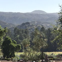
Distance round trip: ~ 6 miles Time: ~ 3 hours Difficulty: Easy. Paved trail. Constant incline. Not a lot of shade. We took the paved emergency vehicle trail up to the top of Cuyamaca Peak. It's the only trail that allows puppies, so it was kind of our only option. We parked at Paso Picacho Picnic & Campgrounds (there was a parking/park fee per vehicle, but I don't really remember how much. I was to say it was maybe $10?). It was a little difficult to find the trail head, but after wandering around for a bit and asking a few other people, we finally arrived at Camp 69 and the trail starts right about there on your left side - opposite of the restrooms. The incline isn't too steep, but it does go uphill pretty constantly. We used this hike as our first trial hike with all our gear on our backs as we are training for Mt. Whitney. Because it is all paved, we didn't have to worry too much about footing. Our main focus was to get an idea of how it felt like to go uphill with 35-40 pounds on our backs. The total trip was about 6 miles, elevation gain of about 1700 ft, and it took us about 3 hours with multiple resting stops for our pup. I killed a 3L hydration bladder easily. The views are absolutely stunning. There was a pretty significant forest fire that happened in the area a few years ago. A lot of the brush are beginning to grow back, but there's definitely still evidence of the fire all throughout the trail. It just makes the scenery hauntingly beautiful. There wasn't a whole lot of shade in May 2017. It was about 65 degrees, sunny, with a slight breeze when we started. However, when we got to the top at 6500 ft, it felt more like it was in the 50s, breezy, and quite chilly. I'm glad I had a long sleeve with me. By the time we got back down to the campsite, it felt like it was in the mid 70s. There are also tons of other side trails, but they are not dog friendly. Overall, if you're just looking for a quick day hike, I would definitely recommend Cuyamaca! I would love to come back and explore some of the other unpaved trailed. Pssst.. Bring water, snacks, and sunscreen! I also brought bug spray too just in case, but we didn't have to use it in May. Lastly, always pack out what you bring in!

New Year's Eve Snowy Hike. One of the best hiking trails in San Diego. Even though, it was snowy and about 7.7 miles loop back to the campground parking lot, the top is worth reaching. There are other ways to reach the peak, for instance a shorter uphill route about 2 miles from the campground. It is nice that this is my first time hiking on a snowy and muddy road. I saw a fox too! Definitely a must trail snowy or summer season!

One of the best hikes in the county. The views are rewarding. The trail is all paved so i feel like that makes it a bit more difficult and harder on your feet and legs. You will have to pay $10 for day use at paso picacho camp ground so might as well make a day out of it and plan a nice picnic at the Campground. Some people say this is a difficult hike but thats all depending on level of fitness i guess. There is a portable bathroom up there. No water except at campground so make sure you carry enough water. Towards the last 2 miles you walk through high pines so it makes it even more beautiful. Most of this area was all burned down in the tragic Cedar Fire in 2003. There is alot of wildlife here and mountain lion activity. If you plan to hike later in the day (dawn or night) i would carry bear spray in case of a mountain lion. Nothing to be afraid of but safety is always better. Make sure to follow @sandiegohikers on instagram!

I love this hike! Today was my 2nd visit to hike Cuyamaca peak. The 1st time I came, I had no idea where the trailhead was for this hike. I didn't even see the mountain I was hiking. I had read on the all trails app to start at Azalea Glen trail which is what I did... but it appeared to end... thought this was a loop. Idk. I was so confused. I sat on a bench looking this up online and found an article written by the hiking guy. He mentioned the trailhead was inside Paso Picacho campground next to campsite #69. So I went back the way I came in and went through the camp site areas until I found it. (Fell in love with Paso Picacho camp grounds btw....and I will camp there soon!). Anyway, I took the service road in out and back. Saw some other trails that met up to it or that I could take but I was so scared of getting lost that I just stayed on the svc road. At first there is not much shade. The wildfire from 2003 damage is quite sad. As you got up more, you were met by some gorgeous trees that made me feel like I wasn't in SoCal anymore. In my opinion, it was def a "moderate" hike. There is some construction up top but the hilltop views are around the tractor/electrical building they had. The views from over over 6k in elevation was amazing! This is the 2nd highest peak in San Diego county. Btw, there are bathrooms at trailhead and there was a port o potty at the top that's probably for the construction workers but it didn't appear to be locked . I also didn't try it though. Wear sunscreen for the non shaded areas and bring "off spray". The flys made today's hike unenjoyable because they were all over us bugging us! I did not experience this last time I came. Also, if you arrive before the ranger gets there, fill out the envelope and drop your $10 in the drop box. They will check you when you leave!

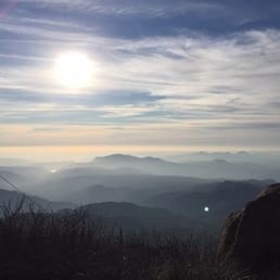
Wow. Just wow. This instantly became my favorite hike in San Diego. I wanted to get some actual elevation on a hike, so in my research I discovered Cuyamaca Peak. Though it is actually the second-highest summit in the county of San Diego, the other (Hot Springs Mountain) is on a reservation, and is not always accessible to the public. After making the drive out to the Julian/Cuyamaca area, park at the Paso Picacho Campground. There is an $8 fee at the entrance gate for day-use parking, but I'm telling you right now, it's worth it! Start the hike near campsite 69 and head up the fire access road to the top. Now, I know what you're thinking: "Walking along a fire access road? How can THIS be your favorite peak in SD?" Let me share with you the top two reasons... 1. This hike is a steady and relentless incline. Even though you are walking on hard ground or pavement most of the time, you will most certainly get a good workout. Your legs should be in prime condition when undertaking this trail. If not, they WILL be by the end of it! If you've got bad knees, or need assistance, some trekking poles would not be a bad idea. 2. The view at the top is ABSOLUTELY AMAZING. As you finally crest the summit, you'll most likely get hit by a gust of wind, and experience a bite of cold--typically unexpected in San Diego. Find yourself a high spot and take in the majestic and expansive views of the entire county. As a matter of fact, on a clear day you can see not only San Diego County, but Imperial, Riverside, San Bernardino, Orange, and Los Angeles county as well! For some added fun, bring some binoculars with you to the top. The view is out-of-this world, and is the most impressive I've seen in San Diego. Summit elevation is 6,512 feet, with an overall elevation gain of about 1,700 feet. The hike is 5.6 miles there-and-back, and is not for the faint of heart. Or leg. Expect it to take 3-4 hours of your day, even more if you spend a lot of time at the summit like I did. For a truly remarkable view, a fantastic workout, and a chance to see that it actually DOES get cold in San Diego sometimes, grab some buddies and head up this mountain. You can thank me later...
")
This is one of the best hikes i've done and as of now the hardest. We went through the Azalea Trail Loop and then passed the Azalea Springs, then the Fire road and then it felt like we've been walking forever until we reached the peak and it felt so rewarding. The azalea trail is great for pictures and it's well shaded. It was a rainy day but it comes and goes so it was ok to get wet. The Fire road i think is a shorter way to get to the peak so i would really recommend taking the Azalea trail to get a good workout. I've never imagined having blisters on my ankle but it happened thank goodness i brought my flipflops with me. The fire road is paved so if you have knee issues you better take your knee supplements and maybe wear a knee compression sleeve to help out especially walking back down.

Some friends and I hiked this trail on Saturday, June 11. The weather was in the low 70's and there was a great breeze. Having hiked this trail for over 20 years, I was really surprised, yet relieved, to see how beautiful it still looked. The result of the Cedar Creek fire is still apparent. Many trees are still charred and it appears as though cleanup is still being done on this trail. I am happy to report that the landscape has never looked greener and the new growth is abundant. This hike is a must-see; the views are amazing and the scenery is other worldly. If you desire a hike with minimal people, this is your hike. We began our hike at 9:30 AM and arrived at the top about 10:45 AM. During that time we only saw three other couples.If you desire a get-away-from-it-all hike, this is the one to do. Once you reach the top, there is a strong breeze and an amazing view! It was completely clear the day we went and we could see out into the ocean. It really does not get much better than this. If you have the opportunity to experience this hike, do it! I run about 4 miles a day, and I hike Iron Mountain in Poway twice a week without any complaints, and this hike was STILL challenging to me. It is VERY steep and there are not many flat areas. That being said, I think a person of moderate fitness could complete it if given enough time. Be prepared for a good work out and to be completely sore the next day! You will pay $8.00 to park for the day and can take your time. If you are extremely aggressive, you can go across the street and hike Stone Wall Peak; a moderate hike appropriate for the young ones. Enjoy the beauty!

This is the best hike I've been on. Also might be the longest. The views are amazing! They have a couple of trails to get to the top. We took the Azalea trail. Plenty of parking ($8). There is a great spot before you reach the top with an inspiring view and a cute bench (great for photos). There is also a camping site with cabins and picnic areas. Bathrooms are located near the entrance and further back (clean). At the top we found a box with a notebook and pencils to document our visit (some great stories in there).

Did this hike on New Years, so it was still snowy! Well not falling snow but somewhat soft snow on the ground. Starting the hike, it was dang cold. Then...we slowly had to shred our jackets. The hike is about 3 miles to the top, which is one of the highest peaks in SD. The trail is all paved, which is somewhat of a downside for me, but it's the fire road, so understandable. You can see all around the results of the cedar fire that destroyed so much of the area. Careful where you step, there are so much dog poops throughout the trail. The view on top was beautiful. On a clear day, you can see most of San Diego and the border.

Really enjoyed this trail. Parked at the Paso campground for $8 and cut through the campground to get to the fire road. Incline the whole way. About 1 mile up was snow. Toward the top was windy/cold so bring a sweatshirt! Dynamic hike the whole way. Lush for the last 1/2 mile. Great views on top! Good hike all around. Took about 3hrs for 6 miles.
This review is for the Cuyamaca Peak Via Azalea Glen Loop which was a ~7.7 mile round trip that took ~4 hours to complete. There was a $10 day use fee. The views for the first half were mostly blocked by tall shrubs or trees. There were nice views of Lake Cuyamaca at higher elevation. The second half was a descent on paved road. Trail starts and ends at the campground. Furthermore, there were a lot of flies. Trail starts off flat, becomes a steady incline and eventually a steeper incline. In addition, it was around 25% shaded otherwise mostly exposed to the sun. Short video of the hike for those interested! https://youtu.be/7pV1e1tji1U read more


5 years ago
I finally had the chance and energy to hike Cuyamaca Peak. It is paved to the top. For some it could be a good or bad thing. I could only imagine the black top would radiate the heat during the summer. For my hike with my friends the weather was perfect. It was warm but the nice breeze kept us cool and trees provided shade it made it comfortable for most of the hike. We hiked CP the 2nd weekend of October. Our hike began at 10ish, the trail started on the south east side of the camp, not far from out campsites (17, 18 and 19). Thereare plenty of native plants to see and of course many views perfect for some pictures. I felt the elevation was gradual until the last half mile. The area had rain a few weeks prior, the evidence left on the path that flowed in from the sides. Loose sand and gravel did cover some areas something to watch for especially coming down the peak. Nearing the middle of the hike you will notice the large pine trees that will have these beautiful, large pine cones. I think my friends said they are called, Widow Makers. The sides of the path are scattered with the pine trees decor. There were evidence of fire in spots too. We weren't sure if this was a controlled fire or not. You will find Stonewall Peak across from you become smaller as your reach the top of CP. On your way up don't forget to check everything around you! Also, stop to check out Cuyamaca Lake. At the top, soak in the views! I could almost see the ocean, a light haze makes its presence. It was definitely worth the hike up to CP. read more


We did this hike on Saturday (1/13/18) and really enjoyed it. Parking- you park in the area of a campground along CA-79 and it is the same lot used if you are doing the Stonewall Peak hike which starts on the other side of the highway; you must pay $10 and if you get there early like we did before a Park Ranger is on duty you must fill out an envelope and drop the $/envelope in a slot so make sure you have exact cash; no special Adventure Day Pass is needed Trail/route- we did the loop starting w/Azalea Glen to the Azalea Springs Fire Road to Conejos Trail which at about 4.2 miles will take you to a paved fire road...make sure to turn right at this juncture and this will be the hardest steepest part of the hike for the final 1/2 mile to the top and you will have completed approx. 4.8 miles to get to the top; we took the paved fire road straight down to complete the loop and it will total about 7.5 miles when you get back to the parking lot and it takes around 4 hrs to complete starting at about 4,900 ft and reaching the top at nearly 6,500 ft My thoughts: this is a beautiful area and the drive to the trailhead offers so much to see; it is not a crowded trail; there are great views of Cuayamaca Lake and the hills to the east and when you get to the top you are rewarded with a great view looking west to San Diego and the Pacific on a clear day; most of the hike is easy especially the first 2 miles of the loop if you go counter clockwise like we did and the only difficult part was the last 1/2 mile going up the steep fire road to the top read more

Beautiful hike, did the trail up to the summit in the snow and it was amazing. Trail was partially cleaned which is understandable. It was nice to experience a change of scenery in San Diego. Being from the east coast I loved it! Campground is very clean. Staff was nice. Couple cabins to rent Dress really warm wear gloves the temp drops as you het higher and it's a bit windy. read more


7 years ago
"I've been waiting, for a view like you" I thought this place was included in the National Park Adventure Pass, but sadly not. It is part of a California State Park Pass, which is much more expensive (at least 100 bucks more...) "That's gonna have to be a no from me dawg." Located almost an 1 hr east in the Descanso area, this easy hike is paved but goes straight up. The impact on your legs on the descent ruins my hiking vibe, but thats okay. 10 bucks to park in the campground area. There are restrooms at the trailhead area. Started around 8am and summited (6512 ft) in less than 2 hours. You could use trekking poles to save your legs. There is not much shade for the majority of the hike. I would start early if I were you. The landscape shows alot of dead trees from a wildfire more than a decade ago (2003.) The top was beautiful, and you can spot some wildlife and pretty flowers here. Saw a rabbit scurry around and lizards doing some sunbathing. Towards the very end, some pine trees survived the fire, and you can imagine what this place used to look like. 6 miles of hiking and about 3 hours total time out here. I am probably not going to come back for a while due to the steep parking fee. It is nice to see the plants and grass growing post fire. read more


Picture a beautiful mountain top with big rocks where you can sit and enjoy the fabulous view of San Diego because Cuyamaca is the second highest peak in SD at 6,512 ft... Reality: picture what looks like an abandoned radio tower with wood and trash and graffiti everywhere. We were greeted at the top with a dirty diaper (who throws a dirty diaper at the top?! Seriously people, have respect for nature) and a swarm of flies due to the dirtiness of the top. Oh yes and the smell of old stanky poop. Not what we imagined as Cuyamaca once used to be a very beautiful hike but due to the Cedar fire in 2003 that burned almost all of their big pines and oak tree left it looking scarred and bare. You can see new growth as small pine trees poke itself from the ruins. I can imagine 15 years ago it looking like a real forest and magical! What a site that would have been. The hike is all paved to the top, which makes it easy on your feet. Going up is all uphill and watch out for fire ants. We went on a hot day and it was a bad idea because the sun beats on your back. There wasn't a lot of shade until you get closer to the top. To get to the trail we went through the campsites and cut through at campsite 69 where the bathroom was located at. It took us about 3 hours and it's about a 5.6 mile hike. Since the top was so disgusting we walked about 5 minutes below the top and sat on some rocks and had a better view and smell. I wish they had some rangers to maintain the cleanliness of the hike... Or at least a trash can so disrespectful people will throw their used diapers in the trash and teenagers would stop graffitiing the place. It sucks that we had to see Cuyamaca like that. However we did love the campgrounds and booked a campsite in a few weeks and will be doing a different trail, fingers crossed that we won't see another dirty diaper! read more


9 years ago
Distance round trip: ~ 6 miles Time: ~ 3 hours Difficulty: Easy. Paved trail. Constant incline. Not a lot of shade. We took the paved emergency vehicle trail up to the top of Cuyamaca Peak. It's the only trail that allows puppies, so it was kind of our only option. We parked at Paso Picacho Picnic & Campgrounds (there was a parking/park fee per vehicle, but I don't really remember how much. I was to say it was maybe $10?). It was a little difficult to find the trail head, but after wandering around for a bit and asking a few other people, we finally arrived at Camp 69 and the trail starts right about there on your left side - opposite of the restrooms. The incline isn't too steep, but it does go uphill pretty constantly. We used this hike as our first trial hike with all our gear on our backs as we are training for Mt. Whitney. Because it is all paved, we didn't have to worry too much about footing. Our main focus was to get an idea of how it felt like to go uphill with 35-40 pounds on our backs. The total trip was about 6 miles, elevation gain of about 1700 ft, and it took us about 3 hours with multiple resting stops for our pup. I killed a 3L hydration bladder easily. The views are absolutely stunning. There was a pretty significant forest fire that happened in the area a few years ago. A lot of the brush are beginning to grow back, but there's definitely still evidence of the fire all throughout the trail. It just makes the scenery hauntingly beautiful. There wasn't a whole lot of shade in May 2017. It was about 65 degrees, sunny, with a slight breeze when we started. However, when we got to the top at 6500 ft, it felt more like it was in the 50s, breezy, and quite chilly. I'm glad I had a long sleeve with me. By the time we got back down to the campsite, it felt like it was in the mid 70s. There are also tons of other side trails, but they are not dog friendly. Overall, if you're just looking for a quick day hike, I would definitely recommend Cuyamaca! I would love to come back and explore some of the other unpaved trailed. Pssst.. Bring water, snacks, and sunscreen! I also brought bug spray too just in case, but we didn't have to use it in May. Lastly, always pack out what you bring in! read more


New Year's Eve Snowy Hike. One of the best hiking trails in San Diego. Even though, it was snowy and about 7.7 miles loop back to the campground parking lot, the top is worth reaching. There are other ways to reach the peak, for instance a shorter uphill route about 2 miles from the campground. It is nice that this is my first time hiking on a snowy and muddy road. I saw a fox too! Definitely a must trail snowy or summer season! read more


One of the best hikes in the county. The views are rewarding. The trail is all paved so i feel like that makes it a bit more difficult and harder on your feet and legs. You will have to pay $10 for day use at paso picacho camp ground so might as well make a day out of it and plan a nice picnic at the Campground. Some people say this is a difficult hike but thats all depending on level of fitness i guess. There is a portable bathroom up there. No water except at campground so make sure you carry enough water. Towards the last 2 miles you walk through high pines so it makes it even more beautiful. Most of this area was all burned down in the tragic Cedar Fire in 2003. There is alot of wildlife here and mountain lion activity. If you plan to hike later in the day (dawn or night) i would carry bear spray in case of a mountain lion. Nothing to be afraid of but safety is always better. Make sure to follow @sandiegohikers on instagram! read more


8 years ago
I love this hike! Today was my 2nd visit to hike Cuyamaca peak. The 1st time I came, I had no idea where the trailhead was for this hike. I didn't even see the mountain I was hiking. I had read on the all trails app to start at Azalea Glen trail which is what I did... but it appeared to end... thought this was a loop. Idk. I was so confused. I sat on a bench looking this up online and found an article written by the hiking guy. He mentioned the trailhead was inside Paso Picacho campground next to campsite #69. So I went back the way I came in and went through the camp site areas until I found it. (Fell in love with Paso Picacho camp grounds btw....and I will camp there soon!). Anyway, I took the service road in out and back. Saw some other trails that met up to it or that I could take but I was so scared of getting lost that I just stayed on the svc road. At first there is not much shade. The wildfire from 2003 damage is quite sad. As you got up more, you were met by some gorgeous trees that made me feel like I wasn't in SoCal anymore. In my opinion, it was def a "moderate" hike. There is some construction up top but the hilltop views are around the tractor/electrical building they had. The views from over over 6k in elevation was amazing! This is the 2nd highest peak in San Diego county. Btw, there are bathrooms at trailhead and there was a port o potty at the top that's probably for the construction workers but it didn't appear to be locked . I also didn't try it though. Wear sunscreen for the non shaded areas and bring "off spray". The flys made today's hike unenjoyable because they were all over us bugging us! I did not experience this last time I came. Also, if you arrive before the ranger gets there, fill out the envelope and drop your $10 in the drop box. They will check you when you leave! read more


12 years ago
Wow. Just wow. This instantly became my favorite hike in San Diego. I wanted to get some actual elevation on a hike, so in my research I discovered Cuyamaca Peak. Though it is actually the second-highest summit in the county of San Diego, the other (Hot Springs Mountain) is on a reservation, and is not always accessible to the public. After making the drive out to the Julian/Cuyamaca area, park at the Paso Picacho Campground. There is an $8 fee at the entrance gate for day-use parking, but I'm telling you right now, it's worth it! Start the hike near campsite 69 and head up the fire access road to the top. Now, I know what you're thinking: "Walking along a fire access road? How can THIS be your favorite peak in SD?" Let me share with you the top two reasons... 1. This hike is a steady and relentless incline. Even though you are walking on hard ground or pavement most of the time, you will most certainly get a good workout. Your legs should be in prime condition when undertaking this trail. If not, they WILL be by the end of it! If you've got bad knees, or need assistance, some trekking poles would not be a bad idea. 2. The view at the top is ABSOLUTELY AMAZING. As you finally crest the summit, you'll most likely get hit by a gust of wind, and experience a bite of cold--typically unexpected in San Diego. Find yourself a high spot and take in the majestic and expansive views of the entire county. As a matter of fact, on a clear day you can see not only San Diego County, but Imperial, Riverside, San Bernardino, Orange, and Los Angeles county as well! For some added fun, bring some binoculars with you to the top. The view is out-of-this world, and is the most impressive I've seen in San Diego. Summit elevation is 6,512 feet, with an overall elevation gain of about 1,700 feet. The hike is 5.6 miles there-and-back, and is not for the faint of heart. Or leg. Expect it to take 3-4 hours of your day, even more if you spend a lot of time at the summit like I did. For a truly remarkable view, a fantastic workout, and a chance to see that it actually DOES get cold in San Diego sometimes, grab some buddies and head up this mountain. You can thank me later... read more


11 years ago
5 years ago
This is one of the best hikes i've done and as of now the hardest. We went through the Azalea Trail Loop and then passed the Azalea Springs, then the Fire road and then it felt like we've been walking forever until we reached the peak and it felt so rewarding. The azalea trail is great for pictures and it's well shaded. It was a rainy day but it comes and goes so it was ok to get wet. The Fire road i think is a shorter way to get to the peak so i would really recommend taking the Azalea trail to get a good workout. I've never imagined having blisters on my ankle but it happened thank goodness i brought my flipflops with me. The fire road is paved so if you have knee issues you better take your knee supplements and maybe wear a knee compression sleeve to help out especially walking back down. read more
 - Hiking Near Me - Descanso, California")


15 years ago
Some friends and I hiked this trail on Saturday, June 11. The weather was in the low 70's and there was a great breeze. Having hiked this trail for over 20 years, I was really surprised, yet relieved, to see how beautiful it still looked. The result of the Cedar Creek fire is still apparent. Many trees are still charred and it appears as though cleanup is still being done on this trail. I am happy to report that the landscape has never looked greener and the new growth is abundant. This hike is a must-see; the views are amazing and the scenery is other worldly. If you desire a hike with minimal people, this is your hike. We began our hike at 9:30 AM and arrived at the top about 10:45 AM. During that time we only saw three other couples.If you desire a get-away-from-it-all hike, this is the one to do. Once you reach the top, there is a strong breeze and an amazing view! It was completely clear the day we went and we could see out into the ocean. It really does not get much better than this. If you have the opportunity to experience this hike, do it! I run about 4 miles a day, and I hike Iron Mountain in Poway twice a week without any complaints, and this hike was STILL challenging to me. It is VERY steep and there are not many flat areas. That being said, I think a person of moderate fitness could complete it if given enough time. Be prepared for a good work out and to be completely sore the next day! You will pay $8.00 to park for the day and can take your time. If you are extremely aggressive, you can go across the street and hike Stone Wall Peak; a moderate hike appropriate for the young ones. Enjoy the beauty! read more


10 years ago
This is the best hike I've been on. Also might be the longest. The views are amazing! They have a couple of trails to get to the top. We took the Azalea trail. Plenty of parking ($8). There is a great spot before you reach the top with an inspiring view and a cute bench (great for photos). There is also a camping site with cabins and picnic areas. Bathrooms are located near the entrance and further back (clean). At the top we found a box with a notebook and pencils to document our visit (some great stories in there). read more

Did this hike on New Years, so it was still snowy! Well not falling snow but somewhat soft snow on the ground. Starting the hike, it was dang cold. Then...we slowly had to shred our jackets. The hike is about 3 miles to the top, which is one of the highest peaks in SD. The trail is all paved, which is somewhat of a downside for me, but it's the fire road, so understandable. You can see all around the results of the cedar fire that destroyed so much of the area. Careful where you step, there are so much dog poops throughout the trail. The view on top was beautiful. On a clear day, you can see most of San Diego and the border. read more


15 years ago
Really enjoyed this trail. Parked at the Paso campground for $8 and cut through the campground to get to the fire road. Incline the whole way. About 1 mile up was snow. Toward the top was windy/cold so bring a sweatshirt! Dynamic hike the whole way. Lush for the last 1/2 mile. Great views on top! Good hike all around. Took about 3hrs for 6 miles. read more


10 years ago
It's 3 miles of brutal incline. There is no flat area on the trail. No shade on first 2.5 miles. On the top views are nice and nice shaded areas with tall trees. Make sure you ask rangers clearly where is the trail head. It's not clearly marked and rangers don't seem to make that extra effort to tell you directions. If you want some real work out I recommend this trail but I won't be going back anytime soon. So total length of trail is close to 6 miles. read more


12 years ago
13 years ago
11 years ago
13 years ago
11 years ago
About an hour and a half drive from San Diego, we arrived at the Paso Picacho camp ground at around 10am December 12, 2015. We paid the $8 day pass and got a trail map to start our hike. Since it was still cold that morning, the fire road from the parking lot was still pretty icy. We decided to take the Azalea Glen trail loop which took us to the right instead of going left onto the fire road. The trail was a mix of ice, snow and mud. The trees and surrounding was beautiful, and I would recommend the loop. We eventually made it to the Azalea Springs which connected us to the fire road. We took the fire road the rest of the way up. We stopped at a lookout which posed the most beautiful trees with hanging icicles. After almost being knocked off the mountain by the wind, we continued our way up the peak. At the top, we were greeted by strong winds and a beautiful view. The way down was a little tricky since it was icy and there was patches of black ice. Overall, it was a beautiful chilly and windy day. I wore long leggings with wool socks, a long sleeve, fleece, best, beanie and gloves and I was pretty good. There were only a few times where I was very happy for my gloves and where it was really chilly. Overall, be prepared for ice at this time and high winds. read more


14 years ago
11 years ago
More info about Cuyamaca Peak
Ask the Community - Cuyamaca Peak
Review Highlights - Cuyamaca Peak
You might also consider


Cuyamaca Peak - hiking - Updated July 2026
Best of Descanso
People found Cuyamaca Peak by searching for…
Natural Hot Springs in Descanso, California
Campgrounds in Descanso, California
Dinosaur Park in Descanso, California
Fireworks in Descanso, California
Dog Friendly Hiking Trails in Descanso, California
Forest in Descanso, California
River Swimming in Descanso, California
National Parks in Descanso, California
Lookout Points in Descanso, California
Public Shower in Descanso, California
Redwood Trees in Descanso, California
Hiking Trails in Descanso, California
Easy Hikes in Descanso, California
Snow Park in Descanso, California
Things to Do in Descanso, California
Sand Dunes in Descanso, California
Shaded Hike in Descanso, California
Sunbathing in Descanso, California
Sunset View in Descanso, California
Waterfall Hike in Descanso, California
Hiking Club in Descanso, California
Scenic View in Descanso, California
Trending Searches in Descanso, CA
4th Of July Fireworks in Descanso, CA
Black Owned Nail Salons in Descanso, CA
Dog Friendly Beaches in Descanso, CA
Free Picnic Areas in Descanso, CA
Jet Ski Rental in Descanso, CA
Kids Activities Outdoor in Descanso, CA
Off Road Trails in Descanso, CA
Outdoor Activities in Descanso, CA
Outdoor Basketball Courts in Descanso, CA
Places To Walk Around in Descanso, CA
Public Beaches in Descanso, CA
River Swimming in Descanso, CA
Running Trails in Descanso, CA
Scenic Night View in Descanso, CA
Scenic Overlook in Descanso, CA
Secluded Spots in Descanso, CA
Strawberry Picking in Descanso, CA
Swimming Holes in Descanso, CA
Swimming Lakes in Descanso, CA
Things To Do With Kids in Descanso, CA
Browse Nearby
BEST of Descanso, California Restaurants near Cuyamaca Peak
BEST of Descanso, California Coffee near Cuyamaca Peak
BEST of Descanso, California Lakes near Cuyamaca Peak
BEST of Descanso, California Things to Do near Cuyamaca Peak
BEST of Descanso, California Beaches near Cuyamaca Peak
BEST of Descanso, California Hot Springs near Cuyamaca Peak
BEST of Descanso, California Breakfast near Cuyamaca Peak
Browse Brands
Related Searches in Descanso, CA
Best Fishing Locations and Guides in Descanso, California
Best Off Leash Dog Parks in Descanso, California
Best Parks for Parties and Events in Descanso, California
Best Places for Horseback Riding in Descanso, California
Best Places for Stunning Views in Descanso, California
Best Water Parks for Kids in Descanso, California
Best Waterfalls and Swimming Holes in Descanso, California
Check Out Great Playgrounds in Descanso, California
Check Out Off Road Trails in Descanso, California
Discover Baseball Fields Around Descanso, California
Discover Beautiful Garden Spots in Descanso, California
Discover Fun Toddler Parks in Descanso, California for Your Little One
Discover Lakes & Ponds to Explore in Descanso, California
Discover Popular Photo Spots in Descanso, California
Discover Scenic Bike Paths in Descanso, California
Discover Scenic Hiking Trails in Descanso, California
Discover Scenic Mountain Bike Trails Near Descanso, California
Discover Soccer Fields in Descanso, California Near You
Discover Top Nature Parks to Visit in Descanso, California
Discover Top State Parks to Visit in Descanso, California
Discover Walking Parks in Descanso, California Near You
Discover a Hiking Trail in Descanso, California
Discover the Best Kids Park Spots in Descanso, California
Discover the Best Night Hike Trails in Descanso, California
Discover the Best Running Track in Descanso, California
Dog-Friendly Hikes With Dogs in Descanso, California
Effective Stairs Workout Spots in Descanso, California
Enjoy Kayaking Adventures in Descanso, California
Enjoy Scenic Places to Walk in Descanso, California
Enjoy a Beautiful Waterfall Hike in Descanso, California
Enjoy the Best Picnic Spots and Ideas in Descanso, California
Enjoy the Best Tubing Experiences in Descanso, California
Enjoy the Best Walking Path in Descanso, California
Enjoy the Best Walking Trails in Descanso, California
Exciting Cliff Jumping Spots in Descanso, California
Experience Thrilling White Water Rafting in Descanso, California
Explore Beautiful Parks and Green Spaces in Descanso, California
Explore Easy Hikes Perfect for All in Descanso, California
Explore Family-Friendly Zoos and Wildlife in Descanso, California
Explore Free Picnic Areas Around Descanso, California
Explore Outdoor Basketball Courts for All Skill Levels in Descanso, California
Explore Parks With Pull Up Bars in Descanso, California
Explore Popular Campgrounds Near Descanso, California
Explore Popular RV Parks Around Descanso, California
Explore Popular Scenic Overlook Points in Descanso, California
Explore Scenic Lakes to Visit in Descanso, California
Explore Top Dog Parks in Descanso, California Near You
Explore the Best Beach Spots in Descanso, California
Browse Articles
People who viewed Cuyamaca Peak also viewed
Cedar Creek Falls
358 reviews
Volcan Mountain Preserve
87 reviews
Oak Canyon Trail
25 reviews
Three Sisters Falls
369 reviews
Cowles Mountain
1031 reviews
Santa Ysabel Open Space Preserve West
13 reviews
Historic Flume Trailhead
2 reviews
Blossom Valley
Cuyamaca Rancho State Park
68 reviews
Hike Garnet Peak via PCT
2 reviews
Ramona Oaks Shade Trail
1 review