Iron Mountain Photos


You might also consider
More like Iron Mountain
Recommended Reviews - Iron Mountain
Start your review...

Reviews With Photos

I visited on a Sunday morning around 10:30 AM. The parking lot was full, and many people were parking along the highway. There were lots of hikers, many with their dogs. The trail is 5.7 miles long. I brought a dog along, and we finished in just under two hours. The hike up has plenty of rocks, but not many loose ones, so slipping wasn't much of a concern. The views were beautiful, and overall, the hike wasn't too strenuous. There are bathrooms located at the trailhead, and a short way into the hike, there are picnic tables where people can stop for lunch.

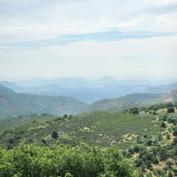
The Iron Mountain hiking trail in Poway is good for both beginners and intermediate hikers. The trail extends just over 5 miles round trip, with manageable uphill routes. There were plenty of friendly hikers in the vicinity. Towards the midway section of the trail, you will find a refreshing stream. As you go on a higher plane, you will see stunning vistas of open fields, plenty of trees and a clear skyline.

Iron Mountain is located in Poway, and it offers many trails to hike, run, or just to sit back and enjoy nature away from the bustling city. We came here early in the morning to get a quick break from the city and just to sit back and enjoy the beautiful mountains and trails that this place has. The parking here is on a gravel rock parking lot that has ample parking and can be easily accessed from the street. The entrance is covered in an abundance of trees and shade as you walk up to Iron Mountain. The trails are easily identified by the dirt pavement on the ground. Please be prepared to bring canteens of water and ice since there are no water stations on site, and during the summer months, it can get hot. There are many signs throughout the trail reminding you of rattlesnakes. Through our hike, we saw many lizards and butterflies and heard notices we would have never heard in the city. There are a couple of lakes here, and we even saw a sign for night fishing. There is a restroom in the parking lot, and when we we left, we decided to skip it and wait until we got home since it definitely needed attention. Overall, it was a great place to go to and enjoy nature at its finest. I highly recommend coming in the early fall or spring and early in the summer months to avoid the heat since it can get pretty hot and, as always, hydrate, hydrate, and hydrate!


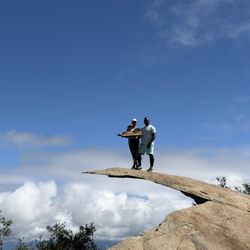
IRON MOUNTAIN-HIKERS WANTED The entire trail is wondrous with panoramic vistas of rolling hills, distant mountains, and boulder formations. One of the highlights of the hike was the tree arch entry that greets you with blessings for a good hike. And that's about all the shade you will get :). AMENITIES The portopotties are a sanitary mayhem and need to be closed for hazmat. The stench reaches the parking lot. Parking & trail are free. HOW FIT DO YOU HAVE TO BE FOR THIS HIKE? If you do cardio at least 4 hours weekly, you can manage this hike. But I also saw: A woman with flip flops A man carrying two 3 gallon jugs filled with water All age ranges and weight classes A first timer hiker and the list goes on. WHAT WAS YOUR OVERALL EXPERIENCE? I experienced the hike to be fun and interesting with the different terrain, views, switchbacks and boulders. If you can step up on a curb or do lunges then you can step on, over, or to the side of the boulders. With that being said, there are walking crevasses next to the boulders on the trail. I heard the hike was hard and because of my success on Saturday. I thought it was a fluke, so I went back the following next day. And it was just as enjoyable. Overall, this 5.8 mile hike offered a mix of natural beauty, conditioning, and satisfaction. It's a great way to connect with friends, groups, nature and obviously movement. I highly recommend Iron Mountain instead of Cowles mountain. HIGHLIGHTS Well maintained and clearly marked Perfect for new solo hikers No dog or human feces on trail NEED TO KNOW Can be done with/out trekking poles. I take mine because dogs were not leashed, although required San Diego temps can still reach the 80's in October. "A mustard seed of faith can move mountains. Have a mountainous faith to move every obstacle in your path." --Juken #JUKEN123 #ironmountainsd #hikepowaysd #hikepanoramicviews

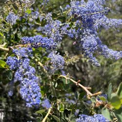
Do it! Gorgeous trail that has a nice combo of flat-ish and incline paths. We came for a sunrise hike and were not disappointed. Right now in late March all of the California Lilac were in full bloom and it gave new meaning to that like "purple mountain majesty". Took us about 3.5 hours because we lingered at the summit. There were sweet little streams and trickles of water that made the experience even better as we hiked to the sound of running water here and there. It was a partly cloudy morning so the sun was kinder than summer months, enough pockets of shade to hide behind from large boulders. Hoping to be back with my 8 year old who is new to hiking but could most likely do this trail with no sweat as the path is well maintained and not too difficult IMO. Happy hiking y'all!


***This Review Is About Hiking To See the Sunrise!*** As you can see from my pics, the views are STUNNING when you come here for the sunrise. You'll see lots of clouds floating in the air and beautiful mountain views (of course). Photos don't even do it justice. You feel like you're higher than you really are! Even Mt. Soledad is barely peeking through the clouds. It looked like a little island in the sky. So cool. TRAIL LENGTH: -5 to 6 miles (My phone always says this hike is closer to 6, despite most sites saying it is closer to 5 miles, fyi) TRAIL TERRAIN: -Mostly dirt & lots of rocks. Not quite a simple hiking path like Potato Chip or Penasquitos. I found this hike more challenging for this reason. You can't zone out as much because you have to watch where you're going/stepping. Though I've seen experienced runners sprint up and down this trail, I would not recommend it. TIPS FOR A SUNRISE HIKE: - Start about 1 hr before that morning's sunrise, or start 1.5 hrs early if you think it will take you awhile to get up there. - Pack lots of water/electrolyte drinks. I like to bring 2 bottles of water/Gatorade personally. - In the summer months, I usually start around 5am because it takes about 1 hr for me to get up to the summit. I run hot so I just wear leggings & a tank top. Temp is in the 60s when I start. - I've done this hike at sunrise a few times in July. It's not dark enough to the point where you need a flashlight. - Optional: bring a snack to eat at the summit to reward yourself as you take in the view. There are 2 picnic tables! DOG OWNERS: -I love hiking with my dog too, but PLEASE look after your dog. Keep your dog leashed (even if they have perfect recall) for the safety of others. Also be aware some dogs/humans are not comfortable with dogs walking/running towards them. -Clean up after your dog. So so so many irresponsible owners do not pick up after their dog, and it's just disgusting. I have a dog too, but please respect the trail and other hikers. I know it sucks to hold onto it for so many miles (there's only 1 trash can & it's at the entrance), but be mindful of others. OTHER COMMENTS: -The terrain is DIRT & ROCKS. You will literally have to climb/walk on actual rocks. It is very easy to slip and fall or twist your ankle so please be careful. I've seen people run up and down this trail, but that is something I personally would not do. -I've done the hike in regular running shoes (HOKAs) and had no issue. However, be aware your shoes/socks will have a layer of dirt on them by the end, so don't wear your favorite white shoes. -There is almost NO SHADE on this trail, so in the warmer months, I recommend doing it closer to sunset or before the sun rises. PARKING: -Parking is free for everyone! On weekends, if you are here around 8am, the parking lot will already be at 75-85% capacity, just fyi. There is extra parking on the road though. RESTROOMS: -There are restrooms located in the parking lot & none others on the entire trail. As of July 2021, I know that they're open to the public. (I believe they had closed temporarily due to the pandemic last year.)

Great 6 mile workout for my soul. Came during a weekday, bright and early to avoid the crowds. Decent parking , but nasty bathrooms at the start of the trail. Thankfully I'm always prepared and brought everything from wipes, toilet seat covers, spray and hand sanitizer!! Haha! But use them before you start because it's a long hike and there are no restrooms on the path. Don't get to comfortable with the shaded archway leading onto the trail because that is the only shade you get. I highly recommend lots of water and sunscreen with a good pair of hiking boots. The trail can be steep and rocky at times. The view at the top makes it all worth it! Great hike to clear your mind and a great workout for the soul.


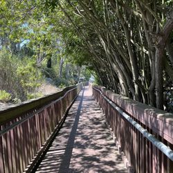
We're slowly getting back into our hiking groove, carefully navigating a post-pandemic great outdoors. This was our first time hiking Iron Mountain, and we're now fans of this spot. The beautiful and welcoming tree tunnel really sets the mood, welcoming you in before opening up to the trails. And goodness, that tree tunnel is absolutely a blessing on your way back to the parking lot, offering respite from the sun, dropping the temperature by a good 10 degrees. We arrived a bit later than planned, as our morning started with a lot more lazing-in-bed than prepping-to-hike, but it worked out, because we were able to find parking in the dirt lot. We set out at around 11:30 am, which isn't smart on most days, but this particular Saturday in April was cool and a bit overcast, which helped a ton. There's a lot of good signage along the trails, which helps those who get lost easily...or frequently. It was also nice to see that the rescue team was on hand, buzzing the trails in the bright yellow helicopter, keeping an eye out for anyone in distress. The trails did get a bit tight - it's a popular spot - but for the most part, people were respectful and tried to keep as much distance as possible. There were a fair number of mask-less hikers out, but that's not the trail's fault. You get those people everywhere. We didn't spend as much time at the top as I would've liked - it was quite packed up there and we could see more people making their way to the summit, but it is quite pretty there. We were at least able to catch our breath and take a few pictures before making our way back down. I imagine we'll be heading back to Iron Mountain for another hike later this year, but we're also eager to explore some of our city's other trails, first. I am glad that we smothered ourselves in sunblock and had 64 ounces of water on us. There's not much shade on those open dirt trails.

Just down the road from Mount Woodson, Iron Mountain is a pretty easy hike. About 6 miles round trip. Get to the parking lot early, as it gets filled up by 7am, but plenty of street parking. Hike is moderate in elevation gain. The view at the top is okay, you can see the mountains and on a very very clear day you can kind of see San Diego. Lots of rocks that you can sit and relax and enjoy the fresh air. During COVID SIP this hike is super busy because Cowles Mountain closed. If you live in San Diego you got to do this hike.

I've done this trail a few times now. On my most recent visit, I picked a cloudy day in May since there's basically no shade on the entire trail. I started around 7:30am, and there were already a lot of people heading back down, probably people who came earlier to catch the sunrise. The trail itself is easy to moderate, well marked, and has really nice views both on the way up and on the way back down. Lots of parking in a big lot. read more


8 months ago
Amazing beautiful hike! Second time hiking this but it's been years. Was a beautiful day and such excellent fresh air and scenery. Everyone on the trail was friendly and courteous. Took about 2.5 hours! Feel great! Parking was good and even though it is a holiday, not too crowded. Very clean trail even though many people had dogs with them! Definitely a hike I'll do again! read more


Iron Mountain Trails is a great moderate hike and an excellent workout if you want to break a sweat. I highly recommend going early, bringing plenty of water, and packing a snack to enjoy when you get to the summit. It's pet-friendly and a great option for anyone looking for a solid outdoor workout. Be sure to wear proper hiking attire and check the weather before you go. read more


7 months ago
1 year ago
I visited on a Sunday morning around 10:30 AM. The parking lot was full, and many people were parking along the highway. There were lots of hikers, many with their dogs. The trail is 5.7 miles long. I brought a dog along, and we finished in just under two hours. The hike up has plenty of rocks, but not many loose ones, so slipping wasn't much of a concern. The views were beautiful, and overall, the hike wasn't too strenuous. There are bathrooms located at the trailhead, and a short way into the hike, there are picnic tables where people can stop for lunch. read more


11 months ago
The Iron Mountain hiking trail in Poway is good for both beginners and intermediate hikers. The trail extends just over 5 miles round trip, with manageable uphill routes. There were plenty of friendly hikers in the vicinity. Towards the midway section of the trail, you will find a refreshing stream. As you go on a higher plane, you will see stunning vistas of open fields, plenty of trees and a clear skyline. read more


Iron Mountain is located in Poway, and it offers many trails to hike, run, or just to sit back and enjoy nature away from the bustling city. We came here early in the morning to get a quick break from the city and just to sit back and enjoy the beautiful mountains and trails that this place has. The parking here is on a gravel rock parking lot that has ample parking and can be easily accessed from the street. The entrance is covered in an abundance of trees and shade as you walk up to Iron Mountain. The trails are easily identified by the dirt pavement on the ground. Please be prepared to bring canteens of water and ice since there are no water stations on site, and during the summer months, it can get hot. There are many signs throughout the trail reminding you of rattlesnakes. Through our hike, we saw many lizards and butterflies and heard notices we would have never heard in the city. There are a couple of lakes here, and we even saw a sign for night fishing. There is a restroom in the parking lot, and when we we left, we decided to skip it and wait until we got home since it definitely needed attention. Overall, it was a great place to go to and enjoy nature at its finest. I highly recommend coming in the early fall or spring and early in the summer months to avoid the heat since it can get pretty hot and, as always, hydrate, hydrate, and hydrate! read more

1 year ago
They have toilets, trash, dog bags, and a parking lot. The trees on the pathway are pretty. The rest of the trail is very open air. read more


IRON MOUNTAIN-HIKERS WANTED The entire trail is wondrous with panoramic vistas of rolling hills, distant mountains, and boulder formations. One of the highlights of the hike was the tree arch entry that greets you with blessings for a good hike. And that's about all the shade you will get :). AMENITIES The portopotties are a sanitary mayhem and need to be closed for hazmat. The stench reaches the parking lot. Parking & trail are free. HOW FIT DO YOU HAVE TO BE FOR THIS HIKE? If you do cardio at least 4 hours weekly, you can manage this hike. But I also saw: A woman with flip flops A man carrying two 3 gallon jugs filled with water All age ranges and weight classes A first timer hiker and the list goes on. WHAT WAS YOUR OVERALL EXPERIENCE? I experienced the hike to be fun and interesting with the different terrain, views, switchbacks and boulders. If you can step up on a curb or do lunges then you can step on, over, or to the side of the boulders. With that being said, there are walking crevasses next to the boulders on the trail. I heard the hike was hard and because of my success on Saturday. I thought it was a fluke, so I went back the following next day. And it was just as enjoyable. Overall, this 5.8 mile hike offered a mix of natural beauty, conditioning, and satisfaction. It's a great way to connect with friends, groups, nature and obviously movement. I highly recommend Iron Mountain instead of Cowles mountain. HIGHLIGHTS Well maintained and clearly marked Perfect for new solo hikers No dog or human feces on trail NEED TO KNOW Can be done with/out trekking poles. I take mine because dogs were not leashed, although required San Diego temps can still reach the 80's in October. "A mustard seed of faith can move mountains. Have a mountainous faith to move every obstacle in your path." --Juken #JUKEN123 #ironmountainsd #hikepowaysd #hikepanoramicviews read more


2 years ago
Do it! Gorgeous trail that has a nice combo of flat-ish and incline paths. We came for a sunrise hike and were not disappointed. Right now in late March all of the California Lilac were in full bloom and it gave new meaning to that like "purple mountain majesty". Took us about 3.5 hours because we lingered at the summit. There were sweet little streams and trickles of water that made the experience even better as we hiked to the sound of running water here and there. It was a partly cloudy morning so the sun was kinder than summer months, enough pockets of shade to hide behind from large boulders. Hoping to be back with my 8 year old who is new to hiking but could most likely do this trail with no sweat as the path is well maintained and not too difficult IMO. Happy hiking y'all! read more


2 years ago
This is amazing trail, weather your aiming for the peak or just base of the trail. Either it's enjoyable read more


5 years ago
***This Review Is About Hiking To See the Sunrise!*** As you can see from my pics, the views are STUNNING when you come here for the sunrise. You'll see lots of clouds floating in the air and beautiful mountain views (of course). Photos don't even do it justice. You feel like you're higher than you really are! Even Mt. Soledad is barely peeking through the clouds. It looked like a little island in the sky. So cool. TRAIL LENGTH: -5 to 6 miles (My phone always says this hike is closer to 6, despite most sites saying it is closer to 5 miles, fyi) TRAIL TERRAIN: -Mostly dirt & lots of rocks. Not quite a simple hiking path like Potato Chip or Penasquitos. I found this hike more challenging for this reason. You can't zone out as much because you have to watch where you're going/stepping. Though I've seen experienced runners sprint up and down this trail, I would not recommend it. TIPS FOR A SUNRISE HIKE: - Start about 1 hr before that morning's sunrise, or start 1.5 hrs early if you think it will take you awhile to get up there. - Pack lots of water/electrolyte drinks. I like to bring 2 bottles of water/Gatorade personally. - In the summer months, I usually start around 5am because it takes about 1 hr for me to get up to the summit. I run hot so I just wear leggings & a tank top. Temp is in the 60s when I start. - I've done this hike at sunrise a few times in July. It's not dark enough to the point where you need a flashlight. - Optional: bring a snack to eat at the summit to reward yourself as you take in the view. There are 2 picnic tables! DOG OWNERS: -I love hiking with my dog too, but PLEASE look after your dog. Keep your dog leashed (even if they have perfect recall) for the safety of others. Also be aware some dogs/humans are not comfortable with dogs walking/running towards them. -Clean up after your dog. So so so many irresponsible owners do not pick up after their dog, and it's just disgusting. I have a dog too, but please respect the trail and other hikers. I know it sucks to hold onto it for so many miles (there's only 1 trash can & it's at the entrance), but be mindful of others. OTHER COMMENTS: -The terrain is DIRT & ROCKS. You will literally have to climb/walk on actual rocks. It is very easy to slip and fall or twist your ankle so please be careful. I've seen people run up and down this trail, but that is something I personally would not do. -I've done the hike in regular running shoes (HOKAs) and had no issue. However, be aware your shoes/socks will have a layer of dirt on them by the end, so don't wear your favorite white shoes. -There is almost NO SHADE on this trail, so in the warmer months, I recommend doing it closer to sunset or before the sun rises. PARKING: -Parking is free for everyone! On weekends, if you are here around 8am, the parking lot will already be at 75-85% capacity, just fyi. There is extra parking on the road though. RESTROOMS: -There are restrooms located in the parking lot & none others on the entire trail. As of July 2021, I know that they're open to the public. (I believe they had closed temporarily due to the pandemic last year.) read more


Great 6 mile workout for my soul. Came during a weekday, bright and early to avoid the crowds. Decent parking , but nasty bathrooms at the start of the trail. Thankfully I'm always prepared and brought everything from wipes, toilet seat covers, spray and hand sanitizer!! Haha! But use them before you start because it's a long hike and there are no restrooms on the path. Don't get to comfortable with the shaded archway leading onto the trail because that is the only shade you get. I highly recommend lots of water and sunscreen with a good pair of hiking boots. The trail can be steep and rocky at times. The view at the top makes it all worth it! Great hike to clear your mind and a great workout for the soul. read more


3 years ago
Did this hike in honor of my friend Travis. Our daughter and I will never forget you. Lovely hike, in total took me about 2 hours. The view at the top was breathtaking. Challenging yet doable. Have fun and be safe everyone. read more


2 years ago
Great hike. Not too hard not too easy. Not too long not too short . Very moderate . You should hike this read more

5 years ago
We're slowly getting back into our hiking groove, carefully navigating a post-pandemic great outdoors. This was our first time hiking Iron Mountain, and we're now fans of this spot. The beautiful and welcoming tree tunnel really sets the mood, welcoming you in before opening up to the trails. And goodness, that tree tunnel is absolutely a blessing on your way back to the parking lot, offering respite from the sun, dropping the temperature by a good 10 degrees. We arrived a bit later than planned, as our morning started with a lot more lazing-in-bed than prepping-to-hike, but it worked out, because we were able to find parking in the dirt lot. We set out at around 11:30 am, which isn't smart on most days, but this particular Saturday in April was cool and a bit overcast, which helped a ton. There's a lot of good signage along the trails, which helps those who get lost easily...or frequently. It was also nice to see that the rescue team was on hand, buzzing the trails in the bright yellow helicopter, keeping an eye out for anyone in distress. The trails did get a bit tight - it's a popular spot - but for the most part, people were respectful and tried to keep as much distance as possible. There were a fair number of mask-less hikers out, but that's not the trail's fault. You get those people everywhere. We didn't spend as much time at the top as I would've liked - it was quite packed up there and we could see more people making their way to the summit, but it is quite pretty there. We were at least able to catch our breath and take a few pictures before making our way back down. I imagine we'll be heading back to Iron Mountain for another hike later this year, but we're also eager to explore some of our city's other trails, first. I am glad that we smothered ourselves in sunblock and had 64 ounces of water on us. There's not much shade on those open dirt trails. read more


Just down the road from Mount Woodson, Iron Mountain is a pretty easy hike. About 6 miles round trip. Get to the parking lot early, as it gets filled up by 7am, but plenty of street parking. Hike is moderate in elevation gain. The view at the top is okay, you can see the mountains and on a very very clear day you can kind of see San Diego. Lots of rocks that you can sit and relax and enjoy the fresh air. During COVID SIP this hike is super busy because Cowles Mountain closed. If you live in San Diego you got to do this hike. read more


Started at 11am and finish around 1:30pm. Total was ~5.8 mile round trip. Plenty of people on the trail on Monday. Unfortunately, it was foggy throughout the hike so wasn't able to see any views especially from the top! For the most part, the trail starts off on a dirt path and eventually becomes rocky as you start zigzagging up the mountain. Free parking at the trailhead and there's a restroom there as well. read more


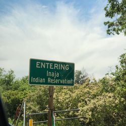
My best friend and I wanted to spend some time with nature. It was long overdue. This outing really satisfied our yearning. The terrain was a perfect distance for a good workout, 6m from the parking lot (corner of hwy 67 and Poway Rd). Suggestions to make your outing more enjoyable: water, snacks, hat, sunblock, hiking poles and phone for pics. When arriving at "Iron Mountain Staging Area" sign (pic), veer left. Likes: - Awesome views - 2 picnic tables - Restroom - Parking Happy hiking! read more


Awesome moderate hike. No shade so make sure to bring plenty of water I think the whole thing round-trip from the parking lot is only about 4 1/2 to 5 miles so shouldn't take you too long to get through it. There's a lot of switchbacks and a lot of dusty dirt roads. All in all family friendly dog friendly come out and enjoy the weather. read more


I've completed Mount Woodson 4 years ago, so I wasn't too intimidated by the length nor elevation of this hike in comparison. I also evolved my hiking game recently by buying the proper footwear and hiking poles (they're seriously a game changer). Today I hiked with my husband, and we started this hike at around 8:10-15ish a.m, reached the top at around 9:15, and after spending 15-20 minutes at the top, we were back in the parking lot at 11:00. Here are my tips: 1. Bring a hat, sunscreen, and tons of water. I hear it can get pretty brutal in the summer and at mid day, given it is in Poway and there's no shade after the initial tree-lined part. Luckily, we came today on a cloudy day. The low was 52 degrees with a high of about 60 by the time we left. It was perfect hiking weather, yet I still drank about 1 liter of water from my camelpak. 2. Be courteous when passing others. This is a heavily trafficked trail and lots of people bring their dogs here. If you're uncomfortable passing others on the narrow trail at times due to COVID, this is not the trail for you 3. Bring your own TP to use the bathroom. If nature calls and you must use the "bathroom" in the parking lot, it's pretty nasty. The toilet is basically a hole in the ground that doesn't flush. Think porta potty style. There is toilet paper, but it's the thin cheap kind, and if you find yourself in the unfortunate situation of running out of it, I'm sorry for you. I luckily only had to pee at the beginning, so I held my breath and didn't touch a thing inside 4. Bring a light snack for the top as a reward. I saw plenty of others eating a banana or granola bar at the top. One guy even had a cold canned beer (smart!). If you're used to fasting in the morning, this may not be necessary for you, but just a thought! Stay safe out there and happy hiking! read more


4 years ago
Great Hike. Did the loop; Iron Mountain via Ellie Lane Trail, totaling 7.8 miles. The first half of the trail, towards Iron Mountain, was a bit crowded. The narrow paths didn't allow much room for passing. The peak was crowded too. I would suggest an early start. We started the hike a little after at 7 am. The trail is rated "hard" / "difficult", but I would rate it moderate. Doable, just take your time. Lots of loose gravel and rocks. Wear hiking boots or use trekking poles for the descent. The second half hardly had any humans, which was great!! Peaceful. What to pack: plenty H2O (I finished my 2-liter bladder), sunblock (no shade), lots of snacks, and headphones...PLEASE! I love music but I don't want to listen to yours, especially on the trail... Get up and get out read more


6 years ago
Ok so I think its fair to point out that the 6 miles this trail represents isn't a great distance. 6 miles is an hour or an hour and a half walk. No big deal. But there are signs, and you can go the wrong way. I did that. And my girlfriend listened to me like a dum dum, and it turned into a 7 mile walk. Then I took a rock to the instep of my left foot. It hurt but I ignored it. But it hurt. And my girlfriend only weighs like 100lbs. Theres no way she could carry me out anyway so there was no point trying to get pitty. She would just make fun of me and call me cho de. We did the hike in like 2 hours. Mainly because we spent like 45 minutes on the top of the mountain talking and taking pics like tourists. The parking lot is only good if you get there before the sun. After the sun shows up 10,000 people get there and stare at you to see if youre leaving. But youre not. And they keep staring. Bathrooms are ehh. Lots of dust and Republicans not wearing masks and talking about conspiracies. Not sure whats worse. A rock to the foot, or a republican talking about how Biden is gonna be impeached. Lol. Ever wanna jump kick someone off a mountain? Ohh that sign that took us the wrong way was just before the mile and a half mark. Dont go right. Itll take you back to the parking lot. read more


4 years ago
My pup's were obsessed. As was I! Not a lot of shade on our walk, however.. There is shade in certain parts though, so it was not THAT bad as others have mentioned. I was pleasantly surprised with the amount of shade that was offered. My recommendation would be to ensure you go early a.m. hours because let's face it..once it hits 8AM, you're screwed. IF YOU HAVE PUPS with ya. If you dont mind the heat, go for it and risk a heat stroke but we are the 6 am' typa hikers ya feel me. Once that sun came out, it was like game over. We felt it. The trail was not challenging but also not flat. I was sore the next day and I loved that. specifically my hips and thighs. Nice right. We felt as though for our pups to tag along, they were not struggling, they enjoyed it and I was shocked they actually had energy when we got home...so clearly it was a good workout but at the same time, it was not their breaking point. Please note, with walking pretty swiftly, it took over an hour to get to the top. I am not sure if that is normal, but I'd say allow for 3 hours total. Maybe 2.5? I loved that there was a parking lot at the base. plenty of parking. OH and the restroom! Such a nice feature for visitors. Make sure you take potty bags and clean up after yourselves. We thought this was a beautiful hike that had a lot of lookout points and gorgeous scenery. read more


Our group attempted this hike on a late afternoon in July while SD was experiencing a heat wave. We started just before 5 pm, and the temperature was still in the mid-90s. There was plenty of available parking at the main trailhead lot so no one had to park curbside on Hwy 67. I had done this trail before, but unfortunately a few beginners were overwhelmed by the heat and had to stop about a 1/4 of the way into the trek. While they took a break in the shade, the rest of us continued the ascent and made it there in a little over an hour. I think people underestimate the challenge of Iron Mountain. It's not as difficult as nearby Potato Chip Rock, but it is a step up from Cowles Mountain because of the additional length. I did like the switchbacks as they were not as steep as Cowles can be. The view at the summit was very nice. We met up with those who rested on our way back. Everyone finished the remaining descent and made it back to the starting point well before sunset. Always be sure to bring enough water and dress appropriately for a hike like this. It doesn't hurt to be in reasonable physical shape too. read more


Hiking has become a fun part of living on the W coast. This is a popular one so make sure you get there early (parking) depends on the time of year and how nice the weather is going to be. No shade. Bring plenty of water, snacks, and good shoes . 5miles but a good hike read more

This hike is really pretty and quite a good distance if you want to kill a couple of hours hiking! I really enjoyed the different foliage around the hike. It's not as dead as other hikes I've been on in SD. It's also not the most strenuous, though it's long, the elevation isn't too bad and seems more gradual than cowels peak. The view from up top is really pretty but you kinda have to climb outwards to see anything. There's a bunch of bushes and shrubs at the top that block the view. There isn't a lot of shade here if depending on when you go so bring plenty of water especially on a hotter day! Parking is kind small but there seemed to be street parking along the sides before the lot. I came at an odd time 11pm on thanksgiving so I was lucky to find a spot. Some parts of the trail are pretty narrow so bring your mask and wear it if you have to pass others!! The trail is open but it does say masks are mandatory. Don't be the person who doesn't bring a mask and makes other uncomf please :-) read more


6 years ago
Loved this hike! About 6 miles round trip. In my opinion super easy! My friend and I didn't have to stop once, but if you're not feeling super confident or get tired you could easily stop to rest or for water a few times and still make it to the top easily! 10/10 is do this again! Took us about 2 hours- a little more if we count the time it took to stop for pictures. read more

7 years ago
Drove out on a Saturday morning around 1030 and the place was already packed! There is a parking lot , but it was full and a lot of people just park on the side of the road. To the top of iron mountain and back is just about 5 miles. It's a moderate hike with a steady incline and some rocks to climb over. For the most part, the trail is wide enough for 2 people to walk side by side. There is not much shade so do be prepared! Dogs on a leash are welcome.. I saw quite a few (don't forget water for them too!) there are dog bags available at the trail head. I saw people of all ages and athletic abilities on this trail. It's easy to take a rest break.. sitting in a rock if needed. All in all.. one of the better hikes I have been on. It was the perfect amount of activity for myself.. and my dog.. he loved it! Will definitely consider coming back.. probably a little earlier to beat the crowd and the heat! read more

The standard trail is a roundtrip of roughly 6miles with a 1000ft elevation gain. Beware that temps in Poway can be 15-20 degrees hotter than at the beaches, so definitely check Poway weather before hiking out there (especially with the pups). This is a very popular trail, so expect to pass people and dogs pretty frequently during the day and weekends. I personally love to do this trail at night when it is cooler and there are less people. There are trashcans and picnic tables at the top. If you are going during the day, and you want more privacy and a bigger workout, consider the Ellie Lane trail that abuts/merges with the Iron Mountain trail. If you take the Ellie Lane trail and go all the way to the peak of Iron Mountain, and return the same way, Strava shows me that it was just under 9.5 miles with a 2000+ foot elevation gain. read more


Took a hike a few days ago with the fam. Unfortunately due to COVID.. the restrooms were closed. I was glad to see a hand washing station provided though with soap! The trail is well maintained. You only get shade in the beginning under the trees, but later toward the afternoon you may get a bit more shade then usual. There was a good amount of people. I took my 5 y/o and he was able to do it fine. We went to the helipad and turned back around just because he was with us. Otherwise, we would have gone farther. Definitely a good turn around point for littles! Wear good shoes because you will be climbing rocks at some points! read more


Really nice trail, plenty of parking and well kept facilities. I went on Wednesday and it was nice and sparsely covered with hikers, although I can imagine the weekends are over-run with people. I don't live in the area, just down from LA for a dive in La Jolla and wanted to get in a hike while I was in the area and I ended up selecting this trail. The name "Iron Mtn" definitely could throw some people off thinking they can't do it, but it's a very manageable trail for various levels of hikers, although the heat of summer could definitely raise the bar on the hike. The trail is well maintained, but still nice and rugged in spots. Add in plenty of additional trails to add mileage and continue your adventures. read more


This is my go-to hike when I just want to get out, relax, and get some exercise. It's a moderate hike with just enough variety in terrain to keep things interesting, there are a couple of slightly steeper areas but nothing difficult or long, and then right back on an easy stretch of trail not long after to catch your breath if you need it. You can reach the top in 1.5 hours with just a very casual pace, and there are some picnic tables to relax at, and a few different areas to take in the view. Make sure you bring some water and maybe a light snack, and if it's sunny and hot bring a bit of cover to keep the sun off of you, there's a bit of shade but not much. read more


Tourist Trap... There are a few trails in San Diego that are so wildly popular that experienced hikers tend to avoid them like a bad rash. It's not so much the ant-trail of humanity zig-zagging up the mountain, but it's the selfish actions of a growing number of non-hikers with their bluetooth speakers blasting rap music (often with offensive lyrics). Another disturbing trend is the number of people taking their toy dogs to the top of these moderately difficult hikes. The sun beating down on people is one thing, but those poor short-legged dogs are forced on a Bataan death march over sharp rock trails with little shade. The actual hike to the top isn't too bad, but there's little in the way of shade which is a problem during most months. There's also some rather nasty trail conditions in some areas. You do need good hiking shoes on this trail because there's a lot of loose gravel. The top of Iron Mountain offers nice views of Poway and the San Vincente reservoir. Just find a boulder and take in the view. A few picnic tables are up there if you want to bring your lunch. This Mountain can be hiked by kids, but PLEASE bring hats and PLENTY OF WATER. Elite Tip - Take the Ellie Lane trail (loop) to the top of Iron Mountain to get a more challenging 9 mile hike with fewer people on the trail. Great views from the Ramona Viewpoint as well. Top "Tourist Trap" hikes in San Diego. - Cowles Mountain ( the worst behaved) - Potato Chip Rock ( Most overrated ) - Elfin forest - Torrey Pines - Iron Mountain read more


Page 1 of 13
More info about Iron Mountain
14847-14909 California Hwy 67
Poway, CA 92064
Directions
Hours
Indoor Amenities
Outdoor Amenities
Ask the Community - Iron Mountain
Is this beginner friendly hike? Looking to do more hiking with my friend!
The total distance is about 6 miles (out & back) with elevation gain of 1,125 ft. So it's rated as "moderate" (i.e., more difficult than "easy").
Is this hike open during the COVID-19 lockdown period?
Yes. No restrooms open though. Hand washing station available when we went!
Is this trail pretty clear to easily wear my babies on me for?
Not sure how old your kids are, but mine started hiking with hiking boots when she was about six. There are rattlesnakes - lots. Lake Poway is a much better place - row boats to rent, kids playground - ducks and wildlife and it's nice and cool. Iron… Read more
Review Highlights - Iron Mountain
You might also consider


Why does Yelp recommend reviews?
19 reviews that are not currently recommended
The reviews below are not factored into the business's overall star rating.
15 years ago
10 years ago
13 years ago
16 years ago
7 years ago
10 years ago
6 years ago
9 years ago
12 years ago
14 years ago
14 years ago
15 years ago
10 years ago
15 years ago
14 years ago
14 years ago
13 years ago
Iron Mountain - hiking - Updated June 2026
Best of Poway
People found Iron Mountain by searching for…
Things to Do in Poway, California
Night View in Poway, California
Star Gazing in Poway, California
Meteor Shower in Poway, California
Waterfall Hike in Poway, California
Scenic Drives in Poway, California
Hiking Trails in Poway, California
Secluded Spots in Poway, California
Easy Hikes in Poway, California
Hot Springs in Poway, California
Night Hike in Poway, California
Photo Spots in Poway, California
Full Moon Hike in Poway, California
Redwood Trees in Poway, California
Off Leash Dog Hiking Trails in Poway, California
Make Out Spot in Poway, California
Watch Sunset in Poway, California
Lookout Points in Poway, California
Stair Climbing in Poway, California
Trending Searches in Poway, CA
Bait And Tackle Shop near Iron Mountain
Black Owned Nail Salons near Iron Mountain
Boat Rental near Iron Mountain
Cliff Jumping near Iron Mountain
Dog Friendly Trails near Iron Mountain
Fishing Spots near Iron Mountain
Jet Ski Rental near Iron Mountain
Kayak Rental near Iron Mountain
Lakes & Ponds near Iron Mountain
Outdoor Activities near Iron Mountain
Pick Your Own Farms near Iron Mountain
Places To Walk Around near Iron Mountain
Public Shower near Iron Mountain
River Swimming near Iron Mountain
Rock Quarry near Iron Mountain
Scenic Night View near Iron Mountain
Scenic Overlook near Iron Mountain
Secluded Spots near Iron Mountain
Soccer Store near Iron Mountain
Strawberry Picking near Iron Mountain
Sunrise View near Iron Mountain
Swimming Holes near Iron Mountain
Swimming Lakes near Iron Mountain
Swimming Pools near Iron Mountain
Watch Sunset near Iron Mountain
Browse Articles
Browse Nearby
BEST of Poway, California Things to Do near Iron Mountain
BEST of Poway, California Restaurants near Iron Mountain
BEST of Poway, California Coffee near Iron Mountain
BEST of Poway, California Parks near Iron Mountain
BEST of Poway, California Breakfast near Iron Mountain
BEST of Poway, California Horseback Riding near Iron Mountain
Browse Brands
Related Searches in Poway, CA
Affordable Kayak Rental Services in Poway, California
Best Fishing Locations and Guides in Poway, California
Best Places for Horseback Riding in Poway, California
Best Waterfalls and Swimming Holes in Poway, California
Check Out Off Road Trails in Poway, California
Discover Dog Friendly Trails to Explore in Poway, California
Discover Scenic Mountain Bike Trails Near Poway, California
Discover Walking Parks in Poway, California Near You
Discover a Hiking Trail in Poway, California
Discover the Best Night Hike Trails in Poway, California
Discover the Best Running Track in Poway, California
Dog-Friendly Hikes With Dogs in Poway, California
Enjoy Camping Adventures Around Poway, California
Enjoy Exciting Mountain Biking Adventures in Poway, California
Enjoy Kayaking Adventures in Poway, California
Enjoy Tent Camping Spots Around Poway, California
Enjoy a Beautiful Waterfall Hike in Poway, California
Enjoy a Peaceful Nature Walk in Poway, California
Enjoy the Best Picnic Spots and Ideas in Poway, California
Enjoy the Best Walking Path in Poway, California
Enjoy the Best Walking Trails in Poway, California
Exciting Cliff Jumping Spots in Poway, California
Explore Beautiful Parks and Green Spaces in Poway, California
Explore Easy Hikes Perfect for All in Poway, California
Explore Fun Activities to Do in Poway, California
Explore Popular Campgrounds Near Poway, California
Explore the Best Beach Spots in Poway, California
Explore the Best Trail Options in Poway, California
Family Friendly Hiking With Kids in Poway, California
Find Beautiful Views in Poway, California
Find Popular Ziplining Spots Around Poway, California
Find the Best Parks for Picnics in Poway, California
Find the Best Scenic View Locations in Poway, California
Great Places to Walk in Poway, California
Hike the Popular Waterfall Trail in Poway, California
Hiking Trails With Waterfalls in Poway, California
Off Leash Dog Hiking Trails in Poway, California
Plan a Scenic Drive Route Near Poway, California
Popular Outdoor Activities to Try in Poway, California
Popular Picnic Spots to Visit in Poway, California
Safe River Swimming Areas in Poway, California
Safe and Fun Parks for Kids in Poway, California
Top Climbing Spots and Gyms in Poway, California
Top Paddleboarding Activities in Poway, California
Top Places for Snorkeling in Poway, California
Top Running Trails to Explore in Poway, California
Top Swimming Lakes to Enjoy in Poway, California
Top Swimming Spots and Pools in Poway, California
People who viewed Iron Mountain also viewed
Lake Poway Trail
64 reviews
Los Penasquitos Canyon Preserve
395 reviews
Mira Mesa, Torrey Hills
Stonewall Peak Trail
100 reviews
Old Mission Dam Trail
13 reviews
Devil's Jumpoff
4 reviews
Cuyamaca Peak
32 reviews
San Dieguito River Park
27 reviews
Rancho Bernardo
Goodan Ranch and Sycamore Canyon Open Space
12 reviews
Pacific Crest Trail At Penny Pines
22 reviews
Twin Peaks
13 reviews