Blue Sky Ecological Reserve Photos


You might also consider
More like Blue Sky Ecological Reserve
Recommended Reviews - Blue Sky Ecological Reserve
Start your review...

Reviews With Photos

My friend and I hike blue sky weekly and enjoy all the trail selections. Whether you want a leisurely stroll or a grueling hike, blue sky has it all. We meet up around 8 AM and there's always plenty of parking - by the time we leave people are waiting for our spots. The views and wildlife are beautiful and you often run into a docent on the weekends.

Parking available when we arrived at 12:30PM on an early March Sunday. The trail to Lake Ramona is well maintained and an easy, wide trail; except the last 15 mins or so was a steep incline to the top. Good view of Lake Poway and Lake Ramona at the top. Wild flowers are also blooming at this time of the year. Not much shade on this trail; however this early March Sunday was cool with temperature at mid 50s. Actually it was windy and cold at the top. It was a good hike if you have never been in n this trail. But I feel once is enough for me.

We did the Blue Sky Ecological Reserve Hike to Lake Ramona, approximately 6mi moderate intensity. It was a convenient hike to get to (it's in Poway) but gets very busy really early on Temperature: The majority of the hike is unshaded. We did the hike on a winter morning and for the first mile, my nose and lips were so cold I couldn't move them. I should have worn a mask to keep my face warm. Thereafter, I was able to shed my sweatshirt and build up a very light sweat. I wore sunglasses almost the whole time because there was a lot of glare from the sun. Difficulty: All sorts of terrain but primarily clearly marked dirt trail covered with pebbles. There were several sections with steep incline (my favorite part of hiking) but it was interspersed with more than enough periods of flat ground. Parking: Free lot. We arrived at 730 AM on a weekend and the lot was empty. By the time we left at 10:30 a.m., the lot was completely full.

I haven't been here in years, but it's still a magical place. If you don't see wildlife here, you may have been sprayed with wildlife repellent. The Overlook trail is a short out and back with a great view of the area, but there is no shade. Only Porta potties in the parking lot, and another on the trail. Farther up towards poway lake are bathrooms but they've never been open when we've been here.

If you don't want to pay the $10 Lake Poway parking fee, you can park here! You'll have to walk 2 miles to the lake... so it's not useful if you want to like have a picnic or bring things to hang out. We do this because we love the extra 4 miles (round trip) added on top of Mount Woodson/Potato Chip hike. Parking here and starting here elevates our hike to 11 miles round trip (instead of the 7 miles to the rock)! It's a damn good hike, burns like over 1200 calories. Also the reserve is beautiful. It easy to walk to, just flat until you ascend up to the lake.

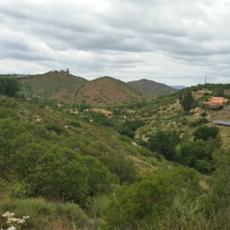
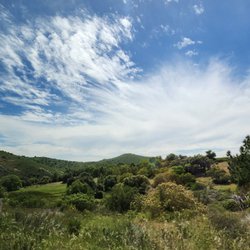
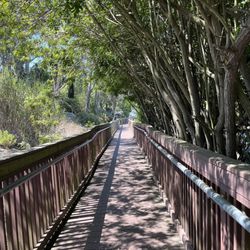
Really nicely done habitat conversation area albeit a bit small. Parking lot is a big plus vs. some other reserves where it's street parking only. One caveat, when you hike through here, most trails end up leaving the Blue Sky Reserve. The trail to Lake Poway ends up connecting up with the trailhead to Mt. Woodson, the most crowded trail in SD County. The trail to Lake Ramona also leaves the reserve. So, inside the reserve itself, there's only a small out and back trail. But the trail is unusually shaded by native oak forest. It's a great place for an easy, flat nature walk where you can spot acorn woodpeckers, etc. There are several informational placards, fairly wide and easily marked trails, and good signage too. Overall, Blue Sky nice place to enjoy the outdoors, but limited in terms of trails.


This is a very nice open trail. It is located very close to Mt. Woodson and I believe you can get to the Mt. Woodson hike on one of the side trails. If you feel like changing it up or adding 2+ miles, start here. The flat part is nice and shaded most of the way. At least 3 different routes to take off the main trail. If you do not take the side trail to Ramona or Lake Poway this is an easy 2.67 mile round trip walk. Took it easy this time since we did Iron Mountain the day before but next time we will hit a side trail for sure.

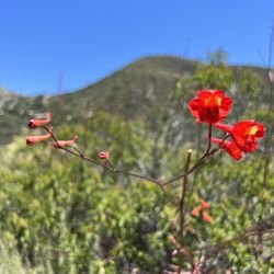
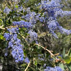
Gorgeous hiking area. Very well maintained south a dg path so you don't really need hiking shoes. Lake Ramona trail gets pretty steep so make sure you have packable layers if it's cold. You're going to get hot. There are porter potties at the beginning and middle of the trail and placards naming some of the plants. Right now there's a massive poppy bloom. It's really unbelievable, with the south facing hills on the Ramona trail looking completely orange. From the top of the trail near lake Ramona you can see the ocean. The end of the trail gets pretty steep so prepare for a cardio workout! Very beautiful trail. I think the poppies are going to be blooming for a while in a wave. Btw dogs allowed in leash.
A challenging family-friendly trail that can offer you a warm up to the other more challenging Poway hikes. Blue Sky Reserve starts off on the right foot with a nice parking lot. The trails here are wide and time tested. At about a mile in you'll get a path choice. I suggest you take the Ramona Lake path if you're looking for a nice uphill climb with great views on top of the Dam. The one bummer is that the trail itself is pretty crowded but not too bad. - There's a side trail called the Creekside Trail which should be considered mandatory because it's a great walk along oaks and thick green vegetation. The annoying - People blasting music while they hike. The stupid - People taking strollers to the top.

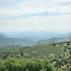
In order to find reeeeally beautiful hikes in San Diego, it always seems that you have to go fairly far from the city. Blue Sky Reserve is one of those unassuming spots that you would never expect would feel "nature-y," and yet some parts of it definitely make you feel like you're far from civilization. I checked out both lakes (Poway and Ramona) and the views were definitely worth it. I guess that San Diegans crave bodies of water (that are not the ocean), so maybe I was easily impressed, but if the cool lake views are not your thing, it was also a decent walk/workout towards the end. I would definitely recommend it!

I've been looking for a running trail for a long time. This one is perfect. Beginning is pretty flat but if you want a challenge you will eventually get some nice hill work. Views are beautiful. Many hikers on the trail with their dogs. This trail can get really hot so bring water for hydration and lots of sun screen. The poway sun can really beat down on ya. Have been back multiple times to run this trail. Plenty of parking and a clean portable potty at the entrance.

Such a beautiful hike! We went last Saturday with my sister and her three little ones, it was perfect for the kids and our four-legged family members! It's an easy enough trail to where you don't need super fancy hiking shoes, I wore my trainers and they worked perfectly! I definitely recommend this hike.
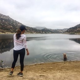
This was a pleasant hike that was north of the more famous Mount Woodson Trail (aka Potato Chip Rock) in Poway. You can actually choose your own adventure about 0.6 mile in with a less strenuous trek that headed south to Lake Poway or a tougher path east and then north that ascended to Lake Ramona. I chose the latter as it was only a round trip of about five miles. There were several switchbacks during the climb towards the summit. The hardest part came just short of Lake Ramona when the dirt became a black top pavement. The footing became better, but the steepness and stiff, swirling breezes made it a challenge. Once you reached the top, the reward was a beautiful view of the lake. There were a few folks who had arrived earlier, and they were armed with fishing poles. I had no idea how they were going to cast their lines because large boulders blocked the way down to the water. It took me exactly two hours from start to finish which included a little rest time at the peak to appreciate the view of the serene water. A bonus of the Blue Sky Ecological Reserve was that the parking lot at the trailhead was very well maintained. If this trail was longer, then I likely would have rated it with five stars. read more


Great spot for a peaceful hike. There are plenty of trails to explore. We ended up doing a 2-mile loop. The path has informative placards throughout, and I loved all the beautiful greenery along the way. There's a large parking lot nearby, and it wasn't crowded. We only saw a few other hikers. A lovely place to get outside and enjoy nature. read more


This review is for Blue Sky Canyon Trail which was a ~5.3 miles round trip that took ~2.5 hours to complete. Blue Sky Ecological Reserve is a popular and well maintained hiking spot that takes you to Lake Poway and Lake Ramona; located near Poway, California. Trail was mostly flat and slightly rocky near the beginning. The trail will eventually become an incline towards the top as you get closer to Lake Poway. Stunning views of the lake as you loop around it! No restrooms at the trailhead. However, there are restrooms at Lake Poway. Short video of the hike for those interested! https://youtu.be/FzeUhB761RU read more


6 months ago
My friend and I hike blue sky weekly and enjoy all the trail selections. Whether you want a leisurely stroll or a grueling hike, blue sky has it all. We meet up around 8 AM and there's always plenty of parking - by the time we leave people are waiting for our spots. The views and wildlife are beautiful and you often run into a docent on the weekends. read more


3 years ago
Parking available when we arrived at 12:30PM on an early March Sunday. The trail to Lake Ramona is well maintained and an easy, wide trail; except the last 15 mins or so was a steep incline to the top. Good view of Lake Poway and Lake Ramona at the top. Wild flowers are also blooming at this time of the year. Not much shade on this trail; however this early March Sunday was cool with temperature at mid 50s. Actually it was windy and cold at the top. It was a good hike if you have never been in n this trail. But I feel once is enough for me. read more


We did the Blue Sky Ecological Reserve Hike to Lake Ramona, approximately 6mi moderate intensity. It was a convenient hike to get to (it's in Poway) but gets very busy really early on Temperature: The majority of the hike is unshaded. We did the hike on a winter morning and for the first mile, my nose and lips were so cold I couldn't move them. I should have worn a mask to keep my face warm. Thereafter, I was able to shed my sweatshirt and build up a very light sweat. I wore sunglasses almost the whole time because there was a lot of glare from the sun. Difficulty: All sorts of terrain but primarily clearly marked dirt trail covered with pebbles. There were several sections with steep incline (my favorite part of hiking) but it was interspersed with more than enough periods of flat ground. Parking: Free lot. We arrived at 730 AM on a weekend and the lot was empty. By the time we left at 10:30 a.m., the lot was completely full. read more


1 year ago
10 months ago
I haven't been here in years, but it's still a magical place. If you don't see wildlife here, you may have been sprayed with wildlife repellent. The Overlook trail is a short out and back with a great view of the area, but there is no shade. Only Porta potties in the parking lot, and another on the trail. Farther up towards poway lake are bathrooms but they've never been open when we've been here. read more


If you don't want to pay the $10 Lake Poway parking fee, you can park here! You'll have to walk 2 miles to the lake... so it's not useful if you want to like have a picnic or bring things to hang out. We do this because we love the extra 4 miles (round trip) added on top of Mount Woodson/Potato Chip hike. Parking here and starting here elevates our hike to 11 miles round trip (instead of the 7 miles to the rock)! It's a damn good hike, burns like over 1200 calories. Also the reserve is beautiful. It easy to walk to, just flat until you ascend up to the lake. read more


Really nicely done habitat conversation area albeit a bit small. Parking lot is a big plus vs. some other reserves where it's street parking only. One caveat, when you hike through here, most trails end up leaving the Blue Sky Reserve. The trail to Lake Poway ends up connecting up with the trailhead to Mt. Woodson, the most crowded trail in SD County. The trail to Lake Ramona also leaves the reserve. So, inside the reserve itself, there's only a small out and back trail. But the trail is unusually shaded by native oak forest. It's a great place for an easy, flat nature walk where you can spot acorn woodpeckers, etc. There are several informational placards, fairly wide and easily marked trails, and good signage too. Overall, Blue Sky nice place to enjoy the outdoors, but limited in terms of trails. read more


3 years ago
This is a very beautiful reserve. The views are impressive and it is not a long hike. We didn't do the full distance. read more


This is a very nice open trail. It is located very close to Mt. Woodson and I believe you can get to the Mt. Woodson hike on one of the side trails. If you feel like changing it up or adding 2+ miles, start here. The flat part is nice and shaded most of the way. At least 3 different routes to take off the main trail. If you do not take the side trail to Ramona or Lake Poway this is an easy 2.67 mile round trip walk. Took it easy this time since we did Iron Mountain the day before but next time we will hit a side trail for sure. read more


Gorgeous hiking area. Very well maintained south a dg path so you don't really need hiking shoes. Lake Ramona trail gets pretty steep so make sure you have packable layers if it's cold. You're going to get hot. There are porter potties at the beginning and middle of the trail and placards naming some of the plants. Right now there's a massive poppy bloom. It's really unbelievable, with the south facing hills on the Ramona trail looking completely orange. From the top of the trail near lake Ramona you can see the ocean. The end of the trail gets pretty steep so prepare for a cardio workout! Very beautiful trail. I think the poppies are going to be blooming for a while in a wave. Btw dogs allowed in leash. read more


A challenging family-friendly trail that can offer you a warm up to the other more challenging Poway hikes. Blue Sky Reserve starts off on the right foot with a nice parking lot. The trails here are wide and time tested. At about a mile in you'll get a path choice. I suggest you take the Ramona Lake path if you're looking for a nice uphill climb with great views on top of the Dam. The one bummer is that the trail itself is pretty crowded but not too bad. - There's a side trail called the Creekside Trail which should be considered mandatory because it's a great walk along oaks and thick green vegetation. The annoying - People blasting music while they hike. The stupid - People taking strollers to the top. read more


6 years ago
In order to find reeeeally beautiful hikes in San Diego, it always seems that you have to go fairly far from the city. Blue Sky Reserve is one of those unassuming spots that you would never expect would feel "nature-y," and yet some parts of it definitely make you feel like you're far from civilization. I checked out both lakes (Poway and Ramona) and the views were definitely worth it. I guess that San Diegans crave bodies of water (that are not the ocean), so maybe I was easily impressed, but if the cool lake views are not your thing, it was also a decent walk/workout towards the end. I would definitely recommend it! read more

I've been looking for a running trail for a long time. This one is perfect. Beginning is pretty flat but if you want a challenge you will eventually get some nice hill work. Views are beautiful. Many hikers on the trail with their dogs. This trail can get really hot so bring water for hydration and lots of sun screen. The poway sun can really beat down on ya. Have been back multiple times to run this trail. Plenty of parking and a clean portable potty at the entrance. read more


6 years ago
Such a beautiful hike! We went last Saturday with my sister and her three little ones, it was perfect for the kids and our four-legged family members! It's an easy enough trail to where you don't need super fancy hiking shoes, I wore my trainers and they worked perfectly! I definitely recommend this hike. read more

The hike at Blue Sky is a short but steep one. The 5 mile round-trip hike took roughly 2 hours (but we got lost on the way up haha). It's a very rewarding view of the calm lake at the end. Definitely recommend for a quick, morning hike. read more

6 years ago
7 years ago
I love running here. It has a nice flat trail for a little while then it takes you up to Ramona's Lake. There are so many birds (quail) and beautiful plants to look at! I also enjoy the tree coverage for the first mile or so! read more


6 years ago
Great hike! The way to Lake Poway I call a miniature Iron Mountain and try way to Lake Ramona is like a mini Mt. Woodson read more


7 years ago
This is a nice little park! I walked up to Lake Ramona - to the back gate and back for a distance of a little over 7.5 miles. The "trail" is a road and it is nearly all flat until you get to the dam, then there is a climb up the road for about a mile. There are some very nice signs that tell what the vegetation is - and if you check out the parking lot, you can go on guided tours. There was a flyer for an upcoming "star gazing" walk at night that also looked interesting. There were a few interesting birds - but I didn't see anymore living creatures except the hikers that kept passing me up. I enjoyed this place and may come back! read more


11 years ago
It's a beautiful trail, what more can I say? The more you explore the more secret spots you can discover. The best parts of the trail are the ones off of the main spots. I live close so I frequently come here (once a week, some weeks every day) to read and relax. Of course depending on your preference this can lead to Ramona lake, which is AMAZING and you can swim in it, or Poway Lake, equally amazing though no swimming but it has a family picnic area. Would recommend to any San Diegans to come check it out! read more


Came here last weekend and boy was that a hike. Not as crazy as ones I've been on. But that uphill, gets me every time. We went on both trails, to Lake Ramona and to Lake Poway. Lake Ramona was much more uphill than Poway. My knees were giving up on me by the end. We should have taken Lake Ramona first. But it's a beautiful hike first walking in, and the end game is even better. Good thing we didn't bring our little dog, he would hate us and have us carry him. Hah read more


8 years ago
Great views, and atmosphere. Beautiful sights. It's a very clean hiking trail and well maintained. read more


Feelin hot hot hot! There were heat advisory signs telling visitors to bring lots of water and they were no joke! I did go around noon so I can't complain. It was a lovely hike, take the Creekside trail for a little off shoot with more shade. There are cool informative signs describing some of the local plants as you walk along a very well maintained easy hike. We ended up going to Lake Poway, the breeze when we headed down toward the lake was fantastic. The views were amazing! read more


16 years ago
A few friends and I hiked around Blue Sky this weekend and we loved it. It was a nice change of pace and the nature was pretty. The actual hiking in Blue Sky is quite easy, but still relaxing and gets the blood going. We took the "Creekside" trail which is a sun-dappled trail that takes you through some lovely vegetation and I would imagine it would be very nice in the summer since it's mostly in shade. The damage from the Witch Fire is still quite evident and it's sombering to see the devastation. If you reach the end of Blue Sky, you can actually take the Lake Poway or Lake Ramona trails up the hill and go to the respective lakes. My friends and I went up the Lake Poway trail, which got quite steep in some parts, but the views were beautiful once at the top. We saw families, hikers young and old, and people with dogs, so I think this is suitable for all. This was a great weekend hike with beautiful views. read more


9 years ago
Cannot believe this place was a short 15 min drive from home! The walk through the woods was lovely, and did not feel like it was an in close proximity to urbanization. We did the lake poway trail, and throughout the hike we saw amazing wildflowers. There was quite high foot traffic when we went, but not too crowded or congested. The views were lovely, and a great hike to do when you are on a time crunch but still want to be outside. read more


8 years ago
There are so many different trails to explore! This was a fun and super easy 4 mile hike with many nice views. I chose the Lake Poway route & will come check out the Ramona scenery. read more


16 years ago
10 years ago
Nice wide trails, partially shaded by trees for the first mile, then uphill switchbacks in full sun to the top of the dam. Yes, the last 1/2 mile to the top is steep, but that's why you hike it. Great views and plenty of wildlife. Sure, plenty of swimmers, but only seen a truck 2-3 times on the trail in the years we have been hiking it. Perks: no speeding mountain bikers devoid of any wilderness etiquette. Downside: rarely cleaned port-o-potties, and too many irresponsible dog owners. Worth a trip. Only available drinking water is in the parking lot, so heed the signs and bring it with you. read more


14 years ago
Page 1 of 2
More info about Blue Sky Ecological Reserve
16275 Espola Rd
Poway, CA 92064
Directions
(858) 668-4781
Call Now
Visit Website
http://www.blueskyreserve.org/
Hours
Indoor Amenities
Outdoor Amenities
Ask the Community - Blue Sky Ecological Reserve
Review Highlights - Blue Sky Ecological Reserve
You might also consider


Why does Yelp recommend reviews?
4 reviews that are not currently recommended
The reviews below are not factored into the business's overall star rating.
10 years ago
2 years ago
10 years ago
1 year ago
Blue Sky Ecological Reserve - hiking - Updated July 2026
Best of Poway
People found Blue Sky Ecological Reserve by searching for…
Trending Searches in Poway, CA
Browse Articles
Browse Nearby
BEST of Poway, California Restaurants near Blue Sky Ecological Reserve
BEST of Poway, California Coffee near Blue Sky Ecological Reserve
BEST of Poway, California Things to Do near Blue Sky Ecological Reserve
BEST of Poway, California Parks near Blue Sky Ecological Reserve
BEST of Poway, California Breakfast near Blue Sky Ecological Reserve
BEST of Poway, California Horseback Riding near Blue Sky Ecological Reserve
BEST of Poway, California Campgrounds near Blue Sky Ecological Reserve
Browse Brands
Related Searches in Poway, CA
Affordable Kayak Rental Services in Poway, California
Best Fishing Locations and Guides in Poway, California
Best Places for Horseback Riding in Poway, California
Best Waterfalls and Swimming Holes in Poway, California
Check Out Off Road Trails in Poway, California
Discover Dog Friendly Trails to Explore in Poway, California
Discover Scenic Mountain Bike Trails Near Poway, California
Discover Walking Parks in Poway, California Near You
Discover a Hiking Trail in Poway, California
Discover the Best Night Hike Trails in Poway, California
Discover the Best Running Track in Poway, California
Dog-Friendly Hikes With Dogs in Poway, California
Enjoy Camping Adventures Around Poway, California
Enjoy Exciting Mountain Biking Adventures in Poway, California
Enjoy Kayaking Adventures in Poway, California
Enjoy Tent Camping Spots Around Poway, California
Enjoy a Beautiful Waterfall Hike in Poway, California
Enjoy a Peaceful Nature Walk in Poway, California
Enjoy the Best Picnic Spots and Ideas in Poway, California
Enjoy the Best Walking Path in Poway, California
Enjoy the Best Walking Trails in Poway, California
Exciting Cliff Jumping Spots in Poway, California
Explore Beautiful Parks and Green Spaces in Poway, California
Explore Easy Hikes Perfect for All in Poway, California
Explore Fun Activities to Do in Poway, California
Explore Popular Campgrounds Near Poway, California
Explore the Best Beach Spots in Poway, California
Explore the Best Trail Options in Poway, California
Family Friendly Hiking With Kids in Poway, California
Find Beautiful Views in Poway, California
Find Popular Ziplining Spots Around Poway, California
Find the Best Parks for Picnics in Poway, California
Find the Best Scenic View Locations in Poway, California
Great Places to Walk in Poway, California
Hike the Popular Waterfall Trail in Poway, California
Hiking Trails With Waterfalls in Poway, California
Off Leash Dog Hiking Trails in Poway, California
Plan a Scenic Drive Route Near Poway, California
Popular Outdoor Activities to Try in Poway, California
Popular Picnic Spots to Visit in Poway, California
Safe River Swimming Areas in Poway, California
Safe and Fun Parks for Kids in Poway, California
Top Climbing Spots and Gyms in Poway, California
Top Paddleboarding Activities in Poway, California
Top Places for Snorkeling in Poway, California
Top Running Trails to Explore in Poway, California
Top Swimming Lakes to Enjoy in Poway, California
Top Swimming Spots and Pools in Poway, California
People who viewed Blue Sky Ecological Reserve also viewed
Lake Poway Trail
64 reviews
Black Mountain Open Space Park
56 reviews
Mira Mesa, Torrey Hills
San Dieguito River Park
27 reviews
Rancho Bernardo
Goodan Ranch and Sycamore Canyon Open Space
12 reviews
Cleveland National Forest
35 reviews
Twin Peaks
13 reviews
Los Penasquitos Canyon Preserve
395 reviews
Mira Mesa, Torrey Hills
Battle Mountain
11 reviews
Rancho Bernardo
Old Mission Dam Trail
13 reviews
Lake Miramar
500 reviews
Scripps Ranch