Lake Poway Trail Photos


You might also consider
More like Lake Poway Trail
Recommended Reviews - Lake Poway Trail
Start your review...

Reviews With Photos

This review is for the Blue Sky Canyon Trail (AllTrails) which was an additional 1.4 miles that includes the ~2.8 miles around Lake Poway. Total round trip was ~5.4 miles and took around 2.5 hours. Free parking at the Blue Sky Ecological Reserve. Plenty of inclines as you get closer to the lake and nice views of Lake Poway!


This was the first time I had actually hiked around the entire perimeter of Lake Poway. On previous visits, it was halfway around and then take the path upward to Mount Woodson for a photo opportunity at Potato Chip Rock. One other time, I stayed above the lake and headed northeast towards the dam at Lake Ramona. My starting point was the Blue Sky Ecological Reserve trailhead on Espola Rd. There's plenty of parking in that lot. It's also free unlike parking on-site at the Lake Poway Recreational Office which charges a $10 fee for non-Poway residents on weekends. The trail starts off quite flat as you head east for about a mile. At that point, you can continue eastward to Lake Ramona or turn right and head south towards Lake Poway. The trail then allows you to go clockwise or counterclockwise around the lake. Either choice requires climbing a few switchbacks with some moderate slope. The ascent was easily the hardest part of the trek. I decided to go counterclockwise so that I would approach the recreational office first. One can buy permits to go fishing at the edge of the lake. I saw a few anglers doing that during my mid-afternoon weekday hike. What I really enjoyed about going around this lake was that the terrain was not flat ala Lake Miramar or Lake Murray. There were some gradual inclines and declines throughout the circumnavigation. I saw many leashed dogs and a few mountain bikers on the trail. Shaded areas popped up at numerous spots. There were also picnic tables and porta-johns at several locations for breaks. By the time I had completed a loop around the lake, the traveled distance was about four miles. The entire length from start to finish was roughly 5.3 miles and took well under two hours to complete. For an easy to moderate hike, I rated the Lake Poway Trail four stars.

Came here with a friend and my pup one Saturday morning in January. I didn't realize there would be a fee to get to the trailhead but it's placed within a city park, so I get it. That said, a of January 2022, be aware there is $10 entry fee per car - I paid cash but I believe you could pay with card as well. You could avoid this by using the street parking in the neighborhood across the traffic light from the park entrance but this would add at least half a mile to your hike. My advice is to check it all out first. My friend and I met in the neighborhood, parked one car there and took the other car in - I recommend this hybrid approach. :) Once inside, the trail is marked. It starts at the lake and is across from the baseball diamond. When we did it, it was about 7.5mile to Potato chip rock and back - there is a fair amount of climb (my apple watch said about 1000ft over 3 miles) but once you're up there, its all back down hill from there. :) There are lots of places to stop, sit on rocks, picnic, etc. Its very dog friendly and highly trafficked (even in January) so we felt very safe. I definitely recommend bringing lots of water and your own poop bags if you do bring your dog (there are none available on the trail). The potato chip rock part is the top of the mountain and has lots of people taking photos, resting, etc - and I'm pretty sure this was not the busiest day - so I recommend going very early if its summer! If we had time, we would have loved hanging out at the lake after, maybe picnic, etc. I would go back for that all day type of event for sure - makes paying for parking worth it. :)

Great place to enjoy the outdoors! They have two different parking lots . The main parking lot I believe has a small parking fee of $10 and the blue skyy parking lot is free( but you will have to walk about 2 miles ) in order to get to lake poway . The main trail leads to multiple trails . & depending the day and hour you choose to go, it can get packed and not everyone wears a mask . I personally did the back way trail that lead to lake poway . It's a great little hike with restrooms available and picnic tables . I suggest you wear some comfortable shoes because you will be going up hills and through rocks . Be alert at all times , snakes and animals can pop out . Also take some water and a snack . Don't forget your sunscreen and bug spray . Overall I personally loved the view , I have nothing bad to say about this trail .. Definitely a place I would visit again . Nothing to hard nor to easy . So if you love the outdoors and you are you for a challenge with a beautiful view this is a must . Stay safe. .

Lake Poway Loop Trail is one of my new favorite trails. You get a bit of everything but not too much of it. This is a perfect "bridge" between casual flat trails and the more strenuous mountains in San Diego. It's also a good proving ground if you're wanting to see how your family and kids can handle hills and some steep climbs. The loop trail is well maintained with several chem-cans and benched along the way. Better to go early in the morning or later in the afternoon to avoid the sun beating down on you. Great views all along the way. - Tip To avoid the Poway Park Fee ( and add some more hiking), start your hike from the blue sky ecological reserve. Parking is free, and you'll get a few more miles under your hiking boots. The total mileage from Blue Sky to the Lake Poway Trail, to walk the loop, and hike back was 6 miles. If you start directly at the Poway park, you're only looking at about 3.. - Not the nicest people on the trail. Getting a smile, hello, or nod from fellow hikers is hard to come here.. About 50%...Most trails are at 80% or higher.

I am lucky enough to live close to Lake Poway, and it has become our go-to Sat morning hike spot. Well-maintained trails, rarely crowded although not so quiet that one feels completely alone (for better or worse!). Benches and shade structures along the way for a break if desired. Not a flat hike at all- quite hilly with many switchbacks so be prepared. Definitely carry water for yourself and dog(s). Love the turkey vultures, the ducks, the occasional goose or egret. Just so peaceful and beautiful.

The Lake Poway trail itself is about 2.7 miles and is anything but easy. It's very approachable, but if you do the full trail, either way, there will be at least 1/2 mile of cardio involved, as there is a steep ascent. Good walking shoes are a must, as there are some downhills that will cause a fall if your footwear is not up to snuff. There is a plethora of wildlife on this trail, squirrels, insects, lizards, hummingbirds, hawks, AND rattlesnakes, so keep your eyes and ears open. The vistas are truly amazing, and this is a great way to get exercise. If you keep a good pace, the trail loop takes about 75 minutes. Bring PLENTY of water, as there is none available on the trail itself.

Did you know if you run this trail at sunset you get a free protein shot?? Read on for details! This is by far my favorite running trail! It's technical, there are downhill bits that are fun but not dangerous where you can feel like you're flying... twisty bits... nice views... not crowded (BUT avoid weekends! This place is a tourist attraction because of potato chip rock, which is accessible from this trail). If you navigate the inner loop it's about 4.2 km (2.61 miles). So, not quite a 5k. BUT! Elevation change is 135 m (443 feet). In a couple places it's super steep and will have you cursing the jerk who wrote that review on Yelp that fooled you into trying to run the trail... so, fair warning, this trail is probably only going to be fun for you to run if you're a stubborn, masochistic, risk-embracing trail runner. The trail, from a running perspective, is one of the more technical I have run. There's a lot of places where you're looking down almost continuously because of irregular terrain, steep declines, twists and turns, and elevation change. That said, most of it is actually smooth and relaxing! The technical parts are hard, but probably only 20% of the trail qualifies as technical. If you slow down to a jog or walk in those places (and maybe on the steep inclines too), the whole thing becomes totally doable even for intermediate level runners / joggers by the way - in case you're worried! The views really are beautiful. About 60% of the path is directly around the lake. The remainder is on the other side of the dam, and there's no real view to speak of in that part unfortunately. But still, the majority of this trail is very pretty. The path here isn't super clearly marked. There's a number of intersections where you can deduce the right direction, but it's not always explicitly marked. A slight issue. Just pay attention and think about where the lake / parking lot is. Parking is free if you're a resident of Poway and bring proof of residency. They are liberal about accepting various mail that may be addressed to you (I used mail from my employer, because I just moved here and my license hasn't been updated yet). There are, surprisingly, portapotties spread throughout the trail. I haven't used them, but just so you know... The only thing that you really need to be aware of is that around dusk, the bugs come out. I've run this trail four times now, and every time I do it in the late afternoon when it's cooling down, I always end eating a few bugs. There really can be quite a few... yoiks! But hey, free protein shot... right? :-p

This review is for the actual "Lake Poway Trail", not Mt. Woodson, Potato Chip Rock, etc. It's a 2.7 mile trail around Lake Poway. I would say that it's not for beginners. I believe the hiking trails call it intermediate. Friends told me it was a beginner trail, so the first time I out I was pretty sure I was going to have a heart attack...lol. But I've been doing it several times a week for 2 months and it's gotten much easier. You can head either direction and both ways have some fairly steady, steep uphill switchbacks. But there is also quite a bit of semi-flat areas as well. You get plenty of time on these so you can catch your breath (if you're a beginner.) I really enjoy this place. Parking is free during the week. All the people I've encountered have been very friendly. Plus it's really quite beautiful. Our next trek is getting to Potato Chip rock....maybe I'll see you there!

It's beautiful here and I love how many options you have for trails. The view once you're on top is rather worth it. The lake is absolutely beautiful when you're looking at it as you're going up. Some of the trails get a little strenuous but maybe it's just because I'm out of shape. You can still see parts of the trail that is still recovering from the fire. The trees are black in some areas and it's really sad to see that. I took my dogs here and they ran around the trails without much of an issue.

I have discovered walking/jogging/hiking trails. This trail is part of the route getting the the Potato Chip rock. I do like it. It's great, if you venture along the lake you can actually walk on the single tracks next to it. You have your picnic tables and bathrooms. It is a great place to take the family. While you are here maybe you can convince them to join you for a hike up the hill. This place is good for kids since Lake Poway have playgrounds that the kids can vent all their extra energy. There is also fishing, I have noticed a few folks in their boat trying to bait some fish.


This review is for the Lake Poway Loop Trail, not for Mt. Woodson Trail which is 7.8 miles roundtrip. Lake Poway Loop Trail is a great easy hike! It's labeled as moderate but it is quite easy with only a few slight inclines. If you go clockwise on the loop and turn left on the trailhead, the beginning is more challenging than the end. There's not much shade on the trail so I suggest going in the morning or on a cooler day. There's views of the mountains and the greenery in the beginning and views of the lake on the second half of the trail. The trail itself is very well maintained with clean benches for seating, port-a potties, and a few trash cans along the way especially near the lake. $10 parking fee on weekends and holidays, but free on weekdays. When parking, walk towards the snack bar building and the boat rentals on the water and you'll see the start of the trailhead. It is 2.8 miles round trip and about one hour long. Dog friendly with dogs on leash. read more


This is a really nice trail surrounded by beautiful views! My only recommendation would be to start on the right side of the lake where the trail is paved rather than the left dirt path because that one is definitely more difficult. I wouldn't recommend this trail on a hot day because there is very little to no shade on the dirt path. Parking: There is a parking lot near the trail and lake that has plenty of spots. Free on weekdays, $10 to enter on weekends for non-Poway residents. Amenities: There are benches and picnic tables along the lake and grass, and a few along the trail as well. Restrooms are surprisingly well-maintained with running water and soap. There is a snack shop that sells various treats and is an asset to have while you're out in the heat. Ambience: Very peaceful. There is no outside noise, it really is a hidden spot for some quiet and time away from the busy city. On the bright side, it's only a mile or two away from the closest grocery store so you're not completely out in the wilderness. read more


This review is for the Blue Sky Canyon Trail (AllTrails) which was an additional 1.4 miles that includes the ~2.8 miles around Lake Poway. Total round trip was ~5.4 miles and took around 2.5 hours. Free parking at the Blue Sky Ecological Reserve. Plenty of inclines as you get closer to the lake and nice views of Lake Poway! read more


6 years ago
Easy trail which loops around the lake. Walked to the right, past a lot of people fishing to a fork. The one that goes up takes you on the 2.9mi loop. There is some elevation. Everyone I walked by in the trail had a mask on. The water is really clean. Dog friendly too. read more

This was the first time I had actually hiked around the entire perimeter of Lake Poway. On previous visits, it was halfway around and then take the path upward to Mount Woodson for a photo opportunity at Potato Chip Rock. One other time, I stayed above the lake and headed northeast towards the dam at Lake Ramona. My starting point was the Blue Sky Ecological Reserve trailhead on Espola Rd. There's plenty of parking in that lot. It's also free unlike parking on-site at the Lake Poway Recreational Office which charges a $10 fee for non-Poway residents on weekends. The trail starts off quite flat as you head east for about a mile. At that point, you can continue eastward to Lake Ramona or turn right and head south towards Lake Poway. The trail then allows you to go clockwise or counterclockwise around the lake. Either choice requires climbing a few switchbacks with some moderate slope. The ascent was easily the hardest part of the trek. I decided to go counterclockwise so that I would approach the recreational office first. One can buy permits to go fishing at the edge of the lake. I saw a few anglers doing that during my mid-afternoon weekday hike. What I really enjoyed about going around this lake was that the terrain was not flat ala Lake Miramar or Lake Murray. There were some gradual inclines and declines throughout the circumnavigation. I saw many leashed dogs and a few mountain bikers on the trail. Shaded areas popped up at numerous spots. There were also picnic tables and porta-johns at several locations for breaks. By the time I had completed a loop around the lake, the traveled distance was about four miles. The entire length from start to finish was roughly 5.3 miles and took well under two hours to complete. For an easy to moderate hike, I rated the Lake Poway Trail four stars. read more


Came here with a friend and my pup one Saturday morning in January. I didn't realize there would be a fee to get to the trailhead but it's placed within a city park, so I get it. That said, a of January 2022, be aware there is $10 entry fee per car - I paid cash but I believe you could pay with card as well. You could avoid this by using the street parking in the neighborhood across the traffic light from the park entrance but this would add at least half a mile to your hike. My advice is to check it all out first. My friend and I met in the neighborhood, parked one car there and took the other car in - I recommend this hybrid approach. :) Once inside, the trail is marked. It starts at the lake and is across from the baseball diamond. When we did it, it was about 7.5mile to Potato chip rock and back - there is a fair amount of climb (my apple watch said about 1000ft over 3 miles) but once you're up there, its all back down hill from there. :) There are lots of places to stop, sit on rocks, picnic, etc. Its very dog friendly and highly trafficked (even in January) so we felt very safe. I definitely recommend bringing lots of water and your own poop bags if you do bring your dog (there are none available on the trail). The potato chip rock part is the top of the mountain and has lots of people taking photos, resting, etc - and I'm pretty sure this was not the busiest day - so I recommend going very early if its summer! If we had time, we would have loved hanging out at the lake after, maybe picnic, etc. I would go back for that all day type of event for sure - makes paying for parking worth it. :) read more

Great place to enjoy the outdoors! They have two different parking lots . The main parking lot I believe has a small parking fee of $10 and the blue skyy parking lot is free( but you will have to walk about 2 miles ) in order to get to lake poway . The main trail leads to multiple trails . & depending the day and hour you choose to go, it can get packed and not everyone wears a mask . I personally did the back way trail that lead to lake poway . It's a great little hike with restrooms available and picnic tables . I suggest you wear some comfortable shoes because you will be going up hills and through rocks . Be alert at all times , snakes and animals can pop out . Also take some water and a snack . Don't forget your sunscreen and bug spray . Overall I personally loved the view , I have nothing bad to say about this trail .. Definitely a place I would visit again . Nothing to hard nor to easy . So if you love the outdoors and you are you for a challenge with a beautiful view this is a must . Stay safe. . read more


Lake Poway Loop Trail is one of my new favorite trails. You get a bit of everything but not too much of it. This is a perfect "bridge" between casual flat trails and the more strenuous mountains in San Diego. It's also a good proving ground if you're wanting to see how your family and kids can handle hills and some steep climbs. The loop trail is well maintained with several chem-cans and benched along the way. Better to go early in the morning or later in the afternoon to avoid the sun beating down on you. Great views all along the way. - Tip To avoid the Poway Park Fee ( and add some more hiking), start your hike from the blue sky ecological reserve. Parking is free, and you'll get a few more miles under your hiking boots. The total mileage from Blue Sky to the Lake Poway Trail, to walk the loop, and hike back was 6 miles. If you start directly at the Poway park, you're only looking at about 3.. - Not the nicest people on the trail. Getting a smile, hello, or nod from fellow hikers is hard to come here.. About 50%...Most trails are at 80% or higher. read more


I am lucky enough to live close to Lake Poway, and it has become our go-to Sat morning hike spot. Well-maintained trails, rarely crowded although not so quiet that one feels completely alone (for better or worse!). Benches and shade structures along the way for a break if desired. Not a flat hike at all- quite hilly with many switchbacks so be prepared. Definitely carry water for yourself and dog(s). Love the turkey vultures, the ducks, the occasional goose or egret. Just so peaceful and beautiful. read more


3 years ago
The Lake Poway trail itself is about 2.7 miles and is anything but easy. It's very approachable, but if you do the full trail, either way, there will be at least 1/2 mile of cardio involved, as there is a steep ascent. Good walking shoes are a must, as there are some downhills that will cause a fall if your footwear is not up to snuff. There is a plethora of wildlife on this trail, squirrels, insects, lizards, hummingbirds, hawks, AND rattlesnakes, so keep your eyes and ears open. The vistas are truly amazing, and this is a great way to get exercise. If you keep a good pace, the trail loop takes about 75 minutes. Bring PLENTY of water, as there is none available on the trail itself. read more


Did you know if you run this trail at sunset you get a free protein shot?? Read on for details! This is by far my favorite running trail! It's technical, there are downhill bits that are fun but not dangerous where you can feel like you're flying... twisty bits... nice views... not crowded (BUT avoid weekends! This place is a tourist attraction because of potato chip rock, which is accessible from this trail). If you navigate the inner loop it's about 4.2 km (2.61 miles). So, not quite a 5k. BUT! Elevation change is 135 m (443 feet). In a couple places it's super steep and will have you cursing the jerk who wrote that review on Yelp that fooled you into trying to run the trail... so, fair warning, this trail is probably only going to be fun for you to run if you're a stubborn, masochistic, risk-embracing trail runner. The trail, from a running perspective, is one of the more technical I have run. There's a lot of places where you're looking down almost continuously because of irregular terrain, steep declines, twists and turns, and elevation change. That said, most of it is actually smooth and relaxing! The technical parts are hard, but probably only 20% of the trail qualifies as technical. If you slow down to a jog or walk in those places (and maybe on the steep inclines too), the whole thing becomes totally doable even for intermediate level runners / joggers by the way - in case you're worried! The views really are beautiful. About 60% of the path is directly around the lake. The remainder is on the other side of the dam, and there's no real view to speak of in that part unfortunately. But still, the majority of this trail is very pretty. The path here isn't super clearly marked. There's a number of intersections where you can deduce the right direction, but it's not always explicitly marked. A slight issue. Just pay attention and think about where the lake / parking lot is. Parking is free if you're a resident of Poway and bring proof of residency. They are liberal about accepting various mail that may be addressed to you (I used mail from my employer, because I just moved here and my license hasn't been updated yet). There are, surprisingly, portapotties spread throughout the trail. I haven't used them, but just so you know... The only thing that you really need to be aware of is that around dusk, the bugs come out. I've run this trail four times now, and every time I do it in the late afternoon when it's cooling down, I always end eating a few bugs. There really can be quite a few... yoiks! But hey, free protein shot... right? :-p read more


11 years ago
This review is for the actual "Lake Poway Trail", not Mt. Woodson, Potato Chip Rock, etc. It's a 2.7 mile trail around Lake Poway. I would say that it's not for beginners. I believe the hiking trails call it intermediate. Friends told me it was a beginner trail, so the first time I out I was pretty sure I was going to have a heart attack...lol. But I've been doing it several times a week for 2 months and it's gotten much easier. You can head either direction and both ways have some fairly steady, steep uphill switchbacks. But there is also quite a bit of semi-flat areas as well. You get plenty of time on these so you can catch your breath (if you're a beginner.) I really enjoy this place. Parking is free during the week. All the people I've encountered have been very friendly. Plus it's really quite beautiful. Our next trek is getting to Potato Chip rock....maybe I'll see you there! read more


It's beautiful here and I love how many options you have for trails. The view once you're on top is rather worth it. The lake is absolutely beautiful when you're looking at it as you're going up. Some of the trails get a little strenuous but maybe it's just because I'm out of shape. You can still see parts of the trail that is still recovering from the fire. The trees are black in some areas and it's really sad to see that. I took my dogs here and they ran around the trails without much of an issue. read more


5 years ago
Realmete disfruto llevar a mi hijo a este lago para ir a pescar. Los senderos son muy bonitos en verano. ;) read more

I have discovered walking/jogging/hiking trails. This trail is part of the route getting the the Potato Chip rock. I do like it. It's great, if you venture along the lake you can actually walk on the single tracks next to it. You have your picnic tables and bathrooms. It is a great place to take the family. While you are here maybe you can convince them to join you for a hike up the hill. This place is good for kids since Lake Poway have playgrounds that the kids can vent all their extra energy. There is also fishing, I have noticed a few folks in their boat trying to bait some fish. read more


6 years ago
Beautiful trail, very well kept. Plenty of parking on a Thursday. Lake views for most of the trail, 2.8mi total. In my opinion not difficult at all. The dam crossing is closed. Gets hot fast. I recommend early morning or after sunset. read more


8 years ago
This is a great trail, awesome views and lake. I go here every time I can, you will love it too. They have a cute shop with drinks, snacks and all you need for fishing. You can also do a family picnic and bbq. This place is amazing really love it There is a 10$ fee for the parking if you are not a resident of Poway. Tip: if you are going to do some fishing you don't need to pay parking fee. read more


6 years ago
The trail was a bit more challenging and steep than I expected, but it was pleasantly natural and great for a workout. Lots of ups and downs and winding around. Connects to Blue Sky Reserve on the West side of the lake. 360 degree surveillance cameras on the dam, I'm guessing to prevent people from walking across it. I parked at the Lake Poway park parking lot, which is $10 on weekends and holidays, free on weekdays. Poway residents don't have to pay the $10 parking fee. I've also parked at Blue Sky parking lot, but it's a pretty long walk to get to Lake Poway from there- I regularly walk 3 mile hikes, but it was a long walk for me. read more


Beautiful trail along the small lake. Be prepared for hilly trail. If you're a runner, I would say this is moderately difficult. Many benches to sit on if you want to take a break and enjoy the view. Be careful with you're dog as I did encounter two snakes along my path. Bring plenty of water and sun screen. Be careful not to get lost but the markers make that pretty difficult to do. read more


Lake Poway Loop Trail is one of the 5 trails that you find in Lake Poway. The terrain is hard packed dirt and is a total of about 2.5 miles around Lake Poway. Views of this hike include the beautiful lake and Mount Woodson. This hike is mostly uphill, but still has enough downhill and flat surfaces to catch your breath. About a mile east on the Lake Poway Trail leads to the trailhead of Mount Woodson, which leads to the very popular Potato Chip Rock. This hike is a good warm-up for the Mt. Woodson Trail. If you're struggling with this hike, then you might want to reconsider if heading up Mt. Woodson is the right thing for you. The point where the Lake Poway Trail and Mt Woodson meet has a flat area where there's a bench and good views of the lake. This spot is also a good place to decide whether to continue with the Lake Poway Trail hike or to head up the Mt. Woodson Trail towards Potato Chip Rock. There's no shame in calling it quits. The Mt. Woodson trail is a beast. Safety and health comes first. Regardless if you choose to head up towards the Potato Chip Rock, the Lake Poway Trail is still a great hike. Just do it! 2017 Hike Review 12 / 2017 Yelp Review #110 read more


7 years ago
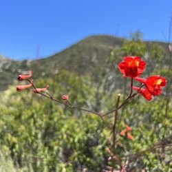
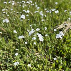
Beautiful walk in the Springtime when the heat has not come into full bloom, but the wild flowers have. My pup and I had a wonderful time. I recommend the lovely trails at Blue Sky Reserve. read more


13 years ago
2.5-3 mile dirt trail loop with some incline/decline, but not too difficult. $10 if you park in the lot, but there is street parking at the bottom of the entrance at Lake Poway Road & Espola. There are bathrooms by the parking lot, but none along the trail. Dog on leash friendly. Pretty greenery, but not much sun cover so bring enough water and wear sunblock, especially if you branch off onto Mount Woodson trail towards Potato Chip Rock. read more


I hit up this trail a few weeks ago with my four-legged, furry boy wonder. It was a very nice morning and there was still some mist in the air. The Lake Poway Trail itself is approx. 2.75 miles long and there are a lot of varying hills, so you get a solid workout. Dog-friendly trails, but do not go down by the water. I suppose that helps not only the fish and fishermen, but your doggie's health too. If you are feeling ambitious, there are a couple of trails that shoot off and you can hike Mt. Woodson or other big trails. Be prepared to pay $5 for parking if you are not a Poway resident. That is my one booooooooo to the whole experience. I would totally hit up these trails more often, but it would get pretty expensive, pretty fast. read more


12 years ago
Great trail around the lake for beginners or anybody. It's a pretty walk with dirt/gravel trails. There is about 3 or 4 different hikes you can take that lead off from the lake Poway trail including mount woodson, blue sky, etc... I've see people take their dogs, bikes, even jogger strollers (a little difficult) around this lake trail! There's a few out houses around the lake trail if worse came to worse and you had to go! But ewwww.... I'd recommend at least a bottle of water and or pack a lunch in a back pack and enjoy a picnic up over looking the beautiful lake half way through :) read more

17 years ago
This was a great hike and a great workout. The right amount of uphill and downhill terrain. I veered off course a bit and ran into Poway Campgrounds that was shrouded with thick trees and littered with park benches. It was a great place to stop and then continue onto the trail. The trail starts at the campground/park area where many people come to bbq and hold family functions. The trail takes you around the lake. Other trails are connected to the Lake Poway Trail that are rated as more difficult to hike and it also can take you down to Lake Ramona. I only gave this trail a 4 because I had to pay $5 for parking...but otherwise this trail has a beautiful scenery of the lake and the hike itself is moderately difficult. read more


11 years ago
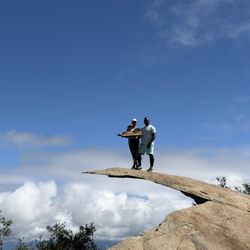
If your a serious hiker and never been to the Lake Poway Trails. Please do so. I have to say that this trail was fairly difficult. Pretty much up hill the while way. But the view its spectacular. You also can get some great selfies lol. Once to the top, mou have to take a picture on the potato chip rock. That's where you can at a fool. Nah, just playing. Don't want you to fall. Anyway, don't be intimated about the. Its Worth doing Once. -Japheth read more


13 years ago
The original plan was to go up the Potato Chip... but I got sick part of the way up. I asked my group to continue the trek but my boyfriend and I ended up doing this trail while they finished the chip. It was super mellow. Not too hilly. And you can extend your hike by 2 miles if you take a side tail. My favorite part is the view. It is beautiful to look at and really peaceful. Not too many people and it wasn't too hot. If you want to enjoy a hike this is a nice one. read more

11 years ago
I forget that this lake is here. I usually go to Miramar lake. This place need to be visited more often. Great views and hiking trails. Great place for kids to feed the ducks and it has a playground too. This is also a great place for picnics and parties. I need to remember to bring kids here more often. read more


9 years ago
10 years ago
The hike was a lot easier than I thought it would be! On a scale of 1 to 10, with 10 being the most difficult hike I've ever done (El Capitan - El Cajon Mountain Hiking Trail ~ I came with two of my friends and their two dogs. (They were little troopers throughout the entire thing!) We began our ascent at 4:45pm and the weather was perfect during this time. We were able to enjoy the sunset and feel a cool breeze throughout our hike. We paced ourselves and only took one break when we needed to hydrate the pups. We arrived at the potato chip around 6:15. Honestly, when I saw the potato chip, my face was like this -__- it's just a tiny slender piece of rock that acts as a precipice for one to take pictures on. However, if you angle your camera correctly, you can get some pretty amazing photos. We spent a good 40 minutes taking pictures of ourselves on the rock haha Make sure you have a somewhat good photographer who knows what they're doing (not me, obviously). The descent was pretty quick as it was easier to gain momentum going down rather than up. We got to our car at ~8:10PM and we found a note on our car windshield. The note said we were locked in... We drive down to the gate that we had entered, and yup we were definitely. Luckily, there was a phone number that we could call and they were able to help us get out pretty quickly. No lie, I was actually half expecting to sleep over at the park til the next morning - this was prior to my knowledge that there was number we could call. **after your first offense of staying past sunset, you will be charged a fee! Overall: *Be sure to bring enough water for yourself (and for your doggies!) *Bring a cap/hat, trekking poles, power bars *Closes at sunset (7:30PM) read more


. You WILL get locked in. - Hiking Near Me - Lake Poway, California")
10 years ago
Non poway residents: $10 to park effective 12/1. Unfortunately I'm gonna have to stop coming until it goes down. (If it does). I've been coming wkly so it adds up! The trail is a GREAT hike. This mountain is a beast! The potato chip at the top is overrated, LOL. Usually a line to get on top of it. read more

7 years ago
A lot of people confuse this trail with the woodson one, but it actually isn't. This trail forks off the main Woodson path and takes you on a loop around the entire Lake from one side of the park to the other. The trail is mostly dirt, well maintained and wide enough for bikes even. The path starts off at the eastern part of the lake and heads north following the hills up and down the mountain. You will get amazing views off the lake from all angles and be able to see the dam on the other side. There are lots of steep rises as you go up the hills then back down into the valley area. Overall the trail is a little bit more than 3 miles and is a great way to end your day after doing the Woodson climb. The area isn't shaded very good, so expect to be out in the sun a lot. read more


14 years ago
12 years ago
Page 1 of 2
More info about Lake Poway Trail
Lake Poway
Lake Poway, CA 92064
Directions
Hours
Indoor Amenities
Outdoor Amenities
Lake Poway Trail Reviews in Other Languages
Ask the Community - Lake Poway Trail
Review Highlights - Lake Poway Trail
You might also consider


Why does Yelp recommend reviews?
Lake Poway Trail - hiking - Updated July 2026
Best of Lake Poway
People found Lake Poway Trail by searching for…
Places to Take Pictures in Lake Poway, CA
Paved Walking Trails in Lake Poway, CA
Running Trails in Lake Poway, CA
Fishing Spots in Lake Poway, CA
Rock Climbing in Lake Poway, CA
Beautiful Views in Lake Poway, CA
Watch Sunset in Lake Poway, CA
Off Road Trails in Lake Poway, CA
Dirt Bike Trails in Lake Poway, CA
Easy Hiking Trails in Lake Poway, CA
Fun Things to Do at Night in Lake Poway, CA
Stroller Walk in Lake Poway, CA
Stroller Friendly Hikes in Lake Poway, CA
Dog Friendly Hiking Trails in Lake Poway, CA
Places to Walk in Lake Poway, CA
Browse Nearby
BEST of Lake Poway, California Restaurants near Lake Poway Trail
BEST of Lake Poway, California Coffee near Lake Poway Trail
BEST of Lake Poway, California Things to Do near Lake Poway Trail
BEST of Lake Poway, California Parks near Lake Poway Trail
BEST of Lake Poway, California Breakfast near Lake Poway Trail
BEST of Lake Poway, California Horseback Riding near Lake Poway Trail
BEST of Lake Poway, California Campgrounds near Lake Poway Trail
Browse Brands
Browse Articles
People who viewed Lake Poway Trail also viewed
Blue Sky Ecological Reserve
67 reviews
Black Mountain Open Space Park
56 reviews
Mira Mesa, Torrey Hills
Iron Mountain
509 reviews
Mount Woodson Trail
834 reviews
Cleveland National Forest
35 reviews
Potato Chip Rock
547 reviews
Chimney Rock Open Space Preserve
1 review
Big Laguna Trail
3 reviews
Ellie Lane Trail
7 reviews
Cedar Creek Falls
358 reviews