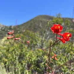
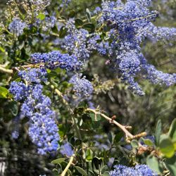
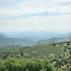
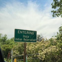
Chimney Rock Open Space Preserve Photos


You might also consider
More like Chimney Rock Open Space Preserve
Recommended Reviews - Chimney Rock Open Space Preserve
Start your review...

15 years ago
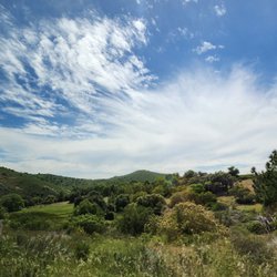
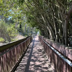
I was pleasantly surprised to find this nice scenic hike so close to home and many of the places I often visit. The hike is not a difficult one, but very convenient to get to and offers some great views of the Poway area as you get towards the summit. If you are a local to the area and looking for a quick hike, this might be a good one for you to try. read more
More info about Chimney Rock Open Space Preserve
12625 Sagecrest Dr
Poway, CA 92064
Directions
Hours
Outdoor Amenities
You might also consider


Chimney Rock Open Space Preserve - hiking - Updated July 2026
Best of Poway
People found Chimney Rock Open Space Preserve by searching for…
Trending Searches in Poway, CA
Browse Articles
Browse Nearby
BEST of Poway, California Coffee near Chimney Rock Open Space Preserve
BEST of Poway, California Restaurants near Chimney Rock Open Space Preserve
BEST of Poway, California Things to Do near Chimney Rock Open Space Preserve
BEST of Poway, California Breakfast near Chimney Rock Open Space Preserve
BEST of Poway, California Walking Trails near Chimney Rock Open Space Preserve
BEST of Poway, California Parks near Chimney Rock Open Space Preserve
BEST of Poway, California Hot Springs near Chimney Rock Open Space Preserve
BEST of Poway, California Campgrounds near Chimney Rock Open Space Preserve
BEST of Poway, California Motel near Chimney Rock Open Space Preserve
Browse Brands
Related Searches in Poway, CA
Affordable Kayak Rental Services in Poway, California
Best Fishing Locations and Guides in Poway, California
Best Places for Horseback Riding in Poway, California
Best Waterfalls and Swimming Holes in Poway, California
Check Out Off Road Trails in Poway, California
Discover Dog Friendly Trails to Explore in Poway, California
Discover Scenic Mountain Bike Trails Near Poway, California
Discover Walking Parks in Poway, California Near You
Discover a Hiking Trail in Poway, California
Discover the Best Night Hike Trails in Poway, California
Discover the Best Running Track in Poway, California
Dog-Friendly Hikes With Dogs in Poway, California
Enjoy Camping Adventures Around Poway, California
Enjoy Exciting Mountain Biking Adventures in Poway, California
Enjoy Kayaking Adventures in Poway, California
Enjoy Tent Camping Spots Around Poway, California
Enjoy a Beautiful Waterfall Hike in Poway, California
Enjoy a Peaceful Nature Walk in Poway, California
Enjoy the Best Picnic Spots and Ideas in Poway, California
Enjoy the Best Walking Path in Poway, California
Enjoy the Best Walking Trails in Poway, California
Exciting Cliff Jumping Spots in Poway, California
Explore Beautiful Parks and Green Spaces in Poway, California
Explore Easy Hikes Perfect for All in Poway, California
Explore Fun Activities to Do in Poway, California
Explore Popular Campgrounds Near Poway, California
Explore the Best Beach Spots in Poway, California
Explore the Best Trail Options in Poway, California
Family Friendly Hiking With Kids in Poway, California
Find Beautiful Views in Poway, California
Find Popular Ziplining Spots Around Poway, California
Find the Best Parks for Picnics in Poway, California
Find the Best Scenic View Locations in Poway, California
Great Places to Walk in Poway, California
Hike the Popular Waterfall Trail in Poway, California
Hiking Trails With Waterfalls in Poway, California
Off Leash Dog Hiking Trails in Poway, California
Plan a Scenic Drive Route Near Poway, California
Popular Outdoor Activities to Try in Poway, California
Popular Picnic Spots to Visit in Poway, California
Safe River Swimming Areas in Poway, California
Safe and Fun Parks for Kids in Poway, California
Top Climbing Spots and Gyms in Poway, California
Top Paddleboarding Activities in Poway, California
Top Places for Snorkeling in Poway, California
Top Running Trails to Explore in Poway, California
Top Swimming Lakes to Enjoy in Poway, California
Top Swimming Spots and Pools in Poway, California
People who viewed Chimney Rock Open Space Preserve also viewed
Twin Peaks
13 reviews
Battle Mountain
11 reviews
Rancho Bernardo
Goodan Ranch and Sycamore Canyon Open Space
12 reviews
San Dieguito River Park
27 reviews
Rancho Bernardo
Canyonside Community Park
12 reviews
Torrey Hills
Ellie Lane Trail
7 reviews
Ramona Grasslands Preserve
20 reviews
Miramar Lakeview Park
11 reviews
Scripps Ranch
Big Laguna Trail
3 reviews
Piedras Pintadas Interpretive Trail
7 reviews
Rancho Bernardo