Twin Peaks Photos


You might also consider
More like Twin Peaks
Recommended Reviews - Twin Peaks
Start your review...

Reviews With Photos

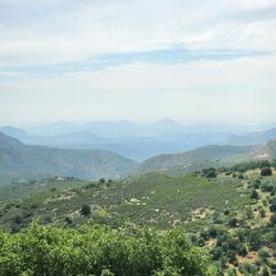
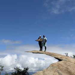
Since SD officials have closed all the city owned beaches, parks, and trails, I ventured farther away to get in some brief exercise before the next round of rain. That led me to this short hike in Poway which was less than a two mile round trip. The trailhead was at a neighborhood park where some people had gathered for a birthday party under a gazebo (read: not social/physical distancing themselves). You could see a couple of small peaks in the distance which was probably how this trail got its name. The path started wide but quickly narrowed on the clockwise loop to the top. A park worker must have used a weed whacker recently as I noticed a lot of brush and growth had been cut and pushed aside. The climb was about a 600 ft change in elevation. At the summit, there were two distinct sets of rock outcroppings which served as the "twin peaks." The views of the surrounding communities and distant mountains were lovely. The initial descent along the eastern loop was a different story. Whoever was clearing the path had either run out of fuel for their equipment or was not getting paid to finish the job. The trail was really unclear at several points so it was a good thing I had a GPS signal to follow the map on a hiking application. I don't enjoy hiking when it becomes a "choose your own adventure" scenario, and you have to backtrack when hitting a dead end. The ground was muddier on this part of the trek too. Gullies where the water had been flowing downhill after the recent batches of rainfall were prominent. I encountered a couple of parties going in the opposite direction so they were using this portion for a counterclockwise ascent. I finished the circuit in just under an hour. I would rate the hike as moderate in difficulty with a few spots being hard because of the tricky footing and overgrowth of weeds.

Short decent hike, but the signs need to be fixed to avoid wrong paths taken. It's super rocky, good uphills, and nice breeze too. Dog and Kid friendly. I suggest hiking boots for sure cause some of the dirt roads are cracked and if you feel like climbing up the rocks. I believe this will help out too for that grip factor. If you climb up some rocks look for #TeamBubs in teal & yellow gold crayola. Good Luck!!

Great moderate hike! There are several trails to choose from, but the one we did was just over 3 miles with over 800 ft of elevation gain. The trail is well maintained and rewards you with a beautiful panoramic view of Poway. read more


3 years ago
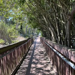
Short and sweet out-and-back trail. ~1.9 miles total, can finish in about an hour. Start in Silverset Park where there's a nice parking lot, a bathroom and a lot of families walking around. The hike itself is very quiet, I was expecting bigger crowds on a Sunday afternoon with beautiful weather but only ran into 2 solo hikers the entire trail. This could be a pro or a con depending on if you're seeking solitude or have some concerns about safety (e.g. a female solo hiker), but the area itself feels extremely peaceful and safe and embedded in a lovely suburban neighborhood. I also had cell service the whole time on this trail too which was nice. Gets steeper closer to the top and might have to climb over a good number of rocks (some of which are a bit loose) but nothing that you can't handle with a good pair of hiking shoes and a bit of caution. Agree with the other posted reviews that there's a network of trails that is not super well labeled and the signs are not helpful. Still, you can see the summit from the trail pretty much the entire time and that helped me orient myself, just choose the path leading in the direction of that summit. Great workout, views at the top are beautiful and completely worth it! read more


2 years ago
Not very well marked , great views from the top of the trail, although be aware of many trails that lead to the peak read more
Since SD officials have closed all the city owned beaches, parks, and trails, I ventured farther away to get in some brief exercise before the next round of rain. That led me to this short hike in Poway which was less than a two mile round trip. The trailhead was at a neighborhood park where some people had gathered for a birthday party under a gazebo (read: not social/physical distancing themselves). You could see a couple of small peaks in the distance which was probably how this trail got its name. The path started wide but quickly narrowed on the clockwise loop to the top. A park worker must have used a weed whacker recently as I noticed a lot of brush and growth had been cut and pushed aside. The climb was about a 600 ft change in elevation. At the summit, there were two distinct sets of rock outcroppings which served as the "twin peaks." The views of the surrounding communities and distant mountains were lovely. The initial descent along the eastern loop was a different story. Whoever was clearing the path had either run out of fuel for their equipment or was not getting paid to finish the job. The trail was really unclear at several points so it was a good thing I had a GPS signal to follow the map on a hiking application. I don't enjoy hiking when it becomes a "choose your own adventure" scenario, and you have to backtrack when hitting a dead end. The ground was muddier on this part of the trek too. Gullies where the water had been flowing downhill after the recent batches of rainfall were prominent. I encountered a couple of parties going in the opposite direction so they were using this portion for a counterclockwise ascent. I finished the circuit in just under an hour. I would rate the hike as moderate in difficulty with a few spots being hard because of the tricky footing and overgrowth of weeds. read more


 - Hiking Near Me - Poway, California")


3 years ago
Short decent hike, but the signs need to be fixed to avoid wrong paths taken. It's super rocky, good uphills, and nice breeze too. Dog and Kid friendly. I suggest hiking boots for sure cause some of the dirt roads are cracked and if you feel like climbing up the rocks. I believe this will help out too for that grip factor. If you climb up some rocks look for #TeamBubs in teal & yellow gold crayola. Good Luck!! read more


12 years ago
Located near residential homes, Twin Peaks can be accessed through Silverset Park. The trail itself, was hard to follow. There were many different trails to the side and the signs didn't help. I found the peaks just following one of the small trails. The trails have varying steep hills and loose gravel. On my way up the peaks, I didn't know which trails to follow since there were so many small trails. So I ended up going on one of the trails to the right of the peaks, which probably was one of the harder ones since there were so many loose rocks and steep inclines. The view from the top is nice though, especially with the breeze and sunshine. I saw a group of women that came from the left side of the peaks and so I took that trail back down. That trail ended up being way easier to follow and now I know which trail to use to go up now. It took me about 1 hr and 15 minutes including the times I got lost or took the wrong trail and had to go back. Long story short: nice relatively quick hike with a maze of trails and steep gravely inclines. read more

6 years ago
13 years ago
13 years ago
More info about Twin Peaks
Shadowline St
Poway, CA 92064
Directions
Hours
Indoor Amenities
Outdoor Amenities
Ask the Community - Twin Peaks
You might also consider


Twin Peaks - hiking - Updated June 2026
Best of Poway
People found Twin Peaks by searching for…
Beautiful Views in Poway, California
Hiking Trails in Poway, California
Photo Spots in Poway, California
Places to Walk in Poway, California
Off Road Trails in Poway, California
Walking Trails in Poway, California
Running Trails in Poway, California
Hiking With Kids in Poway, California
View Points in Poway, California
Dog Friendly Hiking Trails in Poway, California
Hiking Club in Poway, California
Scenic View in Poway, California
Waterfalls in Poway, California
Parks for Kids in Poway, California
Night View in Poway, California
Bike Paths in Poway, California
Dog Friendly Beaches in Poway, California
Free Things to Do in Poway, California
Trending Searches in Poway, CA
Bait And Tackle Shop near Twin Peaks
Black Owned Nail Salons near Twin Peaks
Dog Friendly Trails near Twin Peaks
Jet Ski Rental near Twin Peaks
Outdoor Activities near Twin Peaks
Pick Your Own Farms near Twin Peaks
Places To Walk Around near Twin Peaks
River Swimming near Twin Peaks
Scenic Night View near Twin Peaks
Scenic Overlook near Twin Peaks
Secluded Spots near Twin Peaks
Strawberry Picking near Twin Peaks
Swimming Holes near Twin Peaks
Swimming Lakes near Twin Peaks
Browse Articles
Browse Nearby
BEST of Poway, California Coffee near Twin Peaks
BEST of Poway, California Restaurants near Twin Peaks
BEST of Poway, California Things to Do near Twin Peaks
BEST of Poway, California Breakfast near Twin Peaks
BEST of Poway, California Walking Trails near Twin Peaks
BEST of Poway, California Parks near Twin Peaks
BEST of Poway, California Hot Springs near Twin Peaks
Browse Brands
Related Searches in Poway, CA
Affordable Kayak Rental Services in Poway, California
Best Fishing Locations and Guides in Poway, California
Best Places for Horseback Riding in Poway, California
Best Waterfalls and Swimming Holes in Poway, California
Check Out Off Road Trails in Poway, California
Discover Dog Friendly Trails to Explore in Poway, California
Discover Scenic Mountain Bike Trails Near Poway, California
Discover Walking Parks in Poway, California Near You
Discover a Hiking Trail in Poway, California
Discover the Best Night Hike Trails in Poway, California
Discover the Best Running Track in Poway, California
Dog-Friendly Hikes With Dogs in Poway, California
Enjoy Camping Adventures Around Poway, California
Enjoy Exciting Mountain Biking Adventures in Poway, California
Enjoy Kayaking Adventures in Poway, California
Enjoy Tent Camping Spots Around Poway, California
Enjoy a Beautiful Waterfall Hike in Poway, California
Enjoy a Peaceful Nature Walk in Poway, California
Enjoy the Best Picnic Spots and Ideas in Poway, California
Enjoy the Best Walking Path in Poway, California
Enjoy the Best Walking Trails in Poway, California
Exciting Cliff Jumping Spots in Poway, California
Explore Beautiful Parks and Green Spaces in Poway, California
Explore Easy Hikes Perfect for All in Poway, California
Explore Fun Activities to Do in Poway, California
Explore Popular Campgrounds Near Poway, California
Explore the Best Beach Spots in Poway, California
Explore the Best Trail Options in Poway, California
Family Friendly Hiking With Kids in Poway, California
Find Beautiful Views in Poway, California
Find Popular Ziplining Spots Around Poway, California
Find the Best Parks for Picnics in Poway, California
Find the Best Scenic View Locations in Poway, California
Great Places to Walk in Poway, California
Hike the Popular Waterfall Trail in Poway, California
Hiking Trails With Waterfalls in Poway, California
Off Leash Dog Hiking Trails in Poway, California
Plan a Scenic Drive Route Near Poway, California
Popular Outdoor Activities to Try in Poway, California
Popular Picnic Spots to Visit in Poway, California
Safe River Swimming Areas in Poway, California
Safe and Fun Parks for Kids in Poway, California
Top Climbing Spots and Gyms in Poway, California
Top Paddleboarding Activities in Poway, California
Top Places for Snorkeling in Poway, California
Top Running Trails to Explore in Poway, California
Top Swimming Lakes to Enjoy in Poway, California
Top Swimming Spots and Pools in Poway, California
People who viewed Twin Peaks also viewed
Blue Sky Ecological Reserve
67 reviews
Black Mountain Open Space Park
56 reviews
Mira Mesa, Torrey Hills
Chimney Rock Open Space Preserve
1 review
Iron Mountain
509 reviews
Mount Woodson Trail
834 reviews
Ellie Lane Trail
7 reviews
Carmel Mountain Preserve
2 reviews
Potato Chip Rock
547 reviews
Lopez Canyon
4 reviews
Sorrento Valley
Rose Canyon Bicycle Path
10 reviews