Potato Chip Rock Photos


You might also consider
More like Potato Chip Rock
Recommended Reviews - Potato Chip Rock
Start your review...

Reviews With Photos


This is a greaat hike; unfortunately, I didn't make it up to the talked about "Potato Chip Rock". It was somewhat busy but still peaceful. I was taking my time...since at certain points were a bit challenging for me since I'm not a pro at hiking especially this advanced trail. Overall, I loved the beautiful scenic views and enjoyed being in nature.

A moderate hike with great views both on the way up and at the top. We took the back route, which is mostly paved. The hike was about 4 miles round trip with roughly 1,200 feet of elevation gain to reach Potato Chip Rock. It's a steady incline for about 2 miles to the rock, making it challenging but manageable. There was a bit of a wait to take photos on the rock. I didn't take one myself, but it's definitely a great photo spot and worth the hike for the views alone.

Hiked via the Mt Woodson trail and it was absolutely lovely. We've had such a mild winter this year that it was a perfect hike to this scenic spot in January. The trail was easy to traverse. Once up to the rock, there was a line and I think we waited 30 minutes for our turn. It was an amazing experience to see everyone was so excited to get their pictures taken. There is a small gap that you need to jump over to get to the potato chip rock and people were very nice and kind to assist other folks on and off the rock. I absolutely love seeing this. You will need to come with someone or in a group so you have a photographer willing to wait and snap your picture. I did all the poses I want but was also considerate of all the folks waiting. This is the best photo op ever. I love all the pics! It's such an amazing experience that I hope everyone interested gets a chance to do. Parking is via street. Be careful, we saw police hiding and waiting to ticket speeders. Please come and visit to create your own experience.


Super fun hike! It is mostly gravel, so you'll have to have boots or wear shoes accordingly. It can get warm, so I recommend going in the early morning. There's a couple of different trails you can go, but I prefer the easier but longer trail that rounds the lake, which is so beautiful as the sun is coming up. Bring LOTS of water or hydration packs, as it will get hot the longer you're out for - and as usual, there's no place to stop aside from trail bends or the very occasional bench. Don't forget your sunscreen and food, or any first aid kit material you may want to bring with you. Better over than under prepared. There's lots of other people, but the earliest you go, the less busy it is to get your obligatory photo off of the edge of the chip.

Pretty difficult 8 miles but we made it with a smile! (My husband has a prosthetic and was able to scramble up the hike and the rock for the pics). However our pictures sucked -- do not zoom in! Crop later. ... can't really see the scope of it all So now we get to go back! Ya gotta get the pic! The only reason for climbing up there... I've been in better shape and it was grueling at times but I WILL GO BACK!

I was in Temecula for a wedding so had planned a side trip to tackle this iconic hike on a Friday in October. Unlike the rolling hills of the San Jose area, the hills in this area are full of boulders, it reminded me of the Flintstones. Bonus points for me - I saw one rock that looks like Half Dome. We hiked the shorter route (4 miles) from Cal Fire Station on Highway 67. We started at 9am, the trail was partially shaded from the sun being on the other side of the mountain. There were also some gentle breezes on this day. I enjoyed the sprawling views of the valley with backgrounds of different mountain ranges in front of each other; I think the views of the various layers of mountains are so pretty, I find it therapeutic to just stare at it. I was expecting a line of people waiting for photo shoots on the Chip Rock but there was no wait on a Friday morning. This was great cuz I made a slow crawl to the top of the ledge. We met a group of 3 people from Sweden who helped us take pictures. On the hike down the hill, we met a guy training for an ultra marathon by running 6X up and down this hill (6x4 miles out and back). I felt very accomplished by completing this hike.

One of my favorite hikes ever. It is 4 miles in and out. It is at an 8 degree incline 95% of the way so it's an amazing workout for your legs! The views are incredible along the way and at the top! We started at 6pm and made it by 7pm in time for the sunset! It was breathtaking. If i could change anything, I would've started at 530pm or 545pm to have a little more time enjoying the sunset. Being water. The trail is paved so it's well marked and good for your feet. I will definitely go again!

I love this hike ! It's challenging, steep all the way up and then steep decline. Parking is real easy at poway lake, and there may or may not be a cost to park there. Hike is about 7 miles give or take and make SURE you bring water sunscreen and comfy hiking shoes. Lots of flora and fauna. I've seen rattlers and gopher snakes, spider wasps here and there and a wide variety or lizards. This area is considered mountain lion territory as well so be cautious. The view is incredible and it is quiet in the middle of the week and packed holidays and weekends. One of my favorites ! Definitely recommend !

To get here you have to hike here, fyi the hike here was a bit difficult as I believe we took the long route according to reading other's reviews on taking a short way, which we didn't take haha We got there on an early Saturday morning which was perfect to beat the crowds, parking wasn't difficult to find either for that reason. I definitely would do this hike again it's fun and you get a good workout out of it. I was scared at first to go on the rock but made it and just hung out there until my picture was taken by my friends. It really does look like a potato chip!

Can't believe I never wrote a review for this one! It's been over a year since I hiked Potato Chip Rock and I still remember it clear as day! Went with a group 4 deep when covid was still very much poppin', and all of the outdoorsy adventures was the thing to do. I have never, ever been a morning person, but a lot of my friends are and whenever we hike, they always insist on going early. Personally, I'd rather go in the late afternoon into the evening when it's cooler. We arrived around 830am and got going around 9. I want to say there's at least 2 ways to get to the Chip, but don't quote me on that. Whatever route we took was pretty fast imo, although it was A LOT of steep hills and turning corners. I do remember that I liked the paved road. It wasn't rocky until we got near the end. Service trucks take that same road up and sometimes you may have to move to the side to let them pass. There's a lot of good spots for scenic photo opps as you can see...and if you "gotta go" at any time during your hike, you won't have a problem finding a little secret space to handle your biz (bring a pack of wipes, lol). You might have to wait until people pass until you're in the clear, so make sure you go with a group who has your back! I think it took us about an hour and a half to get to the Chip, and when we got there around 10:30, we were glad to see the line wasn't super long. Depending on what time you get there, you could be waiting a good while before you're actually standing on it. Getting ON the actual Potato Chip itself is a bit tricky, but you'll find a way, lol. We got a good amount of pics and the people behind us kept their cool while they waited for us to finish snapping away. Once we finally did finish, getting down was a bit nerve wracking (especially if you're afraid of heights), but this is where your trusty group will come in handy! I did the half climb down, half jump down and made it without a hitch. Overall this is a quick hike that leaves you feeling accomplished and invigorated. Be sure to bring a lot of water! Don't skimp on it in the hotter months! I'd also recommend a few protein or snack bars if you're prone to getting lightheaded or dizzy. Aaaaaaand of course, don't forget to slather on your sunscreen, bring a hat and shades to make your hike as comfortable as possible. One of those towels that stays cool around your neck would be a great thing to have, along with comfortable hiking boots or shoes. Be safe, alert and watch your steps (there are some rocky parts) going up and back down. Take breaks when you need to and keep going 'til you make it on that Chip! You'll be so glad when you do! Have fun!!

5 months ago
Hiking up to Potato Chip Rock was absolutely worth every step. The trail is challenging but rewarding, and once you reach the top, the views are incredible -- sweeping mountains, open skies, and that famous thin rock formation that makes for epic photos. The climb definitely gets your heart pumping, especially in the steeper sections, but the path is well traveled and clearly marked. Going early in the morning helped beat both the heat and the crowds, which I'd highly recommend. At the summit, everyone's in a great mood -- hikers cheering each other on, people taking turns snapping pictures, and that shared "we made it" feeling. It's one of those classic San Diego outdoor experiences that really sticks with you. If you like scenic hikes with a fun payoff at the end, this is a must-do. Tough, beautiful, and iconic -- I'd hike it again in a second. read more


Finally visited the famous Potato Chip Rock! Too bad it was all cloudy on top so couldn't admire the 360 view. Someone left a sign with name and elevation (great for photo opp!). Still surprised by how strong it is considering it looks dangerously thin. Tip: start from Highway 67 side (park along road). Steep but much shorter than Lake Poway route. Took 1hr 15 min up with breaks to catch breath, and 45 min down. Lots cool HUGE boulders along way. Cell towers look so sublime in clouds. read more


This is a greaat hike; unfortunately, I didn't make it up to the talked about "Potato Chip Rock". It was somewhat busy but still peaceful. I was taking my time...since at certain points were a bit challenging for me since I'm not a pro at hiking especially this advanced trail. Overall, I loved the beautiful scenic views and enjoyed being in nature. read more


A moderate hike with great views both on the way up and at the top. We took the back route, which is mostly paved. The hike was about 4 miles round trip with roughly 1,200 feet of elevation gain to reach Potato Chip Rock. It's a steady incline for about 2 miles to the rock, making it challenging but manageable. There was a bit of a wait to take photos on the rock. I didn't take one myself, but it's definitely a great photo spot and worth the hike for the views alone. read more


2 months ago
Hiked via the Mt Woodson trail and it was absolutely lovely. We've had such a mild winter this year that it was a perfect hike to this scenic spot in January. The trail was easy to traverse. Once up to the rock, there was a line and I think we waited 30 minutes for our turn. It was an amazing experience to see everyone was so excited to get their pictures taken. There is a small gap that you need to jump over to get to the potato chip rock and people were very nice and kind to assist other folks on and off the rock. I absolutely love seeing this. You will need to come with someone or in a group so you have a photographer willing to wait and snap your picture. I did all the poses I want but was also considerate of all the folks waiting. This is the best photo op ever. I love all the pics! It's such an amazing experience that I hope everyone interested gets a chance to do. Parking is via street. Be careful, we saw police hiding and waiting to ticket speeders. Please come and visit to create your own experience. read more


9 months ago
Love this trail, I only do this hike early in the morning to catch the sunrise, which has the best view ever! read more


Super fun hike! It is mostly gravel, so you'll have to have boots or wear shoes accordingly. It can get warm, so I recommend going in the early morning. There's a couple of different trails you can go, but I prefer the easier but longer trail that rounds the lake, which is so beautiful as the sun is coming up. Bring LOTS of water or hydration packs, as it will get hot the longer you're out for - and as usual, there's no place to stop aside from trail bends or the very occasional bench. Don't forget your sunscreen and food, or any first aid kit material you may want to bring with you. Better over than under prepared. There's lots of other people, but the earliest you go, the less busy it is to get your obligatory photo off of the edge of the chip. read more

Pretty difficult 8 miles but we made it with a smile! (My husband has a prosthetic and was able to scramble up the hike and the rock for the pics). However our pictures sucked -- do not zoom in! Crop later. ... can't really see the scope of it all So now we get to go back! Ya gotta get the pic! The only reason for climbing up there... I've been in better shape and it was grueling at times but I WILL GO BACK! read more


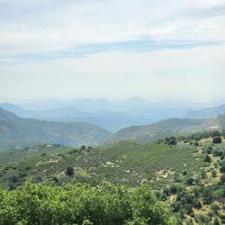
I was in Temecula for a wedding so had planned a side trip to tackle this iconic hike on a Friday in October. Unlike the rolling hills of the San Jose area, the hills in this area are full of boulders, it reminded me of the Flintstones. Bonus points for me - I saw one rock that looks like Half Dome. We hiked the shorter route (4 miles) from Cal Fire Station on Highway 67. We started at 9am, the trail was partially shaded from the sun being on the other side of the mountain. There were also some gentle breezes on this day. I enjoyed the sprawling views of the valley with backgrounds of different mountain ranges in front of each other; I think the views of the various layers of mountains are so pretty, I find it therapeutic to just stare at it. I was expecting a line of people waiting for photo shoots on the Chip Rock but there was no wait on a Friday morning. This was great cuz I made a slow crawl to the top of the ledge. We met a group of 3 people from Sweden who helped us take pictures. On the hike down the hill, we met a guy training for an ultra marathon by running 6X up and down this hill (6x4 miles out and back). I felt very accomplished by completing this hike. read more


One of my favorite hikes ever. It is 4 miles in and out. It is at an 8 degree incline 95% of the way so it's an amazing workout for your legs! The views are incredible along the way and at the top! We started at 6pm and made it by 7pm in time for the sunset! It was breathtaking. If i could change anything, I would've started at 530pm or 545pm to have a little more time enjoying the sunset. Being water. The trail is paved so it's well marked and good for your feet. I will definitely go again! read more


2 years ago
I love this hike ! It's challenging, steep all the way up and then steep decline. Parking is real easy at poway lake, and there may or may not be a cost to park there. Hike is about 7 miles give or take and make SURE you bring water sunscreen and comfy hiking shoes. Lots of flora and fauna. I've seen rattlers and gopher snakes, spider wasps here and there and a wide variety or lizards. This area is considered mountain lion territory as well so be cautious. The view is incredible and it is quiet in the middle of the week and packed holidays and weekends. One of my favorites ! Definitely recommend ! read more

1 year ago
2 years ago
3 years ago
To get here you have to hike here, fyi the hike here was a bit difficult as I believe we took the long route according to reading other's reviews on taking a short way, which we didn't take haha We got there on an early Saturday morning which was perfect to beat the crowds, parking wasn't difficult to find either for that reason. I definitely would do this hike again it's fun and you get a good workout out of it. I was scared at first to go on the rock but made it and just hung out there until my picture was taken by my friends. It really does look like a potato chip! read more


Can't believe I never wrote a review for this one! It's been over a year since I hiked Potato Chip Rock and I still remember it clear as day! Went with a group 4 deep when covid was still very much poppin', and all of the outdoorsy adventures was the thing to do. I have never, ever been a morning person, but a lot of my friends are and whenever we hike, they always insist on going early. Personally, I'd rather go in the late afternoon into the evening when it's cooler. We arrived around 830am and got going around 9. I want to say there's at least 2 ways to get to the Chip, but don't quote me on that. Whatever route we took was pretty fast imo, although it was A LOT of steep hills and turning corners. I do remember that I liked the paved road. It wasn't rocky until we got near the end. Service trucks take that same road up and sometimes you may have to move to the side to let them pass. There's a lot of good spots for scenic photo opps as you can see...and if you "gotta go" at any time during your hike, you won't have a problem finding a little secret space to handle your biz (bring a pack of wipes, lol). You might have to wait until people pass until you're in the clear, so make sure you go with a group who has your back! I think it took us about an hour and a half to get to the Chip, and when we got there around 10:30, we were glad to see the line wasn't super long. Depending on what time you get there, you could be waiting a good while before you're actually standing on it. Getting ON the actual Potato Chip itself is a bit tricky, but you'll find a way, lol. We got a good amount of pics and the people behind us kept their cool while they waited for us to finish snapping away. Once we finally did finish, getting down was a bit nerve wracking (especially if you're afraid of heights), but this is where your trusty group will come in handy! I did the half climb down, half jump down and made it without a hitch. Overall this is a quick hike that leaves you feeling accomplished and invigorated. Be sure to bring a lot of water! Don't skimp on it in the hotter months! I'd also recommend a few protein or snack bars if you're prone to getting lightheaded or dizzy. Aaaaaaand of course, don't forget to slather on your sunscreen, bring a hat and shades to make your hike as comfortable as possible. One of those towels that stays cool around your neck would be a great thing to have, along with comfortable hiking boots or shoes. Be safe, alert and watch your steps (there are some rocky parts) going up and back down. Take breaks when you need to and keep going 'til you make it on that Chip! You'll be so glad when you do! Have fun!! read more


3 years ago
Went in 2021 and again this month. Both times were fun and rewarding! The keys for a good hike is to be well prepared with adequate amount of liquid, a pair of good hiking shoes, and hike on a comfortable weekday. It was about 60F on a February Friday afternoon. Parking at Lake Poway was free on weekdays. Tail wasn't crowded. Line to take pictures at the potato chip rock was short. We waited probably 5 mins. But do be careful jumping onto the rock. If you need help, ask. People up there were helpful! Great views on the top and during the hike! read more


Bucket list hike activated! This hike to Potato Chip rock is truly a memorable one. I've been wanting to hike this trail for years and I finally got my chance to last fall. Was it worth it?! Totally! I'd definitely hike this trail again in a heartbeat. There are two different ways to reach Potato Chip Rock; from Lake Poway Park via the Mount Woodson Trail or from Highway 67 via the Mount Woodson Fire Road trail. Both trails are moderately difficult, but the Mount Woodson Trail is longer (7 miles total) with a higher overall elevation gain while the Mount Woodson Fire Road Trail is shorter (4.5 miles total) with a steeper ascent and paved fire road path. I hiked the fire road trail since it was closer to drive to and the less popular trail between the two. This actually ended up working in my favor because there was virtually nobody else on this trail when I hiked it on a Friday morning. I started around 8 am and it was still pretty cool in the morning. There's minimal to no shade on either trail, so I'd highly recommend starting early or coming before sunset to avoid the heat and direct sunlight. From highway 67, you can park on the side of the road. The directions will actually take you to the Cal Fire Romana station entrance, but you can't park in there. You'll have to make a U-turn and park on the highway. From here, there's a small sign that'll say Potato Chip Rock. You'll follow that trail until you reach a paved fire road. This is Mount Woodson Road. It's just a straight shot to the top from this trail. It starts off pretty easy on a flat paved path. Soon, the path will start to pick up the pace and begin inclining until you reach Potato Chip Rock. Parts of this trail going up are very steep, but since the path is paved and you're going uphill, it's easy to keep steady footing. What's nice about this trail is that the views are absolutely gorgeous on the way up. You'll have sweeping views of both the city and valley all around you. It gets better as you reach higher ground. It's crazy because Potato Chip Rock will literally just creep up on you. If I wasn't paying attention, I might have just passed it up. In fact, I only stopped because I saw a few people standing there. And then boom, there it is! Potato Chip Rock in the distance. Not gonna lie... I was scared sh*tless while standing on that rock. Getting up there is only half the battle. It actually took me two attempts to actually stand up straight and take a proper picture on that rock. Ahh yes, my little fear of heights was definitely showing. It's a scramble to get up there and even more a scramble sliding down between huge boulders to get down, but you HAVE to get up there. Because, what's the point of hiking at the way there and NOT gettin' up on that chip?! I won't judge you if you don't do it... I mean, it is scary as sh*t. All I'm saying is, at least TRY to get up there. You'll feel so accomplished once you do. Plus, those pictures are gonna be poppin', son! The way back down can actually be just as tough if you have bad knees or bad shoes. Bring the proper gear if you need it (hiking poles; sturdy hiking boots). I've found that in my tender oldish age (BAHA!) that going downhill has become a lot more difficult for me because of my poor feet. I don't know what it is, but my feet do not do as well coming down steep hills anymore. And this is in all 6 hiking shoes that I own and with poles. Nothing seems to really work except hiking more so that they just get used to it, but I digress. This was such a fun hike and one of my favorites to do in the SD area. If you're looking for a moderately challenging hike with great views and an awesome reward at the halfway point, Potato Chip Rock is your baby. Enjoy! read more


 - Hiking Near Me - Poway, California")
3 years ago
Always a fun hike. Was nice change to hike it from the back side. Got lucky with no crowds. Maybe because all the people cause the tip of the chip to break off. The views are always lovely getting up and away from town. It was the perfect day to picnic and take a lunch break at the top. On a hot day you do need water to stay hydrated and sun block skin cancer kills people. Other than that her outside and enjoy!! read more


3 years ago
About a 2.5 mile hike if you start the hike at the highway 67 Ramona area! Pretty easy to find the hike as there are signs to guide you to the start of the trail. The hike overall is just incline throughout, so make sure to come early (to avoid direct sunlight) and bring water! Just an average walker/hiker & it was a BIT tough not going to lie. but the view made it worth it!! as for the potato chip rock, it's a bit scary to climb up the few rocks so make sure to wear proper shoes & be careful! happy to cross this hiking trail off my bucket list :-) first and last time, though. read more

I have heard about this hike for years. The photos are incredible if not heart-stopping. This trip I was determined to be a doer and no more excuses. I told our group no whining and bring plenty of water. We set off early to avoid the heat. We elected to do the back path that is a paved fire trail, steeper incline on a paved shorter path and a different view of the valley. This trail is half the length of the other path. Steep and spectacular views are perfect terms for this hike. It is a moderately difficult trail that required multiple stops, water breaks and breathe taking views. The size of the rocks are inspirational and impressive. The paved ground made it more managable when you are tired . Now to the potato chip. It is not for the faint of heart. It defies gravity and really messes with your mind. With that said, you have to get a photo on the chip. I was able to scoot onto the chip but had to be coaxed into standing, shaking knees and all. Yes, I got the photo. What a exhilarating experience and a great workout. This will not be our last hike to potato chip rock. We will definitely being dragging friends up here to share the view, the photo opportunities and a beautiful view of California's less crowded areas read more


Great workout, there is a moderate incline throughout the trail. Round trip took about 3.5 hours, you could probably make the trip in 3 but we were walking at a slower pace going up. Total of 7.3 miles. Pros - since the trail is not as popular as it was a few years back, there isn't much of a line. - cool view from the top of the city - environment is pretty well kept and clean - dogs on leash are allowed on the trail Cons - No bathrooms, there are a few portable potties along the beginning of the trail or the bathrooms at the park. - Paths become a bit narrow towards the middle of the path. - the whole trail is exposed. No shade whatsoever. - lots of rock steps to climb/walk over Tips * start early as possible! To avoid as much sun exposure and people. * bring enough water + snacks * don't forget the sun block! The sun is brutal! read more


4 years ago
Not as difficult as you may think. We went to potato chip rock via hwy 67 where the head entrance is by the fire station. Ramona station 86. There are clear signs to follow to the trail and even 2 trash cans in the beginning. Not a difficult hike but it's all uphill from the highway side. It is significantly shorter than following the main trail route. I highly recommend for the views at the top and the famous chip rock!! I came at the perfect time. Weekday around 9am and got to the top around 10? It's quick to come back down as well. Bring water though and decent hiking shoes since it's rocky and the decline could be slippery. read more


3 years ago
Easy to Moderate walk. No need for special shoes, the walkway is paved most of the way. Just comfortable running shoes will do. The grade is not steep and there is plenty of room to take brakes. 32 oz of water per person is plenty. Keep going after you reach the top. There is a small downhill bit until you reach the rock. Nice view, you'll be at the top within 1h30. Back within 2h30. read more


Potato chip is overrated. With that said, it's San Diego obligatory right of passage to have a picture on the rock. If you don't, can you truly call yourself a San Diegan?! LOL. (You and that Disneyland line of hella people) I only have one picture way back in 2011, and have been on this hike 3 other times but the line was waaaay to long, even at 8am! Good luck! Potato chip isn't Mount Woodson Summit, it's just a rock on the way to Mt Woodson Summit along Mt Woodson Trail. If you walk a little past Potato chip, you can ascend the actual Mt Woodson Summit. It's quieter and beautiful and definitely less crowded. Good photos too. 3 ways to get there: (easiest to hardest) -HWY 67/RAMONA: Back side of Mt Woodson Trail. Very steep about a 2 mile hike up (4 miles RT) to reach PC. Go early, the sun bakes you on that side. Free parking along HWY 67. Total time about 1.5-2 hours. -LAKE POWAY: Popular way up to the chip. Park at the Lake $10 for non resident. About 3.8 miles to the chip (7.6 miles round trip). This is a challenging way. It's hot, long and you'll need water and some snacks! It'll take about 3-3.5 hours. Crowded, dog friendly. -BLUE SKY RESERVE: less crowded way up. It's an extra 2 miles (extra 4 miles plus regular loop) up through the reserve then you meet on the normal trail thru Lake Poway. Free parking at the reserve! Total miles 11 RT, about 3.5-4 hours. Challenging hike if you are not really fit. Otherwise, it's very manageable with breaks and taking your time. Go early if you can, not for the picture but because it gets reallllllly hot. read more
 - Hiking Near Me - Poway, California")
$10 for parking- there is street parking available. Make this a whole day thing. Use bathroom before ascending. Port a potty only available at the very beginning of trail. Stay on Woodson trail (there are other trails mixed in- follow Woodson signs to lead you up to the CHIP). Once reaching summit head directly to the line for taking the pictures and rest there while eating your snacks and waters. Line is abt 1 hour long.... take or give. No trash bins, so pack smart. There are bees along the trail and on top - be prepared. I have a cooler in my car filled with ice cold drinks, apples, and sparkling waters etc etc. once descended and back to the car it is extremely refreshing having that cooler filled with cold treats to be enjoyed as a reward after that hot long hike! read more


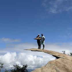
This is a review of the rock, not of the (Mt. Woodson) trail. I'm just talking rock today. First, getting onto the old potato chip rock is not necessarily easy. You either have to jump from the first rock to the chip rock or you have to ease yourself, using your arms to lower yourself, from the first rock to the chip. If you mess it up, you probably won't die, but you could get hurt. Just sayin'. Getting off is easier but also a little tricky. We slowly eased ourselves down the chip rock and that worked out ok. The chip itself is very narrow. It's stable but narrow. If you have a fear of heights (*raises hand*), well, just know before you go. At about 10:30 a.m. on a Saturday, there was about a 5 minute wait to get on the rock. Everyone mentions hour long waits. I guess it depends on when you go. Is it worth it? If you've accomplished the hike, sure. You might as well do it. Lots of friendly folks around to take a pic. This is a bit of a San Diego landmark. Kind of a strange one but there it is. read more

Potato Chip Rock is a well-known trail in the San Diego area. Everyone's hiking levels are subjective. I would categorize the trail as a moderately-advanced hike with lots of inclines and limited shade. Yaayyy! Made it to the top! Free parking on the road. High elevation is reached in NO time! Really! Gorgeous views throughout the hike. Getting to the chip requires a jump or sliding off of rocks. The app AllTrails provided excellent pre-planning insight. read more


A cool spot along the Mt. Woodson Trail to take some IG worthy pictures. There are 2 trails that lead here, the 7 mile total trail from the Lake Poway entrance or the or the 4 mile fire road trail off the 67. In the Tip section of the Mt. Woodson yelp page someone posted the actual address that you can gps to get to that part of the 67. From what I've heard they line to take a pic at Potato Chip rock can be as long as 45 minutes to 2 hours, so if you're going on a weekend try to get to the trail around or before 8am. Even though the trail doesn't seem to have a crazy elevation gain (around 1,250 total) parts of the trail can feel pretty steep. If you're a beginner level hiker this trail is do able, but make sure you bring enough water & some snacks. Parts of the trail can get pretty hot during the summer. During July when I went the temperature said it was only about 68° around 7am but it felt more like the mid 80s. read more


One of the best hikes I've ever done. It's worth driving this far. To get your photo op is the main goal anyway. Steep and not too long-distanced,you have to be here before 0700-0800. After these hours,there is an hour long wait to get to the potato chip rock for a good photo. Always bring water in a backpack for convenience. read more


2 years ago
Recommend heading out early to beat the heat and the crowds, but the photo opportunity is worth the hike alone. Took about 4 hours to complete the hike with one brand new hiker in our group. Getting on to the chip is a little challenging and we saw some groups with dogs unable to get their dogs up. read more

1 year ago
Page 1 of 14
More info about Potato Chip Rock
14644 Lake Poway Rd
Lake Poway Park
Poway, CA 92064
Directions
Hours
Indoor Amenities
Outdoor Amenities
Potato Chip Rock Reviews in Other Languages
Ask the Community - Potato Chip Rock
Is this hike stroller / infant friendly?
Not stroller friendly. If children are 7+ and have a good disposition they will hike it without complaint and several rest stops. Remember this is a mountain with elevation. There's more to the beauty than just the potato chip… Read more
Does anyone know the exact address to Ramona side?
Near Cal Fire-Paste this in google maps: 16310 CA-67
Where is the best spot for parking?
It depends which way you choose to hike. For the longer hike, park at Lake Poway park. I'm not sure where you park if you hike from Ramona.
How's the parking on the 67? I won't be towed right?
No, plenty of cars lined up along the way.
Do i need help climbing up to the potato chip rock. Can i go by myself?
You do not need help climbing up to Potato Chip Rock. Often, there is a line of about 15 people waiting their turn to walk on top of Potato Chip Rock. You need to climb up a little boulder to reach the top surface of Potato Chip Rock. It is as… Read more
What is the address for free parking?
You can park at Lake Poway parking lot and hike to potato chip rock The parking is free on weekdays… Read more
How long is the hike?
From the park entrance, depending on the hiker ability can take four hours. (it took us longer in the heat!)… Read more
Is there any bugs, mosquitoes, snakes on the trail?
Yes. We saw a huge snake about 5" long about 4 months ago. Just be careful. No mosquitoes or bugs that may harm you.
What's the address for parking?
16643 Highway 67 should get you to the area where you can see everyone parks
What time should we start this hike to avoid crowds?
Of course 6am would be ideal, when the park opens, but we began our hike around 7:30am on a Sunday and it wasn't bad. I feel like you would still wait for a pic on the rock regardless (which I did, for almost an hour), unless you get there right at… Read more
Gonna check this out. We want to go as early as possible on a weekday. How early is the parking open? Are we parking in the lake poway parking?
Park opens from sunrise to sunset
How long does it take to get to the top ? And is it hard to get to the top
Depends if you want to attempt the mountain from the front or back. The front is. Ear the lake and takes an hour or so and then back side takes about a half an hour. I also have long legs so I'm a quick hiker, times might vary
How to get to teailhead
To get to the trailhead the main route people always use is through going to the Lake Poway Entrance and then when you get to the front of the piers just follow the trails on the right and the signs will help you out.
Review Highlights - Potato Chip Rock
You might also consider


Why does Yelp recommend reviews?
22 reviews that are not currently recommended
The reviews below are not factored into the business's overall star rating.
2 years ago
3 years ago
10 years ago
10 years ago
9 years ago
7 years ago
8 years ago
11 years ago
5 years ago
5 years ago
10 years ago
10 years ago
8 years ago
6 years ago
6 years ago
9 years ago
11 years ago
10 years ago
6 years ago
Potato Chip Rock - hiking - Updated June 2026
Best of Poway
People found Potato Chip Rock by searching for…
Things to Do in Poway, California
Swimming Lakes in Poway, California
Scenic Drives in Poway, California
Waterfall Hike in Poway, California
Beautiful Views in Poway, California
Tourist Attractions in Poway, California
Attractions in Poway, California
Swimming Holes in Poway, California
Star Gazing in Poway, California
Rock Climbing in Poway, California
Easy Hikes in Poway, California
Night Hike in Poway, California
Hiking Trails in Poway, California
Hiking Club in Poway, California
Sunrise View in Poway, California
Watch Sunset in Poway, California
Things to Do on a Sunday in Poway, California
Lookout Points in Poway, California
Hiking With Kids in Poway, California
Trending Searches in Poway, CA
Bait And Tackle Shop near Potato Chip Rock
Black Owned Nail Salons near Potato Chip Rock
Boat Rental near Potato Chip Rock
Cliff Jumping near Potato Chip Rock
Day Trips near Potato Chip Rock
Dog Friendly Trails near Potato Chip Rock
Fishing Spots near Potato Chip Rock
Jet Ski Rental near Potato Chip Rock
Kayak Rental near Potato Chip Rock
Lakes & Ponds near Potato Chip Rock
Outdoor Activities near Potato Chip Rock
Pick Your Own Farms near Potato Chip Rock
Places To Walk Around near Potato Chip Rock
Public Shower near Potato Chip Rock
River Swimming near Potato Chip Rock
Rock Quarry near Potato Chip Rock
Scenic Night View near Potato Chip Rock
Scenic Overlook near Potato Chip Rock
Secluded Spots near Potato Chip Rock
Soccer Store near Potato Chip Rock
Splash Pad near Potato Chip Rock
Strawberry Picking near Potato Chip Rock
Sunrise View near Potato Chip Rock
Swimming Holes near Potato Chip Rock
Swimming Lakes near Potato Chip Rock
Swimming Pools near Potato Chip Rock
Watch Sunset near Potato Chip Rock
Browse Articles
Browse Nearby
Browse Brands
Related Searches in Poway, CA
Affordable Kayak Rental Services in Poway, California
Best Fishing Locations and Guides in Poway, California
Best Places for Horseback Riding in Poway, California
Best Waterfalls and Swimming Holes in Poway, California
Check Out Off Road Trails in Poway, California
Discover Dog Friendly Trails to Explore in Poway, California
Discover Scenic Mountain Bike Trails Near Poway, California
Discover Walking Parks in Poway, California Near You
Discover a Hiking Trail in Poway, California
Discover the Best Night Hike Trails in Poway, California
Discover the Best Running Track in Poway, California
Dog-Friendly Hikes With Dogs in Poway, California
Enjoy Camping Adventures Around Poway, California
Enjoy Exciting Mountain Biking Adventures in Poway, California
Enjoy Kayaking Adventures in Poway, California
Enjoy Tent Camping Spots Around Poway, California
Enjoy a Beautiful Waterfall Hike in Poway, California
Enjoy a Peaceful Nature Walk in Poway, California
Enjoy the Best Picnic Spots and Ideas in Poway, California
Enjoy the Best Walking Path in Poway, California
Enjoy the Best Walking Trails in Poway, California
Exciting Cliff Jumping Spots in Poway, California
Explore Beautiful Parks and Green Spaces in Poway, California
Explore Easy Hikes Perfect for All in Poway, California
Explore Fun Activities to Do in Poway, California
Explore Popular Campgrounds Near Poway, California
Explore the Best Beach Spots in Poway, California
Explore the Best Trail Options in Poway, California
Family Friendly Hiking With Kids in Poway, California
Find Beautiful Views in Poway, California
Find Popular Ziplining Spots Around Poway, California
Find the Best Parks for Picnics in Poway, California
Find the Best Scenic View Locations in Poway, California
Great Places to Walk in Poway, California
Hike the Popular Waterfall Trail in Poway, California
Hiking Trails With Waterfalls in Poway, California
Off Leash Dog Hiking Trails in Poway, California
Plan a Scenic Drive Route Near Poway, California
Popular Outdoor Activities to Try in Poway, California
Popular Picnic Spots to Visit in Poway, California
Safe River Swimming Areas in Poway, California
Safe and Fun Parks for Kids in Poway, California
Top Climbing Spots and Gyms in Poway, California
Top Paddleboarding Activities in Poway, California
Top Places for Snorkeling in Poway, California
Top Running Trails to Explore in Poway, California
Top Swimming Lakes to Enjoy in Poway, California
Top Swimming Spots and Pools in Poway, California
People who viewed Potato Chip Rock also viewed
Stonewall Peak Trail
100 reviews
Los Penasquitos Canyon Preserve
395 reviews
Mira Mesa, Torrey Hills
Lake Poway Trail
64 reviews
Maple Canyon Trail
20 reviews
Banker's Hill
Devil's Jumpoff
4 reviews
Cuyamaca Peak
32 reviews
Old Mission Dam Trail
13 reviews
San Dieguito River Park
27 reviews
Rancho Bernardo
Annie's Canyon Trail
375 reviews
Pacific Crest Trail At Penny Pines
22 reviews