Bernardo Mountain Photos


You might also consider
More like Bernardo Mountain
Recommended Reviews - Bernardo Mountain
Start your review...

Reviews With Photos

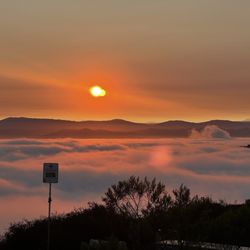
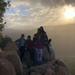
I hiked up the mountain! Yay me! I come to the San Dieguito River Park area often to get outdoors for a nice hike but I always try to stick with the easy flat areas. I've been wanting to try hiking Bernardo Mountain but i'm always more comfortable trying a new hike if I bring someone with me. My cousin has been wanting to hike up a big mountain so I thought Bernardo Mountain was nice to try. The hike is around under 8 miles out and back but my stupid new fitbit tracked some weird areas so it looked like we hiked 11 miles. Lol. The majority is flat for about 2 miles from the Sunset Dr trailhead. Go past the Felicita Creek then you should see the trailhead for Bernardo Mountain. The hike to the top is around 1.9 miles. I am not a person that likes inclines since I am not used to it. I had to catch my breath a few times. There were some steep areas and some flat areas. It is rocky when you get to the Bernardo Mountain trail so you need to make sure you have some good shoes. We saw plenty of people with hiking sticks. Some people mentioned that the sticks helped them a lot but you can do this hike without it. One of the steep areas we had to slide down since it's scary when you go back down! The view from the top is amazing. Lake Hodges is so beautiful! You can see so much up there. Definitely worth it to take this hike. There was a little sign in book in a plastic container. Someone must have removed the ammo box. Bernardo Mountain is a good moderate hike. I am overweight and out of shape but I was able to complete the longest hike of my life. It's not easy but it made me push myself to get to the top. So worth it! I am so happy I did this. :)

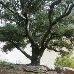
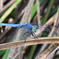
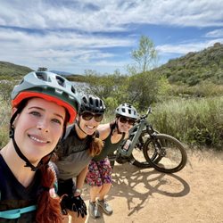
Enjoyable Hike This was a moderate hike with beautiful scenery near Rancho Bernardo/Escondido. This hike started with a flat path and gradually inclined to a very steep last half mile. Lots of wildlife, we saw roadrunners, lizards and a variety of birds. Tons of hummingbirds once we reached the top. At the top of the trail you have a gorgeous view of Lake Hodges. Awesome panoramic views of North County San Diego. Not many trees - remember your sunscreen and water. On the trail be mindful of mountain bikers, horseback riding and joggers. Have fun!!!

I saw the Bernardo Mountain trailhead sign while hiking along the Coast-to-Crest Trail in Escondido. Bernardo Mountain is listed at 1150 ft. in elevation and about a 1.9 mile hike to the top. It's probably not something to hike on the spur of the moment. The trail itself has various hiking patters but there are switchbacks, dirt trails, rock trails, and some steep sections. The top consists of small bolder like rocks and a good vantage point for panoramic pictures. Going down is a breeze, but remember which trail you came up on. I almost missed my trail turn off half way down. - If it's hot, there's no relief on the way up. Hat + lots of water + sunscreen. - Annoying swarming wasps at the top of the mountain. - Ammo box with a log book, a book of Mormon, various other items. - Not recommended for small kids. - 92 outside and still made it up. (Needed a water break a few times though).

It's been a while but I came back to this mtn since I needed something local. I enjoyed it more this time. Not a ton of ppl. I had deleted all trails off my phone so when I got to the 2 spots with no signs, I got nervous. I hung left and it ended up being the right choice. Watch out for mtn bikers! If you are a mtn biker, please have a bell. These bikers come up so fast that you don't hear them till they're too close to stop easily. My dog almost got ran over by one I didn't hear. The guy almost fell trying not to hit my dog who was on leash. Cool sighting today... saw deer! Shocked to see them so close to civilization. Literally right off the freeway part.

I have hiked around Lake Hodges a few times last year, saw the sign of Bernardo Mountain Summit but didn't go that way. After reading some reviews here, today I decided to give it a shot. Because I knew how to get there so driving isn't an issue. I'd rate this trail between easy to moderate. Some areas do get steep and rocky that make it difficult to hike, but if you have walking sticks like me, it will make a lot easier and safer when you come down. Round trip is about 10km from the pedestrian bridge to the summit. Let's talk about the view, when you get to the top, the view of the lake is spectacular! I took a panoramic one and you will know what I am talking about. Safety: well, I wasn't worried about the rattle snakes because they are probably still hibernating. Unlike Double Peak, this one is kind of quiet and isolated. Maybe not a lot of people know about this trail, I just ran into a few hikers today. Would I come back? Yes, but maybe next time with a buddy!

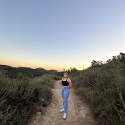
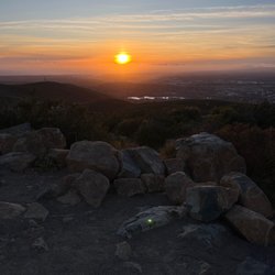
This review pertains to the entire hike from San Dieguito River Park off Via Rancho Parkway to the top of Bernardo Mountain and back. Total distance was just under 8 miles, and bear in mind I did this in mid-December when the weather is cool even at midday. For starters: the San Dieguito River Park Rangers are pretty awesome. I got into a long conversation with Brian, a Ranger before I set out and he explained the entire breadth of the watershed especially the Coast to Crest Trail and how far along the SDRP had come in establishing the trail officially. He was even able help me identify the un-named yet beflagged peninsula that juts out into the Lake Hodges Reservoir (It's Fletcher Point, or Flag point colloquially). Anyway, hats off to the Rangers, and Brian especially. The hike itself is typical San Diego: hilly, shrubby, boulder-y, you get my drift. Passing under the 15 was interesting but unspectacular. I do reccomend veering off trail about a mile and a half in to peruse the work of Escondido's local graffiti artists. An embankment with a grey boulder of immense size can be seen from the trail against the edge of a neighborhood. The grey boulder has been utterly destroyed, no doubt by the community developer many years ago. The pit is now filled with a rusty bicycle and shards of hundreds of beer bottles, all of which is surrounded by fairly extravagant graffiti. They've been using alot more than just spraypaint here. Take some time and take a look. If that kind of thing bothers you, ask yourself who's done more damage; the developer or the beer guzzling artisits? Moving up the trail a small bridge erected by "Team Trailbuilders" will take you over an absolutely lovely little creek to the Bernardo Summitt Trailhead. As you follow the north side of the mountain keep an eye out below, as that creek's source is in full view most of the way. It's an exceptionally pretty valley with tall Palm and Eucalyptus trees, and I believe it houses multiple murders of crows, at least it seemed to on my way down. Bernardo Mountain will not be necessarily easy. I reccomend bringing trekking poles to make sure you don't slip on the way back down, but most hikers won't need them. The peak itself has great views of Lake Hodges all the way out to the ocean, and during the summer would be an incredible spot to watch the sunset. I'm giving it 5 stars because it includes so much and because of the SDRP Rangers. Don't miss this hike. It's worth it. Happy Hiking

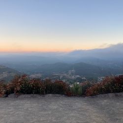
For starters, I wouldn't call this a mountain. It's more like a hill, and at 1150 feet, it is nothing in comparison to some of the Adirondack hikes I've been on late That said, this was a really great hike. I parked at the Piedra Pintada trailhead on the other side of Lake Hodge (which can hardly be called a lake at this point given the drought). I chose this primarily because it was a relatively easy place to park and the distance you have to walk on the bike trail isn't too bad once you reach the bike/pedestrian bridge. This area has a bit of traffic even on a morning mid-week. I arrived around 8:30 and made my way up the main bike trail to the Bernardo Mountain Peak trailhead. The trail is labeled only in two places that I noticed, but it is a well maintained trail and if you've got an app or map, you're not going to get lost. The trail to the summit is mixed with gradual increase in elevation over the entire 3.3 miles from the Piedra Pintada Trailhead parking. If you go in the morning, you're definitely going to get good portions of the trail in shade. The trail is narrow in parts as you get further up, but it wasn't overgrown. The summit is rather smallish - but there are enough spots to sit especially if there's not too many people there. You get really nice 360 views down to Lake Hodges, the neighborhoods surrounding the area, and of course I-15. I would rate this as an easy-moderate hike. It's really manageable, but on those sunny SoCal days (which are plentiful) you still need to prepare by bringing plenty of water to stay hydrated. I hiked with a 2L camelbak and an additional 1K nalgene to drink my hydration pack with. This was plenty for the 6.6mile roundtrip trek today. read more


This review is for the Bernardo Mountain Summit Via Coast To Crest Trail. Total miles was ~7 miles that took ~3 hours or so to complete. Small parking lot of maybe 20 cars and possibly some street parking as well. The first ~0.6 miles of the trail involves walking next to the freeway. Trail was mostly dirt and rocky for some areas with some inclines to the top. In addition, the trail was mostly exposed to the sun so be prepared. Overall, nice views of Lake Hodges and the distant landscapes near the summit! For those interested in the video of the hike! https://youtu.be/hkqN8VEalWM read more


I was looking for a trail greater than six miles with both water and a decent slope to ascend without having to go far inland. Bernardo Mountain seemed to fit that description as it was right along the boundary between Escondido and the city limits of San Diego. The trail was a part of the San Dieguito River Park which had many other paths to hike or bike. I parked at a dirt lot adjacent to the Sikes Adobe Historic Farmstead. There was a posted sign that the location was a staging area for a trail. The actual trailhead for the eastern point of the Bernardo Mountain Summit Trail was several hundred yards away to the southwest at the end of the Sunset Drive cul de sac. Hikers, bicyclists and horseback riders could all share the trail. The path started as a concrete sidewalk along the east side of I-15. It went south and then underneath the highway before turning north on the west side of I-15 (think of a horseshoe). At that point, it became a dirt path and more like a true natural hike. As the trek meandered westward and slightly south again, the Lake Hodges Bicycle/Pedestrian Bridge appeared on the left. It looked like a nice connector between the trail and some distant houses in Rancho Bernardo. Lake Hodges was to the south before you got to a sign which indicated it would be 1.9 miles to the summit of Bernardo Mountain. I had trekking poles with me to help with the ascent and descent. The path reminded me of the north side of Black Mountain as it became narrower with a lot more brush. Disappointingly, there was no sign at the peak indicating you had reached the top. The view of Lake Hodges and that of the surrounding neighborhoods of Escondido to the north and east were spectacular. The total round trip was about 7.2 miles which was longer than the climb to Mount Woodson starting from Lake Poway. It definitely was much less crowded than the journey to Potato Chip Rock which was certainly a positive. There wasn't much available shade so pick the right weather and time of the day to come here. read more


10 years ago
I hiked up the mountain! Yay me! I come to the San Dieguito River Park area often to get outdoors for a nice hike but I always try to stick with the easy flat areas. I've been wanting to try hiking Bernardo Mountain but i'm always more comfortable trying a new hike if I bring someone with me. My cousin has been wanting to hike up a big mountain so I thought Bernardo Mountain was nice to try. The hike is around under 8 miles out and back but my stupid new fitbit tracked some weird areas so it looked like we hiked 11 miles. Lol. The majority is flat for about 2 miles from the Sunset Dr trailhead. Go past the Felicita Creek then you should see the trailhead for Bernardo Mountain. The hike to the top is around 1.9 miles. I am not a person that likes inclines since I am not used to it. I had to catch my breath a few times. There were some steep areas and some flat areas. It is rocky when you get to the Bernardo Mountain trail so you need to make sure you have some good shoes. We saw plenty of people with hiking sticks. Some people mentioned that the sticks helped them a lot but you can do this hike without it. One of the steep areas we had to slide down since it's scary when you go back down! The view from the top is amazing. Lake Hodges is so beautiful! You can see so much up there. Definitely worth it to take this hike. There was a little sign in book in a plastic container. Someone must have removed the ammo box. Bernardo Mountain is a good moderate hike. I am overweight and out of shape but I was able to complete the longest hike of my life. It's not easy but it made me push myself to get to the top. So worth it! I am so happy I did this. :) read more


8 years ago
Enjoyable Hike This was a moderate hike with beautiful scenery near Rancho Bernardo/Escondido. This hike started with a flat path and gradually inclined to a very steep last half mile. Lots of wildlife, we saw roadrunners, lizards and a variety of birds. Tons of hummingbirds once we reached the top. At the top of the trail you have a gorgeous view of Lake Hodges. Awesome panoramic views of North County San Diego. Not many trees - remember your sunscreen and water. On the trail be mindful of mountain bikers, horseback riding and joggers. Have fun!!! read more


I saw the Bernardo Mountain trailhead sign while hiking along the Coast-to-Crest Trail in Escondido. Bernardo Mountain is listed at 1150 ft. in elevation and about a 1.9 mile hike to the top. It's probably not something to hike on the spur of the moment. The trail itself has various hiking patters but there are switchbacks, dirt trails, rock trails, and some steep sections. The top consists of small bolder like rocks and a good vantage point for panoramic pictures. Going down is a breeze, but remember which trail you came up on. I almost missed my trail turn off half way down. - If it's hot, there's no relief on the way up. Hat + lots of water + sunscreen. - Annoying swarming wasps at the top of the mountain. - Ammo box with a log book, a book of Mormon, various other items. - Not recommended for small kids. - 92 outside and still made it up. (Needed a water break a few times though). read more


9 years ago
It's been a while but I came back to this mtn since I needed something local. I enjoyed it more this time. Not a ton of ppl. I had deleted all trails off my phone so when I got to the 2 spots with no signs, I got nervous. I hung left and it ended up being the right choice. Watch out for mtn bikers! If you are a mtn biker, please have a bell. These bikers come up so fast that you don't hear them till they're too close to stop easily. My dog almost got ran over by one I didn't hear. The guy almost fell trying not to hit my dog who was on leash. Cool sighting today... saw deer! Shocked to see them so close to civilization. Literally right off the freeway part. read more


9 years ago
I have hiked around Lake Hodges a few times last year, saw the sign of Bernardo Mountain Summit but didn't go that way. After reading some reviews here, today I decided to give it a shot. Because I knew how to get there so driving isn't an issue. I'd rate this trail between easy to moderate. Some areas do get steep and rocky that make it difficult to hike, but if you have walking sticks like me, it will make a lot easier and safer when you come down. Round trip is about 10km from the pedestrian bridge to the summit. Let's talk about the view, when you get to the top, the view of the lake is spectacular! I took a panoramic one and you will know what I am talking about. Safety: well, I wasn't worried about the rattle snakes because they are probably still hibernating. Unlike Double Peak, this one is kind of quiet and isolated. Maybe not a lot of people know about this trail, I just ran into a few hikers today. Would I come back? Yes, but maybe next time with a buddy! read more


This review pertains to the entire hike from San Dieguito River Park off Via Rancho Parkway to the top of Bernardo Mountain and back. Total distance was just under 8 miles, and bear in mind I did this in mid-December when the weather is cool even at midday. For starters: the San Dieguito River Park Rangers are pretty awesome. I got into a long conversation with Brian, a Ranger before I set out and he explained the entire breadth of the watershed especially the Coast to Crest Trail and how far along the SDRP had come in establishing the trail officially. He was even able help me identify the un-named yet beflagged peninsula that juts out into the Lake Hodges Reservoir (It's Fletcher Point, or Flag point colloquially). Anyway, hats off to the Rangers, and Brian especially. The hike itself is typical San Diego: hilly, shrubby, boulder-y, you get my drift. Passing under the 15 was interesting but unspectacular. I do reccomend veering off trail about a mile and a half in to peruse the work of Escondido's local graffiti artists. An embankment with a grey boulder of immense size can be seen from the trail against the edge of a neighborhood. The grey boulder has been utterly destroyed, no doubt by the community developer many years ago. The pit is now filled with a rusty bicycle and shards of hundreds of beer bottles, all of which is surrounded by fairly extravagant graffiti. They've been using alot more than just spraypaint here. Take some time and take a look. If that kind of thing bothers you, ask yourself who's done more damage; the developer or the beer guzzling artisits? Moving up the trail a small bridge erected by "Team Trailbuilders" will take you over an absolutely lovely little creek to the Bernardo Summitt Trailhead. As you follow the north side of the mountain keep an eye out below, as that creek's source is in full view most of the way. It's an exceptionally pretty valley with tall Palm and Eucalyptus trees, and I believe it houses multiple murders of crows, at least it seemed to on my way down. Bernardo Mountain will not be necessarily easy. I reccomend bringing trekking poles to make sure you don't slip on the way back down, but most hikers won't need them. The peak itself has great views of Lake Hodges all the way out to the ocean, and during the summer would be an incredible spot to watch the sunset. I'm giving it 5 stars because it includes so much and because of the SDRP Rangers. Don't miss this hike. It's worth it. Happy Hiking read more


Great hike, totally worth the 7.7miles for the view It's a pretty moderate hike with some incline along the way. Ran into a rattlesnake which was pretty crazy, and I'm sure not super common, but it went about its own way so nothing to worry about. Just be aware of your surroundings & be prepared for a spectacular 360 view on top of the mountain! I would totally hike this again for a great workout outdoors. read more


10 years ago
13 years ago
More info about Bernardo Mountain
1217 Via De Encanto
Escondido, CA 92029
Directions
Hours
Indoor Amenities
Outdoor Amenities
Ask the Community - Bernardo Mountain
Review Highlights - Bernardo Mountain
You might also consider


Why does Yelp recommend reviews?
Bernardo Mountain - hiking - Updated July 2026
Best of Escondido
People found Bernardo Mountain by searching for…
Beautiful Views in Escondido, California
Hiking Trails With Waterfalls in Escondido, California
Parks in Escondido, California
Places to Take Pictures in Escondido, California
Watch Sunset in Escondido, California
Scenic View in Escondido, California
Walking Trails in Escondido, California
Night Hike in Escondido, California
View Points in Escondido, California
Dog Friendly Hiking Trails in Escondido, California
Bike Paths in Escondido, California
Free Things to Do in Escondido, California
Waterfalls and Swimming Holes in Escondido, California
Lakes & Ponds in Escondido, California
Waterfalls in Escondido, California
Off Leash Dog Hiking Trails in Escondido, California
Running Trails in Escondido, California
Bridge in Escondido, California
Dirt Bike Trails in Escondido, California
Easy Hikes in Escondido, California
Parks With Workout Equipment in Escondido, California
Sunset in Escondido, California
Trending Searches in Escondido, CA
4th Of July Fireworks near Bernardo Mountain
Black Owned Nail Salons near Bernardo Mountain
Boat Rental near Bernardo Mountain
Cliff Jumping near Bernardo Mountain
Day Trips near Bernardo Mountain
Fireworks near Bernardo Mountain
Jet Ski Rental near Bernardo Mountain
Kayak Rental near Bernardo Mountain
Lakes & Ponds near Bernardo Mountain
Off Road Trails near Bernardo Mountain
Outdoor Activities near Bernardo Mountain
Places To Walk Around near Bernardo Mountain
Public Pools near Bernardo Mountain
Public Shower near Bernardo Mountain
Rock Quarry near Bernardo Mountain
Running Trails near Bernardo Mountain
Scenic Night View near Bernardo Mountain
Scenic Overlook near Bernardo Mountain
Secluded Spots near Bernardo Mountain
Soccer Store near Bernardo Mountain
Splash Pad near Bernardo Mountain
Strawberry Picking near Bernardo Mountain
Sunrise View near Bernardo Mountain
Swimming Holes near Bernardo Mountain
Swimming Lakes near Bernardo Mountain
Swimming Pools near Bernardo Mountain
Watch Sunset near Bernardo Mountain
Browse Articles
Browse Nearby
BEST of Escondido, California Coffee near Bernardo Mountain
BEST of Escondido, California Restaurants near Bernardo Mountain
BEST of Escondido, California Things to Do near Bernardo Mountain
BEST of Escondido, California Parks near Bernardo Mountain
BEST of Escondido, California Breakfast near Bernardo Mountain
BEST of Escondido, California Lakes near Bernardo Mountain
BEST of Escondido, California Hot Springs near Bernardo Mountain
BEST of Escondido, California Campgrounds near Bernardo Mountain
Browse Brands
Related Searches in Escondido, CA
Affordable Kayak Rental Services in Escondido, California
Best Fishing Locations and Guides in Escondido, California
Best Nature Trails for Hiking in Escondido, California
Best Places for Horseback Riding in Escondido, California
Best Waterfalls and Swimming Holes in Escondido, California
Check Out Off Road Trails in Escondido, California
Discover Dog Friendly Trails to Explore in Escondido, California
Discover Kid Friendly Hiking Trails in Escondido, California
Discover Scenic Mountain Bike Trails Near Escondido, California
Discover Walking Parks in Escondido, California Near You
Discover a Hiking Trail in Escondido, California
Discover the Best Night Hike Trails in Escondido, California
Discover the Best Running Track in Escondido, California
Dog-Friendly Hikes With Dogs in Escondido, California
Enjoy Camping Adventures Around Escondido, California
Enjoy Exciting Mountain Biking Adventures in Escondido, California
Enjoy Kayaking Adventures in Escondido, California
Enjoy Tent Camping Spots Around Escondido, California
Enjoy a Beautiful Waterfall Hike in Escondido, California
Enjoy a Peaceful Nature Walk in Escondido, California
Enjoy the Best Picnic Spots and Ideas in Escondido, California
Enjoy the Best Walking Path in Escondido, California
Enjoy the Best Walking Trails in Escondido, California
Exciting Cliff Jumping Spots in Escondido, California
Explore Beautiful Parks and Green Spaces in Escondido, California
Explore Easy Hikes Perfect for All in Escondido, California
Explore Fun Activities to Do in Escondido, California
Explore Popular Campgrounds Near Escondido, California
Explore the Best Beach Spots in Escondido, California
Explore the Best Trail Options in Escondido, California
Family Friendly Hiking With Kids in Escondido, California
Find Beautiful Views in Escondido, California
Find Popular Ziplining Spots Around Escondido, California
Find the Best Parks for Picnics in Escondido, California
Great Places to Walk in Escondido, California
Hike the Popular Waterfall Trail in Escondido, California
Hiking Trails With Waterfalls in Escondido, California
Off Leash Dog Hiking Trails in Escondido, California
Popular Outdoor Activities to Try in Escondido, California
Popular Picnic Spots to Visit in Escondido, California
Safe River Swimming Areas in Escondido, California
Safe and Fun Parks for Kids in Escondido, California
Top Climbing Spots and Gyms in Escondido, California
Top Paddleboarding Activities in Escondido, California
Top Places for Snorkeling in Escondido, California
Top Running Trails to Explore in Escondido, California
Top Swimming Lakes to Enjoy in Escondido, California
Top Swimming Spots and Pools in Escondido, California
People who viewed Bernardo Mountain also viewed
Del Dios Highlands County Preserve
11 reviews
Stanley Peak
4 reviews
Boulder Loop Trail
6 reviews
Cougar Ridge Trail
3 reviews
Highland Valley Trail
9 reviews
Rancho Bernardo
Caballo Trail
3 reviews
Olivehain Municipal Water District Park S Department
2 reviews
Cleveland National Forest
35 reviews
Daley Ranch
112 reviews
Black Mountain Open Space Park
56 reviews
Mira Mesa, Torrey Hills