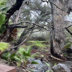
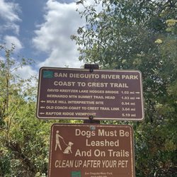
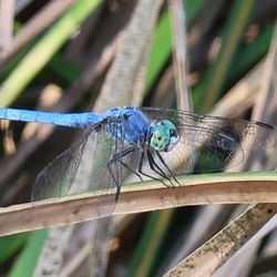
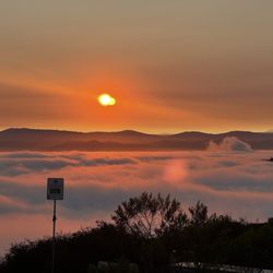
Daley Ranch Photos


You might also consider
More like Daley Ranch
Recommended Reviews - Daley Ranch
Start your review...

Reviews With Photos


My second time coming here today and it was wonderful! I was so nervous when I saw the almost-full parking lot at 7:45am on Memorial Day, but the most foot traffic we encountered was near the end of our hike on Creek Crossing, close to 9:30am, with folks entering the trailhead. A few had off-leash (big) dogs. Other than that...The trails are beautifully maintained. It was overcast the whole time we were there, but we didn't mind. Such vast beauty to enjoy. Can't wait to go back and explore more of the trails!

Time for an update! I haven't been to Daley Ranch on a weekday in many years. Weekends are crazy packed and not many people are wearing masks...but on the weekday, it's a different story. Parking was a breeze and there were barely any people out. Whoever was out took the current mask situation very seriously! Thank you, fellow maskers! The hike up to the Ranch House is 1.1 miles, so 2.2 roundtrip. It was a glorious sunny, yet cool day. My kids and I had a great time- fresh air, sunshine, and movement! It's not a challenging hike since the path we took was all asphalt, but there are some pretty decent inclines. Perfect for tiring my kids out! I have hiked several other trails at Daley Ranch, but when I'm with my kids I always chose the main Ranch House trail. There's a bathroom at the top, some benches, and picnic tables. Perfect resting spot. I'll be back!

So, these are my new stomping grounds, huh? Not bad. Not bad, at all. Having recently relocated from the Bay Area, most of my favorite & frequently visited trails for hiking & running up there were in Coastal Redwoods. Obviously, the climate, ecology, & environment of Daley Ranch is very much different, but the wonder of Nature still abounds. & there are lots of trails, so many trails. I've already logged a considerable amount of mileage out here, yet there are still hills unclimbed & routes unexplored. Just before the trailhead near Dixon Lake, there's a decent size free parking lot & a line of street parking. All of which can fill up. But with all the comings & goings when it's busy, a spot can usually be found without too much effort. & regardless of how crowded parking may be, the trails are often wide open with maybe just another person or 2 within line of sight. Go far enough out & you can have the outdoors all to yourself. Fantastic for some cardio, fresh air, & clearing out your head. All that mere minutes from home for me ain't bad. Not at all.

I went for the first time on Saturday (12/1/18) and really enjoyed the hike. I wish I lived closer to come back and explore more of this area but I unfortunately live about 90 miles away. We started our hike from the eastern part of Daley Ranch. There is a rather large dirt parking lot by a trailhead next to the San Diego Humane Society. Parking was free. We took the Caballo trail for about 1.8 miles until it meets up with Sage trail and we went to the right on Sage trail for about 1.5 miles and used the Stanley Peak trail for the last 3/4 of a mile to the top. Total mileage for us to the top was 4.1 miles (so 8.2 miles RT). There are a couple of steep parts on the trail...esp the last part to the peak but nothing too difficult and there are many parts that are either flat or with minimal incline. The elevation at the peak is about 1,973 ft and there is a gain of about 1,400 ft. I would rate this hike on the easy side of moderate. Give yourself about 3 to 4 hrs to complete. It wasn't too busy and we say more mountain bikers than we saw hikers. The views at the top are great, but kinda ordinary on the way. *hiking poles are not needed on this hike...depending on the weather conditions I think 1-2L of water is enough

What a gem in Escondido! Free parking, multiple trails and tons of information all over the ranch. For example, there is a clear Mission Statement and rules posted at the La Honda entrance. Also, you can pick up physical maps at the front (although its easier to DL it online and save it to your phone). There are free plastic poop bags and markers for certain plants like black sage and even caution signs for poison oak! This is a popular place for mountain bikers and for the most part, they ring their bells and let you know when they need to pass you.There are trails for all levels and little shade. Yeah there will be a few large trees here and there, but you'e in the middle of the rocky hills and mountains which is perfect to hike in peace. This is why I prefer this to Double Peak and Ridgeline trails. However, I just have to be a bit more prepped to hike here because once you start a trail you might want to connect to another and before you know it you'll have a few miles to loop back to your car. I suggest you wear shoes with good traction and some ankle support. A hat, sunglasses and some kind of neck covering won't hurt. Enjoy the views and the solitude without a sunburn! Passed a few people on the main road, but the trails are pretty free. Unfortunately, there is too much dog waste everywhere. The rules are clearly stated AND there are free baggies, people. I didn't see any horses, but I jumped around a large pile of horse poop on a narrow trail?!?! There is parking by Dixon Lake and on the street; another dirt lot on the back end by the SD Humane society which is good if you want to do Caballo to Sage. I haven't done Stanley Peak yet, but eventually. I'd say get here before 8 AM in the summer and bring enough water. You can refill it at the water fountains by the ranch house. Restrooms there are also open and available!

I wanted to try a new hike that was inland from Point Loma since it's still nice and cool so I drove to daily ranch in Escondido for the first time. It was easy to fine and there's plenty of parking and there's a great trail head with lots of maps so I took a map and figured out which way I was going to go. I went up Creek Crossing East Ridge to Sage all the way up to Stanley peak the mountain lilacs were a bloom and all the bushes were green and there were quite a few blooms on the monkey flower and the wild cucumber plants. I saw a little bunny rabbit as I started my hike. There's quite a few ponds along the hike and that's enjoyable to see they are man-made pond by the daily family for the wildlife in the area. It was a nice gentle uphill climb until the very last section up to this peak of Stanley Peak and it was a beautiful view from all angles. After enjoying a picnic lunch we walked back on the loop to the sage trail over to the ranch house so we could see the Homestead area it's right along the creek bed and it was very picturesque and while we were there we got to hear a concert of coyotes yipping for quite a long time and they were very close to us. After we rested there we walk down the Ranch House Road and it was very pretty with the oak trees lining the road and a view of middle Pond and it was a short walk from the ranch house back to our car so that's a quick way back if you don't want to take them any other options that branch off at the ranch house. We hiked about 7 1/2 miles and had a beautiful day and I will definitely come back and try some of the other trails next time. The nearby Dickson lake is a beautiful recreation area with a picnic groves and campgrounds in a little hiking trail as well. All in all it was a beautiful day

Started my adventure at the La Honda Drive entrance. Parking was plentiful. The ranch is open and due to covid-19 and mask are required; however, I noticed Not everyone complies. That being said, Daley Ranch is a unique place to hike, mountain bike or horseback ride. The ranch has 20 miles of trails in various levels of difficulty. I took the creek crossing trail, and I find the trail to be moderately strenuous and it provided a great workout. I noticed a lot of dogs on leashes, which is the requirement, and I noticed a lot of poop on the ground. Pretty sad that some pet owners are so negligent. Anyway, check out this link for more information and bring plenty of water and stay a: http://daleyranch.org/explore/history/

This is the second time I've been here, and the first time I've hiked it with just adults. There are a number of intersecting trails at Daley Ranch. Pick up a map at the entrance and plan your route for as long or as short as you'd like (or use the AllTrails map). The trails are marked by a number of posts, so it was pretty easy to navigate using the paper map. This time of the year, there were a ton of tiny frogs jumping all over the trails, so we had to be mindful of where we were stepping. Views of the lake were beautiful. The hills in that area made for a great workout. The only negative I noticed was that a lot of people did not care enough to pick up after their dog, which sucks.

Hiking trails galore.. Daley Ranch is my go to when seeking a good outdoor workout. This is like the inland, Escondido version of Torrey Pines being very expansive and views are all scenic. Parking here varies, when it's busy the parking lot gets full so then street parking becomes the only option. My usual hike would be the "Boulder Loop" trail which can be completed in an hour or two depending on your pace as it goes uphill and downhill, lots of good inclines. The cool thing about Daley Ranch is you can squeeze in a short hike or a long one depending on your mood, so many options! Everybody that hikes here is friendly and overall this a good option for hiking in North County. TIP: For beginners grab a paper map at the entrance to help guide you if needed. =]]

I love Daley Ranch! It's a great location in Escondido for hiking and mountain biking. There's a lot of parking available and plenty of trails to choose from. I rode mountain bikes out there with a couple of my girlfriends today. The trails are really fun, not too technical for bikes. Some absolutely beautiful view points especially along Boulder Loop. Unfortunately, we were moving too fast to stop and take a photo there, but we did get a selfie in front of the lake! There are porta potties at the parking lot and there are also some little bathroom houses inside the park. No running water though so be prepared with your hand sanitizer if you're planning to use it. read more


5 months ago
My second time coming here today and it was wonderful! I was so nervous when I saw the almost-full parking lot at 7:45am on Memorial Day, but the most foot traffic we encountered was near the end of our hike on Creek Crossing, close to 9:30am, with folks entering the trailhead. A few had off-leash (big) dogs. Other than that...The trails are beautifully maintained. It was overcast the whole time we were there, but we didn't mind. Such vast beauty to enjoy. Can't wait to go back and explore more of the trails! read more

Time for an update! I haven't been to Daley Ranch on a weekday in many years. Weekends are crazy packed and not many people are wearing masks...but on the weekday, it's a different story. Parking was a breeze and there were barely any people out. Whoever was out took the current mask situation very seriously! Thank you, fellow maskers! The hike up to the Ranch House is 1.1 miles, so 2.2 roundtrip. It was a glorious sunny, yet cool day. My kids and I had a great time- fresh air, sunshine, and movement! It's not a challenging hike since the path we took was all asphalt, but there are some pretty decent inclines. Perfect for tiring my kids out! I have hiked several other trails at Daley Ranch, but when I'm with my kids I always chose the main Ranch House trail. There's a bathroom at the top, some benches, and picnic tables. Perfect resting spot. I'll be back! read more

2 years ago
1 year ago
So, these are my new stomping grounds, huh? Not bad. Not bad, at all. Having recently relocated from the Bay Area, most of my favorite & frequently visited trails for hiking & running up there were in Coastal Redwoods. Obviously, the climate, ecology, & environment of Daley Ranch is very much different, but the wonder of Nature still abounds. & there are lots of trails, so many trails. I've already logged a considerable amount of mileage out here, yet there are still hills unclimbed & routes unexplored. Just before the trailhead near Dixon Lake, there's a decent size free parking lot & a line of street parking. All of which can fill up. But with all the comings & goings when it's busy, a spot can usually be found without too much effort. & regardless of how crowded parking may be, the trails are often wide open with maybe just another person or 2 within line of sight. Go far enough out & you can have the outdoors all to yourself. Fantastic for some cardio, fresh air, & clearing out your head. All that mere minutes from home for me ain't bad. Not at all. read more


2 years ago
I went for the first time on Saturday (12/1/18) and really enjoyed the hike. I wish I lived closer to come back and explore more of this area but I unfortunately live about 90 miles away. We started our hike from the eastern part of Daley Ranch. There is a rather large dirt parking lot by a trailhead next to the San Diego Humane Society. Parking was free. We took the Caballo trail for about 1.8 miles until it meets up with Sage trail and we went to the right on Sage trail for about 1.5 miles and used the Stanley Peak trail for the last 3/4 of a mile to the top. Total mileage for us to the top was 4.1 miles (so 8.2 miles RT). There are a couple of steep parts on the trail...esp the last part to the peak but nothing too difficult and there are many parts that are either flat or with minimal incline. The elevation at the peak is about 1,973 ft and there is a gain of about 1,400 ft. I would rate this hike on the easy side of moderate. Give yourself about 3 to 4 hrs to complete. It wasn't too busy and we say more mountain bikers than we saw hikers. The views at the top are great, but kinda ordinary on the way. *hiking poles are not needed on this hike...depending on the weather conditions I think 1-2L of water is enough read more


What a gem in Escondido! Free parking, multiple trails and tons of information all over the ranch. For example, there is a clear Mission Statement and rules posted at the La Honda entrance. Also, you can pick up physical maps at the front (although its easier to DL it online and save it to your phone). There are free plastic poop bags and markers for certain plants like black sage and even caution signs for poison oak! This is a popular place for mountain bikers and for the most part, they ring their bells and let you know when they need to pass you.There are trails for all levels and little shade. Yeah there will be a few large trees here and there, but you'e in the middle of the rocky hills and mountains which is perfect to hike in peace. This is why I prefer this to Double Peak and Ridgeline trails. However, I just have to be a bit more prepped to hike here because once you start a trail you might want to connect to another and before you know it you'll have a few miles to loop back to your car. I suggest you wear shoes with good traction and some ankle support. A hat, sunglasses and some kind of neck covering won't hurt. Enjoy the views and the solitude without a sunburn! Passed a few people on the main road, but the trails are pretty free. Unfortunately, there is too much dog waste everywhere. The rules are clearly stated AND there are free baggies, people. I didn't see any horses, but I jumped around a large pile of horse poop on a narrow trail?!?! There is parking by Dixon Lake and on the street; another dirt lot on the back end by the SD Humane society which is good if you want to do Caballo to Sage. I haven't done Stanley Peak yet, but eventually. I'd say get here before 8 AM in the summer and bring enough water. You can refill it at the water fountains by the ranch house. Restrooms there are also open and available! read more


I wanted to try a new hike that was inland from Point Loma since it's still nice and cool so I drove to daily ranch in Escondido for the first time. It was easy to fine and there's plenty of parking and there's a great trail head with lots of maps so I took a map and figured out which way I was going to go. I went up Creek Crossing East Ridge to Sage all the way up to Stanley peak the mountain lilacs were a bloom and all the bushes were green and there were quite a few blooms on the monkey flower and the wild cucumber plants. I saw a little bunny rabbit as I started my hike. There's quite a few ponds along the hike and that's enjoyable to see they are man-made pond by the daily family for the wildlife in the area. It was a nice gentle uphill climb until the very last section up to this peak of Stanley Peak and it was a beautiful view from all angles. After enjoying a picnic lunch we walked back on the loop to the sage trail over to the ranch house so we could see the Homestead area it's right along the creek bed and it was very picturesque and while we were there we got to hear a concert of coyotes yipping for quite a long time and they were very close to us. After we rested there we walk down the Ranch House Road and it was very pretty with the oak trees lining the road and a view of middle Pond and it was a short walk from the ranch house back to our car so that's a quick way back if you don't want to take them any other options that branch off at the ranch house. We hiked about 7 1/2 miles and had a beautiful day and I will definitely come back and try some of the other trails next time. The nearby Dickson lake is a beautiful recreation area with a picnic groves and campgrounds in a little hiking trail as well. All in all it was a beautiful day read more


6 years ago
Started my adventure at the La Honda Drive entrance. Parking was plentiful. The ranch is open and due to covid-19 and mask are required; however, I noticed Not everyone complies. That being said, Daley Ranch is a unique place to hike, mountain bike or horseback ride. The ranch has 20 miles of trails in various levels of difficulty. I took the creek crossing trail, and I find the trail to be moderately strenuous and it provided a great workout. I noticed a lot of dogs on leashes, which is the requirement, and I noticed a lot of poop on the ground. Pretty sad that some pet owners are so negligent. Anyway, check out this link for more information and bring plenty of water and stay a: http://daleyranch.org/explore/history/ read more


4 years ago
7 years ago
This is the second time I've been here, and the first time I've hiked it with just adults. There are a number of intersecting trails at Daley Ranch. Pick up a map at the entrance and plan your route for as long or as short as you'd like (or use the AllTrails map). The trails are marked by a number of posts, so it was pretty easy to navigate using the paper map. This time of the year, there were a ton of tiny frogs jumping all over the trails, so we had to be mindful of where we were stepping. Views of the lake were beautiful. The hills in that area made for a great workout. The only negative I noticed was that a lot of people did not care enough to pick up after their dog, which sucks. read more


Hiking trails galore.. Daley Ranch is my go to when seeking a good outdoor workout. This is like the inland, Escondido version of Torrey Pines being very expansive and views are all scenic. Parking here varies, when it's busy the parking lot gets full so then street parking becomes the only option. My usual hike would be the "Boulder Loop" trail which can be completed in an hour or two depending on your pace as it goes uphill and downhill, lots of good inclines. The cool thing about Daley Ranch is you can squeeze in a short hike or a long one depending on your mood, so many options! Everybody that hikes here is friendly and overall this a good option for hiking in North County. TIP: For beginners grab a paper map at the entrance to help guide you if needed. =]] read more


I've been on 2 kicks lately... Bars and Hikes... I have been on 3 hikes within the past month and I'm slowly getting addicted, especially if you go with the right company. What I enjoyed about DR is the fact that it's local and easy to get to from the 15/78 interchange. Additionally, there are many paths/tracks you can take depending on what you feel like. Free parking at the staging area and it's next to Dixon Lake. We decided to do a sunset hike. Steep incline from the staging area. I didn't care for all the potholes in the concrete. It's concrete for quite a ways until you hit the dirt trails. Not very scenic in comparison to my other hikes I've done. The trails are clean and wide. We decided to do a 2 mile hike up and pass the ranch house. We decided to trek up the hill to the top where a pond sits. We were disappointed that we couldn't see much from this vantage point. It was getting dark, so we decided to trek back. 4 mile easy hike... Again other trails to venture out on and the trails aren't very crowded. Better if you're on a mountain bike. read more


Hiking for the rest of us! Daley Ranch is a great place to casually hike around the oak and chaparral lined trails. In general, the trails are well maintained and easily traversed by all ages. Best hiking times are early morning, or afternoon. If you can walk up the first asphalt path, you can probably hike any of the trails here. One of my favorite hikes starts off at the Cougar Pass Rd parking lot. The ride up the dirt road up to the parking lot is an adventure in and of itself. Totally crazy drive at night. - From the parking lot take the cougar ridge trail until you hit the Bobcat trail, Go north a mile, and head east along the Engelmann Oak trail toward the water tower, cut back through the burnt trail, south on the Engelmann Oak trail again, and loop around back to the parking lot.. About 5 miles full of covered trails, nice views, nice elevations and hills.. - People are generally quite friendly here, saying hello when you cross paths. - Trails ( paved / dirt ) are for everyone, of all levels of ability. Kid friendly. Just be sure to bring alot of water! - Make it a goal to hike all 20 miles of trails. I'm close to getting all 20 miles under my belt. - Sunday is a good day to go because horses are prohibited on Sunday. - Many unique boulders and rocks. - Daily Ranch house has some chem cans and a working payphone but that's about it. - Lots of poop on the trails! Dog, Horse, and coyote. - If you really want to challenge yourself, go hike around Hellhole Canyon in Valley Center. You can access Dixon Lake for free from Daley Ranch. read more


This is tied for first place of my personal favorite north county hikes with the Torrey Pines one. First off there is FREE parking. Second there are SO many options and I like options. I never get too scared on these hikes because it is super people/ animal friendly. The trails acommodate people, dogs and horses. There are so many different trails that lead around the dixon lake area that every time I come back its a new adventure. The trails are more focused on enjoying nature then just climbing a mountain which I love because you can take kids or not be in top shape and its all good! Just bring water, look out for rattlesnakes and currently as of 3/2016 mountain lions. Enjoy the trails, and the beauty that is north county. read more


I've done a substantial amount of hiking here over the years and each time I am amazed that the city had the wherewithal to purchase this huge tract of land. Lots of great fauna and a guided sign trail indicating the local flora. Oak trees and water means poison oak so be aware. Trails of all difficulty levels are here. Most trails are exposed so bring water, a hat, and sunscreen. Interesting history, too, if you're into that. Close to Dixon lake on the south trail head entrance but I prefer the Cougar Pass entrance as the trails are more difficult and less trafficked. read more


10 years ago
What a fun hiking adventure to see Daley Ranch! What I loved about hiking yesterday was that the lilacs are in full bloom! That's definitely a beautiful sight to see everywhere. Make sure you grab a map. There are many trails to explore. Hopefully I'll be exploring others soon. The main thing I wanted to see is the Daley Ranch house. I suggest taking the dirt trails to go see it then you can walk the paved road on the way back to the car. The dirt trail is a little bit longer but looked much easier after seeing some of the hills we walked down. I would've hated hiking up some of those hills. The scenery was beautiful with all the lilac and saw some tiny ponds. I really liked seeing the barn near the ranch house. It's so beautiful. They have some picnic tables there so it's nice to sit under the trees and enjoy the cool breeze on a HOT February day. I was so glad I finally got to hike to Daley Ranch. Exploring all these trails will definitely be fun! read more


2 years ago
There are several trails you can hike at Daley Ranch, I took the trail to the right from the start but looped back around to get to boulder trail loop. I went later in the afternoon so it was cooler however there is not much shade so sunscreen is advised and a hat! The trails are good for all ages and I'd say are easy to moderate. There is plenty to see and if you decide to head down instead of up into Daley Ranch you have Dixon lake to explore. Make sure you have plenty of water especially during the warmer months. read more


6 years ago
Underrated but this is a real gem hidden in Escondido, great place for outdoor family activities from picnic, fishing, camping, hiking, biking etc. beautiful and scenic trail with great incline and decline with views to the valleys, lakes, dam, and canyons, breathtaking! read more

5 years ago
10 years ago
4 years ago
14 years ago
10 years ago
Daley Ranch is a great place to hike and dogs can also enjoy the trails on a leash, of course. There are several trails and each trail offers beautiful views. All of the trails include steep and/or slippery parts...lots of rock/dirt. It can get very warm in Escondido, especially during the summer months so plan accordingly. Bring plenty of water, a snack, a hat, sunscreen, and proper hiking boots/footwear. Follow the directions from the website since GPS will often take you to the other end of Daley Ranch and it is inaccessible from that particular location. read more

My favorite hike in the Escondido area. I have been numerous times and always tried different paths, as not always i feel like going all the way up. You can spend from an hour to all the day if you want. Keep in mind that there is almost no shade anywhere, so bring a lot of water and snacks with you. Also, better bring boots instead of sneakers, some areas can be really rough. It is a very peaceful place, it is an awesome way to get into shape while catching up with old and new friends. Very recommendable. read more


One of the best places for hiking in San Diego! Definately as good as it gets! You wouldn't really expect that bordering behind the busy city of Escondido is a hidden jewel of MANY hiking trails. Very convenient location. Not too overcrowded since there are numerous trails to pick from with different milage and difficulty. Pretty lake views and at the entrance and again at the ranch house they have a big water dish for dogs and drinking water for humans. :) Bikers, horses, and dogs are all welcome here! Love hiking here, awesome place! read more

018 / 100 - 2016 YELP 100 CHALLENGE. I've been wanting to expand my portfolio for a while now and my bestie wanted to do a photoshoot of her crossplay cosplay of Joel from the The Last of Us, soooooo we decided to look at a bunch of different locations in San Diego to get the right vibe. We came across Daley Ranch, saw all the abandoned buildings and thought to ourselves "why the hell not!?" The distance to the abandoned buildings was about a 1-2 mile hike. The hike itself wasn't bad at all (there was a lot of uphill), but the day we went it was unbearably hot and incredibly sunny... so we were pretty miserable by the end of it. We took some great pictures, everyone we ran into was incredibly nice, and overall had a great time. The only downside to Daley Ranch was FINDING it -- hence the 4 star instead of 5. The directions on the Daley Ranch website are terrible, really wish there was more info. Google Maps ended up taking us to some guy's private property. How awkward. It took us at least 30 minutes to go around and find it and it was so, so frustrating. Aside from all of that, great spot with fantastic scenery. read more


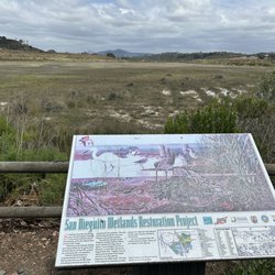
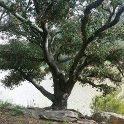
This is a very beautiful area with lots of native plants. The main road from the Dixon Lake area is paved all the way to the ranch; however, the road is blocked off to vehicle traffic. Runners, mountain bikers, and even equestrians can find trails to use around the ranch. If you head out for a hike, please take plenty of water as it gets hot out on the trail. I've seen folks out on the trail with no water or even headgear on which isn't the best decision. Hiking is lots of fun and great exercise, but it can be dangerous if you don't pay attention to the weather conditions. Okay, enough with the lecture...back to the ranch. This area is one of the remaining places in San Diego where you can find Engelmann Oak ~ Quercus engelmannii. These gorgeous bluish-green leafed oak used to be wide spread across the region, but unfortunately most have been cut down in the name of progress so we are only left with a few sporadic stands across the county. Daley Ranch is a nice easy area to hike with the family and a great opportunity to see lots of native vegetation. read more


Page 1 of 3
More info about Daley Ranch
3024 La Honda Dr
Escondido, CA 92027
Directions
(760) 839-4680
Call Now
Hours
Indoor Amenities
Outdoor Amenities
Ask the Community - Daley Ranch
Review Highlights - Daley Ranch
You might also consider


Why does Yelp recommend reviews?
Daley Ranch - hiking - Updated August 2026
Best of Escondido
People found Daley Ranch by searching for…
Abandoned Buildings in Escondido, CA
Horseback Riding in Escondido, CA
Places to Take Pictures in Escondido, CA
Hiking Trails in Escondido, CA
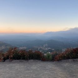
Beautiful Views in Escondido, CA
Walking Trails in Escondido, CA
Dog Friendly Things to Do in Escondido, CA
Off Road Trails in Escondido, CA
Dog Friendly Hiking Trails in Escondido, CA
Running Trails in Escondido, CA
Redwood Trees in Escondido, CA
Trending Searches in Escondido, CA
Beautiful Views near Daley Ranch
Blueberry Picking near Daley Ranch
Cliff Jumping near Daley Ranch
Cruising Spots near Daley Ranch
Dog Friendly Things To Do near Daley Ranch
Dog Friendly Trails near Daley Ranch
Flower Fields near Daley Ranch
Free Picnic Areas near Daley Ranch
Indoor Mini Golf near Daley Ranch
Jet Ski Rental near Daley Ranch
Kids Activities Indoor near Daley Ranch
Lookout Points near Daley Ranch
Nature Trails near Daley Ranch
Off Road Trails near Daley Ranch
Outdoor Activities near Daley Ranch
Peach Picking near Daley Ranch
River Swimming near Daley Ranch
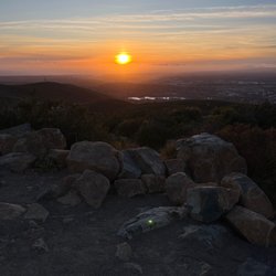
Scenic Night View near Daley Ranch
Scenic Overlook near Daley Ranch
Swimming Holes near Daley Ranch
Browse Articles
Browse Nearby
BEST of Escondido, California Coffee near Daley Ranch
BEST of Escondido, California Things to Do near Daley Ranch
BEST of Escondido, California Restaurants near Daley Ranch
BEST of Escondido, California Walking Trails near Daley Ranch
BEST of Escondido, California Breakfast near Daley Ranch
BEST of Escondido, California Parks near Daley Ranch
Browse Brands
Related Searches in Escondido, CA
Affordable Bike Repair Services in Escondido, California
Affordable Bike Tune Up Services in Escondido, California
Affordable Cheap Bike Tune Up Services in Escondido, California
Affordable Kayak Rental Services in Escondido, California
Affordable Road Bike Rental in Escondido, California
Best Dirt Bike Riding Spots in Escondido, California
Best Dog Hiking Trails Around Escondido, California
Best Electric Bike Rental Services in Escondido, California
Best Fishing Locations and Guides in Escondido, California
Best Nature Trails for Hiking in Escondido, California
Best Places for Horseback Riding in Escondido, California
Best Sightseeing Experiences Available in Escondido, California
Best Sledding Spots and Fun in Escondido, California
Check Out Off Road Trails in Escondido, California
Convenient Bike Sharing Programs in Escondido, California
Discover Dog Friendly Trails to Explore in Escondido, California
Discover Easy Hiking Trails Near Escondido, California
Discover Kid Friendly Hiking Trails in Escondido, California
Discover Popular Bike Tours in Escondido, California
Discover Popular Bike Trails in Escondido, California
Discover Scenic Bike Paths in Escondido, California
Discover Scenic Mountain Bike Trails Near Escondido, California
Discover Walking Parks in Escondido, California Near You
Discover a Hiking Trail in Escondido, California
Discover the Best Night Hike Trails in Escondido, California
Dog-Friendly Hikes With Dogs in Escondido, California
Enjoy Biking Adventures Around Escondido, California
Enjoy Camping Adventures Around Escondido, California
Enjoy Hiking Adventures in Escondido, California
Enjoy Kayaking Adventures in Escondido, California
Enjoy Off Leash Dog Hikes in Escondido, California
Enjoy Scenic Dirt Bike Trails Around Escondido, California
Enjoy Scenic Places to Walk in Escondido, California
Enjoy Tent Camping Spots Around Escondido, California
Enjoy a Beautiful Waterfall Hike in Escondido, California
Enjoy the Best Walking Path in Escondido, California
Enjoy the Best Walking Trails in Escondido, California
Explore BMX Bike Shops Near Escondido, California
Explore Beautiful Parks and Green Spaces in Escondido, California
Explore Bike Rentals Throughout Escondido, California
Explore Cycling Stores in Escondido, California
Explore Easy Hikes Perfect for All in Escondido, California
Explore Electric Bikes Available in Escondido, California
Explore Fun Activities to Do in Escondido, California
Explore Picnic Parks Near Escondido, California
Explore Popular Campgrounds Near Escondido, California


