Hellhole Canyon County Preserve Photos


You might also consider
More like Hellhole Canyon County Preserve
Recommended Reviews - Hellhole Canyon County Preserve
Start your review...

Reviews With Photos

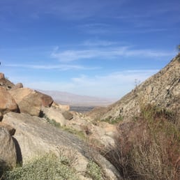
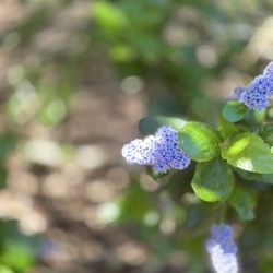
Hellhole canyon is a great hike to do in the spring, with all the rain we had, flowers are blooming and there is lots of green areas, nature is pretty here. There is an anti theater area and group camping sites, very clean, organized and maintain with surrounding blooming bushes. Sunsets are beautiful from this area Bathrooms and drinking water available at the entrance Well maintained parking area, spaces for cars and horses We saw bees, monarch butterflies, lizards and many other insects Little water stream at the bottom of the hill. This hike from the parking lot and entrance takes you downhill, reach the stream after that is an easy hike but coming back up is hiking the hill out, might be thought depending on your physical condition, slow and rest and is easy to enjoy. Bring water, hat and sunblock, there is no tree shade. We use the GPS to find this place, otherwise we will probably get lost as it takes you around many roads.

Beautiful place to hike. Some shady spots to take breaks but DEFINITELY bring water. Very hot and dry when the sun it beating down on you. I had hummingbirds fly right in front of my face and hover there, saw lots of beautiful lizards, went past a running creek and enjoyed the open space, never passing by any other people. I do recommend hiking this with other people if you can though, just for safety because it does get so hot and there are lots of bees and for any other safety reason. lovely place to start a morning hike! Bring a sun hat and sunblock! If you bring a pet, you may have to pick them up and carry them; it was too hot for our small dog to walk on the ground.

A place of extreme misery.. I hike here alone during the summer months to challenge myself. Kinda like my own personal walkabout. The other reviewers did a good job of describing this place, but here are a few additional points to be aware of. - Wear a big hat. Look this isn't opening day at Del Mar so no need to be worried about style points. I bought my sombrero at the local Mexican grocery store. - Bring more water than you would normally drink in a whole day. Trust me on this. Also bring an apple or two. - It took me 2 hours to hike from the parking lot to the top of the viewpoint. However, I was fully prepared to make the trek up there. This place is HOT and there is very little shade. - Some trails are overgrown and some are very hard to follow. I've deviated from the trail a few times by accident ( specifically heading west on the ocean trail). - Not a lot of people hike these trails, so you're in a world of hurt if you get stuck. Cell phone service is spotty. - The top viewpoint is worth the hike. Make sure you do the full loop counterclockwise. Mountain Lion Tracks.. Beware! http://www.yelp.com/biz_photos/hellhole-canyon-open-space-preserve-valley-center?select=hAhN1yB9f7o229E8mVyk-w#NkawEbvl3kruADlCBrsjFg Air Rescue - Don't let this be you! http://www.yelp.com/biz_photos/hellhole-canyon-open-space-preserve-valley-center?select=hAhN1yB9f7o229E8mVyk-w#iI-wnuj0fcIFGSKUdHGifQ

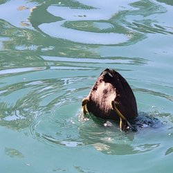
Nice peaceful hike Pros Well marked trails Secluded (only saw 4 other people while i was there) A small river crossing (maybe more after a rain?) Variety of flowers plants and trees (a few signs telling you what some of the plants were) Graveled parking area Porta potty bathrooms You can choose different trails to make it a longer or shorter hike (6 or 8 mile loop or longer if you want) Cons: - although the trails are well marked, it is somewhat over grown (since its not highly trafficted) so bring long pants if you don't want you shins to rub against the brush. - people bring their horses there so theres a bunch of horse poop. - with a name like hellhole, you can imagine that it gets hot in the afternoon. Notes: Go early (or in cooler months) to avoid excessive heat. Moderate difficulty (Hiking shoes required for loose terrain and some up and down hill parts) Long pants prefered to avoid the brush, but shorts preferred for coolness. (decisions.... decisions...) Bring a Hat and water (not much tree coverage) Take a trail map at the beginning of the trail.

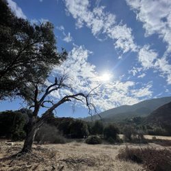
GETTING THERE. One way to drive to HELLHOLE CANYON PERSERVE is from ROUTE 15. You exit at VIA RANCHO PARKWAY, and to travel to the east. GOOGLE map states that the name of Via Rancho Parkway is Bear Valley Parkway. But this is garbled and wrong. The correct name is Via Rancho Parkway. After a couple of blocks, Via Rancho Parkway makes a sharp bend, and turns north, and at this bend the street changes its name to BEAR VALLEY PARKWAY. Then, Bear Valley Parkway changes its name to VALLEY CENTER ROAD. Once on Valley Center Road, you turn right (to the east) on LAKE WHOLFORD ROAD. From then on, your drive will be on narrow streets that wind around a mountain side and then, after that, narrow streets that pass neighborhoods in farming areas. Eventually, Lake Wholford Road changes its name to PARADISE MOUNTAIN ROAD. GOOGLE map states that the name is Woods Valley Road, but this is not correct. The correct situation is that they are one and the same road. To the east of Lake Wholford Rd., the name is Woods Valley Rd., and to the west of Lake Wholford Rd., the name is Paradise Mtn. Rd. Fortunately, along my way I encountered two or three little signs by the road that said, "Hellhole Canyon Preserve" is this way. MANY FLOWERS. FEW PEOPLE. There is no fee. The trailhead is inviting enough, and on the hike down into a canyon, you encounter signs that identify a nearby plant. One by one by one, you will encounter signs that read: (1) Lemonade Berry Sugar Bush; (2) Chamise; (3) Hoary leaf lilac; (4) Black sage; and then there is a large 3 ft. x 4 ft. plaque that explains the "2003 Paradise Fire," and finally (5) California buckwheat. At this time of year (May), most parts of the trail during my two hour hike were bordered by flowers. Mostly, yellow flowers. Typically, the stems of these flowers arched over the trail, and many were at shoulder height (providing that you are about 5 and 1/2 feet tall). Black sage resembles another plant, namely, fiddledock. Despite its name, Black sage has many blossoms that are colored light violet. There are many Hesperoyucca whipplei. At certain times of the year, this type of yucca sprouts fruits that are dark green and that look exactly like tiny bell peppers. Most of the yucca that I saw had a brightly colored collection of blossoms.During my entire walk, I encountered three couples (man plus woman). Two of the couples had a dog. One of the women was an engineering student at U.C. Irvine. One of the men was a fireman. ANIMALS ON OR NEAR THE TRAIL. During the entire hike, I encountered several lizards. One was sitting on a granite boulder by the trail, and the others were crossing the trail. I encountered one black beetle, perhaps a "stinkbug," crossing the trail. I encountered one snake. Mister Snake was very small, and it was crawling across the trail and into the bushes. At two points in the trail, I heard a bird call that went like this: EEK-EEK-EEK-jih-jih-jih-jih-jih-jih-jih-jih-jih-jih-jih-ghghghghgh. The last part of this bird call (ghghghghgh) was a sound that faded out. At a couple of points in my hike, I heard a dove cooing. To reduce the chance of an encounter with mountain lions, I carried a fully extended seven foot long silver-colored aluminum tripod (15 pounds). My theory was that mountain lions would confuse me for being a radio tower, and then leave me alone. ROCKS. There are many huge granite boulders. Most amazing are the granite boulders that have exposed veins of white quartz. Two of these veins can be seen on the main trail, where they occur in between the lower terminus of the HORSE THIEF TRAIL and the upper terminus of the HORSE THIEF TRAIL. I did not have my camera along, and so I am here posting photographs of white quartz veins in the granite at JOSHUA TREE NATIONAL PARK. The National Park Service describes the quartz veins as follows: "Visitors also wonder about the "broken terrace walls" laced throughout the boulders. These are naturally occurring formations called dikes. Younger than the surrounding monzogranite, dikes were formed when molten rock was pushed into existing joint fractures. Light-colored aplite, pegmatite, and andesite dikes formed as a mixture of quartz and potassium minerals cooled in these tight spaces. Suggesting the work of a stonemason, they broke into uniform blocks when they were exposed to the surface." My entire hike was 5.2 miles, as measured by the hiking map. I took HISTORIC FLUME TRAIL, which brings you past the flower signs (and the flowers) and to the bottom of a canyon where there is flowing water. Charred trees occur here and there. Some of the charred trees are totally dead, while others have recovered from the fire and are covered with newly grown small branches and leaves. Then, this same trail changes its name to CANYON VIEW TRAIL. RODRIGUEZ PEAK TRAIL is very much overgrown with weeds, and so I did not take it (I didn't want to get lost).

Whenever the hubby & I go on a road trip, we like to find points of interest and check them out. I was looking at the Google map of the area.... Me- "Hellhole Canyon. That sounds interesting. It's not too far off our path." Exploration fail. And, it's on me. I'M A BIG CHICKEN! We find the sign pointing the way and started up the road. I'm looking at its Yelp page and read the first few reviews. "Hmmm, I don't think we'll pass muster with this Tim guy. He'd take one look at me in my Skecher walking shoes & cup of iced coffee and laugh." Then I see the pics of the mountain lion paw print & the snake. Oh hell no. "Turn around! Turn around!" This hiking trail is best left to the experienced brave folks. Definitely not for the unprepared (us) out for a spur-of-the-moment adventure. (We went to go eat at the Pauma buffet instead.) O_o

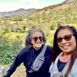
This past weekend, I hiked Hellhole Canyon. The whole damn thing. Up the mountain, down the mountain. Make sure you are in relative shape before making the hike. I'm not and two days later I can barely walk. I digress... My GPS had no problem finding the location in which to park. When you arrive, you'll find two well maintained out houses, a trailer for whomever I'm assuming manages this property, and water for you and your four legged friend (dog and horse variety). Oh... And MAPS! Take a map... What I think is great about this location is that you can choose your experience. You can enjoy a shorter four mile scenic route (easy to moderate, depending on the route) or you can follow the parameters and take an eight + mile moderate to hard route. Either way, the views are amazing. The trails are well marked.

Absolutely breathtaking views, went after the rains on Sunday February 17th, right when they opened. There was a small stream of water that was manageable to cross, it feed into a larger stream that you barely can see from the path. It's not something your able to get too, or at least that I could tell. Tried to make it to the view points but it started to rain and I wasn't sure if I was going the right way or not. I would definitely come back to this spot. Oh in miles I did approximately 5, round trip.

This hike is absolutely horrendous. Originally planning on another hike with friends last weekend, and that places passes had sold out, so we stumbled upon this hike on yelp. Very intrigued by the name as we are all metal loving freaks of nature, we decided to give it a try! The entire loop is something like 8 miles?? With no water in sight and the only shade is if you lay underneath a small bush, this place is very suited for its name Hellhole. 6 of us, mostly in good shape, mid-afternoon, made it half way and decided to turn back. We would love to try it again and do the whole route. Seriously, bring way more water than you ever do. SERIOUSLY you're gonna need it. A hat, sunscreen, music, no dogs cause they'd probably die. I highly recommend this to anyone in or out of shape. It's a b**ch1/2 and you will feel so amazing after you conquer near death experiences in Hellhole.
One of my favorite late winter early spring hikes in San Diego. If you time it just right, you will see the most gorgeous flowers all over the trail. I was a little bit early this spring, the flowers are just starting to come out! My guess is two weeks from now it's going to pop. You do not want to come out here and hike in the summer, it's got the name Hellhole Canyon for a reason. It gets dangerously hot and there is no guarantee that anyone's going to rescue you. You can put together a monster hike in this canyon. I've done it twice over 10 miles with an ass blaster of a climb. But today I did the shorter loop which is 5.25 miles. It's got everything, views, climbing and descending and varied terrain! We rarely see anybody out here but today we actually passed three small groups on the trail. You can tell that a lot of people use the trails also with horses because we saw some horse poop and in the distance we could hear horse whinnies- so cute!!! Another bonus is at this trailhead. There are two pit toilets that are the nicest pit toilets I have ever been in. The people that maintain this canyon do an excellent job. They are always clean, stocked with toilet paper and have hand sanitizer. I will 100% be back to this trail, possibly in two weeks! If you're going to do it, I highly recommend downloading the AllTrails app and following the trail as marked. No way you'll get lost. read more


1 year ago


4 years ago
This is beautiful hike/walk. No shade on the trail but the silence is divine. Bring walking shoes and lots of water. You can walk your dogs off leash. read more

Hellhole canyon is a great hike to do in the spring, with all the rain we had, flowers are blooming and there is lots of green areas, nature is pretty here. There is an anti theater area and group camping sites, very clean, organized and maintain with surrounding blooming bushes. Sunsets are beautiful from this area Bathrooms and drinking water available at the entrance Well maintained parking area, spaces for cars and horses We saw bees, monarch butterflies, lizards and many other insects Little water stream at the bottom of the hill. This hike from the parking lot and entrance takes you downhill, reach the stream after that is an easy hike but coming back up is hiking the hill out, might be thought depending on your physical condition, slow and rest and is easy to enjoy. Bring water, hat and sunblock, there is no tree shade. We use the GPS to find this place, otherwise we will probably get lost as it takes you around many roads. read more


Beautiful place to hike. Some shady spots to take breaks but DEFINITELY bring water. Very hot and dry when the sun it beating down on you. I had hummingbirds fly right in front of my face and hover there, saw lots of beautiful lizards, went past a running creek and enjoyed the open space, never passing by any other people. I do recommend hiking this with other people if you can though, just for safety because it does get so hot and there are lots of bees and for any other safety reason. lovely place to start a morning hike! Bring a sun hat and sunblock! If you bring a pet, you may have to pick them up and carry them; it was too hot for our small dog to walk on the ground. read more


A place of extreme misery.. I hike here alone during the summer months to challenge myself. Kinda like my own personal walkabout. The other reviewers did a good job of describing this place, but here are a few additional points to be aware of. - Wear a big hat. Look this isn't opening day at Del Mar so no need to be worried about style points. I bought my sombrero at the local Mexican grocery store. - Bring more water than you would normally drink in a whole day. Trust me on this. Also bring an apple or two. - It took me 2 hours to hike from the parking lot to the top of the viewpoint. However, I was fully prepared to make the trek up there. This place is HOT and there is very little shade. - Some trails are overgrown and some are very hard to follow. I've deviated from the trail a few times by accident ( specifically heading west on the ocean trail). - Not a lot of people hike these trails, so you're in a world of hurt if you get stuck. Cell phone service is spotty. - The top viewpoint is worth the hike. Make sure you do the full loop counterclockwise. Mountain Lion Tracks.. Beware! http://www.yelp.com/biz_photos/hellhole-canyon-open-space-preserve-valley-center?select=hAhN1yB9f7o229E8mVyk-w#NkawEbvl3kruADlCBrsjFg Air Rescue - Don't let this be you! http://www.yelp.com/biz_photos/hellhole-canyon-open-space-preserve-valley-center?select=hAhN1yB9f7o229E8mVyk-w#iI-wnuj0fcIFGSKUdHGifQ read more


Nice peaceful hike Pros Well marked trails Secluded (only saw 4 other people while i was there) A small river crossing (maybe more after a rain?) Variety of flowers plants and trees (a few signs telling you what some of the plants were) Graveled parking area Porta potty bathrooms You can choose different trails to make it a longer or shorter hike (6 or 8 mile loop or longer if you want) Cons: - although the trails are well marked, it is somewhat over grown (since its not highly trafficted) so bring long pants if you don't want you shins to rub against the brush. - people bring their horses there so theres a bunch of horse poop. - with a name like hellhole, you can imagine that it gets hot in the afternoon. Notes: Go early (or in cooler months) to avoid excessive heat. Moderate difficulty (Hiking shoes required for loose terrain and some up and down hill parts) Long pants prefered to avoid the brush, but shorts preferred for coolness. (decisions.... decisions...) Bring a Hat and water (not much tree coverage) Take a trail map at the beginning of the trail. read more


GETTING THERE. One way to drive to HELLHOLE CANYON PERSERVE is from ROUTE 15. You exit at VIA RANCHO PARKWAY, and to travel to the east. GOOGLE map states that the name of Via Rancho Parkway is Bear Valley Parkway. But this is garbled and wrong. The correct name is Via Rancho Parkway. After a couple of blocks, Via Rancho Parkway makes a sharp bend, and turns north, and at this bend the street changes its name to BEAR VALLEY PARKWAY. Then, Bear Valley Parkway changes its name to VALLEY CENTER ROAD. Once on Valley Center Road, you turn right (to the east) on LAKE WHOLFORD ROAD. From then on, your drive will be on narrow streets that wind around a mountain side and then, after that, narrow streets that pass neighborhoods in farming areas. Eventually, Lake Wholford Road changes its name to PARADISE MOUNTAIN ROAD. GOOGLE map states that the name is Woods Valley Road, but this is not correct. The correct situation is that they are one and the same road. To the east of Lake Wholford Rd., the name is Woods Valley Rd., and to the west of Lake Wholford Rd., the name is Paradise Mtn. Rd. Fortunately, along my way I encountered two or three little signs by the road that said, "Hellhole Canyon Preserve" is this way. MANY FLOWERS. FEW PEOPLE. There is no fee. The trailhead is inviting enough, and on the hike down into a canyon, you encounter signs that identify a nearby plant. One by one by one, you will encounter signs that read: (1) Lemonade Berry Sugar Bush; (2) Chamise; (3) Hoary leaf lilac; (4) Black sage; and then there is a large 3 ft. x 4 ft. plaque that explains the "2003 Paradise Fire," and finally (5) California buckwheat. At this time of year (May), most parts of the trail during my two hour hike were bordered by flowers. Mostly, yellow flowers. Typically, the stems of these flowers arched over the trail, and many were at shoulder height (providing that you are about 5 and 1/2 feet tall). Black sage resembles another plant, namely, fiddledock. Despite its name, Black sage has many blossoms that are colored light violet. There are many Hesperoyucca whipplei. At certain times of the year, this type of yucca sprouts fruits that are dark green and that look exactly like tiny bell peppers. Most of the yucca that I saw had a brightly colored collection of blossoms.During my entire walk, I encountered three couples (man plus woman). Two of the couples had a dog. One of the women was an engineering student at U.C. Irvine. One of the men was a fireman. ANIMALS ON OR NEAR THE TRAIL. During the entire hike, I encountered several lizards. One was sitting on a granite boulder by the trail, and the others were crossing the trail. I encountered one black beetle, perhaps a "stinkbug," crossing the trail. I encountered one snake. Mister Snake was very small, and it was crawling across the trail and into the bushes. At two points in the trail, I heard a bird call that went like this: EEK-EEK-EEK-jih-jih-jih-jih-jih-jih-jih-jih-jih-jih-jih-ghghghghgh. The last part of this bird call (ghghghghgh) was a sound that faded out. At a couple of points in my hike, I heard a dove cooing. To reduce the chance of an encounter with mountain lions, I carried a fully extended seven foot long silver-colored aluminum tripod (15 pounds). My theory was that mountain lions would confuse me for being a radio tower, and then leave me alone. ROCKS. There are many huge granite boulders. Most amazing are the granite boulders that have exposed veins of white quartz. Two of these veins can be seen on the main trail, where they occur in between the lower terminus of the HORSE THIEF TRAIL and the upper terminus of the HORSE THIEF TRAIL. I did not have my camera along, and so I am here posting photographs of white quartz veins in the granite at JOSHUA TREE NATIONAL PARK. The National Park Service describes the quartz veins as follows: "Visitors also wonder about the "broken terrace walls" laced throughout the boulders. These are naturally occurring formations called dikes. Younger than the surrounding monzogranite, dikes were formed when molten rock was pushed into existing joint fractures. Light-colored aplite, pegmatite, and andesite dikes formed as a mixture of quartz and potassium minerals cooled in these tight spaces. Suggesting the work of a stonemason, they broke into uniform blocks when they were exposed to the surface." My entire hike was 5.2 miles, as measured by the hiking map. I took HISTORIC FLUME TRAIL, which brings you past the flower signs (and the flowers) and to the bottom of a canyon where there is flowing water. Charred trees occur here and there. Some of the charred trees are totally dead, while others have recovered from the fire and are covered with newly grown small branches and leaves. Then, this same trail changes its name to CANYON VIEW TRAIL. RODRIGUEZ PEAK TRAIL is very much overgrown with weeds, and so I did not take it (I didn't want to get lost). read more


11 years ago
Whenever the hubby & I go on a road trip, we like to find points of interest and check them out. I was looking at the Google map of the area.... Me- "Hellhole Canyon. That sounds interesting. It's not too far off our path." Exploration fail. And, it's on me. I'M A BIG CHICKEN! We find the sign pointing the way and started up the road. I'm looking at its Yelp page and read the first few reviews. "Hmmm, I don't think we'll pass muster with this Tim guy. He'd take one look at me in my Skecher walking shoes & cup of iced coffee and laugh." Then I see the pics of the mountain lion paw print & the snake. Oh hell no. "Turn around! Turn around!" This hiking trail is best left to the experienced brave folks. Definitely not for the unprepared (us) out for a spur-of-the-moment adventure. (We went to go eat at the Pauma buffet instead.) O_o read more

This past weekend, I hiked Hellhole Canyon. The whole damn thing. Up the mountain, down the mountain. Make sure you are in relative shape before making the hike. I'm not and two days later I can barely walk. I digress... My GPS had no problem finding the location in which to park. When you arrive, you'll find two well maintained out houses, a trailer for whomever I'm assuming manages this property, and water for you and your four legged friend (dog and horse variety). Oh... And MAPS! Take a map... What I think is great about this location is that you can choose your experience. You can enjoy a shorter four mile scenic route (easy to moderate, depending on the route) or you can follow the parameters and take an eight + mile moderate to hard route. Either way, the views are amazing. The trails are well marked. read more


7 years ago
Absolutely breathtaking views, went after the rains on Sunday February 17th, right when they opened. There was a small stream of water that was manageable to cross, it feed into a larger stream that you barely can see from the path. It's not something your able to get too, or at least that I could tell. Tried to make it to the view points but it started to rain and I wasn't sure if I was going the right way or not. I would definitely come back to this spot. Oh in miles I did approximately 5, round trip. read more

10 years ago
This hike is absolutely horrendous. Originally planning on another hike with friends last weekend, and that places passes had sold out, so we stumbled upon this hike on yelp. Very intrigued by the name as we are all metal loving freaks of nature, we decided to give it a try! The entire loop is something like 8 miles?? With no water in sight and the only shade is if you lay underneath a small bush, this place is very suited for its name Hellhole. 6 of us, mostly in good shape, mid-afternoon, made it half way and decided to turn back. We would love to try it again and do the whole route. Seriously, bring way more water than you ever do. SERIOUSLY you're gonna need it. A hat, sunscreen, music, no dogs cause they'd probably die. I highly recommend this to anyone in or out of shape. It's a b**ch1/2 and you will feel so amazing after you conquer near death experiences in Hellhole. read more


9 years ago
14 years ago
14 years ago
14 years ago
This hike is more of an exploration than a hike. When my boyfriend and I stared out on the trail (the trailhead is at the parking lot), we started off on well defined trail. After about a mile and a half, we had to take a more, "do you see footprints over there? Let's follow them." But to be honest, that make it more fun. Moderate scrambling, but the scrambling comes once you make it to the palm oasis and trickling waterfall, and it's not much. Overall, with the temperatures in the mid 80s, we had an awesome day, other than coming home with a few burrs. read more


11 years ago
12 years ago
13 years ago
More info about Hellhole Canyon County Preserve
Ask the Community - Hellhole Canyon County Preserve
Review Highlights - Hellhole Canyon County Preserve
You might also consider


Why does Yelp recommend reviews?
2 reviews that are not currently recommended
The reviews below are not factored into the business's overall star rating.
11 years ago
14 years ago
Hellhole Canyon County Preserve - hiking - Updated May 2026
Best of Valley Center
People found Hellhole Canyon County Preserve by searching for…
Things to Do in Valley Center, California
Hiking Trails With Waterfalls in Valley Center, California
Campgrounds in Valley Center, California
Scenic Drive in Valley Center, California
Scenic View in Valley Center, California
River Swimming in Valley Center, California
Beautiful Views in Valley Center, California
Dog Friendly Hiking Trails in Valley Center, California
Off Leash Dog Hiking Trails in Valley Center, California
Photo Spots in Valley Center, California
Off Road Trails in Valley Center, California
Camping Sites in Valley Center, California
Sunset View in Valley Center, California
Running Trails in Valley Center, California
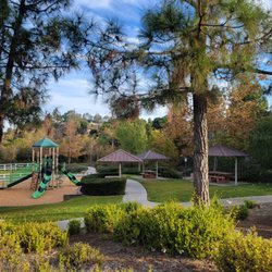
Parks for Kids in Valley Center, California
Watch Sunset in Valley Center, California
Walking Trails in Valley Center, California
Water Parks in Valley Center, California
Waterfalls and Swimming Holes in Valley Center, California
Shaded Hike in Valley Center, California
Secluded Spots in Valley Center, California
Places to Take Pictures in Valley Center, California
Trending Searches in Valley Center, CA
Baseball Fields near Hellhole Canyon County Preserve
Botanical Gardens near Hellhole Canyon County Preserve
Bounce House Rentals near Hellhole Canyon County Preserve
Campgrounds near Hellhole Canyon County Preserve
Cherry Picking near Hellhole Canyon County Preserve
Cliff Jumping near Hellhole Canyon County Preserve
Dog Friendly Things To Do near Hellhole Canyon County Preserve
Fishing Spots near Hellhole Canyon County Preserve
Flower Fields near Hellhole Canyon County Preserve
Flower Shop near Hellhole Canyon County Preserve
Garage Sales near Hellhole Canyon County Preserve
Garden Center near Hellhole Canyon County Preserve
Hair near Hellhole Canyon County Preserve
Lakes & Ponds near Hellhole Canyon County Preserve
Nurseries & Gardening near Hellhole Canyon County Preserve
Outdoor Activities near Hellhole Canyon County Preserve
Outdoor Basketball Courts near Hellhole Canyon County Preserve
Outdoor Furniture Stores near Hellhole Canyon County Preserve
Parks near Hellhole Canyon County Preserve
Party Equipment Rentals near Hellhole Canyon County Preserve
Pedicure near Hellhole Canyon County Preserve
Photo Spots near Hellhole Canyon County Preserve
Pick Your Own Farms near Hellhole Canyon County Preserve
Picnic Areas near Hellhole Canyon County Preserve
Places To Take Pictures near Hellhole Canyon County Preserve
Public Beaches near Hellhole Canyon County Preserve
Public Running Track near Hellhole Canyon County Preserve
Rock Quarry near Hellhole Canyon County Preserve
Running Trails near Hellhole Canyon County Preserve
Splash Pad near Hellhole Canyon County Preserve
Strawberry Picking near Hellhole Canyon County Preserve
Sunrise View near Hellhole Canyon County Preserve
Swimming Holes near Hellhole Canyon County Preserve
Table And Chair Rentals near Hellhole Canyon County Preserve
Tennis Courts near Hellhole Canyon County Preserve
Walking Trails near Hellhole Canyon County Preserve
Browse Brands
Related Searches in Valley Center, CA
Affordable Kayak Rental Services in Valley Center, California
Best Fishing Locations and Guides in Valley Center, California
Best Nature Trails for Hiking in Valley Center, California
Best Off Leash Dog Parks in Valley Center, California
Best Parks for Parties and Events in Valley Center, California
Best Places for Horseback Riding in Valley Center, California
Best Water Parks for Kids in Valley Center, California
Best Waterfalls and Swimming Holes in Valley Center, California
Check Out Great Playgrounds in Valley Center, California
Check Out Off Road Trails in Valley Center, California
Discover Baseball Fields Around Valley Center, California
Discover Beautiful Garden Spots in Valley Center, California
Discover Dog Friendly Trails to Explore in Valley Center, California
Discover Fun Toddler Parks in Valley Center, California for Your Little One
Discover Kid Friendly Hiking Trails in Valley Center, California
Discover Lakes & Ponds to Explore in Valley Center, California
Discover Popular Photo Spots in Valley Center, California
Discover Scenic Bike Paths in Valley Center, California
Discover Scenic Mountain Bike Trails Near Valley Center, California
Discover Scenic Waterfall Spots in Valley Center, California
Discover Soccer Fields in Valley Center, California Near You
Discover Top Nature Parks to Visit in Valley Center, California
Discover Top State Parks to Visit in Valley Center, California
Discover Walking Parks in Valley Center, California Near You
Discover a Hiking Trail in Valley Center, California
Discover the Best Beaches in Valley Center, California
Discover the Best Kids Park Spots in Valley Center, California
Discover the Best Night Hike Trails in Valley Center, California
Discover the Best Running Track in Valley Center, California
Dog-Friendly Hikes With Dogs in Valley Center, California
Enjoy Camping Adventures Around Valley Center, California
Enjoy Exciting Mountain Biking Adventures in Valley Center, California
Enjoy Kayaking Adventures in Valley Center, California
Enjoy Tent Camping Spots Around Valley Center, California
Enjoy a Beautiful Waterfall Hike in Valley Center, California
Enjoy the Best Picnic Spots and Ideas in Valley Center, California
Enjoy the Best Walking Path in Valley Center, California
Enjoy the Best Walking Trails in Valley Center, California
Exciting Cliff Jumping Spots in Valley Center, California
Explore Beautiful Parks and Green Spaces in Valley Center, California
Explore Easy Hikes Perfect for All in Valley Center, California
Explore Family-Friendly Zoos and Wildlife in Valley Center, California
Explore Free Picnic Areas Around Valley Center, California
Explore Fun Activities to Do in Valley Center, California
Explore Parks With Pull Up Bars in Valley Center, California
Explore Popular Campgrounds Near Valley Center, California
Explore Popular Picnic Areas Around Valley Center, California
Explore Popular RV Parks Around Valley Center, California
Explore Popular Recreation Centers Around Valley Center, California
Browse Articles
People who viewed Hellhole Canyon County Preserve also viewed
Elfin Forest Recreational Reserve
233 reviews
Lakeview Trail
6 reviews
Daley Ranch
112 reviews
Lake Hodges Reservoir
65 reviews
Volcan Mountain Preserve
87 reviews
Double Peak Park
181 reviews
Santa Ysabel Open Space Preserve West
13 reviews
Palomar Mountain State Park
91 reviews
Hellers Bend Preserve Trail
4 reviews
Dixon Lake
117 reviews