Adams Park Photos


You might also consider
More like Adams Park
Recommended Reviews - Adams Park
Start your review...

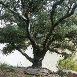
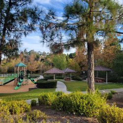
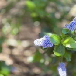
This is a pretty, small, quiet park. I do know there is a history of teens doing things here that they shouldn't be doing, but that was years ago, so hopefully that has stopped. The park is beautiful, filled with grass and old trees, but the grass and weeds are a bit overgrown (maybe because of lots of recent rain), and the paved pathway definitely needs to be re-paved in some areas. There is a small plastic playground for children, and there are grills for people to use, but again, not in the best spots because the grass is growing up on them. There are tennis courts here, a volleyball court (on grass), and a pool, but it looks like you have to pay to swim. There are restrooms here in a brick building, inside the gated park. read more


1 year ago
More info about Adams Park
You might also consider


Adams Park - parks - Updated May 2026
Best of Valley Center
People found Adams Park by searching for…
Playgrounds in Valley Center, CA
Volleyball Courts in Valley Center, CA
Things to Do in Valley Center, CA
Places to Take Pictures in Valley Center, CA
Tennis Courts in Valley Center, CA
Things to Do at Night in Valley Center, CA
Swimming Lakes in Valley Center, CA
Walking Trails in Valley Center, CA
Running Tracks Open to the Public in Valley Center, CA
Running Trails in Valley Center, CA
Picnic Areas in Valley Center, CA
View Points in Valley Center, CA
Flower Fields in Valley Center, CA
Parks With Shade in Valley Center, CA
Photo Spots in Valley Center, CA
Bike Paths in Valley Center, CA
Free Things to Do With Kids in Valley Center, CA
Jogging Trails in Valley Center, CA
Public Indoor Tennis Courts in Valley Center, CA
Trending Searches in Valley Center, CA
Baseball Fields near Adams Park
Botanical Gardens near Adams Park
Bounce House Rentals near Adams Park
Cherry Picking near Adams Park
Nurseries & Gardening near Adams Park
Outdoor Activities near Adams Park
Outdoor Basketball Courts near Adams Park
Outdoor Furniture Stores near Adams Park
Parks For Parties near Adams Park
Party Equipment Rentals near Adams Park
Places To Take Pictures For Prom near Adams Park
Public Running Track near Adams Park
Swimming Holes near Adams Park
Browse Articles
Browse Nearby
BEST of Valley Center, California Coffee near Adams Park
BEST of Valley Center, California Restaurants near Adams Park
BEST of Valley Center, California Things to Do near Adams Park
BEST of Valley Center, California Playgrounds near Adams Park
BEST of Valley Center, California Breakfast near Adams Park
BEST of Valley Center, California Picnic Areas near Adams Park
BEST of Valley Center, California Campgrounds near Adams Park
BEST of Valley Center, California Natural Hot Springs near Adams Park
Browse Brands
Related Searches in Valley Center, CA
Best Nature Trails for Hiking in Valley Center, California
Best Off Leash Dog Parks in Valley Center, California
Best Parks for Parties and Events in Valley Center, California
Best Water Parks for Kids in Valley Center, California
Check Out Great Playgrounds in Valley Center, California
Discover Baseball Fields Around Valley Center, California
Discover Beautiful Garden Spots in Valley Center, California
Discover Fun Children's Playgrounds in Valley Center, California
Discover Fun Toddler Parks in Valley Center, California for Your Little One
Discover Lakes & Ponds to Explore in Valley Center, California
Discover Popular Photo Spots in Valley Center, California
Discover Scenic Bike Paths in Valley Center, California
Discover Soccer Fields in Valley Center, California Near You
Discover Top Nature Parks to Visit in Valley Center, California
Discover Top State Parks to Visit in Valley Center, California
Discover Walking Parks in Valley Center, California Near You
Discover the Best Beaches in Valley Center, California
Discover the Best Kids Park Spots in Valley Center, California
Enjoy the Best Picnic Spots and Ideas in Valley Center, California
Enjoy the Best Walking Trails in Valley Center, California
Explore Easy Hikes Perfect for All in Valley Center, California
Explore Family-Friendly Zoos and Wildlife in Valley Center, California
Explore Free Picnic Areas Around Valley Center, California
Explore Fun Activities to Do in Valley Center, California
Explore Parks With Pull Up Bars in Valley Center, California
Explore Popular Campgrounds Near Valley Center, California
Explore Popular Picnic Areas Around Valley Center, California
Explore Popular RV Parks Around Valley Center, California
Explore Popular Recreation Centers Around Valley Center, California
Explore Scenic Lakes to Visit in Valley Center, California
Explore Top Dog Parks in Valley Center, California Near You
Explore Top Water Parks in Valley Center, California Today
Explore the Best Trail Options in Valley Center, California
Find Parks and Recreation Activities in Valley Center, California
Find Top Dog Friendly Parks to Visit in Valley Center, California
Find Top Skate Parks in Valley Center, California for All Skill Levels
Find the Best Parks BBQ Grills in Valley Center, California
Find the Best Parks for Picnics in Valley Center, California
Have Fun at a Splash Pad in Valley Center, California
Locate Tennis Courts Around Valley Center, California
Parks With Basketball Courts for Games in Valley Center, California
Picnic Areas With BBQ Pits Available in Valley Center, California
Play at a Splash Pad Park in Valley Center, California
Popular Outdoor Activities to Try in Valley Center, California
Popular Places to Take Pictures in Valley Center, California
Top Hiking Trails to Explore in Valley Center, California
Top Running Trails to Explore in Valley Center, California
Top Swimming Lakes to Enjoy in Valley Center, California