La Orilla Trail Photos


You might also consider
More like La Orilla Trail
Recommended Reviews - La Orilla Trail
Start your review...

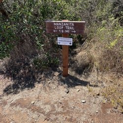
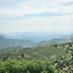
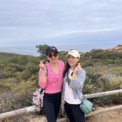
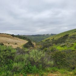
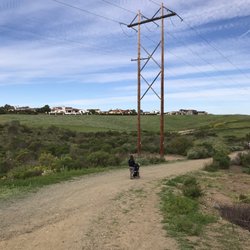
Very limited parking, but you can usually find street parking nearby. The walk/hike is easy. It's about 2 miles out and back with roughly 125 feet of elevation gain. The trail offers some nice views along the way. A few sections are pretty narrow, so you may need to step aside if others are passing. Overall, it's a nice spot for a quick and easy walk. read more


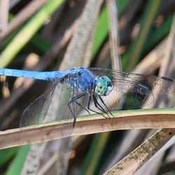
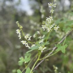
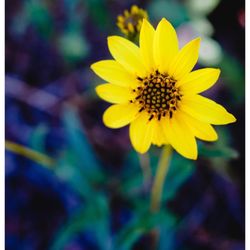
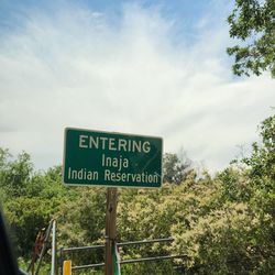
Located in Rancho Santa Fe near Del Mar. it's one of the most beautiful easy trails and good for dogs. You will hike through forest and mostly sandy and dirt trail so bring those gators. Brought my sisters malti poo and he loved it. I saw 7-10 dogs along the way. The parking area can hold maybe 10 cars. The greener is more beautiful in spring and summer. You will part of elijo lagoon. Not much elevation at all. We did appromately 2 miles there and back. read more


More info about La Orilla Trail
16398 El Camino Real
Rancho Santa Fe, CA 92091
Directions
Hours
Outdoor Amenities
You might also consider


La Orilla Trail - hiking - Updated May 2026
Best of Rancho Santa Fe
People found La Orilla Trail by searching for…
Hiking Trails in Rancho Santa Fe, CA
Walking Trails in Rancho Santa Fe, CA
Fun Things to Do in Rancho Santa Fe, CA
Easy Hikes in Rancho Santa Fe, CA
Places to Walk in Rancho Santa Fe, CA
Free Things to Do in Rancho Santa Fe, CA
Things to Do Today in Rancho Santa Fe, CA
Shaded Hike in Rancho Santa Fe, CA
Things to Do at Night in Rancho Santa Fe, CA
Night Walk in Rancho Santa Fe, CA
Running Trails in Rancho Santa Fe, CA
Off Road Trails in Rancho Santa Fe, CA
Bike Paths in Rancho Santa Fe, CA
Walking Groups in Rancho Santa Fe, CA
Stroller Friendly Hikes in Rancho Santa Fe, CA
Beautiful Views in Rancho Santa Fe, CA
Waterfalls in Rancho Santa Fe, CA
Places to Walk at Night in Rancho Santa Fe, CA
Pump Track in Rancho Santa Fe, CA
Fall Foliage in Rancho Santa Fe, CA
Trending Searches in Rancho Santa Fe, CA
Boat Rental near La Orilla Trail
Botanical Gardens near La Orilla Trail
Bounce House Rentals near La Orilla Trail
Campgrounds near La Orilla Trail
Cherry Picking near La Orilla Trail
Cliff Jumping near La Orilla Trail
Dog Friendly Things To Do near La Orilla Trail
Dog Friendly Trails near La Orilla Trail
Flower Fields near La Orilla Trail
Flower Shop near La Orilla Trail
Free Picnic Areas near La Orilla Trail
Garage Sales near La Orilla Trail
Lakes & Ponds near La Orilla Trail
Lookout Points near La Orilla Trail
Nurseries & Gardening near La Orilla Trail
Outdoor Activities near La Orilla Trail
Outdoor Furniture Stores near La Orilla Trail
Party Equipment Rentals near La Orilla Trail
Pick Your Own Farms near La Orilla Trail
Picnic Areas near La Orilla Trail
Places To Take Pictures near La Orilla Trail
Running Trails near La Orilla Trail
Scenic Drive near La Orilla Trail
Scenic Night View near La Orilla Trail
Secluded Spots near La Orilla Trail
Secret Spots near La Orilla Trail
Star Gazing near La Orilla Trail
Strawberry Picking near La Orilla Trail
Sunrise View near La Orilla Trail
Swimming Holes near La Orilla Trail
Table And Chair Rentals near La Orilla Trail
Walking Trails near La Orilla Trail
Browse Nearby
BEST of Rancho Santa Fe, California Coffee near La Orilla Trail
BEST of Rancho Santa Fe, California Restaurants near La Orilla Trail
BEST of Rancho Santa Fe, California Things to Do near La Orilla Trail
BEST of Rancho Santa Fe, California Walking Trails near La Orilla Trail
BEST of Rancho Santa Fe, California Breakfast near La Orilla Trail
BEST of Rancho Santa Fe, California Parks near La Orilla Trail
BEST of Rancho Santa Fe, California Hotels near La Orilla Trail
Browse Brands
Related Searches in Rancho Santa Fe, CA
Affordable Bike Repair Services in Rancho Santa Fe, California
Affordable Bike Tune Up Services in Rancho Santa Fe, California
Affordable Kayak Rental Services in Rancho Santa Fe, California
Affordable Mobile Bike Repair in Rancho Santa Fe, California
Affordable Road Bike Rental in Rancho Santa Fe, California
Best Electric Bike Rental Services in Rancho Santa Fe, California
Best Fishing Locations and Guides in Rancho Santa Fe, California
Best Places for Horseback Riding in Rancho Santa Fe, California
Best Sledding Spots and Fun in Rancho Santa Fe, California
Best Used Bikes for Sale Near Rancho Santa Fe, California
Best Waterfalls and Swimming Holes in Rancho Santa Fe, California
Check Out Off Road Trails in Rancho Santa Fe, California
Discover Dog Friendly Trails to Explore in Rancho Santa Fe, California
Discover Popular Bike Tours in Rancho Santa Fe, California
Discover Popular Bike Trails in Rancho Santa Fe, California
Discover Scenic Bike Paths in Rancho Santa Fe, California
Discover Scenic Hiking Trails in Rancho Santa Fe, California
Discover Scenic Mountain Bike Trails Near Rancho Santa Fe, California
Discover Walking Parks in Rancho Santa Fe, California Near You
Discover a Hiking Trail in Rancho Santa Fe, California
Discover the Best Night Hike Trails in Rancho Santa Fe, California
Dog-Friendly Hikes With Dogs in Rancho Santa Fe, California
Enjoy Biking Adventures Around Rancho Santa Fe, California
Enjoy Camping Adventures Around Rancho Santa Fe, California
Enjoy Exciting Mountain Biking Adventures in Rancho Santa Fe, California
Enjoy Hiking Adventures in Rancho Santa Fe, California
Enjoy Kayaking Adventures in Rancho Santa Fe, California
Enjoy Tent Camping Spots Around Rancho Santa Fe, California
Enjoy a Beautiful Waterfall Hike in Rancho Santa Fe, California
Enjoy the Best Picnic Spots and Ideas in Rancho Santa Fe, California
Enjoy the Best Tubing Experiences in Rancho Santa Fe, California
Enjoy the Best Walking Path in Rancho Santa Fe, California
Enjoy the Best Walking Trails in Rancho Santa Fe, California
Exciting Cliff Jumping Spots in Rancho Santa Fe, California
Explore BMX Bike Shops Near Rancho Santa Fe, California
Explore Beautiful Parks and Green Spaces in Rancho Santa Fe, California
Explore Bike Rentals Throughout Rancho Santa Fe, California
Explore Easy Hikes Perfect for All in Rancho Santa Fe, California
Explore Electric Bikes Available in Rancho Santa Fe, California
Explore Fun Activities to Do in Rancho Santa Fe, California
Explore Popular Campgrounds Near Rancho Santa Fe, California
Explore Popular Scenic Overlook Points in Rancho Santa Fe, California
Explore Scenic Lakes to Visit in Rancho Santa Fe, California
Explore Secret Spots Worth Visiting in Rancho Santa Fe, California
Explore the Best Beach Spots in Rancho Santa Fe, California
Explore the Best Swimming Holes Around Rancho Santa Fe, California
Explore the Best Trail Options in Rancho Santa Fe, California
Family Friendly Hiking With Kids in Rancho Santa Fe, California
Browse Articles
People who viewed La Orilla Trail also viewed
San Elijo Lagoon Ecological Reserve
91 reviews
Tecolote Canyon Natural Park & Nature Center
86 reviews
Linda Vista, Bay Park
Rancho La Costa Preserve
3 reviews
Cleveland National Forest
35 reviews
Seagrove Park
78 reviews
Los Peñaquitos Canyon Del Mar Mesa
2 reviews
Torrey Hills
Rancho La Costa Ridgeline Trail
3 reviews
Big Laguna Trail
3 reviews
Iron Mountain
509 reviews
Lakeview Trail
6 reviews