Maple Canyon Trail Photos


You might also consider


More like Maple Canyon Trail
Recommended Reviews - Maple Canyon Trail
Start your review...


Reviews With Photos


Maple Canyon Trail is located in Bankers Hill area of San Diego. I was looking for an easy trail that would accommodate everyone. This was recommended on Hidden San Diego site and also marked on AllTrails app was "easy". Maple Canyon Trail is dirt (and soft) - so it's harder to walk on for folks that might be a little physically challenged). We started on the Quince Street side (we put 428 Quince Street into Google Maps and it'll bring you to Quince Street Trestle (footbridge). Street Parking. Once you get past the bridge, take a right and the trail starts (on the right side with a warning sign of rattlesnakes). The initial part of the trail was steep to get down onto the trail. Once at the bottom, it is relatively flat for about a mile. Based on this steep part, I would probably say "medium" difficulty. View-wise, some cool big tree trunks. Cool houses to look at (i.e. houses with backyards where owners put their own trails to connect to the Maple Canyon Trail). - More info: https://hiddensandiego.net/things-to-do/places/maple-canyon If you want to skip the steep part on the trailhead and okay to walk on the dirt trail, then start on the 3rd Avenue side. Once you get to the end of the trail, you can loop back. The 3rd Avenue side has some construction (looks like an apartment building is being built). Street Parking as well. - More info: https://www.alltrails.com/trail/us/california/maple-canyon-trail We also got to see a few guys on mountain bikes go down the steep part of the trail on Quince Street side. Experienced guys went down easily. The less experienced guys stopped a few times during the turns to walk their bikes. Pretty neat to watch!! ENJOY!!


San Diego has so many natural secret trails that are breath taking 365 days of the year. Even when it rains in Southern California the ground and dirt is easy to run atop. If you are seeking a nature trail, in the middle of the city, that is a quick motivator and quiet, Maple Canyon can deliver. Easy terrain for biking, jogging, walking pets and holding hands. All ages can enjoy the flat easy 1.6 mile turnaround and little toddlers scramble with joy and exploration. Those of us that live in the community love this trail. Please clean up after your pets and respect our community.
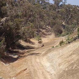

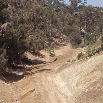
I used to enjoy walking this trail. However the trail is closed now as they are building in this canyon. This will be condos when it is finished and there will be no trail, it's closed.


Great hike with kids, lots of fun things to explore like this giant tree! The path is pretty flat except for the entrance where you go down a dirt path on the foot of the bridge. It doesn't loop so when you end at the residential area, walking back to your car through the hilly street was actually harder than just turning around and going back on the trail.


Great trail nestled in Banker's Hill. It is rather short. Walking slow, you should be able to go down (or up) and back in 45 minutes or so. It is beautiful canyon and feels quite naturey for being right in the city! Neither end of the trail has a great parking situation. You will be parking on the street in the neighborhood, but Google Maps can help you get your car to either end. I am thankful for this little spot. It's a nice substitute from walking throughout the neighborhood/Balboa Park-- though those areas are beautiful, too!


This is a very cool trail not well known except for the locals. I checked it out on a Sunday morning and it was being lightly traveled. The trail is cool because you can start at one end of town and end up at another. I started on third, went across the wooden bridge, took a right and quickly found the steep wooden stairs and dirt path heading down to the approximate 2 mile trail. The path heading down can be a little slippery so were appropriate shoes or be careful. The trail eventually turned into Maple St. and T-boned State St. near W. Laural St., but nor before I could enjoy a scenic natural patch in the middle of the city. I enjoyed the trail with its mix of indigenous and non native plants, such as the large mature Date Palms that certainly stand out from the beginning of the trail on third and and Quince. The trail is completely worn dirt and has a seasonal stream that runs along it. The trail is ideal for walking the pouch on a leash or course. My plan was to walk down to State street, find a place to get some eat and then walk back up, which I did. I thought it was a good plan.


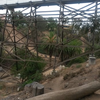
Great little trail in the middle of the city. Wide trail, beautiful foliage, cool under-bridge. Two entrances...we took the one at the end of Maple St.


Great urban trail for a nice stroll with your dogs or little ones. I work one block from the Quince trailhead and never knew this was here. I always assumed this canyon was filled with rattlesnakes, rodents, skunks and maybe even a coyote or bobcat. However, it's really not... The only wild life we saw was a bunch of squirrels. We parked on Fourth by the Quince St. bridge and walked over the bridge. Once you reach the other side of the bridge (on Third), turn right and you'll see the path on your right. You head down to the bottom and walk for about 3/4 of a mile. At the end, you can either turn around or walk up through the neighborhood, which we chose. You end up at the Spruce St. suspension bridge and then you'll only a few blocks from where you started. The whole thing was 2 miles and my fitbit claimed we went up 20 flights of stairs. So it's not an epically long hike, but perfect if you want a quick workout in a central location.


A pretty small trail but irs a great location. You get a good view on the bankers hill area and its very peaceful. Its great for a power stroll and offers good incline distances. If your looking to explore the natural beauty of bankers hill or just want to get a good cardio workout in without heading out of downtown, this is a good trail to do it.


2 months ago
Maple Canyon Trail is a sweet urban joy, and I love stopping here after work for an easy stroll. This trail begins at the end of a residential street that's very limited for parking - but I usually find a spot, It's quite different after renovation over the past two years. It's less quaint, but maybe safer terrain. The trail is much wider, the logs for having a break or climbing are gone, they replaced the bridges, and they've installed terracing with decorative concrete blocks where the creek runs in spring. I think it's flowing underground so those areas are now managed to avoid soggy earth? I love this spot in spring, so we'll see if the daisies and nasturtiums return. It's fun to get a glimpse of planes landing at the airport while having a walk through the canyon. The trail goes under the First Street bridge and the Quince Street bridge. I love hearing the birds in this space. Last night my Merlin Bird app picked up the typical, plus wrens, oriole, munia, towhee, and more. read more


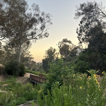


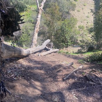
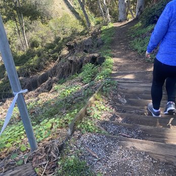


San Diego has many urban canyons, and this short trail happens to wind through the Bankers Hill neighborhood. The south trailhead was a block north of Laurel Street on the east side of I-5 near the off-site airport parking structures. Curbside parking on Maple Street was narrow and difficult to find. The trail was a brief half mile out and back winding north and east until you reach the Quince Street Bridge where the north trailhead was located. The dirt path was very wide and for the most part not steep. You come across an interesting set of cacti right before you pass beneath the First Avenue Bridge. As you look up at the steel girders, you can appreciate the engineering it took to create the structure. On the other hand, the Quince Street Bridge at the north end was made of wood to support a pedestrian walkway. It took less than 30 minutes to complete the back and forth. If you live nearby, the Maple Canyon Trail is a leisurely stroll where you can bring kids and dogs without difficulty for them. For those seeking a more challenging trek, other local urban hikes can fit the bill. read more


Maple Canyon Trail is located in Bankers Hill area of San Diego. I was looking for an easy trail that would accommodate everyone. This was recommended on Hidden San Diego site and also marked on AllTrails app was "easy". Maple Canyon Trail is dirt (and soft) - so it's harder to walk on for folks that might be a little physically challenged). We started on the Quince Street side (we put 428 Quince Street into Google Maps and it'll bring you to Quince Street Trestle (footbridge). Street Parking. Once you get past the bridge, take a right and the trail starts (on the right side with a warning sign of rattlesnakes). The initial part of the trail was steep to get down onto the trail. Once at the bottom, it is relatively flat for about a mile. Based on this steep part, I would probably say "medium" difficulty. View-wise, some cool big tree trunks. Cool houses to look at (i.e. houses with backyards where owners put their own trails to connect to the Maple Canyon Trail). - More info: https://hiddensandiego.net/things-to-do/places/maple-canyon If you want to skip the steep part on the trailhead and okay to walk on the dirt trail, then start on the 3rd Avenue side. Once you get to the end of the trail, you can loop back. The 3rd Avenue side has some construction (looks like an apartment building is being built). Street Parking as well. - More info: https://www.alltrails.com/trail/us/california/maple-canyon-trail We also got to see a few guys on mountain bikes go down the steep part of the trail on Quince Street side. Experienced guys went down easily. The less experienced guys stopped a few times during the turns to walk their bikes. Pretty neat to watch!! ENJOY!! read more


San Diego has so many natural secret trails that are breath taking 365 days of the year. Even when it rains in Southern California the ground and dirt is easy to run atop. If you are seeking a nature trail, in the middle of the city, that is a quick motivator and quiet, Maple Canyon can deliver. Easy terrain for biking, jogging, walking pets and holding hands. All ages can enjoy the flat easy 1.6 mile turnaround and little toddlers scramble with joy and exploration. Those of us that live in the community love this trail. Please clean up after your pets and respect our community. read more


2 years ago
I used to enjoy walking this trail. However the trail is closed now as they are building in this canyon. This will be condos when it is finished and there will be no trail, it's closed. read more

4 years ago
Great hike with kids, lots of fun things to explore like this giant tree! The path is pretty flat except for the entrance where you go down a dirt path on the foot of the bridge. It doesn't loop so when you end at the residential area, walking back to your car through the hilly street was actually harder than just turning around and going back on the trail. read more


4 years ago

Great trail nestled in Banker's Hill. It is rather short. Walking slow, you should be able to go down (or up) and back in 45 minutes or so. It is beautiful canyon and feels quite naturey for being right in the city! Neither end of the trail has a great parking situation. You will be parking on the street in the neighborhood, but Google Maps can help you get your car to either end. I am thankful for this little spot. It's a nice substitute from walking throughout the neighborhood/Balboa Park-- though those areas are beautiful, too! read more


This is a very cool trail not well known except for the locals. I checked it out on a Sunday morning and it was being lightly traveled. The trail is cool because you can start at one end of town and end up at another. I started on third, went across the wooden bridge, took a right and quickly found the steep wooden stairs and dirt path heading down to the approximate 2 mile trail. The path heading down can be a little slippery so were appropriate shoes or be careful. The trail eventually turned into Maple St. and T-boned State St. near W. Laural St., but nor before I could enjoy a scenic natural patch in the middle of the city. I enjoyed the trail with its mix of indigenous and non native plants, such as the large mature Date Palms that certainly stand out from the beginning of the trail on third and and Quince. The trail is completely worn dirt and has a seasonal stream that runs along it. The trail is ideal for walking the pouch on a leash or course. My plan was to walk down to State street, find a place to get some eat and then walk back up, which I did. I thought it was a good plan. read more


11 years ago
Great urban trail for a nice stroll with your dogs or little ones. I work one block from the Quince trailhead and never knew this was here. I always assumed this canyon was filled with rattlesnakes, rodents, skunks and maybe even a coyote or bobcat. However, it's really not... The only wild life we saw was a bunch of squirrels. We parked on Fourth by the Quince St. bridge and walked over the bridge. Once you reach the other side of the bridge (on Third), turn right and you'll see the path on your right. You head down to the bottom and walk for about 3/4 of a mile. At the end, you can either turn around or walk up through the neighborhood, which we chose. You end up at the Spruce St. suspension bridge and then you'll only a few blocks from where you started. The whole thing was 2 miles and my fitbit claimed we went up 20 flights of stairs. So it's not an epically long hike, but perfect if you want a quick workout in a central location. read more


A pretty small trail but irs a great location. You get a good view on the bankers hill area and its very peaceful. Its great for a power stroll and offers good incline distances. If your looking to explore the natural beauty of bankers hill or just want to get a good cardio workout in without heading out of downtown, this is a good trail to do it. read more



8 years ago

6 years ago

9 years ago

A trail for everyone. 16 of us were picking up trash with Giselle's Pledge and I Love A Clean San Diego and besides the 2 who lived in the area, none of us had ever been here. The dirt trail is big enough to share for walkers with and without dogs, runners (watch out for those ruts left by the rain though) and mountain cyclists (they usually come from 1st street because coming from maple/state would be an uphill climb). Most of the trash (and there was nearly 80lbs of it that we collected over 2hrs-we ran out of trash bags) was off the trail in the ravines. Based on the type of things we found - It has/is clearly home for some folks. The trail goes under the 1st street bridge which is a lot of yellow steel from below. There are no picnic tables or rest areas so it's not a park per sw, but a cool urban trail. And I loved some of the homes or cabins that seemingly appear out of nowhere in the canyon. read more


10 years ago

10 years ago
More info about Maple Canyon Trail
3RD Ave
San Diego, CA 92103
Banker's Hill
Directions
Hours
Outdoor Amenities
Ask the Community - Maple Canyon Trail
Review Highlights - Maple Canyon Trail
You might also consider

























Why does Yelp recommend reviews?
1 review that is not currently recommended
The reviews below are not factored into the business's overall star rating.

4 years ago
Maple Canyon Trail - hiking - Updated September 2026
Best of San Diego
People found Maple Canyon Trail by searching for…
Hiking Trails in San Diego, CA
Running Trails in San Diego, CA
Places to Walk in San Diego, CA
Walking Trails in San Diego, CA
Natural Hot Springs in San Diego, CA
Stairs Workout in San Diego, CA
Off Leash Dog Hiking Trails in San Diego, CA
Running Stairs in San Diego, CA
Dog Friendly Hiking Trails in San Diego, CA
Hiking With Kids in San Diego, CA
Make Out Spot in San Diego, CA
Trending Searches in San Diego, CA
Apple Orchards near Maple Canyon Trail
Apple Picking near Maple Canyon Trail
Archery near Maple Canyon Trail
Barbershop near Maple Canyon Trail
Baseball Fields near Maple Canyon Trail
Beautiful Views near Maple Canyon Trail
Blow Dry Bar near Maple Canyon Trail
Corn Maze near Maple Canyon Trail
Dog Friendly Things To Do near Maple Canyon Trail
Dog Parks near Maple Canyon Trail
Dog Swimming near Maple Canyon Trail
Eyelash Extensions near Maple Canyon Trail
Haunted Houses near Maple Canyon Trail
Hiking near Maple Canyon Trail
Hiking Trails near Maple Canyon Trail
Kids Birthday Party near Maple Canyon Trail
Makeup Artists near Maple Canyon Trail
Off Road Trails near Maple Canyon Trail
Outdoor Activities near Maple Canyon Trail
Photo Spots near Maple Canyon Trail
Picnic Areas near Maple Canyon Trail
Places To Take Pictures near Maple Canyon Trail
Playgrounds near Maple Canyon Trail
Private Schools near Maple Canyon Trail
Public Running Track near Maple Canyon Trail
Public Shower near Maple Canyon Trail
Public Tennis Courts near Maple Canyon Trail
Pumpkin Patches near Maple Canyon Trail
Rock Quarry near Maple Canyon Trail
Scenic Night View near Maple Canyon Trail
Scenic Overlook near Maple Canyon Trail
Browse Articles
Browse Nearby
BEST of San Diego, California Restaurants near Maple Canyon Trail
BEST of San Diego, California Coffee near Maple Canyon Trail
BEST of San Diego, California Things to Do near Maple Canyon Trail
BEST of San Diego, California Walking Trails near Maple Canyon Trail
BEST of San Diego, California Breakfast near Maple Canyon Trail
BEST of San Diego, California Parks near Maple Canyon Trail
BEST of San Diego, California Campgrounds near Maple Canyon Trail
BEST of San Diego, California Caves near Maple Canyon Trail
BEST of San Diego, California Sightseeing near Maple Canyon Trail
Browse Brands
Related Searches in San Diego, CA
Affordable Kayak Rental Services in San Diego, California
Best Dog Hiking Trails Around San Diego, California
Best Fishing Locations and Guides in San Diego, California
Best Nature Trails for Hiking in San Diego, California
Best Off Leash Dog Parks in San Diego, California
Best Parks for Parties and Events in San Diego, California
Best Places for Horseback Riding in San Diego, California
Best Sightseeing Experiences Available in San Diego, California
Best Water Parks for Kids in San Diego, California
Check Out Great Playgrounds in San Diego, California
Check Out Off Road Trails in San Diego, California
Discover Baseball Fields Around San Diego, California
Discover Dog Friendly Trails to Explore in San Diego, California
Discover Easy Hiking Trails Near San Diego, California
Discover Fun Toddler Parks in San Diego, California for Your Little One
Discover Kid Friendly Hiking Trails in San Diego, California
Discover Lakes & Ponds to Explore in San Diego, California
Discover Popular Bike Trails in San Diego, California
Discover Scenic Mountain Bike Trails Near San Diego, California
Discover Soccer Fields in San Diego, California Near You
Discover Top Nature Parks to Visit in San Diego, California
Discover Top State Parks to Visit in San Diego, California
Discover Walking Parks in San Diego, California Near You
Discover a Hiking Trail in San Diego, California
Discover the Best Beaches in San Diego, California
Discover the Best Kids Park Spots in San Diego, California
Discover the Best Night Hike Trails in San Diego, California
Dog-Friendly Hikes With Dogs in San Diego, California
Enjoy Camping Adventures Around San Diego, California
Enjoy Kayaking Adventures in San Diego, California
Enjoy Off Leash Dog Hikes in San Diego, California
Enjoy Scenic Places to Walk in San Diego, California
Enjoy Tent Camping Spots Around San Diego, California
Enjoy a Beautiful Waterfall Hike in San Diego, California
Enjoy the Best Picnic Spots and Ideas in San Diego, California
Enjoy the Best Walking Path in San Diego, California
Enjoy the Best Walking Trails in San Diego, California
Explore Beautiful Parks and Green Spaces in San Diego, California
Explore Easy Hikes Perfect for All in San Diego, California
Explore Free Picnic Areas Around San Diego, California
Explore Fun Activities to Do in San Diego, California
Explore Parks With Pull Up Bars in San Diego, California
Explore Picnic Parks Near San Diego, California
Explore Popular Campgrounds Near San Diego, California
Explore Popular Kids Parks Throughout San Diego, California
Explore Popular Picnic Areas Around San Diego, California
Explore Popular RV Parks Around San Diego, California


