
Fortuna Mountain Photos


You might also consider
More like Fortuna Mountain
Recommended Reviews - Fortuna Mountain
Start your review...

Reviews With Photos

This was such a memorable hike. We chose a 6mi route from AllTrails starting at the East Fortuna staging area that took us to South Fortuna ("lowest of the five main peaks in the park"), but on our way back we took the wrong turn and tended up doing a 10+ mile hike. It was so hot that day, and we didn't bring enough water. I don't know what happened, but we somehow went "uphills both ways" because nowhere on this route did we end up going downhill. On (what felt like) the 100th steep upward climb, I asked my partner "Are we going to be those idiots who need to get airlifted out of here?" But we caught our second wind and managed to finish the hike. Overall, we felt very accomplished and deserving of the fried chicken meal we subsequently ate. But seriously, be prepared for multiple steep uphill climbs. Or for some people that seemed to have gone backwards, a very slippery downhill slide. We parked at West Hills Park, because on top of everything else, we got confused on the parking. So this added extra distance to the hike. There is parking at the East Fortuna Staging Area. There also were clean restrooms here

Absolutely love options, I am a variety girl and I get bored with the same old same old. Gotta switch it up. AND this place allows that. This place caters to YOU. I love that Fortuna Mountain lets you be the one who wears the shoes. and I am talking, big ol trail shoes/boots or hey if you're like me and wear vibrams then you with the barefoot look OK. We showed up, dogs knew it was business. Whether you want to keep it chill and just do a 2 mile walk/hike or want to get serious and do 10+ miles, that is ON YOU and we love that for us. We made sure to stay on trail, absolutely YES. Wide walking spaces, for passerby's. Tons of scenic, view points at the top. Lovely weather year round. The map at the front gives you an idea of what trails to take. Plenty of signage throughout and just generally felt safe. There was one trail that was EXTREMELY steep, sketch but that's OK just turn around, don't do that one lol. Basically tons of options and I am here for it. ALSO, huge parking lot for the whole fam to park, no stress, stress-free parking. I can't recall if they had a porter potty or restroom...that is probably the only CON. I hope they put one for us small bladder girlies.

On our first visit to Fortuna, we accidentally went the "backwards" route, meaning we hiked North Peak before hitting South. That was partly due to the construction that blocks a few trails along the way, but mostly due to our ignorance of the trails. That route was fine, but it definitely made for a treacherous trek down South Peak. Some of the steps - rocks, bolted in wooden planks - are taller than me, so I did experience more than a couple pucker moments, trying to stick the landing before traversing the next drop. This set of trails has become our favorite hiking spot, just because there are so many options. You can miss the trail to South Peak as we did on our first trip (tucked along the road on the right-hand side as it is; after crossing the bridge to enter the trails, turn left and you'll see the sign for the easy trail about 1/4 of the way up the incline. Follow that trail and the signs to head towards South Peak), but you'll still have a challenging hike ahead of you. The hike up both Peaks is fairly demanding. I am not ashamed to admit that I often have to pull over to the side to allow other, more fit hikers to pass. I tell myself it's because I need a sip of water, or because I want to admire the view and revel in how far we'd climbed, but no...it's usually because I'm feeling a steep pain at that point and need to rest my weary bones. I personally prefer the North-to-South trail, as it's challenging from start to finish, but my husband prefers the South-to-North option, since that route ends with a gentle descent back to the bridge and the exit. Either way, there are plenty of off-shoot trails that one can take without fear of getting lost. Our typical route (I've included a screen grab of the GPS tracker, so you can see our ~8 mile loop) takes us through some of the less-traveled trails, past a stagnant green pond and up a couple deceptive slopes before looping back on itself to get to the entrance/exit. Quick shout-out to Gordon V's review; we relied on the beginning of his review to figure out where to go on our first trip. Sure, we got lost after I stopped referring to his notes, but really...it didn't impact our trip at all. We'll keep at it, with this trail and our route through these peaks. Eventually, we'll branch out to some of the other trail options but for now, this route challenges and strengthens us every weekend.

This is a great hike with a lot of steps right before you reach the summit. Once you park you walk across the wooden bridge and the signs will point the way. The first turn is to the left if you are hiking to the South or North Peaks. Dirt path, there is also a utility vehicle road which is wider than the trail. There are rattlesnakes, be careful when running I almost slid into one. Sunscreen and lots of water. Once you reach the South Fortuna marker you can take the trail to the left to hike to North Fortuna. It is not far and then you can either backtrack or wrap around the loop to return to the parking lot. There are signs telling you where you are right now, and how to get to the west staging area, or other locations. I would advise putting the Mission Trails Regional Parks phone number in your contacts before you go in case of emergency or you get lost. Enjoy the peaks!

If you are doing north and south Fortuna, bring sunscreen and lots of water. Take a paper map of the trail as there are lots of splits through the trail system. It was beautiful though! A nice break from the city. Parking is tough as there is some construction in the area and there are not a lot of restrooms.

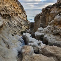
My fave hike in SD county. This park has tonnns of trails. So what seems to be a shitshow down in the 2 parking lots does not reflect the open space you get here compared to other hikes thanks to the many routes people disperse amongst. We came for the South Fortuna trail with the Stairs to Heaven/Hell (depending on your perspective). Right from the onset there is a brief river/creek passing that will require water safe shoes or for you to go barefoot across. Jan 2022, I went barefoot, mostly just toes wet, deepest part beneath my ankle. It was cold but not ice cube cold, it was fine probably thanks to recent warm weather. There are many many dips and climbs on the pursuit of the stairs that give a great challenging workout long before you reach the base of the stairs 3/4 way into the hike. Approaching the stairs the terrain becomes rather smooth and sandy so I highly recommend hiking shoes w good traction. The stairs are a beast and very rocky. Once at the top, just a .5 mile further for the summit. Gorgeous. I'll be here regularly.

I will admit, I have not been able to make it to the top of North Fortuna Mountain, but I do love coming here I have been working my endurance to make it up. I did however like the trails that lead to the base of the mountain. Some areas were maintained with decomposed granite and other trails were weathered and worn by hikers and such. Some trails are designated for mountain bikes. I entered from from the end of Clairemont Mesa Blvd. East at the Mission Trails Clairemont Mesa Trailhead. You can park along the street, the cul-de-sac, or the dirt parking lot at the head of the trail. I would imagine the surrounding area looks a lot better after the rainy season, and I hear it does!

Killer Hike!!! If you want a full body work out, South Fortuna will provide! Yes, you will have to climb the infamous "stairs from hell", to reach the summit, so worth it! The trail we took was an out & back, 4.6 miles. Trail head started near the parking lot located on Jackson Dr./Mission Gorge Rd, by the SD Aqueduct Monitoring & Controls. Prepare to get your feet wet, you will need to cross the San Diego River, which was at 3 feet on 4/4. There is a crossing to the left of the trail you could use. The morning was very foggy and chilly as we headed towards the mountain. By the time we descended, the sun was out in full force and there's not much shade. Make sure you apply plenty of sunblock. Dress in layers, bring enough water (you will need it), and good trail shoes or hiking boots is highly recommended. The terrain is very rocky, with lots of loose gravel. Get up and get out.

I think this is one of the better hikes in Mission trails. Starting from Claremont Dr you can see a variety of great views and get a nice work out (South Fortuna stairs is the most strenuous point and it will get your heart pumping). It is also not as busy as other park trails. If you want a longer hike, you can also extend it to North Fortuna.

This was a pretty challenging hike, especially when you have to ascend the slope on the south side of the peak. I saw several folks having to take breaks along that part of the trail. Trekking poles were helpful for the climb. The view at the summit was not as impressive as the one at Cowles Mountain. At the saddleback, pay attention to the signage as you can easily take the wrong path and end up on the North Fortuna trail. I wanted to take a longer route back, but it turned out that path was more suited for mountain biking as there were numerous bikers to whom I yielded the right of way so they could pass me. Hiking South Fortuna will give you a good workout because of its distance and the contours. Watch out for snakes as I nearly stepped on one as the sucker was making its way out of the bushes and into the sunlight.


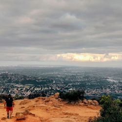
I did North and South Fortuna yesterday on New Years. This was the last of the 5 Peaks in the Mission Trails Park for me to complete since I have previously done Cowles, Kwaay Paay, and Pyle's Peaks. Parking- parked on Claremont Mesa Blvd near Rueda in the west staging area and accessed the trail from the Tierrasanta Entrance and there is a bridge you cross at the entrance Trails- there are many intersecting/connecting trails and you sometimes have the doubt if you are going the right way; the reassuring thing is you can basically see the two peaks at all times since the 2 Fortunas are the 2 peaks farthest North in the park; about a mile into the hike we took a muddy trail down due to the recent storms it was extremely muddy and slippery with large clumps of mud sticking to our shoes and we went down to an elevation of about 500ft according to my Runkeeper app; we then took a steep trail up that took us up to a point that was in between North and South Fortunas with 0.6 miles to either peak and we decided to do the hardest one first and did the North and then did the South and took the same trails back to where we parked and it was 7 miles RT Peaks- the North peak was steeper and had better views (esp. clear after the recent storms) and reached about 1200ft elevation.. .we could clearly see downtown SD and the Pacific Ocean; there were also a couple of boxes with notebooks and pen for you to leave a note/message; the South peak was easier and just a simple sign at the top with less impressive views *there isn't much to look at until you get to the top and keeps this from being a 5 star hike and is closer to a 3.5...I am planning on coming back to do all 5 peaks in the park on one day


The South Fortuna Mountain and Fortuna Saddle Loop is a solid, rewarding hike with a great mix of climbs, views, and a little challenge. I did this loop on a hot day, so definitely plan for early morning or cooler weather--the heat can be intense with very little shade throughout the trail. I started the loop by going left at the trailhead, which means you descend the infamous stairs instead of climbing them. That definitely made it easier on the lungs, but the steep, rocky descent was a bit rough on the knees. Trekking poles would be helpful here if you have sensitive joints. The trail is well-marked, with steady elevation gains, wide open views, and a mix of single-track and wider fire roads. While it's not a heavily trafficked trail--I didn't see too many people--you still feel safe and connected enough in case you need help. There is parking at the trailhead, and it wasn't crowded when I arrived. The loop makes for a great workout and offers beautiful panoramic views from the top, making the effort well worth it. read more


I hiked the north and south portions of this mountain in January 2025, winter. I can absolutely see how beautiful it can get in the Spring if we ever get any rain. This is a popular trail, with many people hiking and their pets. There are areas of exposure and some are shaded. Different types of terrain also to test your technical skills. Absolutely love the "ups" and this one delivers some fun ones. Parking is street and easy at the trailhead. Bring lots of water and some food to enjoy at the peak. Please come so you can create your own experience. read more

1 year ago
Knowing where to enter was the trickiest part to this hike. There are multiple entry points for the Fortuna trails, but I started at Gate 9, right off the road, which led me through the Grasslands, then onto the Oak Canyon Trail, and finally to the Fortuna Saddle Trail, where you could turn right to hike North Fortuna (1,291 ft) or left to hike South Fortuna (1,094 ft). I decided to start with North Fortuna, and at this summit, I arrived just as a man was kneeling to propose. I captured a few photos for them--such a special moment to witness. Both summits are about 1.2 miles out-and-back from the saddle. The full hike was roughly 7 miles round-trip. The trail was beautiful, crossing bridges and water, but also quite steep in sections. Make sure to pack lots of water and snacks as there's not much shade along these hikes. If you're doing the five peak challenge, I recommend starting with the Fortuna hikes or Kwaay hike. read more


This was such a memorable hike. We chose a 6mi route from AllTrails starting at the East Fortuna staging area that took us to South Fortuna ("lowest of the five main peaks in the park"), but on our way back we took the wrong turn and tended up doing a 10+ mile hike. It was so hot that day, and we didn't bring enough water. I don't know what happened, but we somehow went "uphills both ways" because nowhere on this route did we end up going downhill. On (what felt like) the 100th steep upward climb, I asked my partner "Are we going to be those idiots who need to get airlifted out of here?" But we caught our second wind and managed to finish the hike. Overall, we felt very accomplished and deserving of the fried chicken meal we subsequently ate. But seriously, be prepared for multiple steep uphill climbs. Or for some people that seemed to have gone backwards, a very slippery downhill slide. We parked at West Hills Park, because on top of everything else, we got confused on the parking. So this added extra distance to the hike. There is parking at the East Fortuna Staging Area. There also were clean restrooms here read more


3 years ago
Absolutely love options, I am a variety girl and I get bored with the same old same old. Gotta switch it up. AND this place allows that. This place caters to YOU. I love that Fortuna Mountain lets you be the one who wears the shoes. and I am talking, big ol trail shoes/boots or hey if you're like me and wear vibrams then you with the barefoot look OK. We showed up, dogs knew it was business. Whether you want to keep it chill and just do a 2 mile walk/hike or want to get serious and do 10+ miles, that is ON YOU and we love that for us. We made sure to stay on trail, absolutely YES. Wide walking spaces, for passerby's. Tons of scenic, view points at the top. Lovely weather year round. The map at the front gives you an idea of what trails to take. Plenty of signage throughout and just generally felt safe. There was one trail that was EXTREMELY steep, sketch but that's OK just turn around, don't do that one lol. Basically tons of options and I am here for it. ALSO, huge parking lot for the whole fam to park, no stress, stress-free parking. I can't recall if they had a porter potty or restroom...that is probably the only CON. I hope they put one for us small bladder girlies. read more


5 years ago
On our first visit to Fortuna, we accidentally went the "backwards" route, meaning we hiked North Peak before hitting South. That was partly due to the construction that blocks a few trails along the way, but mostly due to our ignorance of the trails. That route was fine, but it definitely made for a treacherous trek down South Peak. Some of the steps - rocks, bolted in wooden planks - are taller than me, so I did experience more than a couple pucker moments, trying to stick the landing before traversing the next drop. This set of trails has become our favorite hiking spot, just because there are so many options. You can miss the trail to South Peak as we did on our first trip (tucked along the road on the right-hand side as it is; after crossing the bridge to enter the trails, turn left and you'll see the sign for the easy trail about 1/4 of the way up the incline. Follow that trail and the signs to head towards South Peak), but you'll still have a challenging hike ahead of you. The hike up both Peaks is fairly demanding. I am not ashamed to admit that I often have to pull over to the side to allow other, more fit hikers to pass. I tell myself it's because I need a sip of water, or because I want to admire the view and revel in how far we'd climbed, but no...it's usually because I'm feeling a steep pain at that point and need to rest my weary bones. I personally prefer the North-to-South trail, as it's challenging from start to finish, but my husband prefers the South-to-North option, since that route ends with a gentle descent back to the bridge and the exit. Either way, there are plenty of off-shoot trails that one can take without fear of getting lost. Our typical route (I've included a screen grab of the GPS tracker, so you can see our ~8 mile loop) takes us through some of the less-traveled trails, past a stagnant green pond and up a couple deceptive slopes before looping back on itself to get to the entrance/exit. Quick shout-out to Gordon V's review; we relied on the beginning of his review to figure out where to go on our first trip. Sure, we got lost after I stopped referring to his notes, but really...it didn't impact our trip at all. We'll keep at it, with this trail and our route through these peaks. Eventually, we'll branch out to some of the other trail options but for now, this route challenges and strengthens us every weekend. read more

 - Hiking Near Me - San Diego, California")


This is a great hike with a lot of steps right before you reach the summit. Once you park you walk across the wooden bridge and the signs will point the way. The first turn is to the left if you are hiking to the South or North Peaks. Dirt path, there is also a utility vehicle road which is wider than the trail. There are rattlesnakes, be careful when running I almost slid into one. Sunscreen and lots of water. Once you reach the South Fortuna marker you can take the trail to the left to hike to North Fortuna. It is not far and then you can either backtrack or wrap around the loop to return to the parking lot. There are signs telling you where you are right now, and how to get to the west staging area, or other locations. I would advise putting the Mission Trails Regional Parks phone number in your contacts before you go in case of emergency or you get lost. Enjoy the peaks! read more


4 years ago
If you are doing north and south Fortuna, bring sunscreen and lots of water. Take a paper map of the trail as there are lots of splits through the trail system. It was beautiful though! A nice break from the city. Parking is tough as there is some construction in the area and there are not a lot of restrooms. read more


My fave hike in SD county. This park has tonnns of trails. So what seems to be a shitshow down in the 2 parking lots does not reflect the open space you get here compared to other hikes thanks to the many routes people disperse amongst. We came for the South Fortuna trail with the Stairs to Heaven/Hell (depending on your perspective). Right from the onset there is a brief river/creek passing that will require water safe shoes or for you to go barefoot across. Jan 2022, I went barefoot, mostly just toes wet, deepest part beneath my ankle. It was cold but not ice cube cold, it was fine probably thanks to recent warm weather. There are many many dips and climbs on the pursuit of the stairs that give a great challenging workout long before you reach the base of the stairs 3/4 way into the hike. Approaching the stairs the terrain becomes rather smooth and sandy so I highly recommend hiking shoes w good traction. The stairs are a beast and very rocky. Once at the top, just a .5 mile further for the summit. Gorgeous. I'll be here regularly. read more

I will admit, I have not been able to make it to the top of North Fortuna Mountain, but I do love coming here I have been working my endurance to make it up. I did however like the trails that lead to the base of the mountain. Some areas were maintained with decomposed granite and other trails were weathered and worn by hikers and such. Some trails are designated for mountain bikes. I entered from from the end of Clairemont Mesa Blvd. East at the Mission Trails Clairemont Mesa Trailhead. You can park along the street, the cul-de-sac, or the dirt parking lot at the head of the trail. I would imagine the surrounding area looks a lot better after the rainy season, and I hear it does! read more


5 years ago
Killer Hike!!! If you want a full body work out, South Fortuna will provide! Yes, you will have to climb the infamous "stairs from hell", to reach the summit, so worth it! The trail we took was an out & back, 4.6 miles. Trail head started near the parking lot located on Jackson Dr./Mission Gorge Rd, by the SD Aqueduct Monitoring & Controls. Prepare to get your feet wet, you will need to cross the San Diego River, which was at 3 feet on 4/4. There is a crossing to the left of the trail you could use. The morning was very foggy and chilly as we headed towards the mountain. By the time we descended, the sun was out in full force and there's not much shade. Make sure you apply plenty of sunblock. Dress in layers, bring enough water (you will need it), and good trail shoes or hiking boots is highly recommended. The terrain is very rocky, with lots of loose gravel. Get up and get out. read more


4 years ago
I think this is one of the better hikes in Mission trails. Starting from Claremont Dr you can see a variety of great views and get a nice work out (South Fortuna stairs is the most strenuous point and it will get your heart pumping). It is also not as busy as other park trails. If you want a longer hike, you can also extend it to North Fortuna. read more


This was a pretty challenging hike, especially when you have to ascend the slope on the south side of the peak. I saw several folks having to take breaks along that part of the trail. Trekking poles were helpful for the climb. The view at the summit was not as impressive as the one at Cowles Mountain. At the saddleback, pay attention to the signage as you can easily take the wrong path and end up on the North Fortuna trail. I wanted to take a longer route back, but it turned out that path was more suited for mountain biking as there were numerous bikers to whom I yielded the right of way so they could pass me. Hiking South Fortuna will give you a good workout because of its distance and the contours. Watch out for snakes as I nearly stepped on one as the sucker was making its way out of the bushes and into the sunlight. read more


I recently visited this trail for the first time and I thought I was an awesome hike. It starts off with a nice warm up walk and out of nowhere you get smacked with steep climbs. It's An amazing workout and a good view, definitely bring some water! read more


I did North and South Fortuna yesterday on New Years. This was the last of the 5 Peaks in the Mission Trails Park for me to complete since I have previously done Cowles, Kwaay Paay, and Pyle's Peaks. Parking- parked on Claremont Mesa Blvd near Rueda in the west staging area and accessed the trail from the Tierrasanta Entrance and there is a bridge you cross at the entrance Trails- there are many intersecting/connecting trails and you sometimes have the doubt if you are going the right way; the reassuring thing is you can basically see the two peaks at all times since the 2 Fortunas are the 2 peaks farthest North in the park; about a mile into the hike we took a muddy trail down due to the recent storms it was extremely muddy and slippery with large clumps of mud sticking to our shoes and we went down to an elevation of about 500ft according to my Runkeeper app; we then took a steep trail up that took us up to a point that was in between North and South Fortunas with 0.6 miles to either peak and we decided to do the hardest one first and did the North and then did the South and took the same trails back to where we parked and it was 7 miles RT Peaks- the North peak was steeper and had better views (esp. clear after the recent storms) and reached about 1200ft elevation.. .we could clearly see downtown SD and the Pacific Ocean; there were also a couple of boxes with notebooks and pen for you to leave a note/message; the South peak was easier and just a simple sign at the top with less impressive views *there isn't much to look at until you get to the top and keeps this from being a 5 star hike and is closer to a 3.5...I am planning on coming back to do all 5 peaks in the park on one day read more


 - Hiking Near Me - San Diego, California")
 - Hiking Near Me - San Diego, California")

5 years ago
Wow! What a great hike! Almost passed out and died 3 times. Highly recommend would definitely do it again but god forbid please do NOT forget to bring water. read more


16 years ago
It's time for Fortuna to be shown some official yelp luv by me. I'm surprised in all these years it's never been added to the database, and that I haven't thought to do it myself. But what surprises me even more is that so many people aren't aware of it's existence- even some avid hikers I've met! Then again, I had never heard of Cabrillo till last weekend so who am I to talk. We will call this redemption, then, as I offer a gem of my hiking knowledge to all those yet to experience this place within Mission Trails I can sum the greatest of this hike into 3 words: South Fortuna Staircase. I don't think that I've ever taken someone on that route who got to the top and said "that was cake." Oh no no...this is a good lil jaunt up 314 unevenly spaced wood beam support stairs to the top (counted after being contacted by a staircase blogger, lol) . When I am in good enough shape I will run up most of them for a bit more craziness. And like most decent inclines, the view at the top is a panoramic masterpiece of all san diego county on a clear day. It sounds odd but the hike leading up to this staircase is one of my favorite activities in San Diego. I've probably done the climb 5 or 6 times now and always feel full of satisfaction and accomplishment which makes my wish I lived in the area to do it every weekend. Once you reach the top of the South side you can continue to climb North Fortuna, cut down the middle to head back, or of course go back down the staircase the way you came. This is a nice aspect of the area because it allows you some variation of distance and difficulty depending on your mood....maybe making it up the staircase without keeling over is enough for the day....or maybe it WAS cake and you want to give the North part a piece of your mind. It was documented on my last climb that the entire loop heading to South Fortuna, over North, and back is about 6.75 miles...and give or take 2 to 2.5 hours to accomplish if you move at a decent pace. The journey has it all: flat area to stroll through fields of wild flowers (during the spring), mild up and downs throughout, and then the good kick in the a$$ official climbing up the mountain. You will sweat. you will consume lots of water (i ran out of my camelbak 3/4 of the way). you will feel the burn. you will leave saying "that was a hike." I guarantee that. It must also be noted that this is a completely chaparral area of mission trails...absolutely no shade to be found. There is a few minutes of shaded green forestry should you chose that path, but otherwise...nadda. DO not do this hike mid afternoon in the summer unless you are crazy and/or seriously prepared with enough water and a cell phone. it's dangerous yo. --- Informational stuff: I posted the website that provides directions to the tierrasanta lot. Super easy...you just take Clairemont Mesa Blvd east till it dead ends. Plenty of parking. MY PREFERRED ROUTE: When you start out on the hike you head left after the bridge, but keep an eye out for the small trail opening on the right to go south east (if you want to get to the staircase). It can be confusing and the beginning signs pointing to "fortuna" direct you to the north access. GPS MAP: http://tinyurl.com/3g4dwrb read more


10 years ago
A more accurate title for this listing would be Fortuna Mountain*s*. Both South and North Fortuna are connected via a saddle back and you can easily complete both during an early morning weekend hike. There are several ways to get to the mountains and summit each. We started from the Clairemont Mesa Blvd. trail head and crossed the bridge over into Mission Trails. I might note that there is a circular dirt lot at this entrance, but also PLENTY of street parking in the adjacent neighborhood. I would rate this hike as moderate - we did 7 miles round trip in about 2-2.5 hours. Most was flat until we reached the South Fortuna steps. It is a little confusing coming up to South Fortuna first since the signage isn't very detailed. Thankfully, some bikers pointed us in the right direction. We ended up hiking through some very skinny trails with a lot of growth, so it's definitely easy to get lost. The steps appeared to us as pure evil and we laughed as the biker's description of them as 'them crazy steps' was beginning to seem very accurate. The steps were brutal and the ultimate stair master, but it was only for a short distance. Once you reach the top, descend into the saddle back, then begin the ascent to the North Fortuna summit, it's cake. More people were coming up North Fortuna from the I-52 side as we were descending, so we were beginning to think we took a harder route. In any case, summitting the two peaks in one trip wasn't that bad at all. As always, bring plenty of sun screen on a hot day since there isn't a lot of shade and equip yourself with some good hiking shoes. The descents killed my knees, but I was also sliding and tripping on rocks often. A solid 4-stars for semi-challenging climbs with great city views. I still yearn for more nature and seclusion though. read more


7 years ago
If you want "Buns of Steel" you have to meet "Stairmaster to Hell". You'll find these torturous stairs on the south side of South Fortuna. I finished out my last two peaks of the 5-Peak Challenge on North and South Fortuna. You can probably say I saved the best for last. The views were awesome both going up and coming down. I did the hike during the weeklong rains and was rewarded with beautiful river currents ebbing downslope and lush green hills. As others have noted, you can get lost or disoriented going up to North Fortuna and some parts of South Fortuna but if you have a trusty app, you shouldn't have much of a problem. Actually, I wouldn't have minded getting lost because it was so rad up there!!!!! Now, I definitely think the stairs leading up to South Fortuna was probably one of the most challenging hikes of all five peaks. After traveling roughly 2 miles of incline, you'll see those stairs heading straight up. No switchbacks here, pretty much a straight shot up. As I was walking up it, my glutes and thighs were taking the brunt of the pain. But since this was the last peak, I welcomed the burn. I recommend taking some pics halfway through the stairs. You'll get nice views of the cliff and if you trek a little further to the side, you'll find the San Diego River along a bike trail by Jackson Drive. Epic. read more


5 years ago
We did it!!! Hiked South Fortuna's "stairway to heaven". Make sure to bring water, little to no shade on the path. A few other people, bikers and dogs but not crowded at all. Good variety of terrain and difficulty. We parked at the visitor center and took the visitor center loop to San Diego river crossing to suycott valley trail to south Fortuna then made it a loop by coming down the Fortuna saddle trail to connect back to suycott trail to San Diego river crossing to visitors loop. Took us about 3hrs, we took our time and brought my dog. Recommend to start early, especially if you want to do both North and South peaks. read more

5 years ago
8 years ago
This review is for the South Fortuna section. Parking is in a small dirt lot or out on the street. This area was not difficult to find parking and the traffic was relatively tame compared to Cowles Mountain and the Northern area of Fortuna. There are a lot of signs and hills connecting to each other on the trails. Although losing your way may happen following the trails and signs kept this to a minimal (surprisingly Google maps worked well out here for my hiking party). We managed to connect to the Northern section of Fortuna and made it to the peak. Immaculate views of the city from here. We found a loop that made it back to the Southern section and the start of the hike. Six plus miles in the books. Mission Trails has a lot of good trails and this is one of them. The hills are very challenging and this is a great workout. Bring your water and hiking gear. You will need it. read more


Double peak hike today! Conquered both South and North Fortuna in one day! If you are going to do one you might as well do both since they connect at the saddle trail junction. The plan was to complete just South Fortuna and after the stair master of hell most would want to finish too! But in completing the loop around to finish the hike we passed the start of the North Fortuna trail it was only 0.6 miles more... on an incline but so worth it! There is a old ammo box at the peak with notebooks and pens. It was interesting to read the messages from people from all over and in different languages. Honestly I would rate both the fortunas moderate to difficult. It all depends on which trail you take to get to each one. The hardest part on South Fortuna is the damn stairs I won't lie that had me out of breath. It starts nice but the stairs start to get more and more eroded as you get up further. Turns into more rocks than stairs. Once you finish the stairs you still need to go in further to get to the peak sign. North Fortuna from here wasn't bad it was an incline though. If you take the trail straight to North I heard it's tougher with a lot of rocks to climb. Each peak has its one major challenging point but other than that it's a moderate hike once again depending on fitness level. I would be careful as well pay attention to the trail markers it's easy to take the wrong trail. It's not a clear back and out trail to reach these peaks. Overall I found both challenging in one main spot the rest of the trail is pretty moderate and flat. Getting back to the car though, we had to hike uphill on the last bit. Good workout! read more


I thought we wouldn't get lost... but we did. We google mapped and I don't think that address is correct. We ended up hiking tierrasanta trail instead of the furtuna trail. I'd recommend googling mission trails regional park, there's a parking lot there (albeit small) and there are clear signs for north and south fortuna summits. We hiked north fortuna instead of South :( but we thought north was cool too! There are geo-caches at the top! read more


9 years ago
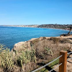
Fortuna Mountain is located at Mission Trails Regional Park in the San Diego area. It has two summits called North Fortuna and South Fortuna. Since we started our day so late, we only made it to the South Fortuna summit. Found the signs for Fortuna Mountain as we were hiking along Oak Canyon trail from the Old Mission Dam. The hike up the Fortuna Saddle trail made for a good cardio workout. It was a steady incline from the start. The last portion of the Saddle trail was steep and challenging. Make sure to step carefully especially if you take the same route down like we did. There are different trails to hike up to each respective summit. Hope to hike all of them in the future. Both North Fortuna and South Fortuna are part of the 5 Peak Challenge at Mission Trails Regional Park. Fortuna Mountain is not the highest or prettiest mountain. Despite all that, I am giving this challenging Fortuna Mountain hike 5 stars! read more


Super awesome trail, recommend doing both North and South Fortuna! Bring plenty of water and maybe even some snacks, as the view from the top is epic! This peak and South Fortuna are part of the 5 peak challenge so make sure to get your photos by the summit signs! North Fortuna has signature notebooks in ammo cans which is freaking cool read more


My favorite part of the Mission Trails Park! You can combine the two peaks into one long hike or conquer them separately from two sides of the park. My review is on the latter. South Fortuna Trail: Start in the Mission Trails Tierrasanta entrance (end of Clairemont Mesa Boulevard, with plenty of parallel parking spots on the road), take the trail down into the first canyon (entrance into the canyon is partially hidden behind a tree but the turnoff is before the first hill on the left side) and follow South Fortuna Trail to the peak - on the steep stairway in the last 0.5 miles, your glutes will get a serious work out while you enjoy a glorious sweeping view of the valley below. This trail never gets super packed which is great if you don't want to share your journey with hundreds of others (i.e. Climbing Cowle's from the Golfcrest Drive trailhead). Roundtrip ~4.8 miles North Fortuna Trail Following the map of the park's 5peakchallenge, you start from the East Fortuna Staging Area (again, plenty of parking spaces), and follow the trail to North Fortuna. It passes a creek (dry when I was there in mid January) and a very steep climb. The view above North Fortuna is much better than South Fortuna (I believe it's even better than Cowle's even though you won't see all the houses below). Roundtrip ~5.4 miles. read more


10 years ago
Fortuna mountain, including the north peak and the south peak, is selected as a part of San Diego 5-Peak Challenge! This review will include both hikes to its two peaks. I highly recommend people to explore Mission Trails Park because there are so many different areas/trails for you experience. Entrance/Parking: There are many routes to access South and North Fortuna peaks. --North Fortuna: I chose to park at near the Kumeyaay Lake Campground and started the North Fortuna peak trail via Old Mission Dam. --South Fortuna: I parked at Mission Trails Park visitor center parking lot and started the trail via San Diego river Crossing. Distance/Difficulty: --North Fortuna: start from Old Mission Dam to Oak Canyon trail to Fortuna Saddle trail then access North Fortuna peak is about 3.5 miles one way or 7 miles around trip. ~1200 ft elevation gain. Moderately difficult to difficult depends on the season and physical fitness. --South Fortuna: start from the visitor center parking lot to South Fortuna peak via San Diego River Crossing is about 3.5 miles one way or 7 miles around trip. overall ~ 1100 ft elevation gain. Moderately difficult to difficult depends on the season and physical fitness. Activity: --North Fortuna: great hiking trail near the Old Mission Dam, which is an important historical site for the development of San Diego City. During the Spring, there are multiple river strains along the hiking trails which provide a very different hiking experience than your typical mountain hike. After you pass the river area, the challenge of Fortuna Saddle trail begins. It is a very steep service road hiking. This part is definitely the most challenging area for this route. Once you arrive the saddle, the North Fortuna peak is only 10 minutes away. You can enjoy the beautiful view of San Diego City and the mountain ranges. --South Fortuna: start from the visitor center, you quickly enter the wildness of Mission Trails Park. The San Diego River Crossing is beautiful during the Spring time. Continuing forward is a steep service road up the hill. Continue forward for about 1 mile before you reach the South Fortuna trail. Then there is the fun of hiking up the mountain with a very long staircase. This is an usual but fun hike because you gain elevation very quickly and you know the peak is just right ahead of you. After that, it's all beautiful scenery and the city beneath you. Tips: plenty of water, especially during hot summer time, highly recommend to carry a trail map because there are not a lot of signs along the way, sunblock, hat, snacks because you may be out there for half of day, camera for the beautiful views read more


This is a double-peak-feat! Motivating factors to reach the top of the South peak: satisfaction of climbing 300+ stairs, and an amazing view from up-top. Reason to venture on to the North peak: gratification of conquering the highest point within the San Diego city limit. Although North/South Fortuna is part of the popular Mission Trails Park, which attracts a crowd on any given day, because the trail isn't as kid-friendly, it's very possible to get to the top without coming across but a handful of people. This hike might not be well-suited for beginners, but it's definitely doable for someone who's regularly active. Side Note: Depending on how you're planning on connecting your trail-routes, be prepared to jump over some creeks and walk over some logs. It's probably best to plan out your hike before you get there, because the visitor center doesn't open until 9am (but if you do get lost, no fear! your phone will have reception throughout the park). If you're looking for a good loop, here's the one my friends and I planned to stick to yesterday (about 11 miles): 1) Visitor's Center Loop 2) San Diego River Crossing 3) South Fortuna Trail 4) North Fortuna Trail 5) North Perimeter Trail 6) Oak Canyon Trail 7) Stopping by Old Mission Dam 8) Father Junipero Trail 9) Back to the Visitor's Center What ended up happening, though, is: accidentally going the opposite direction of the Father Junipero Trail, and instead, walking on the Mission Gorge Road bike lane for 2 miles back to the Visitor's Center. Don't do that. And don't think you'll be so lucky as to hitch a ride either (trust me, we tried). read more

16 years ago
10 years ago
We started the hike to the peak of North Fortuna from the East Fortuna Staging Area (per the map of the 5-peak challenge). At first it was not clear which way we had to go since there were no signs for North Fortuna, my husband decided to use google maps to get us heading in the right direction. At the start of the trail before the different trails break-off there is a large body of water you have to cross. There are two options one is to go around through the grassy area that is muddy the other option is to cross some branches that someone put down over the water they don't look very secure. After you cross the water you have two choices make sure you look at your map. We stay to the right at every fork and made it to the entrance of North Fortuna (North Fortuna Perimeter Trail). This is a though hike with not a lot of shade. It was hot the day we went about 80 degrees and we ran out of water on the way. The trail is wide, clean, well kept. There was some parts that have loose gravel and rocks but not as bad as other hikes in Mission Trails. I was wearing regular tennis-shoes and didn't have trouble going up, going down my ankle was hurting a bit. For the most part the trail is a steady clime except for right before you reach the final push there is a straight, loose gravel, sandy, stretch that almost made me quit. My husband is in a lot better shape that I am and he had a hard time getting up there with out stopping. Overall it is a nice hike we got to walk near a stream and see wildlife. Even if you are a beginner you can do it you just have to push on, the view from the top are nice. read more


I didn't realize how many ways you can get lost on this hike! Also I found it here on Yelp and went right there without reading the thorough reviews available to direct you. With that said, I winged it and pretty sure if I had kept going would (maybe?) have eventually made it.. I started at the end of Clairemont Mesa Blvd, which apparently was my first mistake, as there are no water fountains or maps. Eventually after hiking for a good 2 miles I did stumble upon a map. I kept getting a little scared that I was getting lost as there are very few people (I saw maybe 10 the entire hike), but after seeing the map it looks like all the trails loop back anyway. There's just no signs! Then I discovered google maps works for trails. DARN! It was beautiful and SO GREEN right now! It was definitely not a waste of a hike, sad I didn't find the summit, but that will be a challenge for another day :) read more


11 years ago
First off, I do not think this hike is as hard as people say. I thought the South Fortuna Stairs were more Challenging than the hike up to North Fortuna. We started around noon on a sunny, warm day. Some areas are steep and rocky so you need to be careful and have good shoes. The view from the top is nice if its not hazy. Our time was 2 hrs and 45 mins, and that included a stop for a snack at the top. It is a good workout, but I don't think it should be rated as moderately strenuous. Update- I hiked up the South side of North Fortuna. Oh my god. That is a workout!! Killer on the quads, much harder than the North Side of N. Fortuna. read more

10 years ago
I have been up here so many times (North and South Fortuna). It's such a great way to build your endurance. Plus the view is beautiful. I don't get why people talk so much about Cowles Mtn. Been there as well, front and back of the mountain. But it doesn't do anything for me. Mission Trails is even more beautiful when it's green and there's water in the stream. I do advise to start quite early in the morning. It can get really hot in the summer or do an evening hike. If you really want a good workout either start from the end of North or South Fortuna and end in opposite mountains. Btw, do watch for the snakes. I've seen several this summer. Rattlesnakes? Last week I saw a tarantula. Have fun and remember to bring lots of water. read more


16 years ago
The flowers are still in bloom as much of the grass has dried up. I ventured on South Fortuna Mountain this morning, before the sun peaked out from the clouds. The trails are well maintain and hardly no crowds. Started the trail from Jackson street, easy until I reached the stairs to heaven, trying to earn a spot. The stairs are steep, but once you reach the top, wow, what a view. From there I continue north and took a left right before North Fortuna. You will cross the river, bridges, a few boulders. Overall I would say this trails is fairly easy. My god daughter who is 11, found it easy as well. More important, take your time and enjoy the view and the blooming flowers. read more


10 years ago
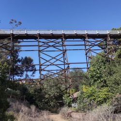
Review of North Fortuna. Fun hike, but way more challenging than anticipated (based on reviews I read on multiple websites prior to going). I will admit, we may not have taken the most direct route to the summit and our overall hike was 7.5 Miles in about 3.5 hours. *see my posted picture for exact route. There were multiple steep gravel hills, which were hard on the legs going up, but really slippery while attempting to do down (especially where you hike parallel to the noisy highway 52- if you take that route). Maybe a walking stick and actual hiking boots vs sneakers would've helped a bunch. Bring water!! The views are nice on a clear day, but just be prepared for a challenge -physically and mentally. read more
. Start at east fortuna staging area (parking lot) - Hiking Near Me - San Diego, California")

Page 1 of 3
More info about Fortuna Mountain
Ask the Community - Fortuna Mountain
Can anyone give the accurate address for fortuna mountain trail ? 2nd time I tried always take me to a side walk of housing area
Review Highlights - Fortuna Mountain
You might also consider


Fortuna Mountain - hiking - Updated July 2026
Best of San Diego
People found Fortuna Mountain by searching for…
Hiking Trails in San Diego, CA
Stairs Workout in San Diego, CA
Paved Walking Trails in San Diego, CA
Stair Climbing in San Diego, CA
Beautiful Views in San Diego, CA
Off Leash Dog Hiking Trails in San Diego, CA
Fishing Spots in San Diego, CA
Rock Climbing in San Diego, CA
Running Stairs in San Diego, CA
Trending Searches in San Diego, CA
Blueberry Picking near Fortuna Mountain
Cliff Jumping near Fortuna Mountain
Day Trips near Fortuna Mountain
Dog Friendly Beaches near Fortuna Mountain
Jet Ski Rental near Fortuna Mountain
Kayak Rental near Fortuna Mountain
Lakes & Ponds near Fortuna Mountain
Off Road Trails near Fortuna Mountain
Outdoor Activities near Fortuna Mountain
Peach Picking near Fortuna Mountain
Places To Swim near Fortuna Mountain
Places To Walk Around near Fortuna Mountain
Pokemon Go near Fortuna Mountain
Pool Day Pass near Fortuna Mountain
Public Shower near Fortuna Mountain
River Swimming near Fortuna Mountain
River Tubing near Fortuna Mountain
Rock Quarry near Fortuna Mountain
Scenic Night View near Fortuna Mountain
Scenic Overlook near Fortuna Mountain
Secluded Spots near Fortuna Mountain
Soccer Store near Fortuna Mountain
Sunrise View near Fortuna Mountain
Swimming Holes near Fortuna Mountain
Swimming Lakes near Fortuna Mountain
U Pick Farms near Fortuna Mountain
Browse Articles
Browse Nearby
BEST of San Diego, California Coffee near Fortuna Mountain
BEST of San Diego, California Restaurants near Fortuna Mountain
BEST of San Diego, California Things to Do near Fortuna Mountain
BEST of San Diego, California Breakfast near Fortuna Mountain
BEST of San Diego, California Walking Trails near Fortuna Mountain
BEST of San Diego, California Parks near Fortuna Mountain
BEST of San Diego, California Campgrounds near Fortuna Mountain
BEST of San Diego, California Glamping near Fortuna Mountain
Browse Brands
Related Searches in San Diego, CA
Affordable Kayak Rental Services in San Diego, California
Best Dog Hiking Trails Around San Diego, California
Best Fishing Locations and Guides in San Diego, California
Best Nature Trails for Hiking in San Diego, California
Best Places for Horseback Riding in San Diego, California
Best Sightseeing Experiences Available in San Diego, California
Check Out Off Road Trails in San Diego, California
Discover Dog Friendly Trails to Explore in San Diego, California
Discover Easy Hiking Trails Near San Diego, California
Discover Kid Friendly Hiking Trails in San Diego, California
Discover Popular Bike Trails in San Diego, California
Discover Scenic Mountain Bike Trails Near San Diego, California
Discover Walking Parks in San Diego, California Near You
Discover a Hiking Trail in San Diego, California
Discover the Best Night Hike Trails in San Diego, California
Dog-Friendly Hikes With Dogs in San Diego, California
Enjoy Camping Adventures Around San Diego, California
Enjoy Kayaking Adventures in San Diego, California
Enjoy Off Leash Dog Hikes in San Diego, California
Enjoy Scenic Places to Walk in San Diego, California
Enjoy Tent Camping Spots Around San Diego, California
Enjoy a Beautiful Waterfall Hike in San Diego, California
Enjoy the Best Walking Path in San Diego, California
Enjoy the Best Walking Trails in San Diego, California
Explore Beautiful Parks and Green Spaces in San Diego, California
Explore Easy Hikes Perfect for All in San Diego, California
Explore Fun Activities to Do in San Diego, California
Explore Picnic Parks Near San Diego, California
Explore Popular Campgrounds Near San Diego, California
Explore Top Dog Parks in San Diego, California Near You
Explore the Best Beach Spots in San Diego, California
Family Friendly Hiking With Kids in San Diego, California
Find Top Dog Friendly Parks to Visit in San Diego, California
Find the Best Parks for Picnics in San Diego, California
Hiking Trails With Waterfalls in San Diego, California
Off Leash Dog Hiking Trails in San Diego, California
Popular Outdoor Activities to Try in San Diego, California
Popular Picnic Spots to Visit in San Diego, California
Popular Waterfall Hiking Trails in San Diego, California
Safe River Swimming Areas in San Diego, California
Safe and Fun Parks for Kids in San Diego, California
Top Hiking Trails to Explore in San Diego, California
Top Playgrounds for Kids to Enjoy in San Diego, California
Top Running Trails to Explore in San Diego, California
Top Swimming Lakes to Enjoy in San Diego, California
Top Swimming Spots and Pools in San Diego, California
Top-Rated Camping Sites in San Diego, California
People who viewed Fortuna Mountain also viewed
Pyle's Peak
40 reviews
San Carlos
Old Mission Dam Trail
13 reviews
Maple Canyon Trail
20 reviews
Banker's Hill
Bayside Trail
16 reviews
Point Loma
Kwaay Paay Trail and Summit
76 reviews
Los Penasquitos Canyon Preserve
395 reviews
Mira Mesa, Torrey Hills
Sweetwater Trail
9 reviews
Kearny Mesa
Navajo Canyon Open Space
11 reviews
Del Cerro
Oakoasis County Preserve
19 reviews
Devil's Jumpoff
4 reviews