Oak Canyon Trail Photos


You might also consider
More like Oak Canyon Trail
Recommended Reviews - Oak Canyon Trail
Start your review...

Reviews With Photos

Besides the five peaks at Mission Trails Regional Park, there are numerous smaller routes you can hike with various levels of difficulty. The Oak Canyon Trail originates near the Old Mission Dam in the northeast section of the park. The lot adjacent to the trailhead closes at 7 pm. If you want to complete a trek beyond that time and not have your vehicle locked in overnight, then park in the lot at the corner of Bushy Hill Dr and walk west on the Father Junipero Serra Trail. You will pass the trailhead for Kwaay Paay Peak en route. The water level at the dam is currently low so the scenery is not as pretty compared to during the rainy season. The trail starts south of the dam and then begins a loop that heads north and west. Some areas are quite rocky as the path is along a canyon/creek bed. You will pass a giant oak tree which I failed to capture a photo of. :( A waterfall does appear in the Oak Canyon during winter and springtime which might be worth returning to view. As you reach the top of the loop, you will see the overpass of SR-52 that crosses above the canyon. From there is a short but steep eastward ascent that is part of the North Fortuna Perimeter Trail. The route continues in that direction and then descends along the Grassland Loop Trail. This portion is very wide and rather flat. It feels like you are walking in a prairie with the surrounding tall, dried wild grasses. The Grassland section makes up the eastern/southeastern areas of the circuit. By the time you return to the dam, the distance traveled was a tad under four miles which I completed in 90 minutes of actual walking time. Watch out for the wildlife as rabbits, squirrels, and even rattlesnakes may show up which happened to me once and forced a detour off the beaten path. I carry trekking poles not only to assist with the ascents and descents but also as a defense weapon in case some critter gets too close for comfort. Overall, the Oak Canyon Trail including the Grasslands Loop was easy with only moderate difficulty when you had to ascend one slope on the northern perimeter.

This was such a great easy mild hike, especially good for families. I came to this hike 4/2/23 after a couple weeks of rainy season so there was a good amount of the water on the hike. We parked on the side of the road next to the San Diego old mission dam parking lot because the parking lot was full by 8am. The path was straightforward and easy follow, though some parts of the trail were very wet from all the rain that had been happening a few days before. On the way, we saw the dam, crossed a couple bridges, scrambled over some rocks, and saw about two mini sized waterfalls. After the second mini waterfall, we headed back the way we came from and the whole hike took us about 1.5 hours or less. Great little hike if you want to take it easy but still want to enjoy the peacefulness of nature.


A family-friendly hike with some small waterfalls after a few days of rain.... This isn't a loop trail but more of a connection trail where you can choose just the level of exercise that you're looking for. Hiking this trail starts off at the Old Mission Dam, then it meanders along a creek. Feel free to go off-trail and hike right by the creek as it will eventually re-connnect with the oak trail. There are three options you can experience while on the oak trail. Option 1 is taking the grassland trail loop. Ideal for people that seek a flat trail and few rocks. Just know there is no shade on the grassland trail. Option 2 is staying on the oak canyon trail and hiking to the waterfalls.. Very fun indeed and even more so during March with all of the flowers blooming. You will be climbing through rocks which is fun for kids. Option 3 is going past the waterfalls and marching to Fortuna Mountain. Obviously, experienced family-hikers can try this. Definitely not for people without a bunch of water and stamina. Overall this a great family trail for all skill levels. Best experienced winter/early spring.


This is a nice 3.5 miles roundtrip hike in Mission trails park. The trail runs along the creek and there is some shade (at least in the canyon). Elevation gain is minimal, but the trail can be fairly uneven. Pick your time wisely - it's a popular trail and can get busy. If the water is flowing, you'll see a nice little waterfall at the end of the trail. There is little parking at the trailhead, but there is parking along the road.

This is a quite beautiful trail and short too. There are actually two sections where you'll see a 'waterfall' so make sure you pay attention. There are some areas where the terrain is uneven and you'll be walking over rocks and some bigger rocks, so be cautious if you have bad ankles. It can also get muddy in some sections so don't wear shoes that you don't want to get dirty.


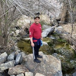
This trail is an out & back, approx 3.2 miles, starting at the Father Junipero Serra Ave to 52 Freeway. Easy, mostly flat, couple of inclines but not steep. It might get challenging for some; towards the end, as the trail gets rocky and may become slippery. The trail follows the San Diego river, so it depends on the amount of rain So.Cal receives. The trail head starts at The Old Mission Dam, near a small parking lot. The parking lot does not open until 8/9 am, so it if like to hike early you will have to park along the street. Walk towards the gate approx .5 miles and the trail entrance will be on your right. As you walk up you could hear water flow...it's so relaxing. You continue down the path you will see a meadow and the trail will split, stay to your left. There various trails you could take, but if you want to reward yourself with a waterfall at the end, stay on the path. Beware of poison oak along the river. Leaves of three, let it be... Great hike!! Beautiful scenery. Very rewarding.

Oak canyon trail to grassland loop I a nice hiking trail. I went on a Saturday early in the morning and it wasn't too busy until the sun came up. It a pretty popular trail that currently has running water. Lots of good picture spots and the sound of nature is pretty awesome. It's good for all ages and it's easy to moderate. Definitely go while there is still water and not to late in the morning or early afternoon. Stay hydrated and avoid the sun... there are some covered areas along this hike but a hat is recommended. Happy hiking!!!

Oak Canyon trail is one very scenic trail. Listed as one of the 10 best hikes in San Diego in some publications. After completing most of the trail, I now know why. Go to Mission Trails Regional Park to find this trail. You may find it difficult to find at times because this trail intersects with many other trails at this park. We started the Oak Canyon Trail near the Old Mission Dam. I would rate this trail mostly easy with some moderate parts along the route. The moderate areas would be where you have to do a little bit of rock scrambling along the stream/creek beds. I believe it is about 6 to 7 miles long. Saw folks of all ages walking along the trail. Great place to take your significant other, kids, and your dog on a leash. When in the San Diego area, come to Oak Canyon trail (if you want to exercise a bit). Have fun!

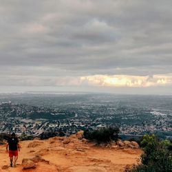
So the Oak Canyon trail is one if my favorite in Mission Trails park. It's far overlooked for more popular trails like the Fortuna summits or trails more towards the visitor center. You can start the Oak Canyon trail either at the dam or off the North Fortuna perimeter trail that links up to the Grassland area. The canyon stretches from the 52 freeway all the way into where the dam area is. There's lots of rocks for climbing and jumping around on. There really isn't anything serious to climb, the walls aren't really that tall. During some rain storms you'll get some small streams going through the canyon and some decent water as you make your way back towards the dam. The trail in itself is about 2 miles or so going one way, so it's not an all day event. Even though the trail is well traveled and you'll see alot of people, you still can get some decent alone time out here. The trail kinda goes which way when you walk through the low stream areas, but you can't get lost out here. As far as difficulty, the mission trails rates it moderate but I think it's pretty easy. There really isn't any type of incline but if you can't maintain your balance very well, you might want to skip out on this trail. As far as wild life goes, you'll see a decent amount of birds, snakes when it's hot and of course rabbits. I've yet to encounter any coyotes in this specific area, but they do travel around the park. If you like rocks, this is the trail for you.


Good hike, the trails get a little confusing and could be marked a little better, but a nice hike, not very challenging, but a nice walk through nature, one trail, that starts to climb is fairly narrow, be careful. I saw a snake, didn't look threatening, but I don't know much about snakes, other favorite being the black mamba #Kobe!!! Another hiker alerted us that she had seen a few snakes on the way coming up, we were headed down, but didn't run into them. One trail runs along a creek, very peaceful. A wedding was taking place at the oak trail center. There's also a nice lap you could do around the reservoir, check out the personalized rock collection or leave one of your own! read more


If you're looking to do an easy nature trail walk, I recommend this one! Right from the start you see a lake scenery with lots of trees and plants on the water. There were trees with yellow leaves because it's fall. Didn't see much wild life. There were bridges and streams. No steep hills. Beautiful views and atmosphere. read more


We parked at a large lot next to the Visitor Center (plenty of spots ~ 830AM). We walked approximately 1.5mi to the Old Mission Dam (lots of water!) then proceeded according to the Google Maps for "Oak Canyon Trail" since the map at the Visitor Center didn't show where the waterfall was. We have done portions of this hike coming from other entry points when it was DRY, and everything was rocks and dirt. With the recent rains, areas that were previously rocks/dirt were now covered with running water. It actually took awhile to get from the "Giant Oak Tree" landmark to where the waterfall was supposed to be, because two-way traffic was needing to stop and wait for each other, since in parts of the trail, only a sliver of muddy ground could be traversed. If you are wanting to do this hike now, you will not be able to take strollers on this path & you should be somewhat surefooted because the rocks can be slippery. Stupidly, I can't figure out if I actually saw a waterfall. I saw a lot of segments in which the flowing water would "fall" a foot or so (one photo attached). Overall, it was a beautiful hike and wonderful to see a familiar hiking trail completed transformed by the rains. That being said, it was supposed to be an out-and-back hike but we were not interested in clambering through mud/rocks/water again so we actually used the North Fortuna to Grassland loop trail to get back to the Visitor center. This turned a 3mi hike into an 8mi one. Our bodies were very tired read more


Besides the five peaks at Mission Trails Regional Park, there are numerous smaller routes you can hike with various levels of difficulty. The Oak Canyon Trail originates near the Old Mission Dam in the northeast section of the park. The lot adjacent to the trailhead closes at 7 pm. If you want to complete a trek beyond that time and not have your vehicle locked in overnight, then park in the lot at the corner of Bushy Hill Dr and walk west on the Father Junipero Serra Trail. You will pass the trailhead for Kwaay Paay Peak en route. The water level at the dam is currently low so the scenery is not as pretty compared to during the rainy season. The trail starts south of the dam and then begins a loop that heads north and west. Some areas are quite rocky as the path is along a canyon/creek bed. You will pass a giant oak tree which I failed to capture a photo of. :( A waterfall does appear in the Oak Canyon during winter and springtime which might be worth returning to view. As you reach the top of the loop, you will see the overpass of SR-52 that crosses above the canyon. From there is a short but steep eastward ascent that is part of the North Fortuna Perimeter Trail. The route continues in that direction and then descends along the Grassland Loop Trail. This portion is very wide and rather flat. It feels like you are walking in a prairie with the surrounding tall, dried wild grasses. The Grassland section makes up the eastern/southeastern areas of the circuit. By the time you return to the dam, the distance traveled was a tad under four miles which I completed in 90 minutes of actual walking time. Watch out for the wildlife as rabbits, squirrels, and even rattlesnakes may show up which happened to me once and forced a detour off the beaten path. I carry trekking poles not only to assist with the ascents and descents but also as a defense weapon in case some critter gets too close for comfort. Overall, the Oak Canyon Trail including the Grasslands Loop was easy with only moderate difficulty when you had to ascend one slope on the northern perimeter. read more


This was such a great easy mild hike, especially good for families. I came to this hike 4/2/23 after a couple weeks of rainy season so there was a good amount of the water on the hike. We parked on the side of the road next to the San Diego old mission dam parking lot because the parking lot was full by 8am. The path was straightforward and easy follow, though some parts of the trail were very wet from all the rain that had been happening a few days before. On the way, we saw the dam, crossed a couple bridges, scrambled over some rocks, and saw about two mini sized waterfalls. After the second mini waterfall, we headed back the way we came from and the whole hike took us about 1.5 hours or less. Great little hike if you want to take it easy but still want to enjoy the peacefulness of nature. read more


4 years ago
Nice hike, fairly straight path, wear good hiking shoes to walk over the rocks Beautiful scenery all around!! read more

A family-friendly hike with some small waterfalls after a few days of rain.... This isn't a loop trail but more of a connection trail where you can choose just the level of exercise that you're looking for. Hiking this trail starts off at the Old Mission Dam, then it meanders along a creek. Feel free to go off-trail and hike right by the creek as it will eventually re-connnect with the oak trail. There are three options you can experience while on the oak trail. Option 1 is taking the grassland trail loop. Ideal for people that seek a flat trail and few rocks. Just know there is no shade on the grassland trail. Option 2 is staying on the oak canyon trail and hiking to the waterfalls.. Very fun indeed and even more so during March with all of the flowers blooming. You will be climbing through rocks which is fun for kids. Option 3 is going past the waterfalls and marching to Fortuna Mountain. Obviously, experienced family-hikers can try this. Definitely not for people without a bunch of water and stamina. Overall this a great family trail for all skill levels. Best experienced winter/early spring. read more


6 years ago
Great hike! Not much shade, so go when it's not super hot. There's great oak trees along the way and a cool dam. read more

3 years ago
This is a nice 3.5 miles roundtrip hike in Mission trails park. The trail runs along the creek and there is some shade (at least in the canyon). Elevation gain is minimal, but the trail can be fairly uneven. Pick your time wisely - it's a popular trail and can get busy. If the water is flowing, you'll see a nice little waterfall at the end of the trail. There is little parking at the trailhead, but there is parking along the road. read more


7 years ago
This is a quite beautiful trail and short too. There are actually two sections where you'll see a 'waterfall' so make sure you pay attention. There are some areas where the terrain is uneven and you'll be walking over rocks and some bigger rocks, so be cautious if you have bad ankles. It can also get muddy in some sections so don't wear shoes that you don't want to get dirty. read more


3 years ago
7 years ago
I really enjoyed this trail, there's different paths you can take. Not difficult at all. We went after rain fall, so it was a bit muddy but there was definitely lots of water in the stream! Really peaceful! read more


5 years ago
This trail is an out & back, approx 3.2 miles, starting at the Father Junipero Serra Ave to 52 Freeway. Easy, mostly flat, couple of inclines but not steep. It might get challenging for some; towards the end, as the trail gets rocky and may become slippery. The trail follows the San Diego river, so it depends on the amount of rain So.Cal receives. The trail head starts at The Old Mission Dam, near a small parking lot. The parking lot does not open until 8/9 am, so it if like to hike early you will have to park along the street. Walk towards the gate approx .5 miles and the trail entrance will be on your right. As you walk up you could hear water flow...it's so relaxing. You continue down the path you will see a meadow and the trail will split, stay to your left. There various trails you could take, but if you want to reward yourself with a waterfall at the end, stay on the path. Beware of poison oak along the river. Leaves of three, let it be... Great hike!! Beautiful scenery. Very rewarding. read more

Oak canyon trail to grassland loop I a nice hiking trail. I went on a Saturday early in the morning and it wasn't too busy until the sun came up. It a pretty popular trail that currently has running water. Lots of good picture spots and the sound of nature is pretty awesome. It's good for all ages and it's easy to moderate. Definitely go while there is still water and not to late in the morning or early afternoon. Stay hydrated and avoid the sun... there are some covered areas along this hike but a hat is recommended. Happy hiking!!! read more


9 years ago
Oak Canyon trail is one very scenic trail. Listed as one of the 10 best hikes in San Diego in some publications. After completing most of the trail, I now know why. Go to Mission Trails Regional Park to find this trail. You may find it difficult to find at times because this trail intersects with many other trails at this park. We started the Oak Canyon Trail near the Old Mission Dam. I would rate this trail mostly easy with some moderate parts along the route. The moderate areas would be where you have to do a little bit of rock scrambling along the stream/creek beds. I believe it is about 6 to 7 miles long. Saw folks of all ages walking along the trail. Great place to take your significant other, kids, and your dog on a leash. When in the San Diego area, come to Oak Canyon trail (if you want to exercise a bit). Have fun! read more


So the Oak Canyon trail is one if my favorite in Mission Trails park. It's far overlooked for more popular trails like the Fortuna summits or trails more towards the visitor center. You can start the Oak Canyon trail either at the dam or off the North Fortuna perimeter trail that links up to the Grassland area. The canyon stretches from the 52 freeway all the way into where the dam area is. There's lots of rocks for climbing and jumping around on. There really isn't anything serious to climb, the walls aren't really that tall. During some rain storms you'll get some small streams going through the canyon and some decent water as you make your way back towards the dam. The trail in itself is about 2 miles or so going one way, so it's not an all day event. Even though the trail is well traveled and you'll see alot of people, you still can get some decent alone time out here. The trail kinda goes which way when you walk through the low stream areas, but you can't get lost out here. As far as difficulty, the mission trails rates it moderate but I think it's pretty easy. There really isn't any type of incline but if you can't maintain your balance very well, you might want to skip out on this trail. As far as wild life goes, you'll see a decent amount of birds, snakes when it's hot and of course rabbits. I've yet to encounter any coyotes in this specific area, but they do travel around the park. If you like rocks, this is the trail for you. read more


9 years ago
3 years ago
7 years ago
It's really beautiful out there right now after several weeks of rain, so worth going to see the streams and greenery. The trail is pretty crowded though and you have to keep stepping to the side to pass people. There were big groups of 10-15 people, so not ideal for peace and quiet. read more


7 years ago
My friend and I decided to go for a walk today. We decided on Oak Canyon in Mission Trails. I liked the Old Dam in the beginning and than we we headed down the trail into the grasslands loop. Talk about getting away from the fast pace in the city. Wow! The landscape feels so vast than we ventured off into the Oak Canyon South and north sections, it is not crowded by any means and the people on the trail are pretty friendly. Also, this is a very good hike for someone who is just getting started. read more

This is a fun hike that is good for all age groups. There is a bit of scrambling in a few spots, but you can go around these obstacles in most areas. If you get here early in the morning you stand a good chance of seeing mule deer and coyotes which are found throughout MTRP. I've seen bobcat tracks but never any mountain lions; although, they are reported to be in the area. Mountain bikes aren't allowed on this trail but dogs are as long as they are on a leash. Have fun! read more


7 years ago
10 years ago
8 years ago
Gorgeous hiking trails located inside mission trails park. peaceful and serene, perfect place to renew yourself. Trails are easy and is perfect for all levels and ages including kids . Not stroller friendly but there are asphalt road surrounding the trails that you could use and the view is equally magnificent. Highly recommended. Bonus: Free parking! read more


More info about Oak Canyon Trail
Santee, CA 92071
Directions
Hours
Outdoor Amenities
Ask the Community - Oak Canyon Trail
Review Highlights - Oak Canyon Trail
You might also consider


Oak Canyon Trail - hiking - Updated July 2026
Best of Santee
People found Oak Canyon Trail by searching for…
Places to Take Pictures in Santee, California
Hiking Trails in Santee, California
Beautiful Views in Santee, California
Scenic View in Santee, California
Waterfall Hike in Santee, California
Natural Hot Springs in Santee, California
Photo Spots in Santee, California
Walking Trails in Santee, California
Easy Hikes in Santee, California
Wildflowers in Santee, California
Secret Spots in Santee, California
Fun Things to Do in Santee, California
Free Things to Do in Santee, California
Off Road Trails in Santee, California
Off Leash Dog Hiking Trails in Santee, California
Dog Friendly Hiking Trails in Santee, California
Full Moon Hike in Santee, California
Running Trails in Santee, California
Running Routes in Santee, California
Shaded Hike in Santee, California
Trending Searches in Santee, CA
Browse Articles
Browse Nearby
BEST of Santee, California Coffee near Oak Canyon Trail
BEST of Santee, California Restaurants near Oak Canyon Trail
BEST of Santee, California Things to Do near Oak Canyon Trail
BEST of Santee, California Breakfast near Oak Canyon Trail
BEST of Santee, California Parks near Oak Canyon Trail
BEST of Santee, California Horseback Riding near Oak Canyon Trail
BEST of Santee, California Campgrounds near Oak Canyon Trail
Browse Brands
Related Searches in Santee, CA
Affordable Kayak Rental Services in Santee, California
Best Fishing Locations and Guides in Santee, California
Best Places for Horseback Riding in Santee, California
Best Waterfalls and Swimming Holes in Santee, California
Check Out Off Road Trails in Santee, California
Discover Dog Friendly Trails to Explore in Santee, California
Discover Scenic Hiking Trails in Santee, California
Discover Scenic Mountain Bike Trails Near Santee, California
Discover Walking Parks in Santee, California Near You
Discover a Hiking Trail in Santee, California
Discover the Best Night Hike Trails in Santee, California
Dog-Friendly Hikes With Dogs in Santee, California
Enjoy Camping Adventures Around Santee, California
Enjoy Exciting Mountain Biking Adventures in Santee, California
Enjoy Kayaking Adventures in Santee, California
Enjoy Tent Camping Spots Around Santee, California
Enjoy a Beautiful Waterfall Hike in Santee, California
Enjoy a Peaceful Nature Walk in Santee, California
Enjoy the Best Picnic Spots and Ideas in Santee, California
Enjoy the Best Walking Path in Santee, California
Enjoy the Best Walking Trails in Santee, California
Exciting Cliff Jumping Spots in Santee, California
Explore Beautiful Parks and Green Spaces in Santee, California
Explore Easy Hikes Perfect for All in Santee, California
Explore Fun Activities to Do in Santee, California
Explore Popular Campgrounds Near Santee, California
Explore the Best Beach Spots in Santee, California
Explore the Best Trail Options in Santee, California
Family Friendly Hiking With Kids in Santee, California
Find Beautiful Views in Santee, California
Find Popular Ziplining Spots Around Santee, California
Find the Best Parks for Picnics in Santee, California
Find the Best Scenic View Locations in Santee, California
Great Places to Walk in Santee, California
Hike the Popular Waterfall Trail in Santee, California
Hiking Trails With Waterfalls in Santee, California
Off Leash Dog Hiking Trails in Santee, California
Plan a Scenic Drive Route Near Santee, California
Popular Outdoor Activities to Try in Santee, California
Popular Picnic Spots to Visit in Santee, California
Safe River Swimming Areas in Santee, California
Safe and Fun Parks for Kids in Santee, California
Top Climbing Spots and Gyms in Santee, California
Top Paddleboarding Activities in Santee, California
Top Places for Snorkeling in Santee, California
Top Running Trails to Explore in Santee, California
Top Swimming Lakes to Enjoy in Santee, California
Top Swimming Spots and Pools in Santee, California
People who viewed Oak Canyon Trail also viewed
Navajo Canyon Open Space
11 reviews
Del Cerro
Stonewall Peak Trail
100 reviews
Old Mission Dam Trail
13 reviews
Cuyamaca Peak
32 reviews
Secret Canyon Trail
6 reviews
Oakoasis County Preserve
19 reviews
Kwaay Paay Trail and Summit
76 reviews
Hollenbeck Canyon Wildlife Area
20 reviews
Lake Murray
333 reviews
Pyle's Peak
40 reviews
San Carlos