Cancel

Open app

Search

Cottonwood Creek

4.7 (7 reviews)

Cottonwood Creek Photos
You might also consider

Recommended Reviews - Cottonwood Creek

Your trust is our priority, so businesses can't pay to alter or remove their reviews. Learn more about reviews.
Yelp app icon
Browse more easily on the app
Review Feed Illustration
Photo of Grace P.
66
92
136

4 years ago

Helpful 0
Thanks 0
Love this 0
Oh no 0

7 years ago

Helpful 17
Thanks 0
Love this 14
Oh no 2

11 years ago

Helpful 6
Thanks 0
Love this 0
Oh no 0
Photo of Jeff W.
25
101
108

11 years ago

Helpful 1
Thanks 0
Love this 1
Oh no 0
Photo of Ace A.
35
29
2

18 years ago

Helpful 9
Thanks 0
Love this 2
Oh no 0
Photo of Soul O.
7
10
61

9 years ago

Helpful 1
Thanks 0
Love this 1
Oh no 0
Photo of M I.
0
1
0

15 years ago

Helpful 0
Thanks 0
Love this 0
Oh no 0

Ask the Community - Cottonwood Creek

You might also consider

Verify this business for free

People searched for Hiking 200 times last month within 15 miles of this business.

Verify this business

Pacific Crest Trail At Penny Pines - Beauty that you will see on the Indian Creek trail loop in Mt Laguna

Pacific Crest Trail At Penny Pines

4.9(22 reviews)
5.9 mi

INDIAN CREEK LOOP REVIEW (8.8 miles)…read more Let's begin with 100% of hikes in Mt. Laguna or that includes the PCT will be an ethereal experience. Many say you can create, shape and mold reality. Others will say manifest and it will come. And then there are some that are just bah humbug. I always revel in God's imagination and creativity when he created these mountains. And then gave the gift of ingenuity to humans to work to create pathways and trails for us to enjoy and simply relish in gratitude and awe the entire hike. I'm a real hiker. Real backpacker. Real camper. And real glamping. I hike 2x a week for more than a decade. This is only to give you perspective of this review. This is my first time doing the full loop that included Pacific Crest Trail,Pine Mountain Road,Indian Creek Trail,and Noble Canyon Trail AKA "Indian Creek Loop." And today was wonky. Some parts were hard, some parts were easy, same parts were as if my body never has done hiking before. It was a doozy. I would likely do this hike again within the next couple of weeks. Because in my imagination, I'm an amazing hiker and that did not show today when I was struggling. I love taking photos and there was about an hour where I was trying to manage my breathing and focus and trek poles that I took no photos. Yep, I let the mountain win, smh. On this day, spectacular hike with alternating elevation, endless greenery, and blooming plants. Walking the legendary PCT, passing the "Canada" sign, and glimpsing Anza Borrego's desert floor was unforgettable. From rocky paths to meadows and mountain views, every turn offered something new. No one on the trail until the final half mile where bikers were on trail. I started at Piney Pines. Next time I'll go counterclockwise. GOOD TO KNOW *Att network excellent reception the entire trail *I felt safe as a solo hiker but I still get the quesies. I carry a few safety thins. Shhh. Don't tell *Hike time: 3 hrs, 3 minutes *90% exposed hike. *At the 4 mile marker, shade, benches and toilets. The toilets are unsanitary. I don't want to vomit and make it worse so I do my thing in nature. *When you start there's a point where you just have to finish *You can break this up to build up your mileage over time THIS HIKE IS NOT FOR: *Newbies, there's elevation involved *Whiners, complainers, or scaredy cats *Those who I have only done Cowles Mountain and think this is the next level "Life can be limited and you miss out. But create your own unlimitedness and you must do this hike."

This review is for the Garnet Peak via Pacific Crest Trail which was a 4 mile round trip that took…read moreabout 2 hours to complete. The trail for the most part was easy to follow and completely exposed to the sun. A good portion of the trail was rocky which could make your foot a bit uncomfortable. There were also a few instances where you could go off trail for a bit to check out the desert views! Short video of the hike for those interested: https://www.youtube.com/watch?v=htU3_t3cDMI

Photos
Pacific Crest Trail At Penny Pines - Beauty that you will see on the Indian Creek trail loop in Mt Laguna Garnet Peak

Beauty that you will see on the Indian Creek trail loop in Mt Laguna Garnet Peak

Pacific Crest Trail At Penny Pines

See all

Enjoy the Mountain San Diego

Enjoy the Mountain San Diego

4.3(10 reviews)
1.8 mi

We had a great time with Emil on a 1 hr ride through rain and snow flurries. The ride was safe,…read morewell paced and super fun. I would recommend wearing some waterproof pants/jacket if you are going during such weather. This is my new favorite activity! Can't wait to do it again.

I booked this adventure for 2 reasons: (1) to FINALLY get out of the house during this pandemic…read moreespecially since all we have been doing is working and we have been working more than ever since our job is considered 'essential', and (2) celebrate my boyfriends 30th birthday. This was my first time on a quad/ATV and my boyfriend has been riding dirt bikes since he was like 6yrs old. I love being outdoors & going on new adventures, and he loves riding ... so the mixture of those things i came upon this place. For birthdays I love and prefer creating memories instead of giving materialistic gifts. Example: For his 28th birthday I booked us a little personal speed boat in San Diego. Upon arrival check-in was easy, quick, and they gave us hand sanitizer so we felt assured. They had helmets and other PPE lined up and available for us to use, however we had brought our own (riding gloves, riding jerseys, riding DOT certified helmets, and googles) which they allow. Our guide Jorge was funny and very easy going. The ride overall was really fun!! During our ride our guide also took pictures of us and he took some awesome ones with amazing backdrops! The only complaint I have was that I only booked us the 1 hour ride. Next time we are doing the 2 hour ride for sure! And maybe the Big Bear location as well.

Photos
Enjoy the Mountain San Diego
Enjoy the Mountain San Diego - Through the rocks

Through the rocks

Enjoy the Mountain San Diego - Let's take a break

See all

Let's take a break

Corte Madera Mountain - Free!

Corte Madera Mountain

4.4(8 reviews)
7.3 mi

This mountain is one of the 6 peak San Diego challenge. It's about 7 miles and 1,500 ft elevation…read moregain. It is very doable for folks of all levels. Beginners can take it slow. Beautiful view from the top! I'm all about the summit pictures. Please come and create your own adventure.

I did this hike for the first time on 5/27/18 and REALLY enjoyed the hike. I did this as part of…read morethe Tardigrade Tough 8 Challenge which comprises 8 of the hardest hikes in the San Diego area. If you are interested follow @tt8challenge and/or @resilientsquad on Instagram. Here are the main details of the hike: Name: Corte Madera in Alpine, CA (east of San Diego) Distance: 7 miles Elevation Gain: 1,500 ft Elevation at Peak: 4,657 ft. Duration: 3-4 hrs Difficulty: Moderate *I used the directions from the All Trails App, not the directions here...which the directions are essentially the same up until the last part...basically the 8 East to Exit 51 Buckman Springs Rd, turn right and in 3.3 miles you will turn right on a small side road named Morena Stokes Valley Rd which is a narrow somewhat paved/dirt bumpy road and in 4.8 miles you will see a green metal gate with a red cross on it...parking for about 5 or 6 cars on the left of the road and the hike starts at the metal gate We arrived at 6:15 am and we were the first to park in the parking area. We saw no one on our way to the peak and saw less than 10 people on our return from the peak. I really enjoy hikes where there are little to no people and there are no sounds of cars or noises except for nature. For the first .7 miles of the hike you are on an access road lined with oaks provided cover until you reach a metal garbage can with a wooden sign that says Espinosa Trail on the left, this is the way you need to go and you will now be on a narrow single file trail. At 1.5 miles you will come to an official metal sign which indicates Los Pinos Peak to the left and Espinosa Trail straight, just below this sign is a handmade looking wooden sign with "Corte Madera Mt" and an arrow pointing to the right...follow this sign. At 1.9 miles you will see an official sign indicating you are entering a nesting area for birds of prey with a wooden handmade sign pointing the way to "CM" and an arrow...follow this sign. At about 2.6 miles you will see the destination off to your left and you will see why it is called by some the San Diego Half Dome. The final .9 miles to the peak will curve around to the left and you will make a half circle to the peak when you reach about 3.4 to 3.5 total miles. There was no sign at the peak but there was a green metal container with the name and elevation on it. There is a variation to the scenery on this trail with some shaded and some exposed areas and some cool rocks and there was a nice variety of colors (green, yellow, and violet), but most importantly were the great views at the top. On the day we hiked it was misting in the beginning and lots of fog/low clouds, but by the time we got within a mile from the top we had hiked high enough to be above the clouds and it was clear and beautiful up there. It is definitely worth the drive to do this hike and I highly recommend it.

Photos
Corte Madera Mountain - "Jason Travolta"

"Jason Travolta"

Corte Madera Mountain - Obligatory group picture at the top

Obligatory group picture at the top

Corte Madera Mountain - Creating epic moments

See all

Creating epic moments

Merigan Trail

Merigan Trail

4.7(3 reviews)
7.0 mi

An outstanding "under the radar" waterfall hike is right here in Descanso. The Merigan Trail (aka…read morethe Merigan Fire Road) is closer than you think at just five minutes off the 8 freeway. Once at the trailhead, you will start your hike through an open meadow, passing some shady oak groves then finishing with waterfalls crashing on large boulders. I was introduced to this gem when I was at sixth grade camp, at Camp Oliver. I knew the Merigan Trail was great even then, but now I can truly appreciate how this area was left untouched after all these years. If it is your first time here, you will be back. FYI..there was still snow on the ground when we went in early January. There is no official address, but the place is right off Viejas Boulevard at Mitzpah Lane. Since it is part of the Cuyamaca State Park, they have their own signs, dirt parking lot, port-a-potties and the "honor system" check in station. I guess they ask for an 8 dollar fee to park. From the parking lot, walk to the trail head going left that passes right in front of a ranger's cabin. You can't miss the trail, since it is wide enough to drive a truck through. Stay on the trail and you will pass through a meadow, then an oak grove, this will then turn into a few mild inclines on the trail that will eventually lead you to a fork in the trail. At the fork, you will see a sign with the option to go to the "Dead Horse Trail" or stay on the "Merigan Fire Road." I always take the Dead Horse Trail, and go left at the fork in the trail to get to the waterfalls. The hike to the waterfall takes about 30-40 minutes for the average hiker with a few stops to admire the scenery. On a scale of 1-10 for difficulty, I would rate it at a 3. There are some inclines, but nothing too bad. Remember, my entire 6th grade class made the hike. Although I love Mission Trails and Cowles Mountain as much as the next hiker...those spots are flooded with way too many bodies. Just when you think you hear a coyote or deer up ahead, it always ends up being another hiker. Kind of a buzz kill. The Merigan Trail has always been the opposite of that experience for me.
We did this hike based on the review above. There's something about the adventure of trying to…read morefind a waterfall based on one yelp review that sounded fun. It's pretty much just as the above review describes. Drive east on I-8 two exits past the Viejas outlets to Japatul rd and make a left. Make a left at hwy 79 and then an immediate left on Viejas Blvd. Look for Mitzpah rd and park in the dirt lot. Parking is $8. The hike to the waterfall is about 30 minutes. Take the fireroad and make a left at the fork down towards Dead Horse Trail. You will start to hear water. The falls aren't big and majestic, but it's quiet and uncrowded. We had 4 kids with us ranging from age 6 - 9 and they all had a good time.

Photos
Merigan Trail - Boulder moss thing.

Boulder moss thing.

Merigan Trail - 3 Year old and Daddy wading in the swimming hole

3 Year old and Daddy wading in the swimming hole

Merigan Trail - Snow was still in the shady parts of the trail.

See all

Snow was still in the shady parts of the trail.

Burnt Rancheria Campground - Tent caterpillar

Burnt Rancheria Campground

4.2(81 reviews)
5.3 mi

A surprise in our own backyard!!! A recommendation from a dear friend and an opportunity came to…read moretry the Burnt Rancheria Campground in the Cleveland National Park on Mt Laguna. Weather was perfect and the campground was ideal!!! Clean and well maintained helped to make our time this weekend worthwhile to truly appreciate and experience the Creations around us provided for our enjoyment but our Heavenly Father. Use GPS directions or you may pass the entrance. The entrance is right after the Pine Valley Cafe. Cellular reception is good in the mountains. I couldn't sleep the first night from all of the excitement so I sat alone in the middle of the field to gaze at the beautiful expanse of the heavens. Unbeknownst to me, that night a geomagnetic storm was creating amazing aurora borealis around the earth. Although my eye could not detect any hues or colors in the sky, my camera did and took some amazing photos!!! The next night I tried to take the same pictures and there were no hues, so I deduced that the night before must have been the Northern lights that the camera detected and recorded. At 6000' elevation I guess you can see incredible views of the sky!!! If you are 62 years old or older, apply for the "America The Beautiful" Senior Pass to receive a 50% discount on the Camping Fees. The Campground Hosts were very friendly if you show some respect and love to them. Shouldn't we all?

The campground was clean and well maintained. Bathroom was clean. Camp hosts were nice. Will return.read more

Photos
Burnt Rancheria Campground - Campsite

Campsite

Burnt Rancheria Campground - Tent and fire pit

Tent and fire pit

Burnt Rancheria Campground - Jay

See all

Jay

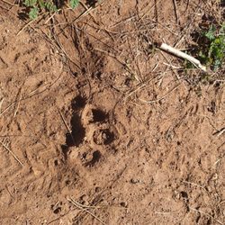
Monument Peak Hike - Mountain Lion tracks in hardened mud

Monument Peak Hike

4.7(3 reviews)
5.3 mi

A great (Loop) hike that is best experienced during fall…read more.. There are many ways to hike this trail, but mine is a 5 mile loop hike. Follow my suggestions and get a great family-friendly hike with great views, fresh air, and you'll get up close to microwave towers, a USAF Doppler radar ball, and cellular towers. Soo cool. Okay, you've put this hike on your list based on the pictures but there are a few thing you need to know. I started at the Desert View picnic area. This is a great parking area but you MUST have an adventure pass to park here. You'll have to buy a day, or annual park pass at any sports/adventure store. OR, I found a free parking alternative. Okay here we go. I'll talk about the free parking..If you're at the picnic area just hop on the PCT and head north.. The access to the free parking area it's the next North turnoff past the Desert View picnic area. Drive up the road to the lot and park in the dirt lot.. Check out the view!! For your reference look up the road and you'll see a big black gate.. this is where your loop hike will END... Don't worry, you will not be trespassing on this hike. That gate only blocks cars, not hikers. My loop starts at the Pacific Crest Trail, so if you parked at the free area walk down the road and look for the trailhead on the RIGHT side of the road.. TIP - Because this area doesn't have reliable cell service you will need to use GPS via Google Maps (or a hiking app) to find the actual "unmarked Monument trail". TIP if you can't use google maps, you'll have to look for the PCT marker that's at the base of a small hill.. just look for a tight opening through manzinita trees on the right just before that sign. The monument trail is tight, but you can do it. Hike to the top and hike around the various government installations..take pictures..have fun. To complete the loop, continue to walk down the service road past more towers and dome heading south.. it will take you all the way back to the viewpoint parking lot.. TIPS - Put the location of the Desert View picnic area in your google maps app for reference BEFORE you enter this area (no internet coverage up here). Remember if you park at the picnic area you need an adventure pass. No pass required if you park at the viewpoint lot. This loop didn't have a single no trespassing sign. So do walk the service road on the loop back.

The views at the top are spectacular. Tall Pines to the west, dry desert to the east. This peak…read morelies on what is known as a ecotone. A boundary between two distinctly different habitats. I used the directions provided here and they got me to a parking area off the shoulder on Sunrise Highway, about mile marker 25. The trailhead has between a barbed wire fence and the trail unmarked. You walk in a northerly direction for about half mile or so through a trail that looks vague in places do to lack of use, apparently. I got this info from a great hiking book called Afoot and Afield San Diego County by Jerry Schad. You'll walk until you get to another trail that intersects, and it's not marked. Follow it right on you'll be on the Big Laguna trail. Walk about 100 yards until you get to another trail intersection. It's the Pacific Crest trail and you'll follow it left. At the summit is a few radio and microwave antennas. Of interest was a laser target, standing about 6ft tall. I snapped a photo and uploaded it. When at the summit you'll appreciate the beautiful contrast of habitat as you pan around 360 degrees. It was especially windy this day, but very clear providing great views. Mount Stephenson and the large round white antennae towers can also be visited very near by. The views of the desert are amazing. This is an easy hike of about 4 miles out and back. Elevation gain 500 feet

Photos
Monument Peak Hike - You can see forever

You can see forever

Monument Peak Hike - Side hike to Stephenson Peak. Observe these signs. Government is not kidding

Side hike to Stephenson Peak. Observe these signs. Government is not kidding

Monument Peak Hike

See all

Harvey Moore Trail

Harvey Moore Trail

4.7(3 reviews)
6.3 mi

Backpacked to Granite Springs on parts of Harvey Moore loop. Nice trail with wildlife sightings and…read moregood primitive group camping.

Here is a real nature experience…read more Coming from San Diego, most of my hike outings have been relatively close to residential and other 'hikers' are plentiful. It's nice and all, but at times feels a bit fake. But Descanso, our neighbor to the not so distant east, finally quenched my Real Nature Thirst. It's definitely a different environment: rolling open fields, erie sleep hollow trees (even one fun to climb and get all sooty! [from its burnt state], ridges with flowing water below, creeks, forest-y parts...it really has it all! oh, including ticks that carry lyme disease, too - FYI. Some fellow hikers gave us the heads up to continuously check your socks and skin. There are some good climbs but mainly it's a distance factor that gives you your work out (roughly 14 miles). For the most part we were left to ourselves and nature, only occasionally running into horseback riders, and a a few hikers - could have been partly due to being Easter Sunday, but something tells me it allows for less foot traffic in general compared to other hiking areas. The funniest aspect of the visit was getting overly excited at spotting wild turkeys. That's how wilderness-starved I have become! This is definitely a great area to explore as a 1/2 day trip. If possible, acquire a map of the grounds before heading out. The trail markers can get confusing and it's easy to question if you are heading the right direction. Even GPS won't save you out here because reception can be lacking. We were lucky to run into 2 rangers on horses to verify getting back to our starting point. Added bonus to coming here: head to the store off the main road for some Dudley's Julian apple pie...ab-so-lut-ely delicious and satisfying end to all the calorie burning you just did! mmm.... Dudleys.

Photos
Harvey Moore Trail
Harvey Moore Trail
Harvey Moore Trail

See all

Cottonwood Creek - hiking - Updated May 2026

Loading...
Loading...
Loading...