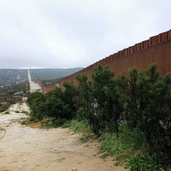
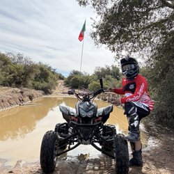
Corte Madera Mountain Photos


You might also consider
More like Corte Madera Mountain
Recommended Reviews - Corte Madera Mountain
Start your review...

Reviews With Photos - Corte Madera Mountain


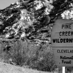
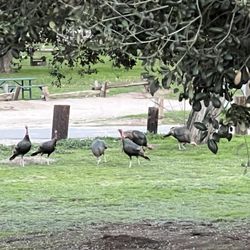
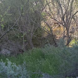
This one surprised us... quite the butt kicker for a regular hiker like myself. It was like a mini El Capitan Preserve trail, with about half the elevation gain (206 floors according to Fitbit... El Capitan had 430 floors) with ups and down starting halfway through. Some facts about the trail: Difficulty: moderately hard Distance (out and back): 7.32 miles Elevation gain: 1457 ft Landscape: Varies. Begins as a forest, then becomes brush desert, then mountain high brush desert. Traffic: None. We were the only ones on the trail today. Scenery: Really Really good for San Diego county. At first it isn't so much, but once you reach the crossroads where the trails split, it's great all the way to the top. Quaintness: Epic. Not a soul nor sound of human civilization... Aside from the occasional airplane flying overhead.... :/ Flora and Fauna: Great! Lots of lizards and birds, especially birds of prey. How to get there from San Diego: - Head east on I-8 - Get off on exit 51 Buckman Springs Rd take a right - 2.7 miles later take a right on Corral Canyon rd (aka Morena Stokes Rd) - 4.7 miles later there's a left hairpin turn and a gate with a heart on it. Keep on turn to park. Trail is behind gate. :) Note: all cars can get to trail... Part is dirt road. Just go slow. What you NEED to bring: - trail runners or hiking boots/shoes - Lots of water and some snacks - PANTS. This trail is narrow surrounded by high brush most of the way, some poison oak in shady areas - If going in spring or summer, BUG SPRAY!!! Bugs, bugs EVERYWHERE (on some parts of trail, especially the beginning.) What you COULD bring: - trekking poles for those who need knee support - Binoculars... Seriously... This is a GREAT hike for birdwatching raptors. I really wish I had brought mine. - light jacket to avoid brush. - nice camera for landscapes and selfies :P I liked this hike a lot, and consider it one of the better ones in San Diego. If it wasn't so out of the way I would come here often. I will recommend people with a good fitness level to check out this hike. 4 stars for a good moderately long hike with great scenery for the area and varied landscape!

I did this hike for the first time on 5/27/18 and REALLY enjoyed the hike. I did this as part of the Tardigrade Tough 8 Challenge which comprises 8 of the hardest hikes in the San Diego area. If you are interested follow @tt8challenge and/or @resilientsquad on Instagram. Here are the main details of the hike: Name: Corte Madera in Alpine, CA (east of San Diego) Distance: 7 miles Elevation Gain: 1,500 ft Elevation at Peak: 4,657 ft. Duration: 3-4 hrs Difficulty: Moderate *I used the directions from the All Trails App, not the directions here...which the directions are essentially the same up until the last part...basically the 8 East to Exit 51 Buckman Springs Rd, turn right and in 3.3 miles you will turn right on a small side road named Morena Stokes Valley Rd which is a narrow somewhat paved/dirt bumpy road and in 4.8 miles you will see a green metal gate with a red cross on it...parking for about 5 or 6 cars on the left of the road and the hike starts at the metal gate We arrived at 6:15 am and we were the first to park in the parking area. We saw no one on our way to the peak and saw less than 10 people on our return from the peak. I really enjoy hikes where there are little to no people and there are no sounds of cars or noises except for nature. For the first .7 miles of the hike you are on an access road lined with oaks provided cover until you reach a metal garbage can with a wooden sign that says Espinosa Trail on the left, this is the way you need to go and you will now be on a narrow single file trail. At 1.5 miles you will come to an official metal sign which indicates Los Pinos Peak to the left and Espinosa Trail straight, just below this sign is a handmade looking wooden sign with "Corte Madera Mt" and an arrow pointing to the right...follow this sign. At 1.9 miles you will see an official sign indicating you are entering a nesting area for birds of prey with a wooden handmade sign pointing the way to "CM" and an arrow...follow this sign. At about 2.6 miles you will see the destination off to your left and you will see why it is called by some the San Diego Half Dome. The final .9 miles to the peak will curve around to the left and you will make a half circle to the peak when you reach about 3.4 to 3.5 total miles. There was no sign at the peak but there was a green metal container with the name and elevation on it. There is a variation to the scenery on this trail with some shaded and some exposed areas and some cool rocks and there was a nice variety of colors (green, yellow, and violet), but most importantly were the great views at the top. On the day we hiked it was misting in the beginning and lots of fog/low clouds, but by the time we got within a mile from the top we had hiked high enough to be above the clouds and it was clear and beautiful up there. It is definitely worth the drive to do this hike and I highly recommend it. read more


6 years ago


5 years ago
This one surprised us... quite the butt kicker for a regular hiker like myself. It was like a mini El Capitan Preserve trail, with about half the elevation gain (206 floors according to Fitbit... El Capitan had 430 floors) with ups and down starting halfway through. Some facts about the trail: Difficulty: moderately hard Distance (out and back): 7.32 miles Elevation gain: 1457 ft Landscape: Varies. Begins as a forest, then becomes brush desert, then mountain high brush desert. Traffic: None. We were the only ones on the trail today. Scenery: Really Really good for San Diego county. At first it isn't so much, but once you reach the crossroads where the trails split, it's great all the way to the top. Quaintness: Epic. Not a soul nor sound of human civilization... Aside from the occasional airplane flying overhead.... :/ Flora and Fauna: Great! Lots of lizards and birds, especially birds of prey. How to get there from San Diego: - Head east on I-8 - Get off on exit 51 Buckman Springs Rd take a right - 2.7 miles later take a right on Corral Canyon rd (aka Morena Stokes Rd) - 4.7 miles later there's a left hairpin turn and a gate with a heart on it. Keep on turn to park. Trail is behind gate. :) Note: all cars can get to trail... Part is dirt road. Just go slow. What you NEED to bring: - trail runners or hiking boots/shoes - Lots of water and some snacks - PANTS. This trail is narrow surrounded by high brush most of the way, some poison oak in shady areas - If going in spring or summer, BUG SPRAY!!! Bugs, bugs EVERYWHERE (on some parts of trail, especially the beginning.) What you COULD bring: - trekking poles for those who need knee support - Binoculars... Seriously... This is a GREAT hike for birdwatching raptors. I really wish I had brought mine. - light jacket to avoid brush. - nice camera for landscapes and selfies :P I liked this hike a lot, and consider it one of the better ones in San Diego. If it wasn't so out of the way I would come here often. I will recommend people with a good fitness level to check out this hike. 4 stars for a good moderately long hike with great scenery for the area and varied landscape! read more


8 years ago
This was one of the prettiest hikes I've done in San Diego county. It didn't feel like So Cal! I probably won't do it much because it's really far but I'm glad I did it! (It was part of the TT8 challenge I'm working on!). Google maps is wrong btw... it tried to take me 30 min further to who knows where! Just stop and park next to the fence with the cute heart on it. This will lead you down to the Espinosa trail and you take that to Corte madera. The thing I didn't like is the trail isn't well marked. All trails navigation saved us... there's a few cairns but they're easily missed. I also didn't like how narrow the trail is. I don't recommend wearing shorts... you'll get scraped up. I also worry about snakes and stuff on narrow trails, but that's just me! Start this hike early... there's a lot of shade going in... not so much coming out when the sun is above our heads. We started at 6am and wish we started earlier but waking up before 4am was out of the question for me! Parking area is very small but fine cause nobody goes here... there was only 1 other person hiking when we were. Oh and this was 8 miles. I thought it was 6-7! Nope. read more


More info about Corte Madera Mountain
Corte Madera Trl
Campo, CA 91906
Directions
Hours
Outdoor Amenities
Ask the Community - Corte Madera Mountain
You might also consider


Corte Madera Mountain - hiking - Updated July 2026
Best of Campo
People found Corte Madera Mountain by searching for…
Swimming Holes in Campo, California
Things to Do in Campo, California
Hiking Trails in Campo, California
Off Road Trails in Campo, California
Dog Friendly Hiking Trails in Campo, California
River Swimming in Campo, California
Bird Sanctuary in Campo, California
Hikes With Dogs in Campo, California
Canyoneering in Campo, California
Swimming Lakes in Campo, California
Hiking Club in Campo, California
Scenic View in Campo, California
Places to Walk Around in Campo, California
Walking Trails in Campo, California
Stroller Friendly Hikes in Campo, California
Beautiful Views in Campo, California
Lookout Points in Campo, California
Trending Searches in Campo, CA
Browse Articles
Browse Brands
Related Searches in Campo, CA
Best Crabbing Locations to Visit in Campo, California
Best Nature Trails for Hiking in Campo, California
Best Places for Horseback Riding in Campo, California
Best Spots for Star Gazing in Campo, California
Best Waterfalls and Swimming Holes in Campo, California
Check Out Off Road Trails in Campo, California
Discover Dog Friendly Beaches Near Campo, California
Discover Dog Friendly Trails to Explore in Campo, California
Discover Popular Bike Trails in Campo, California
Discover Scenic Mountain Bike Trails Near Campo, California
Discover Stunning Skyline View Spots in Campo, California
Discover Top Boat Tours in Campo, California for All Ages
Discover Top Nature Parks to Visit in Campo, California
Discover a Hiking Trail in Campo, California
Discover the Best Night Hike Trails in Campo, California
Dog-Friendly Hikes With Dogs in Campo, California
Effective Stairs Workout Spots in Campo, California
Enjoy Scenic Night View Experiences in Campo, California
Enjoy the Best Picnic Spots and Ideas in Campo, California
Enjoy the Best Walking Trails in Campo, California
Exciting Cliff Jumping Spots in Campo, California
Explore Beautiful Parks and Green Spaces in Campo, California
Explore Free Things to Do Around Campo, California
Explore Popular Campgrounds Near Campo, California
Explore Popular Scenic Overlook Points in Campo, California
Explore Popular View Points Around Campo, California
Explore Scenic Lakes to Visit in Campo, California
Explore the Best Boating Spots in Campo, California
Explore the Best Swimming Holes Around Campo, California
Explore the Best Trail Options in Campo, California
Family Friendly Hiking With Kids in Campo, California
Find Beautiful Views in Campo, California
Find Fun Kids Activities Outdoor in Campo, California
Find Parks and Recreation Activities in Campo, California
Find Top Dog Swimming Spots in Campo, California
Find the Best Parks for Picnics in Campo, California
Find the Best Swimming Pools in Campo, California Today
Hiking Trails With Waterfalls in Campo, California
Off Leash Dog Hiking Trails in Campo, California
Perfect Spots to Watch Sunset in Campo, California
Picnic Areas With BBQ Pits Available in Campo, California
Plan Nature Center Visits in Campo, California
Plan a Scenic Drive Route Near Campo, California
Popular Fishing Spots to Explore in Campo, California
Popular Things to Do in Campo, California
Safe River Swimming Areas in Campo, California
See Top Fireworks Events in Campo, California
Top Running Trails to Explore in Campo, California