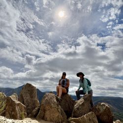
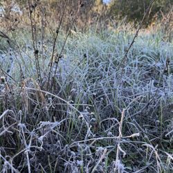
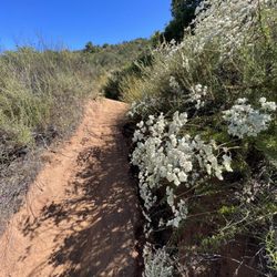
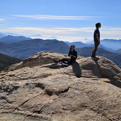
Secret Canyon Trail Photos


You might also consider
More like Secret Canyon Trail
Recommended Reviews - Secret Canyon Trail
Start your review...

9 years ago
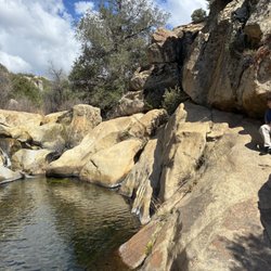
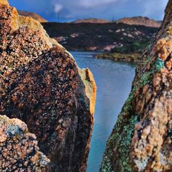
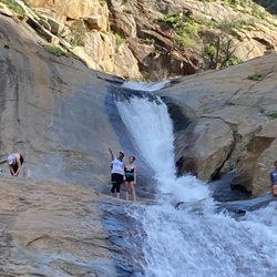
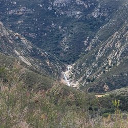
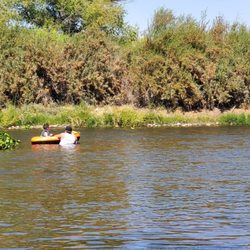
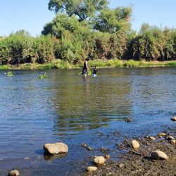
Alltrails lists this as 'Horse thief Canyon', then I saw that I had this listing bookmarked on Yelp for sometime and noticed that they were the same thing! Distance: ~3.3mi., reverse out-and-back (you will be going uphill on the return trip) Difficulty: easy-intermediate-ish (~0.5mi ascent on your way out which can get the heart pumping!) Time: 1.5-2 hours Permit required?: No (according to permit site - https://www.fs.usda.gov/detailfull/r5/passes-permits/?cid=stelprdb5208699&width=full) Sights of Interest: Mini waterfall and pool Parking is in a big dirt lot just off of Japatul Lyons Valley Rd.. Turn in at Forest Rt 16S04. No bathrooms, so bring some T.P.! There are three gates as you approach - two smaller ones and a large one leading to a service road. Take the gate with a sign marking the 'Epinosa Trail to Secret Canyon Trail'. You'll end up on the service road either way. Continue on the service road until you see a sign off to the right that says 'Trail'. This is where you'll begin the descent into Horse thief Canyon. Eventually it evens out into a nice shady area alongside a stream. Lots of vegetation and growth everywhere, so make sure to *bring the bug spray*! There's a stream crossing after which you'll come upon the pool! Lots of great places to hang out on and relax on boulders. Water is pretty clean for swimming too. Awesome place to bring your dogs to cool off after the dusty trail. Just remember to pack your trash out if you plan on picnic-ing down at the pool! Most of your journey is on the Epinosa Trail and supposedly the Secret Canyon Trail is just beyond the pool, but the trail doesn't seem to continue anywhere beyond it. Great trail either way that experiences very little foot traffic so the area is very well preserved and wild! FYI, apparently this area experiences an influx of illegal immigrants and smugglers, but I think that was in earlier years. It was pretty safe when I went and I only had my dog in tow. But, I like to live life on the edge, so if you are wary come with a group! read more


7 years ago
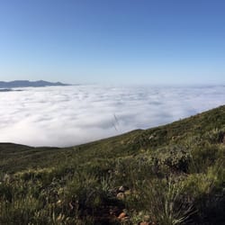
Secret Canyon is AWESOME! Not the most suitable trail if you are looking for broad expansive vistas, but the trail meanders through some amazing local topography and you get to see much undisturbed natural flora. The trail has many warnings about illegal immigrants and smugglers, but for the most part illegal immigration routes have moved eastward and the trail is safe. The trail begins with a big descent into the Pine Creek Wilderness area, then follow the sign to make the turn onto Secret Canyon Trail from the main Espinosa Trail. There are AMAZING stands of old old old and giant Manzanita and old Black Oaks. The stream bed gurgles away below and the trail, while narrow and somewhat technical, is never too steep or difficult. For refreshments after making this hike, head to Alpine Brewery after! SOOOOOO yummy. read more


5 years ago
7 years ago
Loved this hike. I believe it was around 5 miles total from the beginning of the trail down to the pond then back to the top. It was pretty steep coming back up and felt like it took forever but definitely a beautiful hike and a good workout. Highly recommend! read more


9 years ago
More info about Secret Canyon Trail
21697 Lyons Valley Rd
Alpine, CA 91901
Directions
Hours
Outdoor Amenities
Ask the Community - Secret Canyon Trail
You might also consider


Secret Canyon Trail - hiking - Updated July 2026
Best of Alpine
People found Secret Canyon Trail by searching for…
Things to Do in Alpine, California
Waterfall Hike in Alpine, California
Natural Hot Springs in Alpine, California
Hiking Trails in Alpine, California
Off Road Trails in Alpine, California
Places to Take Pictures in Alpine, California
Wildflowers in Alpine, California
Dog Swimming in Alpine, California
Picnic Spots in Alpine, California
Secret Spots in Alpine, California
Waterfalls in Alpine, California
Running Trails in Alpine, California
Walking Trails in Alpine, California
Watch Sunset in Alpine, California
Lakes & Ponds in Alpine, California
Hiking With Kids in Alpine, California
Dog Friendly Trails in Alpine, California
Sunset View in Alpine, California
Canyoneering in Alpine, California
Hiking Club in Alpine, California
Picnic Areas in Alpine, California
Trending Searches in Alpine, CA
Browse Articles
Browse Nearby
Browse Brands
Related Searches in Alpine, CA
Affordable Kayak Rental Services in Alpine, California
Best Fishing Locations and Guides in Alpine, California
Best Nature Trails for Hiking in Alpine, California
Best Places for Horseback Riding in Alpine, California
Best Waterfalls and Swimming Holes in Alpine, California
Check Out Off Road Trails in Alpine, California
Discover Dog Friendly Trails to Explore in Alpine, California
Discover Scenic Hiking Trails in Alpine, California
Discover Scenic Mountain Bike Trails Near Alpine, California
Discover Walking Parks in Alpine, California Near You
Discover a Hiking Trail in Alpine, California
Discover the Best Night Hike Trails in Alpine, California
Dog-Friendly Hikes With Dogs in Alpine, California
Enjoy Camping Adventures Around Alpine, California
Enjoy Exciting Mountain Biking Adventures in Alpine, California
Enjoy Kayaking Adventures in Alpine, California
Enjoy Tent Camping Spots Around Alpine, California
Enjoy a Beautiful Waterfall Hike in Alpine, California
Enjoy a Peaceful Nature Walk in Alpine, California
Enjoy the Best Picnic Spots and Ideas in Alpine, California
Enjoy the Best Walking Path in Alpine, California
Enjoy the Best Walking Trails in Alpine, California
Exciting Cliff Jumping Spots in Alpine, California
Explore Beautiful Parks and Green Spaces in Alpine, California
Explore Easy Hikes Perfect for All in Alpine, California
Explore Fun Activities to Do in Alpine, California
Explore Popular Campgrounds Near Alpine, California
Explore the Best Beach Spots in Alpine, California
Explore the Best Trail Options in Alpine, California
Family Friendly Hiking With Kids in Alpine, California
Find Beautiful Views in Alpine, California
Find Popular Ziplining Spots Around Alpine, California
Find the Best Parks for Picnics in Alpine, California
Find the Best Scenic View Locations in Alpine, California
Great Places to Walk in Alpine, California
Hike the Popular Waterfall Trail in Alpine, California
Hiking Trails With Waterfalls in Alpine, California
Off Leash Dog Hiking Trails in Alpine, California
Popular Outdoor Activities to Try in Alpine, California
Popular Picnic Spots to Visit in Alpine, California
Safe River Swimming Areas in Alpine, California
Safe and Fun Parks for Kids in Alpine, California
Top Climbing Spots and Gyms in Alpine, California
Top Paddleboarding Activities in Alpine, California
Top Places for Snorkeling in Alpine, California
Top Running Trails to Explore in Alpine, California
Top Swimming Lakes to Enjoy in Alpine, California
Top Swimming Spots and Pools in Alpine, California
People who viewed Secret Canyon Trail also viewed
McGinty Mountain
19 reviews
El Cajon Mountain Hiking Trail
140 reviews
Oak Canyon Trail
25 reviews
Historic Flume Trailhead
2 reviews
Blossom Valley
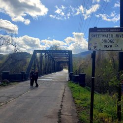
Sweetwater River Bridge
37 reviews
Lakeside Linkage Preserve
1 review
North Fortuna Summit
10 reviews
La Mesa Public Stairs
72 reviews
Shadow mountain Trails
1 review
Lawson Peak Trail
9 reviews