Sweetwater River Bridge Photos


You might also consider
More like Sweetwater River Bridge
Recommended Reviews - Sweetwater River Bridge
Start your review...

Reviews With Photos

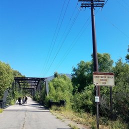
Great place tucked away in San Diego that is essentially a hidden gem. Unfortunately, we surpassed this spot by 10 miles as Google had us and the end of the park. This park is long and at one end is this bridge that was built in 1929, there is a lovely sign and many come here to take pictures. There is also another couple of bridges during your hike through the fields. Upon arriving a motorcyclist parked his bike at one entrance to take pictures, on the way back from our hike, a couple had a tripod setup for pictures. Oh yes, we got our picture on too!!!

This is one of the most peaceful walks you will ever go on. Not everyone loves hiking and there's nothing wrong with that. This walk is for my non hikers. It is such a beautiful, calm, relaxing trail here. I love how quiet is it. If you're scared of anything steep, don't worry. This walk is fairly easy and not at all challenging. My favorite times to come are early in the morning or around 11ish. Parking is easy and free. Sometimes people take pictures by the bridge. Pro tip, do not wear shoes you like! They will definitely get dirty.

Nice bridge! Parking can get a bit crowded. We went on a weekend AM and had to park off the busy highway street.. The bridge connects to a hiking trail. Very family friendly. We brought our 3 yr old and he did fine, got a bit tired but we also had a hiking bag. There are lots of mountain bikers on this trail. Also plenty of neat surprises like the river running through! There is also plenty of shopping centers and restaurants near by so its easy to grab a bite after a hike.
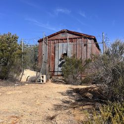
Unless you're having your portrait or family pictures taken this isn't a destination. Think of the Sweetwater River Bridge as something to check out if you're in the area. Parking lot is right off Campo road. If you're not hiking the gauntlet 8 mile hike to Mother Miguel Mountain then figure about 15 minutes to walk to the end of the bridge and back, maybe with a stop or two for pictures. - This is also the place where skunks that were captured in the surrounding neighborhoods get returned to the wild. Almost 300 skunks have been returned here.

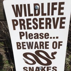
This was my first time here and it's a nice place for people of all ages. The trail itself is a loop but you don't have to do the loop it splinters off into other little trails and there is a lot to explore. I saw birds, rabbits, squirrels a lizard and two different snakes... one non venomous and the other was a baby rattlesnake. It's really beautiful and full of color st the moment. I'd definitely recommend checking it out before summer and if you go during the summer go early. Hours are sunrise to sunset.


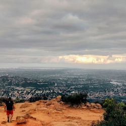
It's one of most gorgeous local trails I've been. It's great for anything: hiking, running, walking. It feels like you're far away from the city, being literally 10 min away only. If you go for a run, you'll get your 5 miles work out. And the bridge at the beginning is just gorgeous. I would definitely pick it for my Photo session!


I would definitly say this is hidden gem in rancho san diego , easy access from campo road , its across the St. from tgi & ymca , it do have limited parking but its not a busy spot , i really loved the place i kept walking in depth till i arrive behind the houses on the mountain in spring valley on lake point drive which was interesting & cool but had to go back since i was alone & there was no signs , there is i would say 2 paths to go , the path i took they say it would go all the way to bonita . I think there should be more signs at least in case of bad thing happen & you needed to call 911 you can let them know where on earth are you coz i walked 60 minute in depth and i took rights & lefts climbed some hills and there was couple times of high inclined down hills which can turn out to be bad experience if you lose stability and roll down . I would go back next week to try different route , i just hope that there is someone with me to make it more fun and safer . I wouldnt recommend you to hike in depth alone , all the people were in groups and didnt see anyone going more than 15 minutes in depth at least the route i took although i saw some foot trails on sand . There is a small nice pond & bridge , after 10 minutes walking you will not hear any street sounds just fresh air and excellent views. Make sure to lock car & dont leave things of value on sight coz someone might broke into your car .

Very pretty place to have a nice hike. To be honest I did take a wrong turn at some point and ended on a jeep trail. It was very pretty though. Some obvious pointers but not that obvious for beginner hikers like me, there's no trash cans on the trail, just in the beginning area. There are obviously ticks but that's something I didn't really keep kind mind of; my dog and I got 5 ticks total. It was bad. Anyway, very pretty nature and it's serene. Just keep track of where you're going and stay conscious about insects & ur all good.

Very nice, well maintained trails. There are a bunch of different paths to take. Not a lot of tree cover so I would recommend bringing water and a hat. Plenty of parking in the lot outside the trail or in front of the bridge which is also cool to walk across. read more


6 months ago
3 years ago
Great place tucked away in San Diego that is essentially a hidden gem. Unfortunately, we surpassed this spot by 10 miles as Google had us and the end of the park. This park is long and at one end is this bridge that was built in 1929, there is a lovely sign and many come here to take pictures. There is also another couple of bridges during your hike through the fields. Upon arriving a motorcyclist parked his bike at one entrance to take pictures, on the way back from our hike, a couple had a tripod setup for pictures. Oh yes, we got our picture on too!!! read more


4 years ago
This is one of the most peaceful walks you will ever go on. Not everyone loves hiking and there's nothing wrong with that. This walk is for my non hikers. It is such a beautiful, calm, relaxing trail here. I love how quiet is it. If you're scared of anything steep, don't worry. This walk is fairly easy and not at all challenging. My favorite times to come are early in the morning or around 11ish. Parking is easy and free. Sometimes people take pictures by the bridge. Pro tip, do not wear shoes you like! They will definitely get dirty. read more

Nice bridge! Parking can get a bit crowded. We went on a weekend AM and had to park off the busy highway street.. The bridge connects to a hiking trail. Very family friendly. We brought our 3 yr old and he did fine, got a bit tired but we also had a hiking bag. There are lots of mountain bikers on this trail. Also plenty of neat surprises like the river running through! There is also plenty of shopping centers and restaurants near by so its easy to grab a bite after a hike. read more


Unless you're having your portrait or family pictures taken this isn't a destination. Think of the Sweetwater River Bridge as something to check out if you're in the area. Parking lot is right off Campo road. If you're not hiking the gauntlet 8 mile hike to Mother Miguel Mountain then figure about 15 minutes to walk to the end of the bridge and back, maybe with a stop or two for pictures. - This is also the place where skunks that were captured in the surrounding neighborhoods get returned to the wild. Almost 300 skunks have been returned here. read more


This was my first time here and it's a nice place for people of all ages. The trail itself is a loop but you don't have to do the loop it splinters off into other little trails and there is a lot to explore. I saw birds, rabbits, squirrels a lizard and two different snakes... one non venomous and the other was a baby rattlesnake. It's really beautiful and full of color st the moment. I'd definitely recommend checking it out before summer and if you go during the summer go early. Hours are sunrise to sunset. read more


4 years ago
The bridge was built in 1929 pretty cool to see got that out-of-the-way water under the bridge lol read more


It's one of most gorgeous local trails I've been. It's great for anything: hiking, running, walking. It feels like you're far away from the city, being literally 10 min away only. If you go for a run, you'll get your 5 miles work out. And the bridge at the beginning is just gorgeous. I would definitely pick it for my Photo session! read more


4 years ago
First time coming to this hike with my boyfriend. Before starting our hike we found black bags with headless goats on the side of the parking lot. We don't know what the goats were used for. Just be careful when coming here alone and at night. read more


9 years ago
I would definitly say this is hidden gem in rancho san diego , easy access from campo road , its across the St. from tgi & ymca , it do have limited parking but its not a busy spot , i really loved the place i kept walking in depth till i arrive behind the houses on the mountain in spring valley on lake point drive which was interesting & cool but had to go back since i was alone & there was no signs , there is i would say 2 paths to go , the path i took they say it would go all the way to bonita . I think there should be more signs at least in case of bad thing happen & you needed to call 911 you can let them know where on earth are you coz i walked 60 minute in depth and i took rights & lefts climbed some hills and there was couple times of high inclined down hills which can turn out to be bad experience if you lose stability and roll down . I would go back next week to try different route , i just hope that there is someone with me to make it more fun and safer . I wouldnt recommend you to hike in depth alone , all the people were in groups and didnt see anyone going more than 15 minutes in depth at least the route i took although i saw some foot trails on sand . There is a small nice pond & bridge , after 10 minutes walking you will not hear any street sounds just fresh air and excellent views. Make sure to lock car & dont leave things of value on sight coz someone might broke into your car . read more


5 years ago
6 years ago
5 years ago
5 years ago
Very pretty place to have a nice hike. To be honest I did take a wrong turn at some point and ended on a jeep trail. It was very pretty though. Some obvious pointers but not that obvious for beginner hikers like me, there's no trash cans on the trail, just in the beginning area. There are obviously ticks but that's something I didn't really keep kind mind of; my dog and I got 5 ticks total. It was bad. Anyway, very pretty nature and it's serene. Just keep track of where you're going and stay conscious about insects & ur all good. read more


5 years ago
9 years ago
*HAUNTED AS FUCK AND CREEPY* So today my boyfriend and I both had the day off so I yelped hiking trails nearby to try something new and this Sweetwater River Bridge popped up. We get there and we took photos of the bridge and started on our journey. We weren't even halfway through the bridge and already I felt off. We were laughing because we were thinking it had IT vibes because we had just seen the movie a week ago. We get to the actual trail and it's really narrow and bends a lot where you really can't see more than 10 feet ahead of you. My boyfriend likes straying from trails all the time and he did 5 minutes into this trail and he comes back with nervous eyes and says there's a shoe and boxers just lying on the floor. We both laugh nervously and by this point I felt scared and paranoid like something is watching us. I kept looking around. always a trooper though so he wanted to continue but I turned around and start fast walking to exit the trail. My heart was pounding and I felt really bad vibes. My boyfriend says he feels weird. We get to the bridge and we both start running towards the car. I legit started the car and pulled out of the parking spot so fast. My boyfriend said he's never felt that kind of fear before. I was convinced that this bridge is haunted AF. I googled it and check this fucker out. This hiking trail is #2 on the Top 10 Scariest Trails in San Diego. And there's a description of cryptid humanoid shape on all fours sighted by other hikers. Like fuuuuuuck that shit. We had no idea. It's been 3 hours and I still can't shake off how I felt. I literally have never felt that kind of bad vibes before. It was so scary read more


8 years ago
As a little kid, I'd ride in the bed of my Dads truck and we'd drive across this bridge to go to Puckett's Christmas Tree Farm in Jamul every Xmas. Now I ride across it on my mountain bike to hit the trails and it brings back memories. Beautiful site for wedding/family photos. Just passed a wedding photo shoot today on my bike and congratulated them. read more


9 years ago
8 years ago
I had a photo shoot here a few weeks ago and it was so beautiful! Nice trees and fields led to a great session with this sweet couple. The bridge also makes for great pictures! read more


10 years ago
Awesome place for photographs. The bridge is great for bringing in some architecture and nearby trails allow for great backdrops to photographs. I'll be heading back here again in the near future. read more


8 years ago
6 years ago
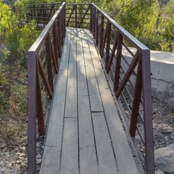
I love this trail! It's awesome because there are so many trails you can do. Basically it starts off as a head trail (a couple hundred feet after the bridge to your right), then it branches off into Mount Miguel's trail, you can take the loop by going over another bridge (wooden), you can also take this jeep trail that's my favorite to take my dogs because it's wider and isn't near any poison oak. I'm sure there are many more trails because I see different trails when I pass by and one that also is to the left of Steele canyon bridge that goes to water towers I hear is cool too. But a few things I want to make people aware of because I always see tourists and those who don't know a lot of important things with hiking. THERE IS POISON OAK EVERYWHERE. So please be cautious when you see bushes with 3 leaves and look oily and they'll have bumpy sides. There's a trail that takes you to the creek which is great except a couple of them are overgrown with poison oak that people walk right through not noticing. Also, BEWARE OF RATTLESNAKES. Please keep your dog on a leash especially during summer. I just went out the other day and finally saw one. But I hear them rattling all the time. My brother runs these trails everyday and sees a rattlesnake every other day. Another thing is to keep expensive or stuff that is valuable in your trunk because I hear of break ins all the time and glass shards are always on the ground. Please have fun but be cautious. (I didn't get a photo of the rattlesnake but this is what poison oak looks like.) read more


10 years ago
Careful leaving items in your car ladies! Came back from an 8 mile hike to find my window busted and my purse stolen! Put your valuables in your trunk!!! read more


9 years ago
9 years ago
9 years ago
9 years ago
10 years ago
More info about Sweetwater River Bridge
2951 Jamacha Rd
El Cajon, CA 92019
Directions
Hours
Outdoor Amenities
Ask the Community - Sweetwater River Bridge
Best time to go and take pictures on a weekend?
Early morning as the east sun is rising to mid morning or dusk.
Review Highlights - Sweetwater River Bridge
You might also consider


Why does Yelp recommend reviews?
1 review that is not currently recommended
The reviews below are not factored into the business's overall star rating.
4 years ago
Sweetwater River Bridge - hiking - Updated May 2026
Best of El Cajon
People found Sweetwater River Bridge by searching for…
Things to Do in El Cajon, California
Places to Take Pictures in El Cajon, California
Beautiful Views in El Cajon, California
Hiking Trails in El Cajon, California
Walking Trails in El Cajon, California
River Swimming in El Cajon, California
Night View in El Cajon, California
Photo Spots in El Cajon, California
Swimming Lakes in El Cajon, California
Running Trails in El Cajon, California
Places to Walk in El Cajon, California
Secret Spots in El Cajon, California
Lakes & Ponds in El Cajon, California
Easy Hikes in El Cajon, California
Watch Sunset in El Cajon, California
Off Road Trails in El Cajon, California
Dog Friendly Hiking Trails in El Cajon, California
Bridge in El Cajon, California
Off Leash Dog Hiking Trails in El Cajon, California
Parks for Kids in El Cajon, California
Scenic View in El Cajon, California
Trending Searches in El Cajon, CA
Botanical Gardens near Sweetwater River Bridge
Bounce House Rentals near Sweetwater River Bridge
Campgrounds near Sweetwater River Bridge
Cherry Picking near Sweetwater River Bridge
Cliff Jumping near Sweetwater River Bridge
Dog Friendly Things To Do near Sweetwater River Bridge
Dog Friendly Trails near Sweetwater River Bridge
Flower Fields near Sweetwater River Bridge
Flower Shop near Sweetwater River Bridge
Free Picnic Areas near Sweetwater River Bridge
Garage Sales near Sweetwater River Bridge
Garden Center near Sweetwater River Bridge
Hair near Sweetwater River Bridge
Hiking near Sweetwater River Bridge
Lakes & Ponds near Sweetwater River Bridge
Lookout Points near Sweetwater River Bridge
Nurseries & Gardening near Sweetwater River Bridge
Outdoor Activities near Sweetwater River Bridge
Outdoor Furniture Stores near Sweetwater River Bridge
Parks near Sweetwater River Bridge
Party Equipment Rentals near Sweetwater River Bridge
Pedicure near Sweetwater River Bridge
Photo Spots near Sweetwater River Bridge
Pick Your Own Farms near Sweetwater River Bridge
Picnic Areas near Sweetwater River Bridge
Places To Take Pictures near Sweetwater River Bridge
Rock Quarry near Sweetwater River Bridge
Running Trails near Sweetwater River Bridge
Scenic Night View near Sweetwater River Bridge
Scenic Places To Walk near Sweetwater River Bridge
Secluded Spots near Sweetwater River Bridge
Star Gazing near Sweetwater River Bridge
Strawberry Picking near Sweetwater River Bridge
Sunrise View near Sweetwater River Bridge
Swimming Holes near Sweetwater River Bridge
Table And Chair Rentals near Sweetwater River Bridge
Walking Trails near Sweetwater River Bridge
Browse Nearby
BEST of El Cajon, California Walking Trails near Sweetwater River Bridge
BEST of El Cajon, California Coffee near Sweetwater River Bridge
BEST of El Cajon, California Restaurants near Sweetwater River Bridge
BEST of El Cajon, California Things to Do near Sweetwater River Bridge
BEST of El Cajon, California Parks near Sweetwater River Bridge
BEST of El Cajon, California Breakfast near Sweetwater River Bridge
BEST of El Cajon, California Campgrounds near Sweetwater River Bridge
BEST of El Cajon, California Hotels near Sweetwater River Bridge
Browse Brands
Related Searches in El Cajon, CA
Affordable Bike Repair Services in El Cajon, California
Affordable Bike Tune Up Services in El Cajon, California
Affordable Kayak Rental Services in El Cajon, California
Affordable Mobile Bike Repair in El Cajon, California
Affordable Road Bike Rental in El Cajon, California
Best Dog Hiking Trails Around El Cajon, California
Best Electric Bike Rental Services in El Cajon, California
Best Fishing Locations and Guides in El Cajon, California
Best Places for Horseback Riding in El Cajon, California
Best Sledding Spots and Fun in El Cajon, California
Best Used Bikes for Sale Near El Cajon, California
Best Waterfalls and Swimming Holes in El Cajon, California
Check Out Off Road Trails in El Cajon, California
Discover Dog Friendly Trails to Explore in El Cajon, California
Discover Popular Bike Tours in El Cajon, California
Discover Scenic Bike Paths in El Cajon, California
Discover Scenic Mountain Bike Trails Near El Cajon, California
Discover Walking Parks in El Cajon, California Near You
Discover a Hiking Trail in El Cajon, California
Discover the Best Night Hike Trails in El Cajon, California
Discover the Best Running Track in El Cajon, California
Dog-Friendly Hikes With Dogs in El Cajon, California
Enjoy Biking Adventures Around El Cajon, California
Enjoy Camping Adventures Around El Cajon, California
Enjoy Exciting Mountain Biking Adventures in El Cajon, California
Enjoy Hiking Adventures in El Cajon, California
Enjoy Kayaking Adventures in El Cajon, California
Enjoy Tent Camping Spots Around El Cajon, California
Enjoy a Beautiful Waterfall Hike in El Cajon, California
Enjoy a Peaceful Nature Walk in El Cajon, California
Enjoy the Best Picnic Spots and Ideas in El Cajon, California
Enjoy the Best Tubing Experiences in El Cajon, California
Enjoy the Best Walking Path in El Cajon, California
Enjoy the Best Walking Trails in El Cajon, California
Exciting Cliff Jumping Spots in El Cajon, California
Explore BMX Bike Shops Near El Cajon, California
Explore Beautiful Mountains and Hiking Spots in El Cajon, California
Explore Beautiful Parks and Green Spaces in El Cajon, California
Explore Bike Rentals Throughout El Cajon, California
Explore Easy Hikes Perfect for All in El Cajon, California
Explore Electric Bikes Available in El Cajon, California
Explore Fun Activities to Do in El Cajon, California
Explore Popular Campgrounds Near El Cajon, California
Explore Popular Scenic Overlook Points in El Cajon, California
Explore Scenic Lakes to Visit in El Cajon, California
Explore Secret Spots Worth Visiting in El Cajon, California
Explore the Best Beach Spots in El Cajon, California
Explore the Best Trail Options in El Cajon, California
Browse Articles
People who viewed Sweetwater River Bridge also viewed
Walker Preserve
26 reviews
Hollenbeck Canyon Wildlife Area
20 reviews
Viejas Mountain
14 reviews
Navajo Canyon Open Space
11 reviews
Del Cerro
Lake Murray
334 reviews
Oak Canyon Trail
24 reviews
Lakeside's River Park
10 reviews
McGinty Mountain
19 reviews
Dead Horse Falls Trail
4 reviews
Eucalyptus County Park
32 reviews