McGinty Mountain Photos


You might also consider
More like McGinty Mountain
Recommended Reviews - McGinty Mountain
Start your review...

Reviews With Photos

It's a decent hike. I liked that it is not very crowded/popular. It is an out and back trail. It is steep up enough to give you a decent workout without it being miserable. The views are pretty good at the top but rather average on most of the hike. There is a decent size parking area and the trail isn't too confusing to follow Distance 4.7 miles Duration 2 to 3 hrs Elevation Gain 1,300 ft

We will definitely do this trail again. We arrived at 830am and did half the trail which took about and hour there and back. The trail is 90% incline and rocky. There were only two other people on the trail with us. Nice views of El Cajon and Rancho San Diego. Did not see any snakes but there were tons of lizards and bees! Only downside was that people didn't pick up after their dogs so we had to avoid a lot of dog poop.


This is a good hike. I'm beginning to run out of new places near El Cajon I can hike before I have to drive further and further out. Desperate for something new and close by with a moderate to hard difficulty, I stumbled upon this trail on Alltrails.com. :) I rate my trails based on a few things: Difficulty (I'm a regular hiker FYI), scenery, quaintness, traffic, and other things like the flora and fauna. Difficulty: easy moderate. Length is only 5 miles to the peak and back. Once you hit the last stretch to the peak it gets a bit steep, nothing terrible. Just remember though, if you aren't a regular hiker it may be more difficult. Traffic: Low. Saw most people Sunday afternoon as I was heading back, which was about 3-4 parties. 6 parties total. Landscape: high brush desert Elevation Gain: 1020 ft Length: 5 mi to peak and back Scenery: Not the best I've seen. There are houses surrounding the trail's preserve. Beyond that though, a great view of San Diego area and the surrounding mountains. Typical of the area. Quaintness: Not the best either. I like it very quiet, with hardly the note of civilization in the air. Not possible on this hike. Dogs barking, car alarms, moving vehicles... You hear what's happening below. Flora and Fauna: Very good for the area. Lots of birds singing, I saw a rabbit and lots of lizards. Flowers were blooming today. I don't know what plant species it was but something was smelling like freshly made Mexican tortillas, making me hungry. :P I rate this hike 3 stars due to the fact that it didn't stand out to me enough to desire a return hike. I would, however, recommend doing it once at the very least if you live in SD and want to find a different hike to try!


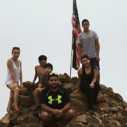
I'm not an experienced hiker and didn't make it to the top, but I loved that at almost any point, there were beautiful views. I gave it 4 stars because there was barely any shade. It was hot, it's August and 90 degrees. Better not to go in the summer. But, it was still worth it to me. When you get closer to the top it's pretty steep.

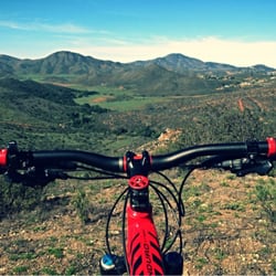
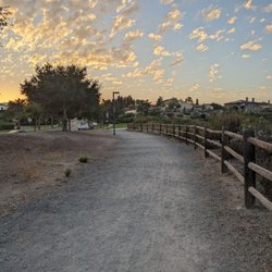
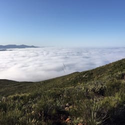
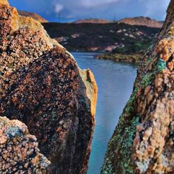
McGinty Mountain is a beautiful hiking trail in San Diego County, California, near Jamul. On my morning hike, the ample shade on the way up made the experience pleasant. The trail features red soil, a variety of plant species, and stunning panoramic mountain views. There's a parking lot at the trailhead, and the trail is dog-friendly. This well-maintained mountain is part of an ecological preserve managed by The Nature Conservancy, the California Department of Fish and Wildlife, and the San Diego National Wildlife Refuge. The trail is a 4.7-mile (7.6 km) out-and-back route, reaching a peak elevation of 2,185 feet. read more


11 months ago
2 years ago
It's a decent hike. I liked that it is not very crowded/popular. It is an out and back trail. It is steep up enough to give you a decent workout without it being miserable. The views are pretty good at the top but rather average on most of the hike. There is a decent size parking area and the trail isn't too confusing to follow Distance 4.7 miles Duration 2 to 3 hrs Elevation Gain 1,300 ft read more


5 years ago
We will definitely do this trail again. We arrived at 830am and did half the trail which took about and hour there and back. The trail is 90% incline and rocky. There were only two other people on the trail with us. Nice views of El Cajon and Rancho San Diego. Did not see any snakes but there were tons of lizards and bees! Only downside was that people didn't pick up after their dogs so we had to avoid a lot of dog poop. read more


7 years ago
Small unpaved but free parking lot at the trailhead. The trail is quite uneven most of the way. The most interesting part about the hike is the views that open up on top. read more


This is a good hike. I'm beginning to run out of new places near El Cajon I can hike before I have to drive further and further out. Desperate for something new and close by with a moderate to hard difficulty, I stumbled upon this trail on Alltrails.com. :) I rate my trails based on a few things: Difficulty (I'm a regular hiker FYI), scenery, quaintness, traffic, and other things like the flora and fauna. Difficulty: easy moderate. Length is only 5 miles to the peak and back. Once you hit the last stretch to the peak it gets a bit steep, nothing terrible. Just remember though, if you aren't a regular hiker it may be more difficult. Traffic: Low. Saw most people Sunday afternoon as I was heading back, which was about 3-4 parties. 6 parties total. Landscape: high brush desert Elevation Gain: 1020 ft Length: 5 mi to peak and back Scenery: Not the best I've seen. There are houses surrounding the trail's preserve. Beyond that though, a great view of San Diego area and the surrounding mountains. Typical of the area. Quaintness: Not the best either. I like it very quiet, with hardly the note of civilization in the air. Not possible on this hike. Dogs barking, car alarms, moving vehicles... You hear what's happening below. Flora and Fauna: Very good for the area. Lots of birds singing, I saw a rabbit and lots of lizards. Flowers were blooming today. I don't know what plant species it was but something was smelling like freshly made Mexican tortillas, making me hungry. :P I rate this hike 3 stars due to the fact that it didn't stand out to me enough to desire a return hike. I would, however, recommend doing it once at the very least if you live in SD and want to find a different hike to try! read more


8 years ago
5 years ago
14 years ago
9 years ago
Awesome hike with plenty to see. Take it easy on the McGinty trail or hook left and take the full 19 mile 15 sub trail loop. BRING A MAP! read more


13 years ago
17 years ago
11 years ago
I'm not an experienced hiker and didn't make it to the top, but I loved that at almost any point, there were beautiful views. I gave it 4 stars because there was barely any shade. It was hot, it's August and 90 degrees. Better not to go in the summer. But, it was still worth it to me. When you get closer to the top it's pretty steep. read more


15 years ago
The beginning was very plush with weeds. The trail is very unkempt so be prepared to not see a clear dirt path or follow an easily accessible trail. There was no one else on the trail and it was very confusing, especially when coming down so be careful. It does have some nice places to sit around or maybe even camp once you're closer to the top. read more


11 years ago
11 years ago
More info about McGinty Mountain
Skyline truck trail
Jamul, CA 91935
Directions
Hours
Outdoor Amenities
Ask the Community - McGinty Mountain
Review Highlights - McGinty Mountain
You might also consider


Why does Yelp recommend reviews?
3 reviews that are not currently recommended
The reviews below are not factored into the business's overall star rating.
6 years ago
10 years ago
14 years ago
McGinty Mountain - hiking - Updated July 2026
Best of Jamul
People found McGinty Mountain by searching for…
Beautiful Views in Jamul, California
Things to Do in Jamul, California
Hiking Trails in Jamul, California
Scenic View in Jamul, California
Walking Trails in Jamul, California
Off Road Trails in Jamul, California
Dog Friendly Hiking Trails in Jamul, California
Fishing Lake in Jamul, California
Off Leash Dog Hiking Trails in Jamul, California
Running Trails in Jamul, California
Places to Run in Jamul, California
Free Campgrounds in Jamul, California
View Points in Jamul, California
Shaded Hike in Jamul, California
Natural Hot Springs in Jamul, California
Cave Tour in Jamul, California
Lakes & Ponds in Jamul, California
Scenic Overlook in Jamul, California
Trending Searches in Jamul, CA
Browse Articles
Browse Nearby
BEST of Jamul, California Restaurants near McGinty Mountain
BEST of Jamul, California Things to Do near McGinty Mountain
BEST of Jamul, California Coffee near McGinty Mountain
BEST of Jamul, California Breakfast near McGinty Mountain
BEST of Jamul, California Shopping near McGinty Mountain
Browse Brands
Related Searches in Jamul, CA
Affordable Kayak Rental Services in Jamul, California
Best Fishing Locations and Guides in Jamul, California
Best Places for Horseback Riding in Jamul, California
Best Waterfalls and Swimming Holes in Jamul, California
Check Out Off Road Trails in Jamul, California
Discover Dog Friendly Trails to Explore in Jamul, California
Discover Scenic Hiking Trails in Jamul, California
Discover Scenic Mountain Bike Trails Near Jamul, California
Discover Walking Parks in Jamul, California Near You
Discover a Hiking Trail in Jamul, California
Discover the Best Night Hike Trails in Jamul, California
Dog-Friendly Hikes With Dogs in Jamul, California
Enjoy Camping Adventures Around Jamul, California
Enjoy Exciting Mountain Biking Adventures in Jamul, California
Enjoy Kayaking Adventures in Jamul, California
Enjoy Tent Camping Spots Around Jamul, California
Enjoy a Beautiful Waterfall Hike in Jamul, California
Enjoy a Peaceful Nature Walk in Jamul, California
Enjoy the Best Picnic Spots and Ideas in Jamul, California
Enjoy the Best Walking Path in Jamul, California
Enjoy the Best Walking Trails in Jamul, California
Exciting Cliff Jumping Spots in Jamul, California
Explore Beautiful Parks and Green Spaces in Jamul, California
Explore Easy Hikes Perfect for All in Jamul, California
Explore Fun Activities to Do in Jamul, California
Explore Popular Campgrounds Near Jamul, California
Explore the Best Beach Spots in Jamul, California
Explore the Best Trail Options in Jamul, California
Family Friendly Hiking With Kids in Jamul, California
Find Beautiful Views in Jamul, California
Find Popular Ziplining Spots Around Jamul, California
Find the Best Parks for Picnics in Jamul, California
Find the Best Scenic View Locations in Jamul, California
Great Places to Walk in Jamul, California
Hike the Popular Waterfall Trail in Jamul, California
Hiking Trails With Waterfalls in Jamul, California
Off Leash Dog Hiking Trails in Jamul, California
Plan a Scenic Drive Route Near Jamul, California
Popular Outdoor Activities to Try in Jamul, California
Popular Picnic Spots to Visit in Jamul, California
Safe River Swimming Areas in Jamul, California
Safe and Fun Parks for Kids in Jamul, California
Top Climbing Spots and Gyms in Jamul, California
Top Paddleboarding Activities in Jamul, California
Top Places for Snorkeling in Jamul, California
Top Running Trails to Explore in Jamul, California
Top Swimming Lakes to Enjoy in Jamul, California
Top Swimming Spots and Pools in Jamul, California
People who viewed McGinty Mountain also viewed
Viejas Mountain
14 reviews
Secret Canyon Trail
6 reviews
Navajo Canyon Open Space
11 reviews
Del Cerro
Crestridge Ecological Reserve
6 reviews
Loveland Reservior
7 reviews
Lakeside's River Park
11 reviews
East Fortuna Equestrian Staging Area
9 reviews
Shadow mountain Trails
1 review
Santee Boulders
14 reviews
Silverwood Wildlife Sanctuary
14 reviews