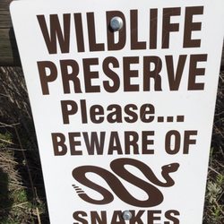
Shadow mountain Trails Photos

You might also consider
More like Shadow mountain Trails
Recommended Reviews - Shadow mountain Trails
Start your review...

13 years ago
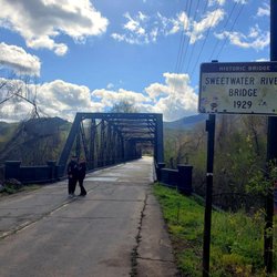
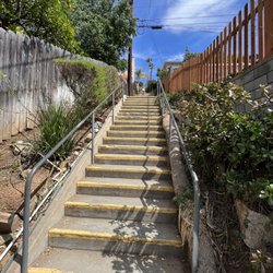
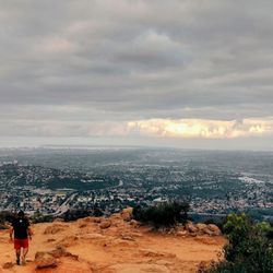
This is a great place to trail run and mountain bike! There is the main fire road that goes all the way up to Crest. There are hiking trails that branch off from the fire road. I see rock climbers, but I'm not sure where they are climbing. This isn't as steep as Cowles mountain, but it's much more peaceful! The goal for trail runners is to make it all the way up to Crest. Don't forget to try and sprint Mike's hill! read more


More info about Shadow mountain Trails
2590 Camino Monte Sombra
El Cajon, CA 92019
Directions
Hours
Outdoor Amenities
You might also consider


Why does Yelp recommend reviews?
1 review that is not currently recommended
The reviews below are not factored into the business's overall star rating.
2 years ago
Shadow mountain Trails - hiking - Updated July 2026
Best of El Cajon
People found Shadow mountain Trails by searching for…
Hiking Trails in El Cajon, California
Walking Trails in El Cajon, California
Things to Do in El Cajon, California
Off Road Trails in El Cajon, California
Running Trails in El Cajon, California
Trails in El Cajon, California
Security Services in El Cajon, California
Mountain Biking in El Cajon, California
Things to Do at Night in El Cajon, California
Places to Run in El Cajon, California
Waterfall in El Cajon, California
Night Walk in El Cajon, California
Places to Walk at Night in El Cajon, California
Attractions in El Cajon, California
Fun Things to Do This Weekend in El Cajon, California
Places to Walk in El Cajon, California
Shaded Hike in El Cajon, California
Off Leash Dog Hikes in El Cajon, California
Fun Things to Do on a Friday Night in El Cajon, California
Walking Groups in El Cajon, California
Real Estate Agents in El Cajon, California
Trending Searches in El Cajon, CA
4th Of July Fireworks near Shadow mountain Trails
Black Owned Nail Salons near Shadow mountain Trails
Boat Rental near Shadow mountain Trails
Cliff Jumping near Shadow mountain Trails
Day Trips near Shadow mountain Trails
Dog Friendly Trails near Shadow mountain Trails
Fireworks near Shadow mountain Trails
Jet Ski Rental near Shadow mountain Trails
Kayak Rental near Shadow mountain Trails
Lakes & Ponds near Shadow mountain Trails
Outdoor Activities near Shadow mountain Trails
Places To Walk Around near Shadow mountain Trails
Public Pools near Shadow mountain Trails
Public Shower near Shadow mountain Trails
Rock Quarry near Shadow mountain Trails
Running Trails near Shadow mountain Trails
Scenic Night View near Shadow mountain Trails
Scenic Overlook near Shadow mountain Trails
Secluded Spots near Shadow mountain Trails
Soccer Store near Shadow mountain Trails
Splash Pad near Shadow mountain Trails
Strawberry Picking near Shadow mountain Trails
Sunrise View near Shadow mountain Trails
Swimming Holes near Shadow mountain Trails
Swimming Lakes near Shadow mountain Trails
Swimming Pools near Shadow mountain Trails
Watch Sunset near Shadow mountain Trails
Browse Articles
Browse Nearby
BEST of El Cajon, California Coffee near Shadow mountain Trails
BEST of El Cajon, California Restaurants near Shadow mountain Trails
BEST of El Cajon, California Things to Do near Shadow mountain Trails
BEST of El Cajon, California Parks near Shadow mountain Trails
BEST of El Cajon, California Breakfast near Shadow mountain Trails
BEST of El Cajon, California Lakes near Shadow mountain Trails
BEST of El Cajon, California Campgrounds near Shadow mountain Trails
BEST of El Cajon, California Motel near Shadow mountain Trails
Browse Brands
Related Searches in El Cajon, CA
Affordable Kayak Rental Services in El Cajon, California
Best Fishing Locations and Guides in El Cajon, California
Best Places for Horseback Riding in El Cajon, California
Best Waterfalls and Swimming Holes in El Cajon, California
Check Out Off Road Trails in El Cajon, California
Discover Dog Friendly Trails to Explore in El Cajon, California
Discover Scenic Mountain Bike Trails Near El Cajon, California
Discover Walking Parks in El Cajon, California Near You
Discover a Hiking Trail in El Cajon, California
Discover the Best Night Hike Trails in El Cajon, California
Discover the Best Running Track in El Cajon, California
Dog-Friendly Hikes With Dogs in El Cajon, California
Enjoy Camping Adventures Around El Cajon, California
Enjoy Exciting Mountain Biking Adventures in El Cajon, California
Enjoy Kayaking Adventures in El Cajon, California
Enjoy Tent Camping Spots Around El Cajon, California
Enjoy a Beautiful Waterfall Hike in El Cajon, California
Enjoy a Peaceful Nature Walk in El Cajon, California
Enjoy the Best Picnic Spots and Ideas in El Cajon, California
Enjoy the Best Walking Path in El Cajon, California
Enjoy the Best Walking Trails in El Cajon, California
Exciting Cliff Jumping Spots in El Cajon, California
Explore Beautiful Parks and Green Spaces in El Cajon, California
Explore Easy Hikes Perfect for All in El Cajon, California
Explore Fun Activities to Do in El Cajon, California
Explore Popular Campgrounds Near El Cajon, California
Explore the Best Beach Spots in El Cajon, California
Explore the Best Trail Options in El Cajon, California
Family Friendly Hiking With Kids in El Cajon, California
Find Beautiful Views in El Cajon, California
Find Popular Ziplining Spots Around El Cajon, California
Find the Best Parks for Picnics in El Cajon, California
Find the Best Scenic View Locations in El Cajon, California
Great Places to Walk in El Cajon, California
Hiking Trails With Waterfalls in El Cajon, California
Off Leash Dog Hiking Trails in El Cajon, California
Plan a Scenic Drive Route Near El Cajon, California
Popular Outdoor Activities to Try in El Cajon, California
Popular Picnic Spots to Visit in El Cajon, California
Safe River Swimming Areas in El Cajon, California
Safe and Fun Parks for Kids in El Cajon, California
Top Climbing Spots and Gyms in El Cajon, California
Top Paddleboarding Activities in El Cajon, California
Top Places for Snorkeling in El Cajon, California
Top Running Trails to Explore in El Cajon, California
Top Swimming Lakes to Enjoy in El Cajon, California
Top Swimming Spots and Pools in El Cajon, California
Top Things to Do With Kids in El Cajon, California
People who viewed Shadow mountain Trails also viewed
Lakeside's River Park
11 reviews
McGinty Mountain
19 reviews
Walker Preserve
26 reviews
Viejas Mountain
14 reviews
Lakeside Linkage Preserve
1 review
Silverwood Wildlife Sanctuary
14 reviews
Santee Boulders
14 reviews
Pyle's Peak
40 reviews
San Carlos
Hollenbeck Canyon Wildlife Area
20 reviews
Lawson Peak Trail
9 reviews