Viejas Mountain Photos


You might also consider
More like Viejas Mountain
Recommended Reviews - Viejas Mountain
Start your review...

Reviews With Photos

Trail is on Anderson Road!!! Off of Victoria! Was very difficult to find, but once we did - it was lovely! Climb is approximately 2.25 straight up. I'd call it moderate to difficult - I'm 47 and in decent shape. Beautiful views of San Diego and to the East. Start early it gets hot on the trail!


Took the doggies on a playdate today and it took us about 2 hours roundtrip, including break at top. I think this hike is under 3 miles, but all incline with little switchbacks...yay! Rocky is definitely an understatement on this one, so watch your footing! The trail is narrow so it helps that it is not crowded. Nice views up top Oh...gps takes you right to the start of trail. Also, be extra cautious with glass near the start of trail. I carried my dog before entering and upon exiting as it was everywhere: )

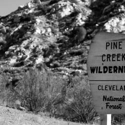
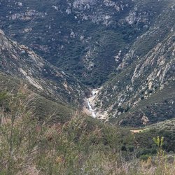
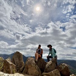
This is an absolutely beautiful peak hike though strenuous because of the vertical lack of switch backs. To access it from the city of Alpine take the Tavern Rd exit off 1-8 fwy. Drive east on Alpine Blvd. turn left on Victoria go up the hill over the fwy about 1.3 miles turn left on Anderson Rd. continue up and the road turns to dirt for .3 miles and is now Anderson Truck Trail to a large turnout where you park. Trail is not marked look for and get ready for a workout up the mountain. Bring plenty of water! I do not recommend this in hot weather or small children. The trail is only 3 miles round trip. It is a 1500 ft. elevation gain. You will be deceived by many parts where you think you will be at the peak but keep going. This is a sacred spot enjoyed by the Indians during summer solstice. When you reach what appears the very top enjoy your view of Viejas Casino below and on a clear day the ocean! Now take the trail to left through chapparal waist high to the true peak and two very cool circular piled high rock wind breaks. Now the view is truly amazing as you now can see virtually forever. Wait now.......bring wine and enjoy the near sunset. But hurry down so as not to go down in the dark.


8 years ago
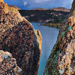
Spectacular views at the summit especially when facing North. Easy to access from Tavern Rd exit on the I-8. It's about 3 miles RT on red-clay dirt and very loose rocks. Although Alltrails lists it as intermediate, I was breathless climbing this thing. I would describe it as intermediate-difficult. I mean, the doughnut holes in the morning probably didn't help and it was after Christmas Day indulgences, but the terrain was still very rocky and the incline was CONSTANT, making the ascent a little more difficult than normal. It was the ultimate thigh burner! A great workout! I took about 2 hours to finish, but did spend a lot of time at the top. Had the summit all to myself! Breath-taking! Parking is on a truck trail and the trail head is only marked by a simple metal gate. According to Afoot and Afield a **Wilderness Pass is technically required**, however I got away without one (didn't realize I needed one). Again, the terrain is quite rocky on the clay dirt ascent, so do not bring your kids! They'll likely fall flat on their faces trying to navigate over the rocks. As a note-- the truck road is a dirt one, but well graded with some humps every so often to prevent speeding. Parking near the trailhead is still quite secluded and a draw for thieves, so make sure to hide your belongings before you head out! read more


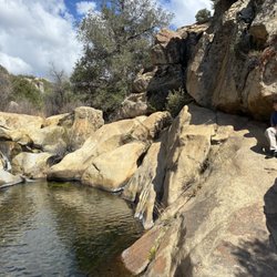
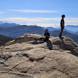
This is my favorite hike in San Diego so far. I've been to El Capitan, iron Mountain, mission trails, and more. The hike is only about 5 miles there and back and the views are beautiful all the way to the top. This mountain definitely has, in my humble opinion, the best view of the San Diego area and Cuyamaca peak by far. It's 4K ft. I highly recommend this hike to anyone looking for a good hike with wonderful 360 degree views. It's quiet and quaint as well. Just beware, there are a lot of loose rocks so be careful while you head down. read more


10 years ago
Trail is on Anderson Road!!! Off of Victoria! Was very difficult to find, but once we did - it was lovely! Climb is approximately 2.25 straight up. I'd call it moderate to difficult - I'm 47 and in decent shape. Beautiful views of San Diego and to the East. Start early it gets hot on the trail! read more


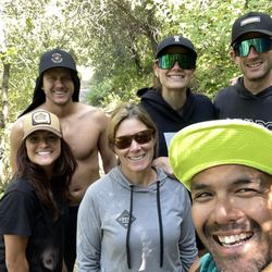
Great hike and views! Recommend hiking boots as it's a technical hike. Use the address and directions in alltrails.com!!!! We hiked up for about 35 mins... u can see our car in the first pic... you go up pretty high and fast, starting already at probably 2500 ft elevation. read more


8 years ago
Took the doggies on a playdate today and it took us about 2 hours roundtrip, including break at top. I think this hike is under 3 miles, but all incline with little switchbacks...yay! Rocky is definitely an understatement on this one, so watch your footing! The trail is narrow so it helps that it is not crowded. Nice views up top Oh...gps takes you right to the start of trail. Also, be extra cautious with glass near the start of trail. I carried my dog before entering and upon exiting as it was everywhere: ) read more


11 years ago
This is an absolutely beautiful peak hike though strenuous because of the vertical lack of switch backs. To access it from the city of Alpine take the Tavern Rd exit off 1-8 fwy. Drive east on Alpine Blvd. turn left on Victoria go up the hill over the fwy about 1.3 miles turn left on Anderson Rd. continue up and the road turns to dirt for .3 miles and is now Anderson Truck Trail to a large turnout where you park. Trail is not marked look for and get ready for a workout up the mountain. Bring plenty of water! I do not recommend this in hot weather or small children. The trail is only 3 miles round trip. It is a 1500 ft. elevation gain. You will be deceived by many parts where you think you will be at the peak but keep going. This is a sacred spot enjoyed by the Indians during summer solstice. When you reach what appears the very top enjoy your view of Viejas Casino below and on a clear day the ocean! Now take the trail to left through chapparal waist high to the true peak and two very cool circular piled high rock wind breaks. Now the view is truly amazing as you now can see virtually forever. Wait now.......bring wine and enjoy the near sunset. But hurry down so as not to go down in the dark. read more


9 years ago
OMG! Super steep, about 4 miles, lots of rocks! Grounds can be slippery, take hiking poles. I wouldn't take a dog or carry a baby on my back on this trail as it can be unstable. Views won't disappoint. Makeshift ruins at the top or wind barrier. Plenty of picture perfect spots for selfies :) read more


10 years ago
Great hike! One of THE BEST! Best views, I've ever seen while hiking. Be careful when traveling back down. Watch for snakes. Definitely check it out! read more


10 years ago
This is one of my favorite hikes ever! Awesome view of San Diego from the peak. The entrance and trail is not clearly marked but we were still able to find our way. The trail is full of loose rocks so be careful on the way down. Took my dog and he loved it too. read more


10 years ago
10 years ago
More info about Viejas Mountain
Boundary Truck Trail W
Alpine, CA 91901
Directions
Hours
Outdoor Amenities
Ask the Community - Viejas Mountain
Review Highlights - Viejas Mountain
You might also consider


Viejas Mountain - hiking - Updated July 2026
Best of Alpine
People found Viejas Mountain by searching for…
Things to Do in Alpine, California
Beautiful Views in Alpine, California
Scenic View in Alpine, California
Off Road Trails in Alpine, California
Places to Take Pictures in Alpine, California
Watch Sunset in Alpine, California
Hiking Trails in Alpine, California
Walking Trails in Alpine, California
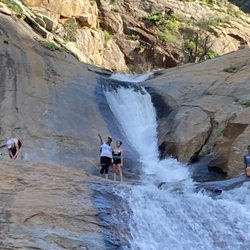
Waterfall in Alpine, California
View Points in Alpine, California
Waterfall Hike in Alpine, California
Photo Spots in Alpine, California
Parks for Kids in Alpine, California
Sunset View in Alpine, California
Running Trails in Alpine, California
Secluded Spots in Alpine, California
Hiking With Kids in Alpine, California
Romantic Views in Alpine, California
Trending Searches in Alpine, CA
Browse Articles
Browse Nearby
Browse Brands
Related Searches in Alpine, CA
Affordable Kayak Rental Services in Alpine, California
Best Fishing Locations and Guides in Alpine, California
Best Nature Trails for Hiking in Alpine, California
Best Places for Horseback Riding in Alpine, California
Best Waterfalls and Swimming Holes in Alpine, California
Check Out Off Road Trails in Alpine, California
Discover Dog Friendly Trails to Explore in Alpine, California
Discover Scenic Hiking Trails in Alpine, California
Discover Scenic Mountain Bike Trails Near Alpine, California
Discover Walking Parks in Alpine, California Near You
Discover a Hiking Trail in Alpine, California
Discover the Best Night Hike Trails in Alpine, California
Dog-Friendly Hikes With Dogs in Alpine, California
Enjoy Camping Adventures Around Alpine, California
Enjoy Exciting Mountain Biking Adventures in Alpine, California
Enjoy Kayaking Adventures in Alpine, California
Enjoy Tent Camping Spots Around Alpine, California
Enjoy a Beautiful Waterfall Hike in Alpine, California
Enjoy a Peaceful Nature Walk in Alpine, California
Enjoy the Best Picnic Spots and Ideas in Alpine, California
Enjoy the Best Walking Path in Alpine, California
Enjoy the Best Walking Trails in Alpine, California
Exciting Cliff Jumping Spots in Alpine, California
Explore Beautiful Parks and Green Spaces in Alpine, California
Explore Easy Hikes Perfect for All in Alpine, California
Explore Fun Activities to Do in Alpine, California
Explore Popular Campgrounds Near Alpine, California
Explore the Best Beach Spots in Alpine, California
Explore the Best Trail Options in Alpine, California
Family Friendly Hiking With Kids in Alpine, California
Find Beautiful Views in Alpine, California
Find Popular Ziplining Spots Around Alpine, California
Find the Best Parks for Picnics in Alpine, California
Find the Best Scenic View Locations in Alpine, California
Great Places to Walk in Alpine, California
Hike the Popular Waterfall Trail in Alpine, California
Hiking Trails With Waterfalls in Alpine, California
Off Leash Dog Hiking Trails in Alpine, California
Popular Outdoor Activities to Try in Alpine, California
Popular Picnic Spots to Visit in Alpine, California
Safe River Swimming Areas in Alpine, California
Safe and Fun Parks for Kids in Alpine, California
Top Climbing Spots and Gyms in Alpine, California
Top Paddleboarding Activities in Alpine, California
Top Places for Snorkeling in Alpine, California
Top Running Trails to Explore in Alpine, California
Top Swimming Lakes to Enjoy in Alpine, California
Top Swimming Spots and Pools in Alpine, California
People who viewed Viejas Mountain also viewed
McGinty Mountain
19 reviews
Historic Flume Trailhead
2 reviews
Blossom Valley
El Cajon Mountain Hiking Trail
140 reviews
Oak Canyon Trail
25 reviews
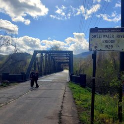
Sweetwater River Bridge
37 reviews
Wright's Field
2 reviews
Lakeside Linkage Preserve
1 review
Shadow mountain Trails
1 review
La Mesa Public Stairs
72 reviews
Lawson Peak Trail
9 reviews