Morena Butte Photos


 hanging off the edge. You can climb on it (if you dare) - Hiking Near Me - Campo, California")

You might also consider
More like Morena Butte
Recommended Reviews - Morena Butte
Start your review...

8 years ago


9 years ago
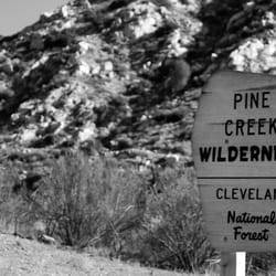
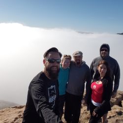
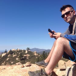
Nestled between Lake Morena to the north and Hauser Canyon to the south is an unassuming mountain called Morena Butte. I get the feeling a lot of people don't know it is even there. It is neither particularly tall, or even distinctive given its surroundings, but it makes for a memorable hike for those willing to put in a few miles to see it and the unique hiking experience it has to offer. The payoff is multi-hued granitic outcroppings, boat loads of exposed boulders and a dizzying cliff-side summit overlooking Hauser Canyon, Barrett Lake and points west and south. The hike starts in Lake Morena County Park. If you GPS it, it will take you right to the park entrance. (If you don't have GPS, take the Buckman Springs Rd exit off of I-8, turn right towards Campo, right on Oak Dr, slight right on Lake Morena Dr to the park. Follow the signs.) You may park in the PTC trail-head lot just outside the county park entrance. No fee or permit is required in this lot- parking inside the park will cost you $3. The southbound PTC trail-head is at the west end of the lot and is marked. Begin the hike there and proceed SW for about 4 miles. The PTC will wind and twist around for a bit, but you will eventually end up westbound coming up from a small creek-bed onto a slight rise before the trail starts its decent into Hauser Canyon. The trail heading up to the butte T's from the right at the top of this rise and at this writing was unmarked. (There was a trail marker at one time, but it was gone this last time I hiked it.) We left a rock cairn to mark the spot. **Important: If you start descending down into Hauser Canyon, you have gone too far. Turn around and go back!** Proceed up the butte trail for about two miles, being careful to follow the numerous cairns marking your way. Vegetation becomes more sparse and rocks more numerous the farther you go so it becomes real easy to get off-trail. If that happens to you, just make sure you continue along the ridge-line in a general westerly direction and keep an eye out for those cairns. You are headed for a summit overlooking Hauser Canyon on the far end of the butte, so keep close to the canyon side of the mountain and keep following the ridge. You will go around to the left of a large rocky rise and will end up on a massive granite outcropping. After gaping at the spectacle for a few minutes, look west-ish and you should see the summit poking up from the far corner of the mountain with a crazy over-hanging rock at its high point. Follow the cairns on the outcropping opposite that, staying generally to the right side of it, then follow the cairns down into a depression at the end of the outcropping. From there you will cut west-ish again and go up a rise where it is real easy to lose the cairns. Most of them are down low and easy to miss in the vegetation. The summit should be ahead of you so just continue and head straight for it. There is nothing wrong with forging your own trail at this point. You will have to rock-scramble the last 100' or so, but finally you will come to the summit. If you go to the far corner of the summit, you are literally standing on the edge of the mountain with a mind bending drop in front of you. If you get up on the highest summit rock it's even better. Enjoy the views of Hauser Canyon and Barrett Lake and have a rest because it is a long way back to the park! read more
More info about Morena Butte
2550 Lake Morena Dr
(PCT Tralhead)
Campo, CA 91906
Directions
(858) 565-3600
Call Now
Hours
Outdoor Amenities
You might also consider


Morena Butte - hiking - Updated July 2026
Best of Campo
People found Morena Butte by searching for…
Things to Do in Campo, California
Hiking Trails in Campo, California
Rock Climbing in Campo, California
Beautiful Views in Campo, California
Photo Spots in Campo, California
Lakes & Ponds in Campo, California
Canyoneering in Campo, California
View Points in Campo, California
Lookout Points in Campo, California
Walking Trails in Campo, California
Off Road Trails in Campo, California
Public Pools in Campo, California
Running Trails in Campo, California
What to Do in Campo, California
Places to Take Pictures in Campo, California
Tent Camping in Campo, California
Trending Searches in Campo, CA
Black Owned Nail Salons near Morena Butte
Dog Friendly Trails near Morena Butte
Lakes & Ponds near Morena Butte
Places To Walk Around near Morena Butte
Public Pools near Morena Butte
Public Shower near Morena Butte
River Swimming near Morena Butte
Running Trails near Morena Butte
Strawberry Picking near Morena Butte
Swimming Holes near Morena Butte
Swimming Lakes near Morena Butte
Browse Articles
Browse Nearby
Browse Brands
Related Searches in Campo, CA
Best Crabbing Locations to Visit in Campo, California
Best Nature Trails for Hiking in Campo, California
Best Places for Horseback Riding in Campo, California
Best Spots for Star Gazing in Campo, California
Best Waterfalls and Swimming Holes in Campo, California
Check Out Off Road Trails in Campo, California
Discover Dog Friendly Beaches Near Campo, California
Discover Dog Friendly Trails to Explore in Campo, California
Discover Popular Bike Trails in Campo, California
Discover Scenic Mountain Bike Trails Near Campo, California
Discover Stunning Skyline View Spots in Campo, California
Discover Top Boat Tours in Campo, California for All Ages
Discover Top Nature Parks to Visit in Campo, California
Discover a Hiking Trail in Campo, California
Discover the Best Night Hike Trails in Campo, California
Dog-Friendly Hikes With Dogs in Campo, California
Effective Stairs Workout Spots in Campo, California
Enjoy Scenic Night View Experiences in Campo, California
Enjoy the Best Picnic Spots and Ideas in Campo, California
Enjoy the Best Walking Trails in Campo, California
Exciting Cliff Jumping Spots in Campo, California
Explore Beautiful Parks and Green Spaces in Campo, California
Explore Free Things to Do Around Campo, California
Explore Popular Campgrounds Near Campo, California
Explore Popular Scenic Overlook Points in Campo, California
Explore Popular View Points Around Campo, California
Explore Scenic Lakes to Visit in Campo, California
Explore the Best Boating Spots in Campo, California
Explore the Best Swimming Holes Around Campo, California
Explore the Best Trail Options in Campo, California
Family Friendly Hiking With Kids in Campo, California
Find Beautiful Views in Campo, California
Find Fun Kids Activities Outdoor in Campo, California
Find Parks and Recreation Activities in Campo, California
Find Top Dog Swimming Spots in Campo, California
Find the Best Parks for Picnics in Campo, California
Find the Best Swimming Pools in Campo, California Today
Hiking Trails With Waterfalls in Campo, California
Off Leash Dog Hiking Trails in Campo, California
Perfect Spots to Watch Sunset in Campo, California
Picnic Areas With BBQ Pits Available in Campo, California
Plan Nature Center Visits in Campo, California
Plan a Scenic Drive Route Near Campo, California
Popular Fishing Spots to Explore in Campo, California
Popular Things to Do in Campo, California
Safe River Swimming Areas in Campo, California
See Top Fireworks Events in Campo, California
Top Running Trails to Explore in Campo, California
People who viewed Morena Butte also viewed
Viejas Mountain
14 reviews
Secret Canyon Trail
6 reviews
Shadow mountain Trails
1 review
Lawson Peak Trail
9 reviews
Lakeside Linkage Preserve
1 review
Wright's Field
2 reviews
Historic Flume Trailhead
2 reviews
Blossom Valley
Rancho San Diego Kiwanis Memorial Trail
2 reviews
Goat Canyon Trestle
34 reviews
Woodhaven County Park
1 review