Harvey Moore Trail Photos


You might also consider
More like Harvey Moore Trail
Recommended Reviews - Harvey Moore Trail
Start your review...

8 months ago
Backpacked to Granite Springs on parts of Harvey Moore loop. Nice trail with wildlife sightings and good primitive group camping. read more


16 years ago
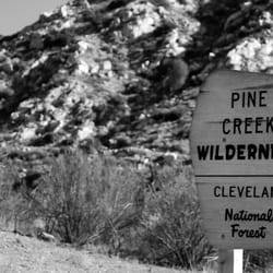
Here is a real nature experience. Coming from San Diego, most of my hike outings have been relatively close to residential and other 'hikers' are plentiful. It's nice and all, but at times feels a bit fake. But Descanso, our neighbor to the not so distant east, finally quenched my Real Nature Thirst. It's definitely a different environment: rolling open fields, erie sleep hollow trees (even one fun to climb and get all sooty! [from its burnt state], ridges with flowing water below, creeks, forest-y parts...it really has it all! oh, including ticks that carry lyme disease, too - FYI. Some fellow hikers gave us the heads up to continuously check your socks and skin. There are some good climbs but mainly it's a distance factor that gives you your work out (roughly 14 miles). For the most part we were left to ourselves and nature, only occasionally running into horseback riders, and a a few hikers - could have been partly due to being Easter Sunday, but something tells me it allows for less foot traffic in general compared to other hiking areas. The funniest aspect of the visit was getting overly excited at spotting wild turkeys. That's how wilderness-starved I have become! This is definitely a great area to explore as a 1/2 day trip. If possible, acquire a map of the grounds before heading out. The trail markers can get confusing and it's easy to question if you are heading the right direction. Even GPS won't save you out here because reception can be lacking. We were lucky to run into 2 rangers on horses to verify getting back to our starting point. Added bonus to coming here: head to the store off the main road for some Dudley's Julian apple pie...ab-so-lut-ely delicious and satisfying end to all the calorie burning you just did! mmm.... Dudleys. read more


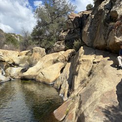
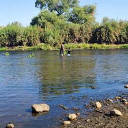
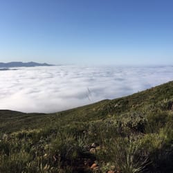
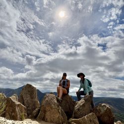
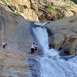
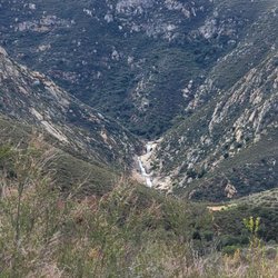
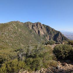
The Harvey Moore Trail is a wonderful day hike adventure! Be prepared for some various terrain and some difficult hiking, or running if you are a little more adventurous. I usually begin at the trail head by the Sweetwater River Bridge on Hwy 79. From this lot (no charge to park here), I usually head south on the trail, which begins with some rather serious ascents. At the top of the first climb you move in some mildly forested areas. Overall the area was damaged tremendously in the 2003 fire storm, and it is wonderful to see the recovery process in full swing with the strong presence of Manzanita, and many Pine and Oak saplings. It is about 5 miles or so to the Trail Camp Site which is a nice refuge on the trail. They sometimes have water in the well even. From here, the hike makes a steep descent down into a creek bed, which actually flows much of the year. The descent trail is not well maintained and slightly overgrown at the moment due to the fires, but it is navicable, so trust yourself and enjoy the climb down. Once at the bottom, the trail meanders next to the stream until it hits the gigantic meadows around the Sweetwater River near the 6th Grade Camp and Park HQ (Cuyamaca Rancho State Park, which the trail is a part of). The entire hike is a loop, which is nice, and measures a good 12 miles or so. The going can be slow in some places, so plan on this taking a while. It is fantastic, and on clear days you can even see Downtown San Diego and Point Loma from the high meadow. Georgeous. Hike here. read more


More info about Harvey Moore Trail
12551 Hwy 79
Cuyamaca Rancho State Park
Descanso, CA 91916
Directions
Hours
Outdoor Amenities
You might also consider


Harvey Moore Trail - hiking - Updated July 2026
Best of Descanso
People found Harvey Moore Trail by searching for…
Campgrounds in Descanso, California
Things to Do in Descanso, California
Hiking Trails in Descanso, California
Camping Sites in Descanso, California
Easy Hikes in Descanso, California
Running Trails in Descanso, California
Off Road Trails in Descanso, California
Playgrounds in Descanso, California
Tent Camping in Descanso, California
Reviews in Descanso, California
Swimming Lakes in Descanso, California
Waterfall Hike in Descanso, California
Waterfalls in Descanso, California
Dog Friendly Hiking Trails in Descanso, California
Camping & Campsites in Descanso, California
Splash Pad in Descanso, California
State Park in Descanso, California
Lookout Points in Descanso, California
Trending Searches in Descanso, CA
4th Of July Fireworks in Descanso, CA
Black Owned Nail Salons in Descanso, CA
Dog Friendly Trails in Descanso, CA
Jet Ski Rental in Descanso, CA
Outdoor Activities in Descanso, CA
Places To Walk Around in Descanso, CA
Running Trails in Descanso, CA
Scenic Night View in Descanso, CA
Scenic Overlook in Descanso, CA
Secluded Spots in Descanso, CA
Strawberry Picking in Descanso, CA
Swimming Holes in Descanso, CA
Swimming Lakes in Descanso, CA
Browse Articles
Browse Nearby
BEST of Descanso, California Restaurants near Harvey Moore Trail
BEST of Descanso, California Coffee near Harvey Moore Trail
BEST of Descanso, California Things to Do near Harvey Moore Trail
BEST of Descanso, California Breakfast near Harvey Moore Trail
BEST of Descanso, California Horseback Riding near Harvey Moore Trail
BEST of Descanso, California Campgrounds near Harvey Moore Trail
Browse Brands
Related Searches in Descanso, CA
Best Fishing Locations and Guides in Descanso, California
Best Places for Horseback Riding in Descanso, California
Best Places for Stunning Views in Descanso, California
Best Waterfalls and Swimming Holes in Descanso, California
Check Out Off Road Trails in Descanso, California
Discover Scenic Hiking Trails in Descanso, California
Discover Scenic Mountain Bike Trails Near Descanso, California
Discover Top Nature Parks to Visit in Descanso, California
Discover Top State Parks to Visit in Descanso, California
Discover Walking Parks in Descanso, California Near You
Discover a Hiking Trail in Descanso, California
Discover the Best Night Hike Trails in Descanso, California
Discover the Best Running Track in Descanso, California
Dog-Friendly Hikes With Dogs in Descanso, California
Effective Stairs Workout Spots in Descanso, California
Enjoy Kayaking Adventures in Descanso, California
Enjoy a Beautiful Waterfall Hike in Descanso, California
Enjoy the Best Picnic Spots and Ideas in Descanso, California
Enjoy the Best Tubing Experiences in Descanso, California
Enjoy the Best Walking Path in Descanso, California
Enjoy the Best Walking Trails in Descanso, California
Exciting Cliff Jumping Spots in Descanso, California
Experience Thrilling White Water Rafting in Descanso, California
Explore Beautiful Parks and Green Spaces in Descanso, California
Explore Easy Hikes Perfect for All in Descanso, California
Explore Popular Campgrounds Near Descanso, California
Explore Popular Scenic Overlook Points in Descanso, California
Explore Scenic Lakes to Visit in Descanso, California
Explore the Best Beach Spots in Descanso, California
Explore the Best Swimming Holes Around Descanso, California
Explore the Best Trail Options in Descanso, California
Family Friendly Hiking With Kids in Descanso, California
Find Beautiful Views in Descanso, California
Find Cozy Camping Cabins in Descanso, California
Find Fun Kids Activities Outdoor in Descanso, California
Find the Best Playgrounds to Visit in Descanso, California
Find the Best Scenic View Locations in Descanso, California
Great Places to Walk in Descanso, California
Hiking Trails With Waterfalls in Descanso, California
Off Leash Dog Hiking Trails in Descanso, California
Plan a Scenic Drive Route Near Descanso, California
Popular Fishing Spots to Explore in Descanso, California
Popular Outdoor Activities to Try in Descanso, California
Popular Things to Do in Descanso, California
Safe River Swimming Areas in Descanso, California
Safe and Fun Parks for Kids in Descanso, California
Top Running Trails to Explore in Descanso, California
Top Swimming Lakes to Enjoy in Descanso, California
People who viewed Harvey Moore Trail also viewed
Silverwood Wildlife Sanctuary
14 reviews
Crestridge Ecological Reserve
6 reviews
Cibbets Flat Campground
7 reviews
Pacific Crest Trail At Penny Pines
22 reviews
Dead Horse Falls Trail
4 reviews
Walker Preserve
26 reviews
Santa Ysabel Preserves
35 reviews
Lake Morena County Park
22 reviews
Santee Boulders
14 reviews
Stonewall Peak
1 review