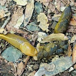
Yolanda Trail Photos


You might also consider
More like Yolanda Trail
Recommended Reviews - Yolanda Trail
Start your review...

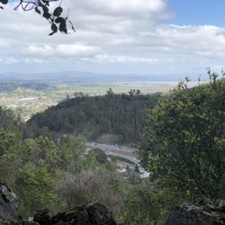
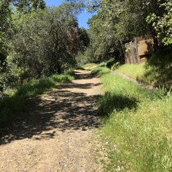
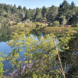
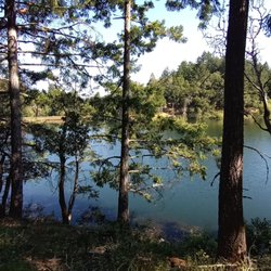
I've always been a fan of the outdoors. But within about the last year or so, I've become a real enthusiast of the outdoors. Over that time, my favored outdoor activity has evolved from hiking to trail running. It's a matter of conditioning. It's not the trails, it's me. I cut weight, got more wind & now love the sensation running through all that beauty & splendor that is Nature. & there's a whole lot of that in Marin. In my ever-expanding quest to run the beautiful Earth, I found Yolanda Trail as a way to reach Phoenix Lake from San Anselmo. The point A was a bit out of necessity. Downtown San Anselmo has charging stations for my EV. The point B was a product of time & morbid curiosity. I hadn't been out to Phoenix Lake in a while & had read online that it was badly depleted due to our historic drought. Might as well go for a run to check it out. Going this route meant taking Oak Ave., a steeply-inclined residential road that eventually led to a gate & private community beyond. At this point, cars are a no-go but hikers, runners & bikers are OK. So long as you don't act like a total A-hole on someone else's street. Oak Ave. ends at Worn Springs Road & then the trail begins right across. Be ready for the Sun & have enough fluids. From this point to Lake Phoenix, there's partial shade in places but there's a lot of exposure to wide open sunshine too. The trail itself is mostly narrow but not technical. I ran it in regular street running shoes (rather than hiking boots or trail running shoes) & did just fine. There are decent inclines/ declines, but nothing too challenging for hiking & moderately challenging for trail running. From Worn Springs Road, the scenery stays interesting by constantly changing from valley vistas to hillside views to spread out tree canopy. Apparently, Yolanda Trail may also be a lesser-known route to Phoenix Lake as I didn't come across many other folks. All the way, out & back, from where I parked the car was almost 8 miles. From Worn Springs Road to Phoenix Lake & back was about 1/2 that. It was a beautiful day. It felt great to be outside. It was a solid workout. Yolanda Trail is a nice addition to my ever-expanding catalog of ways to run the Earth. read more


More info about Yolanda Trail
Worn Springs Rd
Ross, CA 94960
Directions
Hours
Outdoor Amenities
You might also consider


Yolanda Trail - hiking - Updated May 2026
Best of Ross
People found Yolanda Trail by searching for…
Walking Trails in Ross, California
Hiking Trails in Ross, California
Running Trails in Ross, California
Beautiful Views in Ross, California
Things to Do in Ross, California
Shaded Hike in Ross, California
Walking Groups in Ross, California
Lakes & Ponds in Ross, California
View Points in Ross, California
Lookout Points in Ross, California
Easy Hikes in Ross, California
Off Leash Dog Hikes in Ross, California
Off Road Trails in Ross, California
Bike Paths in Ross, California
Scenic Views in Ross, California
Watch Sunset in Ross, California
Dog Friendly Hiking Trails in Ross, California
Trending Searches in Ross, CA
Botanical Gardens near Yolanda Trail
Bounce House Rentals near Yolanda Trail
Campgrounds near Yolanda Trail
Cherry Picking near Yolanda Trail
Cliff Jumping near Yolanda Trail
Floral Designers near Yolanda Trail
Flower Fields near Yolanda Trail
Flower Shop near Yolanda Trail
Garage Sales near Yolanda Trail
Garden Center near Yolanda Trail
Golf Lessons near Yolanda Trail
Lakes & Ponds near Yolanda Trail
Nurseries & Gardening near Yolanda Trail
Outdoor Activities near Yolanda Trail
Outdoor Furniture Stores near Yolanda Trail
Party Equipment Rentals near Yolanda Trail
Photo Spots near Yolanda Trail
Picnic Areas near Yolanda Trail
Places To Take Pictures near Yolanda Trail
Plant Nursery near Yolanda Trail
Rock Quarry near Yolanda Trail
Running Trails near Yolanda Trail
Scenic Drive near Yolanda Trail
Scenic Night View near Yolanda Trail
Sunrise View near Yolanda Trail
Swimming Holes near Yolanda Trail
Browse Articles
Browse Nearby
BEST of Ross, California Restaurants near Yolanda Trail
BEST of Ross, California Coffee near Yolanda Trail
BEST of Ross, California Things to Do near Yolanda Trail
BEST of Ross, California Parks near Yolanda Trail
BEST of Ross, California Breakfast near Yolanda Trail
BEST of Ross, California Lakes near Yolanda Trail
Browse Brands
Related Searches in Ross, CA
Best Fishing Locations and Guides in Ross, California
Best Nature Trails for Hiking in Ross, California
Best Places for Horseback Riding in Ross, California
Best Waterfalls and Swimming Holes in Ross, California
Check Out Off Road Trails in Ross, California
Discover Dog Friendly Trails to Explore in Ross, California
Discover Kid Friendly Hiking Trails in Ross, California
Discover Scenic Hiking Trails in Ross, California
Discover Scenic Mountain Bike Trails Near Ross, California
Discover Scenic Waterfall Spots in Ross, California
Discover Top Nature Parks to Visit in Ross, California
Discover a Hiking Trail in Ross, California
Discover the Best Night Hike Trails in Ross, California
Discover the Breathtaking Waterfall Trail in Ross, California, {State}
Dog-Friendly Hikes With Dogs in Ross, California
Enjoy Camping Adventures Around Ross, California
Enjoy Exciting Mountain Biking Adventures in Ross, California
Enjoy Kayaking Adventures in Ross, California
Enjoy Tent Camping Spots Around Ross, California
Enjoy a Beautiful Waterfall Hike in Ross, California
Enjoy the Best Picnic Spots and Ideas in Ross, California
Enjoy the Best Walking Trails in Ross, California
Exciting Cliff Jumping Spots in Ross, California
Explore Beautiful Parks and Green Spaces in Ross, California
Explore Easy Hikes Perfect for All in Ross, California
Explore Fun Activities to Do in Ross, California
Explore Popular Campgrounds Near Ross, California
Explore the Best Beach Spots in Ross, California
Explore the Best Swimming Holes Around Ross, California
Explore the Best Trail Options in Ross, California
Find Beautiful Views in Ross, California
Find Popular Ziplining Spots Around Ross, California
Find the Best Parks for Picnics in Ross, California
Find the Best Scenic View Locations in Ross, California
Hiking Trails With Waterfalls in Ross, California
Off Leash Dog Hiking Trails in Ross, California
Plan a Scenic Drive Route Near Ross, California
Popular Outdoor Activities to Try in Ross, California
Popular Picnic Spots to Visit in Ross, California
Safe River Swimming Areas in Ross, California
Safe and Fun Parks for Kids in Ross, California
Top Climbing Spots and Gyms in Ross, California
Top Paddleboarding Activities in Ross, California
Top Places for Snorkeling in Ross, California
Top Playgrounds for Kids to Enjoy in Ross, California
Top Running Trails to Explore in Ross, California
Top Swimming Lakes to Enjoy in Ross, California
Top Swimming Spots and Pools in Ross, California
People who viewed Yolanda Trail also viewed
Terra Linda Sleepy Hollow Ridge
14 reviews
Baltimore Canyon
18 reviews
Terra Linda-Sleepy Hollow Divide Northern Preserve
10 reviews
Mt. Tamalpais Watershed/Phoenix Lake Trailhead
8 reviews
San Pedro Ridge
5 reviews
Shoreline Industrial Park
8 reviews
Natalie Coffin Greene Park
12 reviews
Hamilton Field Bay Trail
14 reviews
Miwok Park
13 reviews
Dolliver Park
13 reviews