Sky Trail Photos


More like Sky Trail
Recommended Reviews - Sky Trail
Start your review...

10 months ago
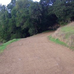
Sky trail is a peaceful escape from the crowds at Point Reyes. While you can access it via several trails that climb up from Bear Valley, the actual trailhead is along the road Limantour Road, about 3.5 mile mark. There's a small dirt lot on the left hand side. On Labor Day, the lot wasn't full and the trail itself was very peaceful. I followed Sky Trail towards Sky camp but turned off prior to the camp on to Horse Trail, then Z Ranch to the Mt Wittenberg spur. On the return trip turned right on the Mt Wittenberg trail which loops back to Sky and takes through the rest of the loop past Sky Camp and back down to the trailhead. Mt Wittenberg is the highest point in Pt Reyes but don't expect sweeping or epic views. It's a quiet woodland trail where you can get some peeks out at the bay. Taking Sky Trail here involved less elevation gain than if you climbed up from the trails near Bear Valley. NPS has a good description of the trail here: https://www.nps.gov/thingstodo/hike-to-mount-wittenberg-from-sky-trailhead.htm The hike along Sky Trail is about the journey as it meanders through lush forest and occasionally offers some ocean or bay views. It was impacted by the 2020 Woodward fire and a few sections lack shade due to the canopy burning but overall, the forest seems to be recovering nicely. I enjoy this trail for the quiet and to be in the forest. Late summer, there were a few wildflowers and things have stayed amazingly green. Although my loop was shy of 5 miles, Sky trail connects with many others. The visitor center at Bear Valley offers decent maps and guidance from rangers if you're looking for any other ideas. Point Reyes has so many options for hikes and lesser known park trails-after 12 years of visiting, I'm still finding new adventures to enjoy. Sky Trail will now be a regular for me. read more


When it comes to local hiking trails, there are three elements that will steal my heart away just about every single time; a heavily wooded forest, lush green foliage, and beautiful coastal views. The Sky Trail has all of this. So naturally, I fell in love with this trail right off the bat. The Sky Trail is a lightly trafficked hiking trail that runs through Point Reyes National Seashore. You can connect to this trail from a few different trails within the park. I started my hike from the parking lot near the Bear Valley trailhead and made a right onto the Mount Wittenberg trail. From here, it's about 2 miles until you reach the Sky Trail. The hike from Mount Wittenberg to the Sky Trail is pretty intense, and starts off immediately inclining through the forest. It's mostly uphill until you reach the Mount Wittenberg summit. Once you've made it to the summit, you'll see a few trailhead signs and a trail split. From here you'll continue on the Mount Wittenberg trail for about a half mile until you reach the Sky Trail. You'll start to decline as you get closer to the trail. And my oh my is this trail gorgeous! This section of the Sky Trail is surrounded by a plethora of tall trees. As you continue down the path, you'll start to notice a break in the trees and the stunning views of the coastline will hit you like a ton of bricks. There are also sections of the trail that are plant heavy and vibrantly green. Once you pass this, you'll end up descending down a steep and narrow pathway until you reach the Coast Trail. It's about a 3 mile trek until you reach the connecting trail, and about another mile or less if you want to get down to Kelham beach. So, roughly 6 miles from the parking lot to the beach via the Sky Trail (and that's one way). Going down the Sky Trail can be tough because it's super steep on the way down, but coming up is a real challenge. If you want to skip the treacherous hike all the way back up the hill, you can take the Coast Trail back to Bear Valley, and this will loop you back to the parking lot. It's also a more scenic trek along the coastline, and you'll get to walk amongst pretty Redwoods and a beautiful stream along the Bear Valley trail on the way back. Point Reyes has so many incredible hiking trails, but because the Sky Trail requires some additional trekking to get to, it's far less traveled. Would highly recommend the Sky Trail for people who are looking for a challenging hike without much foot traffic. read more


More info about Sky Trail
Lagunitas, CA 94938
Directions
Hours
Outdoor Amenities


Sky Trail - hiking - Updated June 2026
Best of Lagunitas
People found Sky Trail by searching for…
Hiking Trails With Waterfalls in Lagunitas, California
Beaches in Lagunitas, California
Mountain Biking in Lagunitas, California
Things to Do in Lagunitas, California
Beautiful Views in Lagunitas, California
Campgrounds in Lagunitas, California
Fun Things to Do at Night in Lagunitas, California
Scenic Night View in Lagunitas, California
Parks in Lagunitas, California
Easy Hikes in Lagunitas, California
Redwood Trees in Lagunitas, California
Waterfall in Lagunitas, California
Swimming Lakes in Lagunitas, California
Night Hike in Lagunitas, California
Running Trails in Lagunitas, California
Visitor Centers in Lagunitas, California
Off Road Trails in Lagunitas, California
Views in Lagunitas, California
Trails in Lagunitas, California
Romantic Spots in Lagunitas, California
Camping Sites in Lagunitas, California
Waterfalls and Swimming Holes in Lagunitas, California
Browse Nearby
BEST of Lagunitas, California Restaurants near Sky Trail
BEST of Lagunitas, California Parks near Sky Trail
BEST of Lagunitas, California Things to Do near Sky Trail
BEST of Lagunitas, California Coffee near Sky Trail
BEST of Lagunitas, California Breakfast near Sky Trail
BEST of Lagunitas, California Swimming Holes near Sky Trail