Cataract Falls Trail Photos


You might also consider
More like Cataract Falls Trail
Recommended Reviews - Cataract Falls Trail
Start your review...

Reviews With Photos

One of the toughest but rewarding hikes. The drive there was very windy. Take it slow!Parking is very limited and was somewhat scary for me with the narrow roads. The hike starts out flat for maybe the first .10 mile(?). Then it's all uphill. But the beautiful views of the lake and the various waterfalls definitely made it all worth it. Plus there are stairs that help you with the climb! We didn't make it all the way to the end but probably turned around at a mile in. But the experience was great. Don't forget to wear good hiking boots and lots of bug spray!

This hike is beautiful! Be prepared for a steep hike, but totally worth it. I would say if you have any trouble with steep hikes to bring a walking stick. We did about 2 1/2 miles round-trip and I believe you can go much further. The water surrounding the trail is a stunning site. There is no swimming/plunging. I was pretty disappointed to see that people had left trash behind. The area seemed very secluded for there to be so much trash, it was upsetting. Whatever you bring in bring out! Do not leave your trash! Do not litter! Other than that, bring plenty of water and enjoy the wonderful waterfalls!

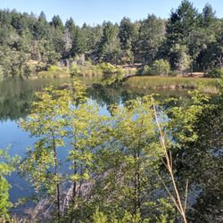
Tough climb but super serene and refreshing. Trail is in the Mt. Tamalpais Watershed but starts at a much lower elevation than the hikes near Bon Tempe Lake. Here you start low and end up high, then back down. There's a beautiful lake (a piece of Alpine Lake)at the base surrounded by trees and reflects the sky effortlessly. Once on this trail it only does one thing...it climbs and climbs and climbs. No meandering trails that weave through a hilllside in a gradual fashion. Here it is pretty much in a straight fashion, many are steps whether wooden or stone. A few other trails intersect here so one can extend a hike to different areas. Gotta be savvy with maps for that. A little over a mile up. About 1000 feet of elevation gain. I can usually hike a flat-ish mile in a half hour. Here it took me over an hour. I had to take several breaks as some stretches were pretty draining. But after the first stop or 2 I just used those breaks to really breathe in the clean air and absorb the tranquil surroundings. Lots of pools of water, basically a stream going down this hillside so lots of trickling sounds and even a few spots of rushing waterfalls. The flow of water is probably more vigorous in the spring after a seasons worth of fresh rain. Late summer it was quite mellow but relaxing. At the top is just a flat meadow next to the rocky stream. There's a couple of picnic benches up there. At first I was a bit underwhelmed as usually after a good climb there's usually a rewarding view overlooking something. Here not so much as you're still in the middle of a forest. But as I refreshed myself near the stream I just watched these blue jays glide from the trees to the stream. And monarch butterflies fluttered in patches of sunlight to bask in the heat. And an occasional breeze would shake down small dried leaves like a gentle snowfall, as the tranquil silence enveloped me like a long lost embrace. All the strenuous efforts of the climb, all of a sudden felt mute, justified...satisfied...amazed.

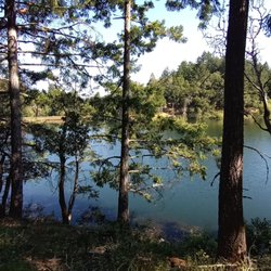
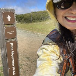
Mountain Tam's Cataract Falls trail is my favorite hiking trail in Marin. The trail follows Cataract Creek as it cascades down Mount Tamalpais and flows into Alpine Lake. About 4 mile out-and-back trail near Stinson Beach, California. Cataract Falls Trail is considered a challenging route, it takes an average of 3 hours, including the time to stop for lunch. At the start of the trail, I feel like it's the cardiac trail, as the steps will take you straight up with the elevation gain of 1300 ft! The steepest part of the trail is treacherous uphill at the beginning. Don't worry as the beautiful scenery and the waterfalls will ease your elevation gain. It's a serious hike! Beautiful hike with an incredible views. Totally worth the climb for sure. Enjoy!


Met up with friends at end of May for a day hike. Started at Rock Spring parking lot, potty available. Total 6 miles, first 1.5 miles is easy flat with spars people on the trail. After Laurel Dell picnic area, it is a constant descend with lots of waterfalls and pools. Entire trail was pleasantly shaded in the forest. My one con was lots of people which is not convenient for the single track trail

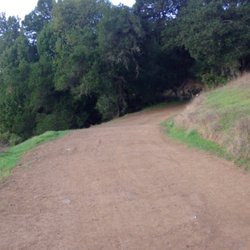
There are many waterfalls in Marin, but I feel this is the most impressive one. The hike encompasses numerous large waterfalls instead of just one along the trail. The best time to go is after a heavy rain when the water is gushing. Parking is very hard on Bolinas Road, it's best to come early. There is also an entrance on Mt. Tam, but it adds about an extra mile to the hike. The hike isn't that long but it does take a while because it's uphill all the way and there is a lot of stopping for photos. It can get crowded on weekends after a heavy rain. It's not a hard hike but it kinda creeps up on you and something to think about if you have bad knees for the descent. It's very shaded the whole way with tons of greenery, ferns and moss, You feel like you are in a fairytale forest.

Cataract Falls is one of those quintessential, must do Bay Area hikes. But because of that, the trail has become even more popular and difficult to navigate over the years. I usually go once a year and have found that parking at the Rock Spring lot, following the creek and going downhill allows for easier parking, a peaceful hike through the woods in the first portion but an uphill return trip. Winter is the time to go after a good, steady rain but that does make the trail slippery. I find that hiking poles are a must for this hike. I came twice, recently. On 12/26/23, I parked at Rock Spring, arriving around 9:30 and had the falls nearly to myself. The woods were mossy green and mushrooms were sprouting up everywhere. It had rained but the not a lot, so the falls were flowing-but not too strongly. Still, it was a wonderful, peaceful hike. Yesterday, 01/15/2024, I came back and took a friend, who's never been and parked at the bottom, near Alpine Dam. It was a later arrival than I hoped on a holiday Monday, but before 11 and parking was available along the road (there's only a few spaces and then some sketchy roadside parking.) Our way up was lovely-not too many other hikers and after some heavier rain, the falls were wonderful-everything so lush and green! My only complaint is not so much the influx of people, the later it got on trail-it's good to see people get outside and enjoy nature. What made the hike less pleasant as more people arrived, is the general lack of trail etiquette and unprepared hikers. People just barreling down narrow, steep trails and not being aware of trails users trying to keep their footing was a big issue. There were others who were going off trail and it was surprising (but maybe not) to see some trail goers wearing white tennis shoes or other footwear with no traction. They were slipping past other hikers, causing unsafe passing conditions. So, if you go, stick to weekdays and non-holidays if you want more solitude, come prepared for slippery muddy conditions, be respectful of those around you and nature, itself. This is a beautiful, special trail in the winter months and worth the windy drive up in to the Mt Tam watershed.


By far the most magical hike I've ever taken. We went in February and the water was gushing! I've never seen such a long trail of water falls from top to bottom...the 1.5 hike is no joke. It's slippery and super steep but well worth it!!! It took us three hours round trip. Also be aware that parking is very limited. Still worth it though!

Long trail. Used the all trail app to do a 12-13 mile loop. Cataract falls came first Then alpine lake Then the major lake Alpine Lake and Table Rock via Willow Camp and Matt Davis Loop on AllTrails https://www.alltrails.com/trail/us/california/alpine-lake-and-table-rock-via-willow-camp-and-matt-davis-loop?sh=uyvtjx

It was a steep climb with many many stairs but we definitely saw some very cool views. It's very shady and lots of green. I recommend you wear good hiking shoes cause I fell on my way to the water. We got a great workout out of it. The only problem is parking. We had to walk like 6 minutes down to the trail cause it was very busy. Also, we expected a better view at the top of the trail, not just some picnic tables, which was a little disappointing. But overall it's a great hike!


I had forgotten just how gorgeous this hike is--the scenery is incredible the entire way. Be prepared for a steady climb through most of the route, with plenty of wooden stairs, gnarly roots, and rock steps, but the stunning views make every bit of effort worth it. There are many great spots to stop for photos, take a break, or enjoy a picnic--we did all three. Thanks to the recent rain, there was still plenty of water flowing, which made the trail even more beautiful. The picnic area at Laurel Dell is especially serene, with a babbling brook nearby. There's even an outhouse, which is always a welcome sight. I actually found climbing up much easier than descending as one has to really pay attention to their footing. We were happy seeing Alpine Lake again knowing we were close to end of hike. read more


2 months ago
Went here with a friend and her dog and had such a great time. Such a beautiful, peaceful hike and definitely one of my favorites on Mount Tam. The drive in was beautiful too, the views of Alpine Lake along the way made the whole trip feel extra special before we even got to the trail. Be prepared for a lot of stairs, so it can definitely get your legs working, but the waterfalls make it completely worth it. Hearing the water and being surrounded by all the greenery made the whole hike feel so calm and relaxing. The views throughout the hike are gorgeous, and it's such a nice escape if you're looking for something peaceful and scenic. Definitely recommend checking out Cataract Falls if you're up for a little workout with a really rewarding payoff. Definitely will be coming back :) read more


3/21/2026, on our quest of visiting as many Water Falls as we can while we're still in CA, we drove to see the Cataract Falls Trail in Fairfax (Bolinas) from the East Bay. Took the 880-80-580-San Raphael Bridge to Fairfax and follow the Apple Map to the trail. We had to park on the street quite away from the trail, but it's a hiking day so it's OK. From the bottom to the Falls is about 1 mile up hill a little but we stopped there and not going up higher. There's a lake on the way to the falls on the left which is very nice. The trail is narrow sometimes. It was a nice experience and the Cataract Falls actually has water running down. We're very happy. This one is close to the Cascade Falls which we went last year and saw dried up falls, no water, so we will try it on the way back. https://youtu.be/b-TLp1fuw1g read more


One of the toughest but rewarding hikes. The drive there was very windy. Take it slow!Parking is very limited and was somewhat scary for me with the narrow roads. The hike starts out flat for maybe the first .10 mile(?). Then it's all uphill. But the beautiful views of the lake and the various waterfalls definitely made it all worth it. Plus there are stairs that help you with the climb! We didn't make it all the way to the end but probably turned around at a mile in. But the experience was great. Don't forget to wear good hiking boots and lots of bug spray! read more


This hike is beautiful! Be prepared for a steep hike, but totally worth it. I would say if you have any trouble with steep hikes to bring a walking stick. We did about 2 1/2 miles round-trip and I believe you can go much further. The water surrounding the trail is a stunning site. There is no swimming/plunging. I was pretty disappointed to see that people had left trash behind. The area seemed very secluded for there to be so much trash, it was upsetting. Whatever you bring in bring out! Do not leave your trash! Do not litter! Other than that, bring plenty of water and enjoy the wonderful waterfalls! read more


10 months ago
Tough climb but super serene and refreshing. Trail is in the Mt. Tamalpais Watershed but starts at a much lower elevation than the hikes near Bon Tempe Lake. Here you start low and end up high, then back down. There's a beautiful lake (a piece of Alpine Lake)at the base surrounded by trees and reflects the sky effortlessly. Once on this trail it only does one thing...it climbs and climbs and climbs. No meandering trails that weave through a hilllside in a gradual fashion. Here it is pretty much in a straight fashion, many are steps whether wooden or stone. A few other trails intersect here so one can extend a hike to different areas. Gotta be savvy with maps for that. A little over a mile up. About 1000 feet of elevation gain. I can usually hike a flat-ish mile in a half hour. Here it took me over an hour. I had to take several breaks as some stretches were pretty draining. But after the first stop or 2 I just used those breaks to really breathe in the clean air and absorb the tranquil surroundings. Lots of pools of water, basically a stream going down this hillside so lots of trickling sounds and even a few spots of rushing waterfalls. The flow of water is probably more vigorous in the spring after a seasons worth of fresh rain. Late summer it was quite mellow but relaxing. At the top is just a flat meadow next to the rocky stream. There's a couple of picnic benches up there. At first I was a bit underwhelmed as usually after a good climb there's usually a rewarding view overlooking something. Here not so much as you're still in the middle of a forest. But as I refreshed myself near the stream I just watched these blue jays glide from the trees to the stream. And monarch butterflies fluttered in patches of sunlight to bask in the heat. And an occasional breeze would shake down small dried leaves like a gentle snowfall, as the tranquil silence enveloped me like a long lost embrace. All the strenuous efforts of the climb, all of a sudden felt mute, justified...satisfied...amazed. read more


 - Hiking Near Me")
 - Hiking Near Me")
2 years ago
Mountain Tam's Cataract Falls trail is my favorite hiking trail in Marin. The trail follows Cataract Creek as it cascades down Mount Tamalpais and flows into Alpine Lake. About 4 mile out-and-back trail near Stinson Beach, California. Cataract Falls Trail is considered a challenging route, it takes an average of 3 hours, including the time to stop for lunch. At the start of the trail, I feel like it's the cardiac trail, as the steps will take you straight up with the elevation gain of 1300 ft! The steepest part of the trail is treacherous uphill at the beginning. Don't worry as the beautiful scenery and the waterfalls will ease your elevation gain. It's a serious hike! Beautiful hike with an incredible views. Totally worth the climb for sure. Enjoy! read more


11 months ago
My go-to spot to hike with my boys. So many waterfalls and cute spots to picnic. They love dipping their feet in the water near one of the falls. We've spotted lots of creatures along the way including deer, banana slugs, and chipmunks. read more

Met up with friends at end of May for a day hike. Started at Rock Spring parking lot, potty available. Total 6 miles, first 1.5 miles is easy flat with spars people on the trail. After Laurel Dell picnic area, it is a constant descend with lots of waterfalls and pools. Entire trail was pleasantly shaded in the forest. My one con was lots of people which is not convenient for the single track trail read more


There are many waterfalls in Marin, but I feel this is the most impressive one. The hike encompasses numerous large waterfalls instead of just one along the trail. The best time to go is after a heavy rain when the water is gushing. Parking is very hard on Bolinas Road, it's best to come early. There is also an entrance on Mt. Tam, but it adds about an extra mile to the hike. The hike isn't that long but it does take a while because it's uphill all the way and there is a lot of stopping for photos. It can get crowded on weekends after a heavy rain. It's not a hard hike but it kinda creeps up on you and something to think about if you have bad knees for the descent. It's very shaded the whole way with tons of greenery, ferns and moss, You feel like you are in a fairytale forest. read more


2 years ago
Cataract Falls is one of those quintessential, must do Bay Area hikes. But because of that, the trail has become even more popular and difficult to navigate over the years. I usually go once a year and have found that parking at the Rock Spring lot, following the creek and going downhill allows for easier parking, a peaceful hike through the woods in the first portion but an uphill return trip. Winter is the time to go after a good, steady rain but that does make the trail slippery. I find that hiking poles are a must for this hike. I came twice, recently. On 12/26/23, I parked at Rock Spring, arriving around 9:30 and had the falls nearly to myself. The woods were mossy green and mushrooms were sprouting up everywhere. It had rained but the not a lot, so the falls were flowing-but not too strongly. Still, it was a wonderful, peaceful hike. Yesterday, 01/15/2024, I came back and took a friend, who's never been and parked at the bottom, near Alpine Dam. It was a later arrival than I hoped on a holiday Monday, but before 11 and parking was available along the road (there's only a few spaces and then some sketchy roadside parking.) Our way up was lovely-not too many other hikers and after some heavier rain, the falls were wonderful-everything so lush and green! My only complaint is not so much the influx of people, the later it got on trail-it's good to see people get outside and enjoy nature. What made the hike less pleasant as more people arrived, is the general lack of trail etiquette and unprepared hikers. People just barreling down narrow, steep trails and not being aware of trails users trying to keep their footing was a big issue. There were others who were going off trail and it was surprising (but maybe not) to see some trail goers wearing white tennis shoes or other footwear with no traction. They were slipping past other hikers, causing unsafe passing conditions. So, if you go, stick to weekdays and non-holidays if you want more solitude, come prepared for slippery muddy conditions, be respectful of those around you and nature, itself. This is a beautiful, special trail in the winter months and worth the windy drive up in to the Mt Tam watershed. read more


The Cataract Falls Trail is beautiful but watch your steps. It's incredibly slippery muddy and steep in some areas. There's also a fallen trunk that you'd have to duck under. A stair master hike in the nature. There's only one bench the whole hike. read more


By far the most magical hike I've ever taken. We went in February and the water was gushing! I've never seen such a long trail of water falls from top to bottom...the 1.5 hike is no joke. It's slippery and super steep but well worth it!!! It took us three hours round trip. Also be aware that parking is very limited. Still worth it though! read more

Long trail. Used the all trail app to do a 12-13 mile loop. Cataract falls came first Then alpine lake Then the major lake Alpine Lake and Table Rock via Willow Camp and Matt Davis Loop on AllTrails https://www.alltrails.com/trail/us/california/alpine-lake-and-table-rock-via-willow-camp-and-matt-davis-loop?sh=uyvtjx read more


4 years ago
It was a steep climb with many many stairs but we definitely saw some very cool views. It's very shady and lots of green. I recommend you wear good hiking shoes cause I fell on my way to the water. We got a great workout out of it. The only problem is parking. We had to walk like 6 minutes down to the trail cause it was very busy. Also, we expected a better view at the top of the trail, not just some picnic tables, which was a little disappointing. But overall it's a great hike! read more


2 years ago
Super pretty waterfalls and trees. Well maintained path and clear steps pretty difficult hike though it was rough but worth it! read more


Falls: Went in beginning of Oct 2021 so most of the falls were dry or tiny dribbles, but the hike was great. Shade: It was almost completely shady which was great. Difficulty: I am a pretty fit person who does high intensity training 4-5 times a week and read many people said this hike was 'easy' and had a lot of stairs. I could do it just fine but would not call it easy for anyone. There are A LOT of steep stairs and some rugged rock areas. For some people it could be very hard, just FYI. read more

Loved this hike! The only reason for 4 stars is because parking was a pain in the butt. There was probably better parking on the opposite end of the trail but to be honest, I was glad we hiked up the first half and down the second. On that note, there were a lot of stairs but it made the hike actually feel like exercise. All of the shade kept the temperature perfect and the waterfalls made for nice little moments of nature appreciation. It was pretty busy (it was the weekend) but everyone was respectful of the foot traffic going both ways. Highly recommend checking this trail out. read more


So lush, so green, waterfalls everywhere. Even if you have cataracts you would still be able to appreciate this hike. We hiked to the picnic tables which was approximately 4 miles RT. There are some stairs and uphill incline so I would rate it moderate but it's certainly a trail that is doable for the whole family. I quickly learned there were multiple waterfalls throughout the entire hike. It's nice that you don't have to go too far into the hike to already start seeing them though. Of note we did come after rain so I'm not sure what the falls would be like otherwise. I think it would still a very beautiful hike though even if the falls weren't flowing. I would say the only minor less appealing aspects of the hike were the road to get here is a little narrow and windy. Parking is just along the side of the road, also narrow. read more


2 years ago
Absolutely stunning! I came alone on a Friday morning (11am) and had no issues with parking near the trail entrance. I highly recommend wearing shoes with grip to prevent from slipping and falling/injury. This is natures stairmaster. Make sure to hydrate prior to starting. There is a porta potty onsite. read more


Ok so this is what I'll say... The views are beautiful here. This is not an easy trail .. I'm not a professional hooker so take what I say with a grain of salt but I wouldn't say this was way. And parts of it were very narrow and in some cases it was slippery. I didn't make it all the way up to the top. Not sure what the top looks like but for me to get to where I made it and still be able to capture as many beautiful shots as I did, I can only imagine what it looks like at the top. One of the things I want to be sure to bring up is that driving up the the trail was quite scary as well. We are driving up a mountain with lots of twists, turns and narrow roads. There were lots of bikers we had to try and creep around and it was one lane each way and in some cases, one lane period. I don't usually get nauseous going up mountains but I was a little queasy getting to this trail but it was worth it for the views. read more


5 years ago
We did the 9mile loop of this hike and it was so beautiful! I like that you can decided how much of the hike you want to do. There were nice picnic tables further past the falls with bathrooms but beware that the portopotties are horrific. I ended up holding it until I got to a restaurant. The trail itself is really beautiful and has different terrain. Only complaint is that it gets crowded at the beginning of the hike because that's where all the falls are. But if you keep going, we were able to have the trail to ourselves for a large portion of it. I would come back again and swim in the falls! read more

Went in August, very little water and a billion steps. Definitely don't recommend if you are expecting a mellow nature hike and recommend earlier in the season. Minimal parking. Otherwise, beautiful to be in the greenery and fresh air. read more


One of the best hikes I've been to but a hard trail! I love living here in the SF Bay Area!! So many beautiful places to see nature at its best!! I also like adventure and waterfalls! I'm an outdoorsy kinda person when I exercise. This trail offers lots to see from rock trails, shade, to tons and tons of steps like a stair master but worse, lots of green foliage, fallen trees, red woods and waterfalls! I would totally recommend to start the trail from Bolinas Fairfax Road to go up the Cataract trail then down to make it easier on your legs. We did the opposite by starting at the Ridgecrest Blvd/Pan Toll Rd and it was super tiring especially going up the stairs for our last part of the hike. We did a lot of detours going down the multiple waterfalls so we ended up almost seven miles vs five miles. I was perfectly fine doing the trail but the siblings I went with, were struggling a bit as they are not used to it. This is not really for beginners but if you have the will to finish, it's doable still. I totally recommend this place but come early to find parking. There is a lot of bikers on the road getting here so watch out for them as you have to share the small road with them. Very picture worthy!! [83/100] read more


4 years ago
A moderate hike. The good thing is that the trail is for the mostly shaded. It wasn't one of my favorite hikes but it was a good amount of miles. read more


Beautiful hiking trail in Mt. Tam. It has lots of good breathtaking views. This trail tho has a lot and lots of stairs so be prepared for it. You will see lots of running water, the lake, mini falls and the Cataract falls itself. Enjoy the view as you hike along. Bring some water, some snacks and good shoes as this trail may be hard if your not wearing a good shoe for hiking. read more

Cataract Falls is a quick out and back trail that serves up beautiful scenery, waterfalls, and with over 1,000 feet elevation gain a moderate workout. We picked this trail based on recommendations from locals and because it was close to several creameries in the area that we wanted to explore. We went in December and it had rained for several days leading up to our hike. I know it's not always possible to go after rainfall, but this is the best time to visit because the plants were lush and green and the falls were active and flowing. The trail is well marked and popular and we saw people of all ages and capabilities making the 3.3 mile trek. It's not overly strenuous, although there is a steady incline for the first mile and a half. There is plenty of shade and lots of places to stop and experience the tranquility of the falls and forest. We enjoyed the hike and if you can, visit a few days after rainfall or in the winter/spring. read more


3 years ago
3 years ago
Marin county has tons of hiking spots, and Mt. Tamalpais is known for it. Super cute trail and easy to hike, even if you have kids too. Came by here this past weekend and it was so beautiful! It was still low key raining a bit but a little water doesn't hurt. Started on the dam side, and bundled up. Trail can be tricky when wet. Waterfalls everywhere though The sound of rain, waterfall and just pure silence was bliss. I was very alone pretty much my entire hike, and passed by a couple of people. Everyone was social distancing and wearing masks. Great butt workout up those steps! read more


2 years ago
Cataract Falls in Bolinas, CA was so beautiful and easy to hike. It is a family friendly hike as it is a short in and out route. There was free parking nearby but it was very busy when I went. Luckily everyone was wearing a mask and trying to social distance as much as possible. I highly recommend this hike. If you have any questions reach out. read more


6 years ago
2 years ago
8 years ago
More like 3.5 stars This hike is definitely not for beginners, and driving there takes forever. Lots of Lance Armstrong wannabes on your way there and back, so expect to see them along the way and share the road. Get here super early, there's no actual parking lot. Everyone is parked on the side of the road, and it's difficult to make U-turns. I recommend coming after a full week of rain, as we came when there was a semi-drought and no water rushing through; therefore, no big falls to see. Of all the years exploring SF to Marin, I never thought of coming 'til after having kids. They're the ones who keep me constantly moving. They did leave me in the dust, even the dog. I stopped mid-way when they said I was whining too much, so I started a picnic near one of the many falls. I will probably not come back again LOL! 'Til next time or maybe never ~ happy trails and see you on Yelp (SYOY)! read more


 - Hiking Near Me")


 - Hiking Near Me")


Somewhere along the way between a case of plantar fasciitis & just life, I got away from being often outdoors hiking & trail running the great many incredible trails all around the Bay Area. So, to get back on track, & do it with an exclamation point, I decided to finally go to a place I've had bookmarked for years: Cataract Falls. Getting to the Cataract trailhead was a long windy drive on Fairfax-Bolinas Road fraught with bicyclists who don't seem to care enough about not getting run over & deer that occasionally lope across the road. The key to not hitting anyone or anything on 2 wheels or 4 legs is to go slow. Arriving without a new hood ornament, I scored choice parking. Beautiful everywhere. Really, those 2 words could've been the entire review. From the trailhead to Laurel Dell picnic area, it's moderately steep & moderately rugged. With water flowing & cascading right next to the trail pretty much the whole way. I ran in spots, hiked in spots, & stopped a bunch of times to snap pictures. It was close to 3 miles out & back. By the time I got back to the car, I'd worked up enough sweat & endorphins, deeply filled up my lungs with enough crisp fresh air, that I wondered how I'd gotten away from this so long. There's so much astonishing natural beauty out in the wilds around the Bay Area. Cataract Falls is 1 such place. I will be getting back out there. & I will be getting back here. read more


2 years ago
I have recently visited this location with a few colleagues of mine. This unique experience offers a variety of vast and wonderful cascades. If you continue upon the marked trail for approximately one mile you arrive alongside a ravishing reservoir, accompanied by a grand fall, gushing into such pond. Although swimming is disallowed in a theoretical sense, there are no genuine restrictions prohibiting such action, and to indulge in said activity is quite enjoyable. To conclude, I highly recommend adventuring within the "Cataract Falls" trail as it is a one-of-a-kind opportunity that no single soul would want to miss. read more


2 years ago
4 years ago
Page 1 of 7
More info about Cataract Falls Trail
Fairfax, CA 94978
Directions
(916) 653-6995
Call Now
Hours
Indoor Amenities
Outdoor Amenities
Ask the Community - Cataract Falls Trail
Review Highlights - Cataract Falls Trail
You might also consider


Why does Yelp recommend reviews?
11 reviews that are not currently recommended
The reviews below are not factored into the business's overall star rating.
2 years ago
2 years ago
16 years ago
13 years ago
6 years ago
15 years ago
14 years ago
15 years ago
11 years ago
15 years ago
Cataract Falls Trail - hiking - Updated July 2026
Best of Fairfax
People found Cataract Falls Trail by searching for…
Swimming Holes in Fairfax, California
Beaches in Fairfax, California
Hiking Trails With Waterfalls in Fairfax, California
Things to Do in Fairfax, California
Attractions in Fairfax, California
Swimming Lakes in Fairfax, California
Campgrounds in Fairfax, California
Easy Hikes in Fairfax, California
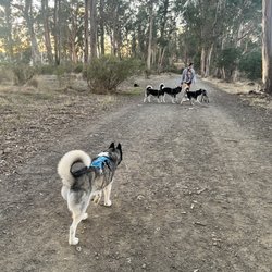
Dog Friendly Hiking Trails in Fairfax, California
Redwood Trees in Fairfax, California
River Swimming in Fairfax, California
Dog Friendly Beaches in Fairfax, California
Photo Spots in Fairfax, California
Fishing Spots in Fairfax, California
Scenic View in Fairfax, California
Scenic Drive in Fairfax, California
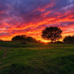
Watch Sunset in Fairfax, California
Sunrise View in Fairfax, California
Natural Hot Springs in Fairfax, California
Things to Do on a Rainy Day in Fairfax, California
Picnic Spots in Fairfax, California
Trending Searches in Fairfax, CA
Browse Articles
Browse Nearby
BEST of Fairfax, California Restaurants near Cataract Falls Trail
BEST of Fairfax, California Coffee near Cataract Falls Trail
BEST of Fairfax, California Things to Do near Cataract Falls Trail
BEST of Fairfax, California Breakfast near Cataract Falls Trail
BEST of Fairfax, California Beaches near Cataract Falls Trail
BEST of Fairfax, California Campgrounds near Cataract Falls Trail
Browse Brands
Related Searches in Fairfax, CA
Affordable Kayak Rental Services in Fairfax, California
Best Fishing Locations and Guides in Fairfax, California
Best Nature Trails for Hiking in Fairfax, California
Best Places for Horseback Riding in Fairfax, California
Best Waterfalls and Swimming Holes in Fairfax, California
Check Out Off Road Trails in Fairfax, California
Discover Dog Friendly Trails to Explore in Fairfax, California
Discover Kid Friendly Hiking Trails in Fairfax, California
Discover Scenic Hiking Trails in Fairfax, California
Discover Scenic Mountain Bike Trails Near Fairfax, California
Discover Scenic Waterfall Spots in Fairfax, California
Discover Walking Parks in Fairfax, California Near You
Discover a Hiking Trail in Fairfax, California
Discover the Best Night Hike Trails in Fairfax, California
Discover the Best Running Track in Fairfax, California
Dog-Friendly Hikes With Dogs in Fairfax, California
Enjoy Camping Adventures Around Fairfax, California
Enjoy Kayaking Adventures in Fairfax, California
Enjoy Tent Camping Spots Around Fairfax, California
Enjoy a Beautiful Waterfall Hike in Fairfax, California
Enjoy the Best Picnic Spots and Ideas in Fairfax, California
Enjoy the Best Walking Path in Fairfax, California
Enjoy the Best Walking Trails in Fairfax, California
Exciting Cliff Jumping Spots in Fairfax, California
Explore Beautiful Parks and Green Spaces in Fairfax, California
Explore Easy Hikes Perfect for All in Fairfax, California
Explore Fun Activities to Do in Fairfax, California
Explore Popular Campgrounds Near Fairfax, California
Explore the Best Beach Spots in Fairfax, California
Explore the Best Swimming Holes Around Fairfax, California
Explore the Best Trail Options in Fairfax, California
Family Friendly Hiking With Kids in Fairfax, California
Find Beautiful Views in Fairfax, California
Find the Best Parks for Picnics in Fairfax, California
Find the Best Scenic View Locations in Fairfax, California
Great Places to Walk in Fairfax, California
Hike the Popular Waterfall Trail in Fairfax, California
Hiking Trails With Waterfalls in Fairfax, California
Off Leash Dog Hiking Trails in Fairfax, California
Plan a Scenic Drive Route Near Fairfax, California
Popular Outdoor Activities to Try in Fairfax, California
Popular Picnic Spots to Visit in Fairfax, California
Safe River Swimming Areas in Fairfax, California
Safe and Fun Parks for Kids in Fairfax, California
Top Climbing Spots and Gyms in Fairfax, California
Top Running Trails to Explore in Fairfax, California
Top Swimming Lakes to Enjoy in Fairfax, California
Top Swimming Spots and Pools in Fairfax, California
People who viewed Cataract Falls Trail also viewed
Mount Tamalpais State Park
433 reviews
Tiburon Ridge Preserve
15 reviews
Slackers Hill
23 reviews
Morning Sun Trail
5 reviews
Muir Woods National Monument
1885 reviews
Hoo Koo E Koo Loop
8 reviews
Lands End Trail
986 reviews
Sea Cliff
Old St. Hilary's Open Space Nature Preserve
12 reviews
Lake Lagunitas
26 reviews
Cascade Park
4 reviews