Cascade Falls Photos


You might also consider
More like Cascade Falls
Recommended Reviews - Cascade Falls
Start your review...

Reviews With Photos


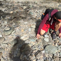
"Secret Way In!" Yes, it's true--there's a secret, and legal way in to this park and up to see the waterfalls. The secret way in is from the south, via a "secret" trail called Pine Mountain Tunnel Road. The Tunnel Road used to be closed to public access, but no more! It is a perfectly legal trail, with easements crossing private property. So please be respectful when you cross that area. (There's a great history to Pine Mountain tunnel, involving a huge water tunnel bored through the mountain about a hundred years ago!) Most maps do not show it, but there is a trail from Pine Mountain Tunnel Road to Carey Camp Trail. I know for positive, because that's how I came to the Falls today! Even though the trail does not show up on most Maps, it is physically marked very clearly with official Park signs at the trailhead. You can bike on Pine Mountain Tunnel Road, but when you go to Carey Camp Trail, you have to leave your bike behind. I put mine next to some trees and hiked down in my mountain biking shoes on the Carey Camp Trail. The main trail to the falls takes you several times through the creek. The day that I visited, the creek was completely dry, but oftentimes you will need to take the bypass trail. Today, the waterfall was in full splendor! Really a big nificent sight to see. (For the geocachers in the group, there is a big geocache on the traul beyond the Falls.) As others have noted, there aren't any restrooms, and the parking on Cascade is very limited. That's why I took the tricky way in! However, I also discovered how poor my mountain biking shoes are for hiking on terrain.

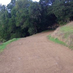
Cascade Falls is a cute little neighborhood waterfall. If coming all the way from the city or East Bay specifically to do a waterfall hike it's probably better to do Carson or Cataract, but if you've been there done that and are looking for a short little hike this is a good option. The trail starts at the end of a residential street with extremely limited parking. Because of this it seems like more locals that live on Cascade drive do this hike. The waterfall takes about 20-30 minutes to get to from the beginning of the trailhead. During the rainy season there is a running stream adjacent to the path most of the way there which dries up in later months. During this time it can get quite muddy in some areas so it might be a good idea to bring hiking boots or pole. The waterfall is beautiful and lush. I think it's best to go a few weeks after the rainy season as it's still running heavily but the trails aren't as muddy. The falls dry up by the end of May.

I came here after doing some research on waterfall hikes in the SF area. Cascade Falls and the greater Cascade Canyon Open Space Preserve was a really lowkey, relaxing hike. The trail is mainly flat, with some uphill/down hill areas. There are 3 parts where you have to cross over a stream/rocks but it's not too difficult to walk across. There are many trails you can walk, not just the trail to the water fall, which is nice if you're looking for a longer hike. Starting at the Elliot Nature Preserve entrance (off of Cascade Falls Drive) the walk to the waterfall is about 1mile one way (2mi round trip). I loved it. It's very family-friendly too as I saw a about 5 groups of folks with kids and strollers.

Don't go chasing waterfalls...Please stick to the rivers and the lakes that you're used to.. remember that song? Since El nino is around still, I figure why not find a waterfall. Cascade Falls was next on my list. The 2-mile round trip hike along the High Water Trail undulated on some minor hills with some minor dropoff exposure and some minor rock hopping on tributary streams. A simple hike but prepared for some muddy ground and some wet socks. The hike itself is not all flat, there are parts you will need to go up hill but anyone can do it! Stay toward the right of your path and you will hit the waterfall at the top. FYI.. do not use Google Maps for directions, it took me 10mins off from the drive onto some other hike. LOL USE YELP address.

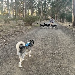
This is a wonderful little-known dog-friendly hike, reminiscent of Cataract falls but much easier. The beginning of the hike follows along a beautiful flowing creek, you will pass through fern meadows and cross bridges. The waterfall is a decent size and is gorgeous. It's an easy 1.5 mile round-trip hike with only 250ft elevation gain. You can extend your hike through several connecting trails. We hiked this trail while it was raining, and I highly recommend doing the same or hiking just after a rain to see the waterfall in full force. Parking is tricky and very limited, so I recommend going early. No parking is allowed in front of the gate at the trailhead. Very limited street parking is available on the right side of the street only, in the pullouts off of the pavement (room for about 4 cars). No parking is allowed on the pavement or on the left side of the street. If no parking is available here, you may need to park about a mile back where there is curbed street parking. A garbage can and doggy clean up bags are available at the trailhead. There are no restrooms or water faucets available.


My friend and I wanted to take advantage of the break in the rain over the weekend. We figured due to all the rain, the waterfall trails in the Bay Area would be born again! We yelped and found this beautiful trail! A nice drive to the trail head. We came on a weekday afternoon so parking was easy. No parking on the street and there is no parking lot. You got to find a turnout spot on the side of the road making sure to respect the neighbors . A nice, calm, easy and relaxing walk in the park. Beautiful river and amazing falls. Now is the time to go since the heavy rain keeps the Falls flowing good!

I did not like this place...maybe coz I went right in the middle of summer. It was really dry. But I could imagine going here after the rain, it must be really really pretty. I missed it :( I decided to go here after watching the movie IT ... When we started hiking there was no one in sight. The only sound was a kid screaming so far away. Also there was this house right by the entrance which looks like this umm hoppers house in stranger things (lol). So i did manage to go half way but I got so scared, I freaked out and turned around. The whole time I had this thought running in my mind that o Lord what if I actually see a clown bahahahaha. Anyways I did manage to take so good pics. The side from where I entered there was no parking so u have to find parking in front of houses. I would want go back during rain, just to see thebflowing water and the waterfall.
 | www.eddie-hernandez.com")
Cascade can be somewhat confusing. There are two sets of waterfalls that can be reached at each split on the fork in the road. One set is the lazy man's hike (which is the shortest hike I've ever traveled to see a waterfall, the other is a bit longer to get to ~15 minutes). Neither proved to be that great to look at. The larger of the two waterfalls is about 20 feet which is nothing special after you've seen all the best waterfalls in Marin like I have before this one. There are plenty of better hikes and certainly plenty of better waterfalls in Marin - call me a little snobbish but I know my hikes and waterfalls. Getting here can be a pain in the butt as you'll have to start this hike from a residential street that has prohibited parking at the end of the street. This is a very amateurish hike that can be perfect if you're a total beginner or looking for something quick and easy. =============== For more hiking recommendations: http://www.yelp.com/list_details?list_id=kc_cpimm3r3OA07lrBGKBA
Planned a Sunday hike for the cousins since everyone was trying to be more active this year. We had ages 4 months to 40 years old on this hike, so I picked a fairly easier hike. The way there was simple from San Jose. It took about 1 hour and 30 mins to get to the hiking grounds. This is basically someones back yard! There is only street parking and it fills up rather quickly. We got to the hiking grounds at 9:30am after frantically looking for parking for 5 vehicles. We had some disagreements about which route to take to get to the falls. It is less than 1 miles round trip, which is a good starter hike for our new comers. It had just rained that week, so the ground was moist and some parts muddy. We even had to cross the river in order to get back to some parts of the trail. Either way you take, it'll take you up to the falls. Compared to other falls in the bay area, this is not really a big one, nor were there any alternative trails to keep walking around. If I lived closer to here, I would come more often, but this was not worth the drive for me. It still is a beautiful hike! Do not, I repeat, do not, come off season. The falls will be none existent!

Fun small hike, we finished in less than half an hour! Dog friendly! Parking is limited nearby, be sure to read the signs and park on the correct side of the street! Ran into quite a few hikers along the way and tons of people on bikes. Don't follow your GPS, it will take you up a crazy hill onto private property. Bring a small blanket and have a nice lunch picnic near the small waterfall.

3/21/2026 On the way back from Cataract Falls Trail in Fairfax, CA, we decided to stop by the Cascade Falls we visited last year with no water, all dried up. Since the Cataract Falls had water this time, we believed Cascade would too. It wasn't far from Cataract Falls, but if we drove from the East bay it would take more than an hour through 880 north 80 - 580 - Fairfax downtown. The hardest part of the trail is to find the parking space on the road to the trail. All along the street has no parking signs, we had to park almost a mile from the gate of the trail park. The hike is about 1.5 miles and uphill but not too hard. There are 2 trails to get to the Falls, on the way to the fall we used the right trail, on the way back, we used the left trail. The left trail is easier, wider than the right trail, both are on either side of the creek. This time, the water is there, very nice, although not many people there due to parking we guess. Anyhow, it's a quest that's successfully achieved for us. We had lunch at the top of the falls, all by ourselves which was nice. The next one will be Burney Falls. https://youtu.be/eHk-oivo32w read more


2 years ago
Serenity now! Get ready for a great hike, a wonderful workout with such an incredible nature view of magnificent trees, rocks, water, ferns, birds, clean air, etc etc Cascade Fall trail is near Mill Valley, California. There are several paths from easily to moderately challenging route, it takes an average of 30 min to complete. This is absolutely my favorite trail for solitude, mindfulness. birding, hiking, and walking, Parking is a bit tough but if you can get there early, you can easily find a spot. The trail is open year-round and is beautiful to visit anytime. Dogs are welcome, but must be on a leash. Enjoy! read more


2 years ago
Love it, just chasing the waterfall... better to hike right after rainy season to catch a full waterfall, nice short hike anyone can do it... read more


"Secret Way In!" Yes, it's true--there's a secret, and legal way in to this park and up to see the waterfalls. The secret way in is from the south, via a "secret" trail called Pine Mountain Tunnel Road. The Tunnel Road used to be closed to public access, but no more! It is a perfectly legal trail, with easements crossing private property. So please be respectful when you cross that area. (There's a great history to Pine Mountain tunnel, involving a huge water tunnel bored through the mountain about a hundred years ago!) Most maps do not show it, but there is a trail from Pine Mountain Tunnel Road to Carey Camp Trail. I know for positive, because that's how I came to the Falls today! Even though the trail does not show up on most Maps, it is physically marked very clearly with official Park signs at the trailhead. You can bike on Pine Mountain Tunnel Road, but when you go to Carey Camp Trail, you have to leave your bike behind. I put mine next to some trees and hiked down in my mountain biking shoes on the Carey Camp Trail. The main trail to the falls takes you several times through the creek. The day that I visited, the creek was completely dry, but oftentimes you will need to take the bypass trail. Today, the waterfall was in full splendor! Really a big nificent sight to see. (For the geocachers in the group, there is a big geocache on the traul beyond the Falls.) As others have noted, there aren't any restrooms, and the parking on Cascade is very limited. That's why I took the tricky way in! However, I also discovered how poor my mountain biking shoes are for hiking on terrain. read more


Cascade Falls is a cute little neighborhood waterfall. If coming all the way from the city or East Bay specifically to do a waterfall hike it's probably better to do Carson or Cataract, but if you've been there done that and are looking for a short little hike this is a good option. The trail starts at the end of a residential street with extremely limited parking. Because of this it seems like more locals that live on Cascade drive do this hike. The waterfall takes about 20-30 minutes to get to from the beginning of the trailhead. During the rainy season there is a running stream adjacent to the path most of the way there which dries up in later months. During this time it can get quite muddy in some areas so it might be a good idea to bring hiking boots or pole. The waterfall is beautiful and lush. I think it's best to go a few weeks after the rainy season as it's still running heavily but the trails aren't as muddy. The falls dry up by the end of May. read more

4 years ago
I came here after doing some research on waterfall hikes in the SF area. Cascade Falls and the greater Cascade Canyon Open Space Preserve was a really lowkey, relaxing hike. The trail is mainly flat, with some uphill/down hill areas. There are 3 parts where you have to cross over a stream/rocks but it's not too difficult to walk across. There are many trails you can walk, not just the trail to the water fall, which is nice if you're looking for a longer hike. Starting at the Elliot Nature Preserve entrance (off of Cascade Falls Drive) the walk to the waterfall is about 1mile one way (2mi round trip). I loved it. It's very family-friendly too as I saw a about 5 groups of folks with kids and strollers. read more


Don't go chasing waterfalls...Please stick to the rivers and the lakes that you're used to.. remember that song? Since El nino is around still, I figure why not find a waterfall. Cascade Falls was next on my list. The 2-mile round trip hike along the High Water Trail undulated on some minor hills with some minor dropoff exposure and some minor rock hopping on tributary streams. A simple hike but prepared for some muddy ground and some wet socks. The hike itself is not all flat, there are parts you will need to go up hill but anyone can do it! Stay toward the right of your path and you will hit the waterfall at the top. FYI.. do not use Google Maps for directions, it took me 10mins off from the drive onto some other hike. LOL USE YELP address. read more


10 years ago
This is a wonderful little-known dog-friendly hike, reminiscent of Cataract falls but much easier. The beginning of the hike follows along a beautiful flowing creek, you will pass through fern meadows and cross bridges. The waterfall is a decent size and is gorgeous. It's an easy 1.5 mile round-trip hike with only 250ft elevation gain. You can extend your hike through several connecting trails. We hiked this trail while it was raining, and I highly recommend doing the same or hiking just after a rain to see the waterfall in full force. Parking is tricky and very limited, so I recommend going early. No parking is allowed in front of the gate at the trailhead. Very limited street parking is available on the right side of the street only, in the pullouts off of the pavement (room for about 4 cars). No parking is allowed on the pavement or on the left side of the street. If no parking is available here, you may need to park about a mile back where there is curbed street parking. A garbage can and doggy clean up bags are available at the trailhead. There are no restrooms or water faucets available. read more


5 years ago
Very limited parking so best to avoid weekends if possible. Easy walking with some stepping stones to cross the creek if you follow the fire road. read more

My friend and I wanted to take advantage of the break in the rain over the weekend. We figured due to all the rain, the waterfall trails in the Bay Area would be born again! We yelped and found this beautiful trail! A nice drive to the trail head. We came on a weekday afternoon so parking was easy. No parking on the street and there is no parking lot. You got to find a turnout spot on the side of the road making sure to respect the neighbors . A nice, calm, easy and relaxing walk in the park. Beautiful river and amazing falls. Now is the time to go since the heavy rain keeps the Falls flowing good! read more


9 years ago
I did not like this place...maybe coz I went right in the middle of summer. It was really dry. But I could imagine going here after the rain, it must be really really pretty. I missed it :( I decided to go here after watching the movie IT ... When we started hiking there was no one in sight. The only sound was a kid screaming so far away. Also there was this house right by the entrance which looks like this umm hoppers house in stranger things (lol). So i did manage to go half way but I got so scared, I freaked out and turned around. The whole time I had this thought running in my mind that o Lord what if I actually see a clown bahahahaha. Anyways I did manage to take so good pics. The side from where I entered there was no parking so u have to find parking in front of houses. I would want go back during rain, just to see thebflowing water and the waterfall. read more


Cascade can be somewhat confusing. There are two sets of waterfalls that can be reached at each split on the fork in the road. One set is the lazy man's hike (which is the shortest hike I've ever traveled to see a waterfall, the other is a bit longer to get to ~15 minutes). Neither proved to be that great to look at. The larger of the two waterfalls is about 20 feet which is nothing special after you've seen all the best waterfalls in Marin like I have before this one. There are plenty of better hikes and certainly plenty of better waterfalls in Marin - call me a little snobbish but I know my hikes and waterfalls. Getting here can be a pain in the butt as you'll have to start this hike from a residential street that has prohibited parking at the end of the street. This is a very amateurish hike that can be perfect if you're a total beginner or looking for something quick and easy. =============== For more hiking recommendations: http://www.yelp.com/list_details?list_id=kc_cpimm3r3OA07lrBGKBA read more
 | www.eddie-hernandez.com - Parks Near Me")
 | www.eddie-hernandez.com - Parks Near Me")
No parking at the entrance, dried up creek, wide trails, quick walk, and small waterfall. Overall, I came here because Carson falls had a closure. No service in the area resulted in a nearby trail. I do recommend this trail for families! read more


Planned a Sunday hike for the cousins since everyone was trying to be more active this year. We had ages 4 months to 40 years old on this hike, so I picked a fairly easier hike. The way there was simple from San Jose. It took about 1 hour and 30 mins to get to the hiking grounds. This is basically someones back yard! There is only street parking and it fills up rather quickly. We got to the hiking grounds at 9:30am after frantically looking for parking for 5 vehicles. We had some disagreements about which route to take to get to the falls. It is less than 1 miles round trip, which is a good starter hike for our new comers. It had just rained that week, so the ground was moist and some parts muddy. We even had to cross the river in order to get back to some parts of the trail. Either way you take, it'll take you up to the falls. Compared to other falls in the bay area, this is not really a big one, nor were there any alternative trails to keep walking around. If I lived closer to here, I would come more often, but this was not worth the drive for me. It still is a beautiful hike! Do not, I repeat, do not, come off season. The falls will be none existent! read more


8 years ago
Fun small hike, we finished in less than half an hour! Dog friendly! Parking is limited nearby, be sure to read the signs and park on the correct side of the street! Ran into quite a few hikers along the way and tons of people on bikes. Don't follow your GPS, it will take you up a crazy hill onto private property. Bring a small blanket and have a nice lunch picnic near the small waterfall. read more


7 years ago
18 years ago
Take Cascade Drive all the way until you see a sign for Cascade Falls, and prepare for a pleasant stroll! This is a great 20 minute walk that includes a bridge, a nice waterfall (bench included), and a walk back to where you parked. Perfect for a light walk with a date :) read more


16 years ago
We went here on Thanksgiving morning. It was rather empty, other than the bicyclists who apparently had a thanksgiving biking event. Anyway, it was very beautiful hike with colorful leaves falling covering the ground along San Anselmo river. The waterfall itself.. only trickling due to limited amount of rain we got. Follow the trail on the right (east) side of the Creek to a bridge over Cascade Creek about a half-mile from the trail. Cross the bridge and follow Cascade Creek up to the falls. Small waterfall, only 30 ft. Uninteresting but the way there.. was almost magical. read more


15 years ago
10 years ago
This is a great hike for beginners. 2.4 miles all around. Me and friend went hiking for the first time and we had so much fun. The trail isn't too steep. We got our butts dirty by climbing the water fall that unfortunately had no water running through in the month of July. Probably because of this drought. Oh and to add, the stairs at the end of the trail leading to the waterfall are gorgeous! Great photo opp. Overall so easy and so worth it. You can can even bring children. read more


13 years ago
10 years ago
Parking is scarce here at the roads end for the trailhead. You might want to park back where there is still street parking and wLk in. So I hiked The fairly short hike to these falls about five years ago. Though small it was very surprising and cool to see such beautiful little falls out in Fairfax! I recommend driving out and hiking the short hike to these lovely little falls. Watch how close you stand at the top for pictures, it's slippery. read more

10 years ago
I did this on a day trip. I didn't realize that it simply just ends once you get to the waterfall that was kinda confusing but it was ok the waterfall was so pretty but realize there aren't toilets anywhere. I'm happy they allow dogs on this trail. Go early in season since we are late season w plenty of rain I went this month in April. Still some flowers blooming and creek on left as you walk to the waterfall. Really easy hike for kids, anyone. read more


9 years ago
We have been going here for a while but have not reviewed it yet. If you have never been here before it is a must. Parking can be hard but if you go early in the day it's not bad. drive till you see a sign that says no parking beyond this point and then you can turn around and find the closest parking spot just try not to park on the actual road. The hike in is beautiful and you walk along a flowing stream that you can walk down to at almost anytime along the trail. You will then get to a wood bridge to cross the stream at this point take the trail to the right! There is no sign saying waterfalls this way so make sure to take the trail to the right! If you take the trail to the left it just takes you up a hill away from the falls. From this point the falls is about a half mile away. Once you get to the falls you can crawl down some rocks and sit next to it and picnic or hang out or you can go up to the look out point and climb up some rocks and continue on above the falls. This is a great falls if you love nature this is a must! read more


7 years ago
12 years ago
This Waterfall is a hidden treasure of the Bay Area. Actually there are two waterfalls a short 15 minute walk from each other. Not really big waterfalls, water only drops about 20 ft in the larger falls, but they are still nice to watch and there is something special in listening to the sound of running water over the falls. Really nice area for a hike or picnic. Even though it's about a mile from downtown Fairfax you will feel like you are out in the wilderness. To get to it from the San Rafael Transit Center: Take Golden Gate Transit Route 23 Westbound. Get off at Fairfax. Walk down Bolinas Road about .4 miles and make a right on Cascade Drive. Continue on Cascade Drive about .5 miles until the road dead ends in the preserve gate marking the beginning of your hike. Not too hard a walk if you take your time, there is a slight incline. Here's the bus schedule: http://www.goldengatetransit.org/schedules/pages/Bus-Schedules.php Bring a camera. Great place to get away from it all for awhile. read more


11 years ago
14 years ago
15 years ago
10 years ago
12 years ago
10 years ago
10 years ago
8 years ago
10 years ago
More info about Cascade Falls
Fairfax, CA 94930
Directions
(415) 388-4033
Call Now
Hours
Outdoor Amenities
Ask the Community - Cascade Falls
Is it open?
When is the best time to hike this trail?
Usually December through May are the best months and the best time of day is 9:00am-noon. Because it is not as hot in the day, easier to find parking and not to busy on the trails or at the falls.
Review Highlights - Cascade Falls
You might also consider


Why does Yelp recommend reviews?
1 review that is not currently recommended
The reviews below are not factored into the business's overall star rating.
13 years ago
Cascade Falls - parks - Updated June 2026
Best of Fairfax
People found Cascade Falls by searching for…
Trending Searches in Fairfax, CA
Baseball Fields near Cascade Falls
Black Owned Nail Salons near Cascade Falls
Boat Rental near Cascade Falls
Cliff Jumping near Cascade Falls
Dog Friendly Beaches near Cascade Falls
Fishing Spots near Cascade Falls
Free Kids Activities near Cascade Falls
Free Picnic Areas near Cascade Falls
Jet Ski Rental near Cascade Falls
Kids Activities Outdoor near Cascade Falls
Lakes & Ponds near Cascade Falls
Off Road Trails near Cascade Falls
Outdoor Activities near Cascade Falls
Outdoor Basketball Courts near Cascade Falls
Parks With Pull Up Bars near Cascade Falls
Pick Your Own Farms near Cascade Falls
Places To Walk Around near Cascade Falls
Public Beaches near Cascade Falls
Public Shower near Cascade Falls
Rock Quarry near Cascade Falls
Scenic Drive near Cascade Falls
Scenic Night View near Cascade Falls
Secluded Spots near Cascade Falls
Soccer Store near Cascade Falls
Strawberry Picking near Cascade Falls
Sunrise View near Cascade Falls
Swimming Holes near Cascade Falls
Swimming Lakes near Cascade Falls
Swimming Pools near Cascade Falls
View Fireworks near Cascade Falls
Watch Sunset near Cascade Falls
Browse Nearby
BEST of Fairfax, California Coffee near Cascade Falls
BEST of Fairfax, California Restaurants near Cascade Falls
BEST of Fairfax, California Things to Do near Cascade Falls
BEST of Fairfax, California Playgrounds near Cascade Falls
BEST of Fairfax, California Picnic Areas near Cascade Falls
BEST of Fairfax, California Breakfast near Cascade Falls
BEST of Fairfax, California Campgrounds near Cascade Falls
Browse Brands
Related Searches in Fairfax, CA
Affordable Kayak Rental Services in Fairfax, California
Best Fishing Locations and Guides in Fairfax, California
Best Nature Trails for Hiking in Fairfax, California
Best Off Leash Dog Parks in Fairfax, California
Best Parks for Parties and Events in Fairfax, California
Best Places for Horseback Riding in Fairfax, California
Best Water Parks for Kids in Fairfax, California
Best Waterfalls and Swimming Holes in Fairfax, California
Check Out Great Playgrounds in Fairfax, California
Check Out Off Road Trails in Fairfax, California
Discover Baseball Fields Around Fairfax, California
Discover Beautiful Garden Spots in Fairfax, California
Discover Dog Friendly Trails to Explore in Fairfax, California
Discover Free Parking Options in Fairfax, California
Discover Fun Toddler Parks in Fairfax, California for Your Little One
Discover Kid Friendly Hiking Trails in Fairfax, California
Discover Lakes & Ponds to Explore in Fairfax, California
Discover Popular Photo Spots in Fairfax, California
Discover Scenic Hiking Trails in Fairfax, California
Discover Scenic Mountain Bike Trails Near Fairfax, California
Discover Scenic Waterfall Spots in Fairfax, California
Discover Soccer Fields in Fairfax, California Near You
Discover Top Nature Parks to Visit in Fairfax, California
Discover Top State Parks to Visit in Fairfax, California
Discover Walking Parks in Fairfax, California Near You
Discover a Hiking Trail in Fairfax, California
Discover the Best Beaches in Fairfax, California
Discover the Best Kids Park Spots in Fairfax, California
Discover the Best Night Hike Trails in Fairfax, California
Discover the Best Running Track in Fairfax, California
Dog-Friendly Hikes With Dogs in Fairfax, California
Enjoy Camping Adventures Around Fairfax, California
Enjoy Kayaking Adventures in Fairfax, California
Enjoy Tent Camping Spots Around Fairfax, California
Enjoy a Beautiful Waterfall Hike in Fairfax, California
Enjoy the Best Picnic Spots and Ideas in Fairfax, California
Enjoy the Best Walking Path in Fairfax, California
Enjoy the Best Walking Trails in Fairfax, California
Exciting Cliff Jumping Spots in Fairfax, California
Explore Beautiful Botanical Gardens in Fairfax, California
Explore Beautiful Parks and Green Spaces in Fairfax, California
Explore Easy Hikes Perfect for All in Fairfax, California
Explore Family-Friendly Zoos and Wildlife in Fairfax, California
Explore Free Picnic Areas Around Fairfax, California
Explore Fun Activities to Do in Fairfax, California
Explore Parks With Pull Up Bars in Fairfax, California
Explore Popular Campgrounds Near Fairfax, California
Explore Popular Picnic Areas Around Fairfax, California
Explore Popular RV Parks Around Fairfax, California
Explore Popular Recreation Centers Around Fairfax, California