Roys Redwoods Preserve Photos


You might also consider
More like Roys Redwoods Preserve
Recommended Reviews - Roys Redwoods Preserve
Start your review...

Reviews With Photos

Ignore the map and park where you see the cars. My visit was in December and it was quite muddy in spots so we kept having to turn around and turn back because I had worn sneakers. However, the little we did see was charming. The City and Marin were fogged in, the sort of day where you couldn't see the bridge as you crossed it, but as you headed west to Nicasio, there were blue skies which made it so worth the drive. Plus there's cheese to be had nearby.

As many of the reviews have said, it's a lesser known redwood preserve trail. Probably a nice trail but DO NOT come here during the summer time for the hike!!!! Unless it's like early morning. There's not much shade for half the trail. The redwoods at the start are the Muir woods experience but the rest have intermittent redwoods mixed into the forest of just other trees Most people here just come and hang out near the redwood part at the start and chill with the redwoods. No need for the trail and all the horse poop

We went on a wonderful ~3-mile hike this morning. The weather was perfect and the hike was so scenic. Do watch out for the horse poop and poison oak on the way. Would recommend going early since there's not a lot of parking spots available and they seemed to have filled up by the time we got back.

Roy's Redwoods is a Marin County Open Space Preserve that has been recently upgraded. It has new trails that are suitable for the whole family -- even children in strollers . In past years, its trails were typical Marin Open Space hiking trails that went by some redwood stands. The new trails do a much better job of showcasing the redwood stands in the preserve.

This is a fairly easy 2.5 mile loop hike that takes about an hour. Half is shaded and half is sunny. This is a good hike if you want to get away from civilization, but you don't want to drive all the way out to West Marin. The best time to come is in the spring when it's green and the wildflowers are out. By the summer it gets really dry and dead and can get quite hot outside of the shaded parts. Be careful if you sit on any logs. I sat on a big log fairly close to the entrance and when I got up I realized there was a small rattlesnake curled up right behind me!

So here's your backup plan if you're scoffing at the advance reservations, the price points, or even worse, the crowds that come with a trip to Muir Woods. Never heard of it. Yeah, me neither... until I read an article about the best easy hikes in Marin in 7x7. This was on the list, and if you have the patience to make it to San Geronimo on Sir Francis Drake Blvd, then you're gold. You just turn north on Nicasio Valley Road and keep an eagle eye after about a half-mile since there's no signage from the road. I just noticed a couple of cars parked on the shoulder next to a redwood grove. And quite a grove it is as the trees are majestic as they tower over a stream right near the main entrance. But you're here to hike, and the 2-1/2-mile loop trail fits the bill. It starts out woodsy, and it's optimal if you take the detour onto the David Hansen Trail, a loop within a loop that gets you up close and personal with many of the old-growth redwoods. After you get back on the main loop, you eventually exit the woods for a long dull stretch on the open grasslands where you can watch the traffic dart by next to you. Eventually you make it back to the first redwood grove which will give you the faux-Muir Woods experience you're looking for anyway. RELATED - Up for a hike? Here's a collection of trails I've walked and reviewed: https://bit.ly/2OrC8nU


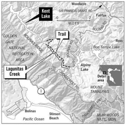
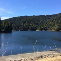
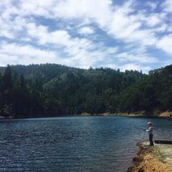
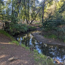
ROYS REDWOOD PRESERVE. This is about the loop trail that takes you around the preserve. About two thirds of the trail takes you through forested areas, and through occasional small open areas in the forest. A meadow trail starts and ends, on the loop trail. This meadow trail travels mainly through the small open areas. The loop trail includes the trailhead to the David Hansen Trail. David Hansen Trail takes you to the very center of Roys Redwood Preserve. Once at the very center of the Preserve you need to circle around on a small loop trail, and then return along David Hansen Trail to the main loop trail. About a quarter of the loop trail runs through an open meadow that is close to and parallel to Frances Drake Blvd. PHOTOGRAPHS. ( 1 ) Hiker on the loop trail, with a passing horse with rider. ( 2 ) Footbridge in the forest. ( 3 ) Footbridge in open area, located a few hundred feet north of Frances Drake Blvd. ( 4 ) Marker at trailhead for the loop trail. The marker reads, ROY'S REDWOOD LOOP TRAIL. Sir Frances Drake Blvd. can be seen in the background. ( 5 ) Marker pointing the way to ROY'S REDWOOD LOOP TRAIL, and also pointing to SPIRIT ROCK TRAIL. ( 6 ) Typical view of ferns growing next to ROY'S REDWOOD LOOP TRAIL. ( 7 ) View of nursery, as visible from the part of ROY'S REDWOOD LOOP TRAIL that runs parallel to Frances Drake Bvd. Red-colored flowers are in the nursery. ( 8 ) Bird flying out of a birdhouse. The birdhouse is situated on a post. The post is next to the fence that surrounds the nursery. ( 9 ) Green-colored fuller's teasel. During the past 20 years, for example, at Las Trampas park, at Tilden Park in Berkeley, and at Redwood Regional Park in Oakland, I never encounterd green-colored Fuller's teasel, but only the brown-colored dried out Fuller's teasel. ( 10 ) Brown-colored dried out Fuller's teasel. According to Midwest Invasitve Species Network (MISIN), Michigan State Univ., "Fuller's teasel is cultivated for use of the drie flower heads in wool processing. Stems reach 6 ft. in height, stem leaves are opposite, lanceolate and fused at base." ( 11 ) Pond situated across just west of Nicasio Valley Road, and only a couple of hundred feet north of Frances Drake Blvd. ( 12 ) Cattails located at edge of the pond ( 13 ) Boy holding a fish that he had just caught. Right after I took the photograph of the fish, the boy tossed the live fish back into the pond. ( 14 ) Typical view of one of the many shaded parts of ROY'S REDWOOD LOOP TRAIL. HOW TO FIND IT AND WHERE TO PARK. Roys Redwood Preserve can be accessed from Francis Drake Blvd. You can park next to the Club House at 5800 Francis Drake Blvd. This Club House is in San Geronimo, CA. About 50 feet north (uphill) from the Club House is the loop trail. This part of the loop trail runs parallel to Sir Francis Drake Blvd. Hiking the entire loop trail takes about one hour. THE LOOP TRAIL. A loop trail circles near the edge of Roys Redwood Preserve. The trail is easy to see from the Club House. The western edge of this loop trail travels close to Nicasio Valley Road (travels south to north). The loop trail is 3,000 feet at its widest, from east to west, and 2,600 feet at its longest, from north to south. My calculations show that the loop trail is about 1.7 miles long. The southern quarter of Roys Redwood Preserve is covered with tall light yellow dried out grasses and many bushes, but only a few trees. When hiking in this southern quarter of the loop trail, you can see Sir Francis Drake Blvd. On this part of the loop trail, I encountered a nursery where colorful flowers was bring raised. At the fence that encircles this nursery is a bird house, and I took a photo of a little bird flying out of the round hole in the bird house. The northern three quarters of Roys Redwood Preserve takes the form of a dense forest. The loop trail is a well-worn trail. During our hike in June 26, 2021, we passed two riders on horseback. The horses were walking slowly along the well-worn trail. THE POND. Near the west edge of Nicasio Valley Road is a pond (500 feet from north to south), where water-loving plants float around the edge of the pond. Also, thick clusters of cattails grow next to the northern part of the pond. During our visit, only one man was fishing. He cast his line out once every few minutes. The man' son (a boy, about 12 years old) was holding a fish that he had caught, and he let me take a photograph of the fish. Then, the boy replaced the live fish back into the pond.

What a gem this spot is. There are multiple trails & loops you can choose from. The trails are very well maintained. The diversity of the landscape is fantastic. Truly appreciated the areas for kids & also ADA friendly. We enjoyed seeing some majestic old and tall redwoods. Large detailed map at start of trails- we took a screen shot which was a big help. Thank you, Marin County Open Space District for keeping this park in tiptop shape! read more


Very peaceful. Plenty of parking along the road near the entrance when I went on a Thursday morning in summer. Follow the signs for several different trails--I did them all well within 2 hours, taking photos and pausing for soaking in the forest energy. Saw only a handful of other people. The Wilderness Trail is fun--hop onto the planks and redwood circles. The Fairy Ring trail has the largest circle of redwoods I noticed. Super fun to explore the shapes and just be around the energy of these giant trees. The redwoods are amazing--some are over 300 years only and 300 feet tall on this almost 300 acre area. Interesting facts: -Roy is the name of the family the owned that land in the 1800s. - A fairy ring is a circle of redwoods! read more


"A grove of giant redwoods or sequoias should be kept just as we keep a great and beautiful cathedral." -- Theodore Roosevelt The 3.2 stars average reviews are batshit crazy. This small grove has recently been updated with new accessible paths and wonderful children exploring areas. You can even make forts!! Can be combined with longer hikes. A wonderful free stop especially if you have children or are disabled. Even better when slightly wet or foggy. Highly recommended! read more


 - Parks Near Me - Marin, California")
3 months ago
Ignore the map and park where you see the cars. My visit was in December and it was quite muddy in spots so we kept having to turn around and turn back because I had worn sneakers. However, the little we did see was charming. The City and Marin were fogged in, the sort of day where you couldn't see the bridge as you crossed it, but as you headed west to Nicasio, there were blue skies which made it so worth the drive. Plus there's cheese to be had nearby. read more


As many of the reviews have said, it's a lesser known redwood preserve trail. Probably a nice trail but DO NOT come here during the summer time for the hike!!!! Unless it's like early morning. There's not much shade for half the trail. The redwoods at the start are the Muir woods experience but the rest have intermittent redwoods mixed into the forest of just other trees Most people here just come and hang out near the redwood part at the start and chill with the redwoods. No need for the trail and all the horse poop read more


We went on a wonderful ~3-mile hike this morning. The weather was perfect and the hike was so scenic. Do watch out for the horse poop and poison oak on the way. Would recommend going early since there's not a lot of parking spots available and they seemed to have filled up by the time we got back. read more


8 months ago
Roy's Redwoods is a Marin County Open Space Preserve that has been recently upgraded. It has new trails that are suitable for the whole family -- even children in strollers . In past years, its trails were typical Marin Open Space hiking trails that went by some redwood stands. The new trails do a much better job of showcasing the redwood stands in the preserve. read more


This is a fairly easy 2.5 mile loop hike that takes about an hour. Half is shaded and half is sunny. This is a good hike if you want to get away from civilization, but you don't want to drive all the way out to West Marin. The best time to come is in the spring when it's green and the wildflowers are out. By the summer it gets really dry and dead and can get quite hot outside of the shaded parts. Be careful if you sit on any logs. I sat on a big log fairly close to the entrance and when I got up I realized there was a small rattlesnake curled up right behind me! read more


So here's your backup plan if you're scoffing at the advance reservations, the price points, or even worse, the crowds that come with a trip to Muir Woods. Never heard of it. Yeah, me neither... until I read an article about the best easy hikes in Marin in 7x7. This was on the list, and if you have the patience to make it to San Geronimo on Sir Francis Drake Blvd, then you're gold. You just turn north on Nicasio Valley Road and keep an eagle eye after about a half-mile since there's no signage from the road. I just noticed a couple of cars parked on the shoulder next to a redwood grove. And quite a grove it is as the trees are majestic as they tower over a stream right near the main entrance. But you're here to hike, and the 2-1/2-mile loop trail fits the bill. It starts out woodsy, and it's optimal if you take the detour onto the David Hansen Trail, a loop within a loop that gets you up close and personal with many of the old-growth redwoods. After you get back on the main loop, you eventually exit the woods for a long dull stretch on the open grasslands where you can watch the traffic dart by next to you. Eventually you make it back to the first redwood grove which will give you the faux-Muir Woods experience you're looking for anyway. RELATED - Up for a hike? Here's a collection of trails I've walked and reviewed: https://bit.ly/2OrC8nU read more


5 years ago
They should change the name to Roy's Horse Poop Reserve! I spent the whole time watching for and smelling horse poop. Won't go back here waste of park resources ! Let the equestrians maintain it as it's their toilet. read more


ROYS REDWOOD PRESERVE. This is about the loop trail that takes you around the preserve. About two thirds of the trail takes you through forested areas, and through occasional small open areas in the forest. A meadow trail starts and ends, on the loop trail. This meadow trail travels mainly through the small open areas. The loop trail includes the trailhead to the David Hansen Trail. David Hansen Trail takes you to the very center of Roys Redwood Preserve. Once at the very center of the Preserve you need to circle around on a small loop trail, and then return along David Hansen Trail to the main loop trail. About a quarter of the loop trail runs through an open meadow that is close to and parallel to Frances Drake Blvd. PHOTOGRAPHS. ( 1 ) Hiker on the loop trail, with a passing horse with rider. ( 2 ) Footbridge in the forest. ( 3 ) Footbridge in open area, located a few hundred feet north of Frances Drake Blvd. ( 4 ) Marker at trailhead for the loop trail. The marker reads, ROY'S REDWOOD LOOP TRAIL. Sir Frances Drake Blvd. can be seen in the background. ( 5 ) Marker pointing the way to ROY'S REDWOOD LOOP TRAIL, and also pointing to SPIRIT ROCK TRAIL. ( 6 ) Typical view of ferns growing next to ROY'S REDWOOD LOOP TRAIL. ( 7 ) View of nursery, as visible from the part of ROY'S REDWOOD LOOP TRAIL that runs parallel to Frances Drake Bvd. Red-colored flowers are in the nursery. ( 8 ) Bird flying out of a birdhouse. The birdhouse is situated on a post. The post is next to the fence that surrounds the nursery. ( 9 ) Green-colored fuller's teasel. During the past 20 years, for example, at Las Trampas park, at Tilden Park in Berkeley, and at Redwood Regional Park in Oakland, I never encounterd green-colored Fuller's teasel, but only the brown-colored dried out Fuller's teasel. ( 10 ) Brown-colored dried out Fuller's teasel. According to Midwest Invasitve Species Network (MISIN), Michigan State Univ., "Fuller's teasel is cultivated for use of the drie flower heads in wool processing. Stems reach 6 ft. in height, stem leaves are opposite, lanceolate and fused at base." ( 11 ) Pond situated across just west of Nicasio Valley Road, and only a couple of hundred feet north of Frances Drake Blvd. ( 12 ) Cattails located at edge of the pond ( 13 ) Boy holding a fish that he had just caught. Right after I took the photograph of the fish, the boy tossed the live fish back into the pond. ( 14 ) Typical view of one of the many shaded parts of ROY'S REDWOOD LOOP TRAIL. HOW TO FIND IT AND WHERE TO PARK. Roys Redwood Preserve can be accessed from Francis Drake Blvd. You can park next to the Club House at 5800 Francis Drake Blvd. This Club House is in San Geronimo, CA. About 50 feet north (uphill) from the Club House is the loop trail. This part of the loop trail runs parallel to Sir Francis Drake Blvd. Hiking the entire loop trail takes about one hour. THE LOOP TRAIL. A loop trail circles near the edge of Roys Redwood Preserve. The trail is easy to see from the Club House. The western edge of this loop trail travels close to Nicasio Valley Road (travels south to north). The loop trail is 3,000 feet at its widest, from east to west, and 2,600 feet at its longest, from north to south. My calculations show that the loop trail is about 1.7 miles long. The southern quarter of Roys Redwood Preserve is covered with tall light yellow dried out grasses and many bushes, but only a few trees. When hiking in this southern quarter of the loop trail, you can see Sir Francis Drake Blvd. On this part of the loop trail, I encountered a nursery where colorful flowers was bring raised. At the fence that encircles this nursery is a bird house, and I took a photo of a little bird flying out of the round hole in the bird house. The northern three quarters of Roys Redwood Preserve takes the form of a dense forest. The loop trail is a well-worn trail. During our hike in June 26, 2021, we passed two riders on horseback. The horses were walking slowly along the well-worn trail. THE POND. Near the west edge of Nicasio Valley Road is a pond (500 feet from north to south), where water-loving plants float around the edge of the pond. Also, thick clusters of cattails grow next to the northern part of the pond. During our visit, only one man was fishing. He cast his line out once every few minutes. The man' son (a boy, about 12 years old) was holding a fish that he had caught, and he let me take a photograph of the fish. Then, the boy replaced the live fish back into the pond. read more


Someone up there? I was expecting an Ewok to jump out at me, at any moment. And, wishing to be a little Ewok for a bit, chilling out in the lush redwood groves. Absolutely beautiful! This place makes me believe Mother Nature loves me. There are trails for hiking, biking, horseback riding, and doggie strolling. The easy trails meander throughout a mixture of majestic redwoods and open meadows. Words cannot describe the beauty of those towering redwoods, so I'm going to stop here and just say - this place makes me wanna hug a tree. I'm in love. read more


7 years ago
9 years ago
9 years ago
More info about Roys Redwoods Preserve
Nicasio Valley Rd
Marin, CA 94973
Directions
Hours
Outdoor Amenities
Ask the Community - Roys Redwoods Preserve
Review Highlights - Roys Redwoods Preserve
You might also consider


Roys Redwoods Preserve - parks - Updated May 2026
Best of Marin
People found Roys Redwoods Preserve by searching for…
Redwood Trees in Marin, California
Campgrounds in Marin, California
Hiking Trails in Marin, California
Easy Hikes in Marin, California
Walking Trails in Marin, California
Photo Spots in Marin, California
Picnic Spots in Marin, California
Fishing Spots in Marin, California
Scenic Drive in Marin, California
Dog Friendly Hiking Trails in Marin, California
Beautiful Views in Marin, California
Redwood Forest in Marin, California
Camping Sites in Marin, California
Waterfall Hike in Marin, California
Things to Do in Marin, California
Scenic View in Marin, California
View Points in Marin, California
Running Trails in Marin, California
Dog Swimming in Marin, California
Toddler Park in Marin, California
Browse Nearby
BEST of Marin, California Coffee near Roys Redwoods Preserve
BEST of Marin, California Things to Do near Roys Redwoods Preserve
BEST of Marin, California Playgrounds near Roys Redwoods Preserve
BEST of Marin, California Restaurants near Roys Redwoods Preserve
BEST of Marin, California Breakfast near Roys Redwoods Preserve
BEST of Marin, California Hiking near Roys Redwoods Preserve
BEST of Marin, California Glamping near Roys Redwoods Preserve
BEST of Marin, California Campgrounds near Roys Redwoods Preserve