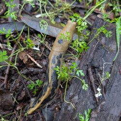
Samuel P Taylor State Park Photos


You might also consider
More like Samuel P Taylor State Park
Recommended Reviews - Samuel P Taylor State Park
Start your review...

Reviews With Photos

Samuel P. Taylor State Park is such a peaceful escape. We loved walking the forest trails and finding quiet spots like this one by the creek. The sound of the water and the shade from the trees made it the perfect place to slow down and recharge. It's a great spot for families--easy hikes, lots of shade, and plenty of places to explore or just sit and take it all in. There's something really grounding about being surrounded by redwoods and flowing water. We'll definitely be coming back with a picnic next time!

A treasure and gem 15 minutes from downtown San Rafael. I hadn't been here in more than 2 decades and I was pleasantly impressed on the serenity and accessibility of this magical redwood expanse with streams that are necessary to the habitat and survival of the coho salmon. I love nature, I love the redwoods, the smell, the fresh air, the retreat of getting out of the confines of daily life and renewing your perspective. Meditate Reflect, begin a new year.

I have always loved the day picnic spots but this time I was using the group spot. The reservation process was seamless and on the day of everything was blocked off accordingly and ready for use. The tablescape was set up by Picnic Potential for a rehearsal dinner and the space worked great for the occasion. The rangers were friendly and helpful, we will definitely be back.

We've spent afternoons at Samuel P Taylor State Park before, for hiking the paths. But this time we planned ahead and reserved a campsite (#16) for one evening for myself, my wife, grandson, and Gracie the Dog. We couldn't have chosen a more perfect spot. Nestled among towering redwoods, and right above the stream (still flowing strong even in July). The weather was perfect, and our site included both a fire pit and a barbecue. It was also close to a tap for water, and a 1 minute walk to the bathrooms. Camping with an electric car with V2L (vehicle to load) capabilities meant we were carrying a massive battery on wheels along with us and we put it to good use, powering our cooler-sized car refrigerator, pumping up our air mattress, and letting us leave our propane camp stove at home and instead use an induction burner. After setting up our tent, we climbed down a short embankment to the stream, then came back and took a walk along the paved bike path (no dogs allowed on any of the trails). The only issue with our campsite was it was close enough to Sir Francis Drake that we could hear traffic rushing by (though we were shielded from seeing them by the forest). I'd choose this site again, just for its location near the stream, though.

We have camped at Samuel P. Taylor campground a handful of times. If you're looking for a quiet trip, definitely go mid week, if you have children and are looking for a place that is playful for kids and less quiet, the weekends are when you'll want to go. This campground is very nice, extremely clean, and convenient. It's close to San Rafael, Point Reyes, and the little town of Olema, and not too far of a drive to Stinson Beach. The Earthquake Trail is only a couple of miles away and it's beautiful, lots of deer. There are also longer trails that are beautiful and accessible from the parking lot of the Earthquake Trail that go as far as the ocean - if you choose to do the longer trails, bring a lunch and snacks, they are about 4 - 5 hours round trip.

This is the second time I have visited here. The first time we visited over the summer and went hiking and had a picnic by the water while the kids wadded in the water (the pics are from the summer). It's a beautiful park, nice bathrooms, plenty of picnic tables under the shade. It cost 8.00 to park for the day. This time we went to see the salmon run, unfortunately we didn't spot any but enjoyed the walk along the water. We weren't able to go down to the water as you don't want to disturb the salmon. The water level was much higher and running fast. It's such a lovely park.

It is a very serene area filled with redwood trees. We went there this morning and hiked the Pioneer Tree Trail, which was very peaceful and a quick one hour and 20 mins hike (besides dodging the poison ivy and oak). Parking is easy (you have to scan the code and pay an $8 parking fee). The restrooms were clean, and they also have benches and tables for picnic areas as well as camping. We plan on coming back to hike their other trails or maybe camp here in the future.

Crazy asset for Bay Area peeps. This park on the outskirts of Marin Co. is so close, that within an hour's drive or less, you'll feel like much further away. It'll be a nice country drive where the hills start to get quite forested with even majestic redwoods starting to densely populate. I feel this is the place that started my love affair with heavily shaded redwood terrain. I was taken here as a child to camp and explore. And as I got older and started venturing out on my own, I constantly felt a pull to try and be close to this environment. An undeniable kinship. I spent a 4 day camping trip here in the early fall. It was glorious, perfect weather with lighter crowds than summer. There are nice hikes to be had in this park alone, but if you want to venture out, there are so many options within a short drive from here. In 3 short days, I was able to explore the Mt. Tamalpais Watershed, the Tomales Bay area and even to the coast behind the Point Reyes National Seashore. Truly an epic journey. Camping wise here are some observations: -Even though lighter crowds, the park does place most campers/reservations in the same areas. So you will still experience lots of people. Can't fault them on this, as people share my love for this park. -Very little ranger/employee representation. Actually outside of my check in, I never saw one again. Not a huge deal, but one night I could of used more firewood. No options to be found, where most other campsites, have that resource. -Bathrooms not the cleanest, but also not the worst. -Beautiful grounds. Super tall redwoods and ferns and a nice lively creek that flows through the park. If you don't want to camp, their day use area has some of the best-looking picnic grounds I've ever seen. There will be a fee for that as well. So even though I enjoyed my stay here, I still may opt to go elsewhere to camp, mostly due to my craving for more peace and solitude. And I know of more places that offer just that. But if ever pressed for time and just want a quick getaway, then this will get first dibs.


Awesome State Park to camp at. It is located in the town of Lagunitas, just past the town of Fairfax on Sir Francis Drake Boulevard. Even though the park is not that far from the town, it feels very remote. All campsites were surrounded by massive redwoods. All your typical campsite amenities are provided here, with the exception of the showers. They do have coin operated showers, however, the water is currently turned off because of the drought. You are able to purchase firewood at the guard shack when you drive in. My husband and I camped here for two nights late fall. It was very cold that time of the year, however, we still had a blast. Be prepared to come with lots of layers, and cold weather sleeping bags. Since we camped off season, there were hardly any of other campers. It felt like we had the whole forest to ourselves. We did not encounter much wildlife during our stay; just a few hungry racoons. Even though the campground is not as popular as others, reservations are still required. Reservations are $35/night. Overalll, a great place to camp and enjoy the outdoors.

This is a beautiful park in the Marin area. We came up on a Saturday to have a picnic lunch and do a lite hike. Big trees and a well maintained park with clean restrooms make this a nice experience. I do wish people would understand that you and everyone else are coming here to enjoy the serene forest, not your boombox jams, or shouting out to each other...Keep it down! And as is typical, so many people being disrespectful and not wearing masks when encountering others. Booo

What I should do is rate this place low so it stops being so busy. Alas, I've been going to SPT park since I was a child. My family has our annual 4th of July party here every year. Make sure you go early (I'm not going to tell you how early so I can keep getting my spot). We usually send someone down hours before the rest of us plan on getting there so we can grab the beat spot. It's the best place to go during a heat wave. The creek is ICY and the tree canopy keeps the air nice and cool. Kids will love playing in the creek, riding their bikes around the loop, and standing in old hollowed-out trees. Tip: please be respectful of the land and clean up after yourself. This place is pure magic.

This camping spot is great- tucked away in the redwoods. It has well maintained bathrooms and showers, hook ups and some of the spots are tucked away in the back so it feels less like you are around a bunch of people. The driving in is easy and the park rangers were friendly and helpful! Definitely not too far from San Francisco and the market in lagunitas is definitely accessible for fire wood and last minute snacks! There was cell phone reception at the site.

The drive into the area lets you know you're entering an absolutely gorgeous and special place. We haven't camped here yet, but we do have camping reservations for later this summer. Have been to the day use area a handful of times, and love it. Immersed in redwoods, it's a perfect place to enjoy reading a book, picnicking with loved ones, and learning about the days past of this former outdoor resort/gathering place. Bathrooms are simple and not stinky, so that's a win. Sometimes, there are bees aplenty, but that's nature so...deal with it and eat in your tent or van or ?? read more


Beautiful redwood park -- calm, shaded, and perfect for a low-stress day. What matters: * Baby-friendly (just watch uneven ground) * Bathrooms throughout (some have showers) * Parking is limited, so go early * Tons of shade * Lots of picnic tables * BBQ allowed * Campsites available * Dog-friendly, but only in picnic areas, campground, and the main trail (not most hiking trails) * No store -- bring everything Kids can roam, older kids can bike, and it's not overly crowded. Note: Creek access is closed seasonally (until June 15), so plan around that. Pro tip: bring a waterproof picnic blanket and plan to stay -- this is an all-day kind of place. Adding photos because it was hard to picture the layout before going. read more
 - Parks Near Me - Lagunitas, California")
 - Parks Near Me - Lagunitas, California")
 - Parks Near Me - Lagunitas, California")
 - Parks Near Me - Lagunitas, California")

 - Parks Near Me - Lagunitas, California")

Great campsite in the redwoods right next to the Lagunitas Creek!!! Super quiet and peaceful, just kick back , relax and listen to the birds in the trees. I love music but it feels wrong to play music when you could enjoy the sweet music provided by mother nature! We stayed in the orchard hill loop, nice and quiet and further from the road. Creekside campsites look really nice but you are right next to the road and probably a lot more skeeters at night, also you don't get creek access. I would recommend campsites 48,49, 51, 52, 59 and all the lower 40's sites looked nice but the numbers i listed have long driveways that are perfect for sprinter van/RV or multiple vehicles. Definitely will be back. Cheers! read more

Samuel P. Taylor State Park is such a peaceful escape. We loved walking the forest trails and finding quiet spots like this one by the creek. The sound of the water and the shade from the trees made it the perfect place to slow down and recharge. It's a great spot for families--easy hikes, lots of shade, and plenty of places to explore or just sit and take it all in. There's something really grounding about being surrounded by redwoods and flowing water. We'll definitely be coming back with a picnic next time! read more

A treasure and gem 15 minutes from downtown San Rafael. I hadn't been here in more than 2 decades and I was pleasantly impressed on the serenity and accessibility of this magical redwood expanse with streams that are necessary to the habitat and survival of the coho salmon. I love nature, I love the redwoods, the smell, the fresh air, the retreat of getting out of the confines of daily life and renewing your perspective. Meditate Reflect, begin a new year. read more

I have always loved the day picnic spots but this time I was using the group spot. The reservation process was seamless and on the day of everything was blocked off accordingly and ready for use. The tablescape was set up by Picnic Potential for a rehearsal dinner and the space worked great for the occasion. The rangers were friendly and helpful, we will definitely be back. read more


11 months ago
We've spent afternoons at Samuel P Taylor State Park before, for hiking the paths. But this time we planned ahead and reserved a campsite (#16) for one evening for myself, my wife, grandson, and Gracie the Dog. We couldn't have chosen a more perfect spot. Nestled among towering redwoods, and right above the stream (still flowing strong even in July). The weather was perfect, and our site included both a fire pit and a barbecue. It was also close to a tap for water, and a 1 minute walk to the bathrooms. Camping with an electric car with V2L (vehicle to load) capabilities meant we were carrying a massive battery on wheels along with us and we put it to good use, powering our cooler-sized car refrigerator, pumping up our air mattress, and letting us leave our propane camp stove at home and instead use an induction burner. After setting up our tent, we climbed down a short embankment to the stream, then came back and took a walk along the paved bike path (no dogs allowed on any of the trails). The only issue with our campsite was it was close enough to Sir Francis Drake that we could hear traffic rushing by (though we were shielded from seeing them by the forest). I'd choose this site again, just for its location near the stream, though. read more


2 years ago
We have camped at Samuel P. Taylor campground a handful of times. If you're looking for a quiet trip, definitely go mid week, if you have children and are looking for a place that is playful for kids and less quiet, the weekends are when you'll want to go. This campground is very nice, extremely clean, and convenient. It's close to San Rafael, Point Reyes, and the little town of Olema, and not too far of a drive to Stinson Beach. The Earthquake Trail is only a couple of miles away and it's beautiful, lots of deer. There are also longer trails that are beautiful and accessible from the parking lot of the Earthquake Trail that go as far as the ocean - if you choose to do the longer trails, bring a lunch and snacks, they are about 4 - 5 hours round trip. read more


This is the second time I have visited here. The first time we visited over the summer and went hiking and had a picnic by the water while the kids wadded in the water (the pics are from the summer). It's a beautiful park, nice bathrooms, plenty of picnic tables under the shade. It cost 8.00 to park for the day. This time we went to see the salmon run, unfortunately we didn't spot any but enjoyed the walk along the water. We weren't able to go down to the water as you don't want to disturb the salmon. The water level was much higher and running fast. It's such a lovely park. read more


It is a very serene area filled with redwood trees. We went there this morning and hiked the Pioneer Tree Trail, which was very peaceful and a quick one hour and 20 mins hike (besides dodging the poison ivy and oak). Parking is easy (you have to scan the code and pay an $8 parking fee). The restrooms were clean, and they also have benches and tables for picnic areas as well as camping. We plan on coming back to hike their other trails or maybe camp here in the future. read more


4 years ago
Crazy asset for Bay Area peeps. This park on the outskirts of Marin Co. is so close, that within an hour's drive or less, you'll feel like much further away. It'll be a nice country drive where the hills start to get quite forested with even majestic redwoods starting to densely populate. I feel this is the place that started my love affair with heavily shaded redwood terrain. I was taken here as a child to camp and explore. And as I got older and started venturing out on my own, I constantly felt a pull to try and be close to this environment. An undeniable kinship. I spent a 4 day camping trip here in the early fall. It was glorious, perfect weather with lighter crowds than summer. There are nice hikes to be had in this park alone, but if you want to venture out, there are so many options within a short drive from here. In 3 short days, I was able to explore the Mt. Tamalpais Watershed, the Tomales Bay area and even to the coast behind the Point Reyes National Seashore. Truly an epic journey. Camping wise here are some observations: -Even though lighter crowds, the park does place most campers/reservations in the same areas. So you will still experience lots of people. Can't fault them on this, as people share my love for this park. -Very little ranger/employee representation. Actually outside of my check in, I never saw one again. Not a huge deal, but one night I could of used more firewood. No options to be found, where most other campsites, have that resource. -Bathrooms not the cleanest, but also not the worst. -Beautiful grounds. Super tall redwoods and ferns and a nice lively creek that flows through the park. If you don't want to camp, their day use area has some of the best-looking picnic grounds I've ever seen. There will be a fee for that as well. So even though I enjoyed my stay here, I still may opt to go elsewhere to camp, mostly due to my craving for more peace and solitude. And I know of more places that offer just that. But if ever pressed for time and just want a quick getaway, then this will get first dibs. read more


1 year ago
2 years ago
Gorgeous campground. Hard to find it because it shoes a different camp sign. Paved road for dogs. Campsite was large enough for me, lots of tree which makes it a bit dark. Bicycles travel though and they think they have the right of way against pedestrians. Weird. read more

Awesome State Park to camp at. It is located in the town of Lagunitas, just past the town of Fairfax on Sir Francis Drake Boulevard. Even though the park is not that far from the town, it feels very remote. All campsites were surrounded by massive redwoods. All your typical campsite amenities are provided here, with the exception of the showers. They do have coin operated showers, however, the water is currently turned off because of the drought. You are able to purchase firewood at the guard shack when you drive in. My husband and I camped here for two nights late fall. It was very cold that time of the year, however, we still had a blast. Be prepared to come with lots of layers, and cold weather sleeping bags. Since we camped off season, there were hardly any of other campers. It felt like we had the whole forest to ourselves. We did not encounter much wildlife during our stay; just a few hungry racoons. Even though the campground is not as popular as others, reservations are still required. Reservations are $35/night. Overalll, a great place to camp and enjoy the outdoors. read more


This is a beautiful park in the Marin area. We came up on a Saturday to have a picnic lunch and do a lite hike. Big trees and a well maintained park with clean restrooms make this a nice experience. I do wish people would understand that you and everyone else are coming here to enjoy the serene forest, not your boombox jams, or shouting out to each other...Keep it down! And as is typical, so many people being disrespectful and not wearing masks when encountering others. Booo read more

What I should do is rate this place low so it stops being so busy. Alas, I've been going to SPT park since I was a child. My family has our annual 4th of July party here every year. Make sure you go early (I'm not going to tell you how early so I can keep getting my spot). We usually send someone down hours before the rest of us plan on getting there so we can grab the beat spot. It's the best place to go during a heat wave. The creek is ICY and the tree canopy keeps the air nice and cool. Kids will love playing in the creek, riding their bikes around the loop, and standing in old hollowed-out trees. Tip: please be respectful of the land and clean up after yourself. This place is pure magic. read more

This camping spot is great- tucked away in the redwoods. It has well maintained bathrooms and showers, hook ups and some of the spots are tucked away in the back so it feels less like you are around a bunch of people. The driving in is easy and the park rangers were friendly and helpful! Definitely not too far from San Francisco and the market in lagunitas is definitely accessible for fire wood and last minute snacks! There was cell phone reception at the site. read more


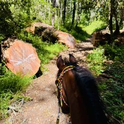
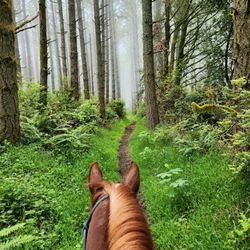
We loved our hike so much one day that we went back the next! It is a complete escape into a quiet, Redwood, nature-filled immersion experience, just a short drive from Marin or SF. We brought our dog, so many trails were off-limits, but there were miles of flat trails with great signage we explored. Wonderful facilities for camping, day picnics and grilling, biking, horses, and outdoor adventure. read more


 - Parks Near Me - Lagunitas, California")
7 years ago
August 17-18, 2019: OOOOOF~"How to make a lump of coal into a diamond" is another tale of the Nervous Chihuahua . . . FYI: I'm a decisively STUBBORN, highly independent, Disabled Vietnam Veteran where I never pay for any State Park Campsite because I applied for a Veterans' State Park Pass located via the Sacramento State Capitol (you may find my review regarding the contact information) . . . That's IF, IF you go to the State Park physically booking the campsite you want in advance in order, saving yourself AVOIDING spending Reserve America's CHUMP FEE . . . Did you catch the paragraph's operative wordings, eh? HOWEVER, my latest, obnoxious behavior has been akin as a stick stuck in gooey mud due to before 2017, I NEVER PAID A RESERVATION FEE VIA RESERVE AMERICA! Do you ponder IF, it is worth paying the $7.00 Reserve America's Chump Booking Fee which has the egregious gall and audacity charging Disabled Veterans? Well . . . As for speaking for myself~I'm still egregiously perturbed-no . . . LIVID being FORCED paying that-THAT FEE~GRRRRRRRR!!!!!!! Seriously, it's your decision, your discretion, and also, an egregiously, high risk gambling ruining your staycation plans . . . I guess~Shoulder shrugging ensues. Now, I'm going to be quite emphatic screaming at the top of my lungs . . . BIG HEADS UP-BOOK ANY CAMPSITE WAAAAAY, WAAAAAY IN ADVANCE, PEEPS-THAT'S ANYTIME, ANYPLACE, ANYWHERE: WHY, Shirley, WHY???? Well~I highly suggest AT LEAST, reserving ANY campsite in advance, allotting NO LESS THAN one to two months for the ultra-premium cabin or roomy-premium Creekside Campsite #7; possibly slithering-eeking by obtaining a smaller cabin or quasi-meager, below premium tent campsites by two to three weeks-that's IF you hit the Lottery (definitely not): Sadly, waiting last minute-NEVER, EVER PANS OUT, i.e., zilch, nada, zippo campsites will EVER BE AVAILABLE during beginning Friday to Sunday during summer-State and especially, Federal!!!! As a result of my recent experience-August 17-18, 2019~by idiotically not booking in advance AND MISERABLY FAILING reserving a campsite online: I ended camping at a primitive group campground at Devil's Gulch, since no disabled or other campsites were available TGIF~OY-EVAY. Regardless, the Samuel P. Taylor's, awesomely cool State Park Rangers were sympathetic recognizing my (Dufussly DUMB) plight-in fact, graciously allowing me staying at Campsite DG 3 BUT, the PRIMITIVE campsite severely lacked no showers nor flushing toilets AND typically, Veterans MUST PAY camping at ANY group campground! Just the atypical outhouse, pit toilets which were BEYOND PEPPY LA PEW, STINKY, TEARINGLY PUTRID, EYE-ROLL/PASSOUT STENCH . . . I wanted to regurgitate, i.e., HURL every time I had to use the AHEM! BTW: I took a shower before camping at Devil's Gulch so, I wouldn't feel sweaty, stinky . . . Wink-wink. Moral of this wing-it-via-the-seat-of-my-SKORT'S recent experience: Geez~Talk about being mushugginna frugal . . . Pay RESERVE AMERICA's fricking $7.00 CHUMP FEE, CHUMP Shirley-Capische????!!!! read more


My husband took the family here to check out the coho salmon spawning. We were only here for the day but it looks like an awesome place to camp. The park was serene and beautiful. As we hiked through the trails, you could hear the relaxing sounds of the water. The air smells so clean! All I can say is that it smells like nature. Coho salmon are endangered and coming here to see them swimming upstream to spawn was a spectacular sight to see. You can park here for a fee or you can park further up for free and walk down. We chose to purchase a Poppy Pass for $125 so that we can use it again for another visit (or for other state parks in Northern California). They sell it at the entrance. We will definitely return. read more

 swimming upstream to spawn (or fertilize the eggs laid by the females). Do you see them? - Parks Near Me - Lagunitas, California")


2 years ago
4 years ago
4 years ago
Stayed at The Devil's Gulch Campsite #3. It's a group campsite and the last camp spot on that road so it's away from the noisy road and other people. The Campsite is located near several trails with water at the site and restroom not to far away. Parking for 3 cars at the site otherwise more then that need to park at the Day Parking near the main entrance to pay the $8.00 fee. You can fit 4 tents comfortably in this spot with room, we had three tents and that was perfect for our group. Dogs are welcome at the camp but not on the trails so a heads up if you plan to bring you pet along and hike the trails near this Campsite. read more


6 years ago
4 years ago
3 years ago
Talk About Forest Bathing ... STUNNING! This is an absolutely breath-taking State Park as the sunlight filters through the gentle arms of the numerous breathing Redwoods that, if they could speak, would have endless stories to share. Came here this morning with one of my close friends and it took us a little under an hour and 15-minutes to get here from Walnut Creek. The sky was beautiful as it was clear and extremely windy, but upon arrival, the wind was nothing more than whispering breezes in and amongst these gentle giants. It was NOT crowded with people, as it is a State Park -- learned this from the Park Guide when we arrived and payed the "Day Use" Fee ($8.00). SHe told us that State Parks are NEVER as crowded as National Parks, such as Muir Woods National Park. I liked that this park was not inundated with people as one of the main reasons for coming here was to "get away" from the hustle and bustle. Certainly good to bring layers, and bundle up, as it was quite chilly. Also, there are a plethora of campsites in and among the redwoods, as well as plenty of picnic tables and areas to do BBQing. If you're just wanting to come for the day, and mentally realign, this is an exquisite place to visit. Although we did not see any salmon spawning, the Lagunitas Creek, that runs through this State Park, is one that these fish tend to do this activity in. It's hard to put into words just how exquisite the beauty is here, but my pictures should hopefully do it justice. Certainly a GORGEOUS HAVEN to visit as one will NOT be disappointed. PROMISE! :) read more


Really great grove of redwoods to picnic or camp under that's also close to home, within an hour of the Bay Area cities. The camp and picnic sites are pretty dispersed with plenty of social distancing. Note, it's a bit hard to book the camp sites for the weekend so plan ahead but there were plenty of first come first serve picnic sites. They had limited water signage so check the water status as well. Campsite is pet friendly and pets are allowed on paved trails as well. A number of great hikes nearby of varying difficulties as well as awesome bike trails. Because of the large group sites, it can get quite rowdy so bring earplugs if you need total silence. We found groups had boom boxes during the day and were loud well past 10pm so we needed ear plugs to fall asleep. I do wish the rangers would reinforce quiet time. But overall one of my favorite camp grounds because the canopy of redwoods and the running creek so close to home. read more


3 years ago
4 years ago
Great hiking trail. Parking is easy. 2.5ish miles to do the big trailhead. Bring water and hiking boots. read more


Beautiful...BEAUTIFUL... redwood forests without having to drive 574 hours and 11,345 miles to the Redwood National State Park. (Actually Google says its 284 miles and 4 hours 47 mins to get to Redwood National Park, but Samuel P Taylor Park is only 21.3 miles and 35 minutes from my hometown of Novato, CA.) Great wedding location too! read more


Page 1 of 6
More info about Samuel P Taylor State Park
8889 Sir Francis Drake Blvd
Lagunitas, CA 94938
Directions
(415) 488-9897
Call Now
Visit Website
https://www.parks.ca.gov/?page_id=469
Hours
Indoor Amenities
Outdoor Amenities
Other Amenities
From the Business
Ask the Community - Samuel P Taylor State Park
Is there phone reception at the camp ground?
I have gotten very sporadic cell phone reception (ATT). The Ranger stations has phones for emergencies.
It's been awhile since I've been here. Are the restrooms in the campgrounds stalled or are they single occupancy?
Our campsite loop had stalled toilets, but the showers were temporarily closed
Hello anybody know if they are really tracking the people capacity of six people right now ? My family have a planned trip and there's 8 of us.
They did not when we went and we had more than six. It helps if you're not all in one car which I'm sure you're not with that number but just a thought
I see that the cabins no longer offer mattresses. What do you recommend sleeping on? Is a Therma-Rest pad satisfactory? Or do I need something more, like an air mattress?
It depends on how comfy you want to be on a wooden board. I don't know what a Therma-Rest pad is like. We brought our regular camping gear, i.e. air mattresses for kids and thick, tri-fold mattresses for adults.
How much time do you need to schedule ahead for tent site or cabin?
FYI: I'm a Disabled Vietnam Veteran where I never pay for any State Park Campsite because I applied for a Veterans' State Park Pass located via the Sacramento State Capitol (you may find my review regarding the contact information) . . .… Read more
Has anyone tried to use site 39 with a trailer? Wondering if there is enough room to back a 27 travel trailer into that spot.
The Rangers will not let you in the front gate with anything over 27 feet
Does the Madrone Group camp area have a large BBQ pit? (for parties and reunions) or is it individual small grills?
Individual
Review Highlights - Samuel P Taylor State Park
You might also consider


Why does Yelp recommend reviews?
13 reviews that are not currently recommended
The reviews below are not factored into the business's overall star rating.
4 years ago
8 years ago
13 years ago
13 years ago
10 years ago
7 years ago
7 years ago
8 years ago
7 years ago
8 years ago
15 years ago
7 years ago
15 years ago
Samuel P Taylor State Park - parks - Updated July 2026
Best of Lagunitas
People found Samuel P Taylor State Park by searching for…
Rv Parks in Lagunitas, California
Swimming Holes in Lagunitas, California
Beaches in Lagunitas, California
Rv Campgrounds in Lagunitas, California
Long Term Rv Parking in Lagunitas, California
Hiking Trails With Waterfalls in Lagunitas, California
Fishing Spots in Lagunitas, California
Camping Cabins in Lagunitas, California
Redwood Trees in Lagunitas, California
Hiking in Lagunitas, California
Watch Sunset in Lagunitas, California
Glamping in Lagunitas, California
River Swimming in Lagunitas, California
Dog Friendly Beaches in Lagunitas, California
Dog Parks in Lagunitas, California
Dog Friendly Hiking Trails in Lagunitas, California
National Parks in Lagunitas, California
Picnic Spots in Lagunitas, California
Picnic Areas in Lagunitas, California
Things to Do in Lagunitas, California
Creeks in Lagunitas, California
Camping Equipment in Lagunitas, California
Browse Nearby
BEST of Lagunitas, California Coffee near Samuel P Taylor State Park
BEST of Lagunitas, California Things to Do near Samuel P Taylor State Park
BEST of Lagunitas, California Restaurants near Samuel P Taylor State Park
BEST of Lagunitas, California Hiking near Samuel P Taylor State Park
BEST of Lagunitas, California Breakfast near Samuel P Taylor State Park
BEST of Lagunitas, California Beaches near Samuel P Taylor State Park
BEST of Lagunitas, California Campgrounds near Samuel P Taylor State Park