Wildcat Camp Photos


You might also consider
More like Wildcat Camp
Recommended Reviews - Wildcat Camp
Start your review...

Reviews With Photos

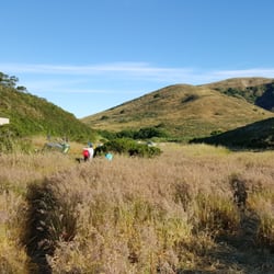
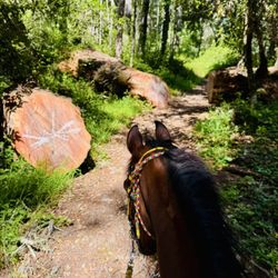
The campground in itself was beautiful. In very late June/early July, the shrubs were very high, giving every site a lot of privacy. The temperatures were great as well. Our one complaint was the horse poop. All along the path to the beach there were huge piles of it right in the middle of the path. We had two different groups bring horses while we were staying there and after they left we went to check out other sites. The main horse hitches are right next to site #6, and when we walked to it, about 3 feet away from the site there was a fresh pile of poop blocking the whole path. I pity whoever had to stay there next. The water was pretty clean, but we boiled it anyways. Site Reviews (see photos for reference): Site 1ab: Good sized site, with the most privacy out of all of the large group sites. It's also the closest large group site to the beach path (not by a huge distance though). Site 2ab: This is a very large site, with one huge main clearing with horse posts and room for a ton of tents, and another clearing off to the side on a short path, which you could fit another two or more tents in. The primary clearing is visible from the water spout, but not too close that it's uncomfortable. It's great for kids since it is so close to the bathrooms. Site 3ab: Lots and lots of room! You could fit a whole neighborhood in here! (Just kidding) There are multiple little clearings off the main area, which would be perfect for a multi-family trip as it offers a little bit of privacy (See photos). Site 4: If you're looking for privacy, this is not your site unless you plan to book site #8 as well. It is a cute sheltered site a little ways inland, with a path leading out to a cliff point, but it is directly next to site #8 for some reason with no plant separation at all. Site 4 does have it's table/tent space away from the bear boxes and grills which are directly next to each other (and site #8's tent space), but otherwise the site offers very little of the privacy one would expect. Site 5: This is a cute site with a short little path to the cliff. It has a large bear box, and is very private. It is the biggest of the small sites, and could fit 2+ tents. Site 6: This is your ultimate cliff views site. There is the main area where you can fit a tent or two, and a short trail leads to a spot around 20 feet from the cliffs edge where another tent could fit, and finally there is a spot on the very edge of the cliff one could sleep on without and possibly with a tent depending on tent size. This is perfect for a family with teenagers who want to sleep away from the family. It is close to the horse hitching posts though, so there might be horse poop on or near the path to your campsite. Site 7: This is where we stayed, it's sheltered from most of the wind, and is far away from the bathrooms. It is the closest small site to the beach. We loved it! Site 8: See site #4.

Wildcat is a magical hideaway for Bay Area backpackers. We went the weekend of February 16-17th. Trail Route: We took the recommended route from Bear Valley Visitor's Center down the Bear Valley fire road which thereafter connected to a series of trails that brought us to Wildcat. I recommend using AllTrails and tracking your course, as there were a number of side trails that we used that may not have been readily apparent without the app. We used the "Bear Valley Trail to Wildcat Camp and Alamere Falls" trail on AllTrails. See Photo for exact route and recording of our trek. Trail Conditions: It rained on us for about the first hour and half when we started out. This was along a fire road (about 2.5 miles right at the beginning). It was mostly sheltered by trees, but we got pretty wet. Once we got beyond the fire road the trail got a bit narrower. More like a traditional trail. This part of the trail was mostly clear but it seems as though a number of mountain bikers use the trail which creates a deep center rut through the trail that also becomes somewhat of a mini-river. You have to hop from side-to-side along the trail in many places. There were a few areas where we had to bushwhack around huge puddles of water. Waterproof hiking shoes recommended for this time of year. You don't get an ocean view until about the 4.5-5 mile mark. It is all a gradual uphill up to this point. Then once you see the ocean, it is a gradual downhill until you hit another fire road again. Then it's pretty straight downhill until you get to Wildcat. Wildcat Camp Campsites: There are technically 8 sites at Wildcat, but two of them are doubles (i.e. 1a & 1b, and 3a & 3b), which appear to be better for groups as they are right next to each other. I got pictures of every site except 7 (see my review pictures), which I think is probably the best, as it appears to have an ocean view and is pretty secluded from the other sites. There was someone in the site at the time so I didn't want to bug them with a photo. Definitely the best three sites at 5, 6 and 7. Site 6 has a really nice little path up to a 180 degree lookout of the beach. Gorgeous for catching the sunset or sunrise. A beautiful view. Site 5 also had a little path up to a lookout spot nearby and is also quite secluded. We were at Site 4, which actually shares a common space with Site 8. It looks like they are separate on Recreation.gov and other map photos, but they are right on top of each other. It would be a bummer to get Site 4 and have another group camped at Site 8, however, if you are looking for a group site, getting those two will mean you will all be in one location. The other sites that were right next to each other were 1a & 1b (appeared to be a group site) and 3a & 3b. Site 2a & 2b was also a group site. Closest to the bathrooms and trail, farthest from the ocean. Wildcat Camp Facilities: Every site has one picnic table, a bearbox and a grill - even the group sites that are split into two, with the exception of 3a & 3b which has one really large grill to be shared between the two. The grill on Site 8 (right next to the grill on Site 4) was pretty dilapidated. They could definitely invest about $1,000 to fix this camp up a bit. The camp also has a water spigot with potable water, two pit toilets and large trashcans that are in bearbox protected containers. It's my understanding that during the government shut down they had to turn off the water and there was no potable water there during that period, but it is back up and running again. Considering the current political climate, however, who knows when another shutdown may occur and I would hate for anyone to be without water! We did pass one or two streams but those were more towards beginning of the hike in. Other Things to Know: 1. No Campfires at Wildcat. This is a bummer, but better to know it now than get there are be disappointed. 2. Permits Required to camp here and are very hard to get, but you can show up at the Bear Valley Visitor's Center the day of and see if anyone bailed on their reservation. When we went, at least three sites were empty, but we thought that was likely because rain was in the forecast. It rained on us pretty much all night which made for a very muddy camp in the morning, still we loved it! 3. There are many ways to get to Wildcat camp. You can go the Alamere Falls way, but be forewarned that Alamere falls is the most popular hike in the entire park and by 9:30-10am the parking lot is full and car are lining the road in. Take my word for it, unless you plan on arriving early as hell, don't try it. You can't even pick up your permit until 9:00am when the Bear Valley Visitor's Center opens. From there, it's about a 40 minute drive to the Alamere Falls trailhead. You do the math. You can also hike in from Five Brooks (a bit of a boring route), Limatour Beach along the Coast trail (very scenic) or Sky Camp. All available options!

Awesome camping site so close to the city. I have stayed here twice. Once in July 2009, and again December 28, 2010. Both times at "coveted" number 7. This site is definitely the best, sitting on the bluff, right beside the ocean. Somewhat secluded from the other campers. As previously mentioned, this particular site is good for only 4, but making 2 tents fit will be challenging, unless they are both 2 person tents. Site has running water and a vault toilet. About a 6.2 mile hike from the headquarters, and only took us about 2 hours to get there. You can hike the beach to the base of Alamere Fall (about a mile), or take the trail at the horse's watering pit to the backside of the Fall. We hiked to the top of the Fall and had lunch overlooking the ocean. In July, the site is a little drab. Mostly brown, typical of summer in CA. The top of the Fall, though, was vibrant green with wildflowers. Winter months is nice, with lots of green, but good chance of rain. Be prepared!

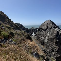
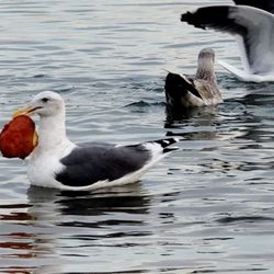
Super cool campground and definitely great for beginner backpackers since the trail is very well marked and you have a vault toilet and potable water there. Also can't deny the location, you really are a couple minute walk down to the beach. And yes there are wild animals that roam around here (we saw bobcat, deer, coyote, and tons of quails) Get permits early (6 months in advance is the earliest). Especially for weekends in the summer since the campground does get full. See here for permit costs information http://www.nps.gov/pore/planyourvisit/feesandreservations.htm Aerial view of the campsite (you can see it's a short walk down to the beach): http://www.nps.gov/pore/planyourvisit/upload/map_cg_wildcat.pdf Once you hike in (about a 5-6 miles easy to moderate hike via Bear Valley trail, there is a little bit of uphill climb), you can do a bunch of different day hikes from there. Take the Coast Trail is going to Alamere waterfall (a couple miles south) that starts behind the bathrooms. But go early in the morning since in the afternoon it becomes infested with A LOT of day hikers. Or you can walk south down the beach until you see Alamere waterfall. The reason why I didn't give this 5 stars is cuz it does get a little run over by a lot of backpackers and day hikers so you don't get the same sense of remoteness like you would get in the Sierras for instance. But for the location next to the beach and the fact that you can bring in a lot of heavy booze since it's not a challenging hike, it's still worth checking out! Photo of the bluffs on the trail hiking in: http://www.yelp.com/biz_photos/wildcat-camp-of-point-reyes-national-park-point-reyes-station?select=bCygzdIGhkbt-Xlw4wBb2A#bCygzdIGhkbt-Xlw4wBb2A Bobcat spotting by the vault bathrooms: http://www.yelp.com/biz_photos/wildcat-camp-of-point-reyes-national-park-point-reyes-station?select=k01_IUP2I7RXz7RGyJ9GoA#k01_IUP2I7RXz7RGyJ9GoA Our campsite #5 http://www.yelp.com/biz_photos/wildcat-camp-of-point-reyes-national-park-point-reyes-station?select=Q2Peof_W-PavatRvvmLMQg#Q2Peof_W-PavatRvvmLMQg
")

Fog is burning off. He fires up the Jetboil. She probes him: "Say, What is this little rat-tail thing you've got going on?" He has a short braided thing of hair hanging off the back of his head, like he's a Padawan apprentice or something. "What, this?" he laughs. "Party in the back?" In a thicket by the creek, they sip coffee. Song of the thrush ascends. Seems to spiral to heaven upward like a shell. They gaze through a seven foot tall cow parsnip at the sky. The umbels are bobbing galaxies in a vast universe. Ever expanding. Wielding a magic wand, she identifies the plant: "Heracleum maximum!" It has gigantic leaves. Each one is connected to a thick, hollow, densely-haired stem. She steers the huge leaves on their thick stems in her slender arms. Swipes away the poison oak. "Found a path to the creek," she says cheerily. Clear water riffles and splits around a shoal. It's sandy with willows and cattails. There is a great blue heron in the reeds. The heron saunters forward deceptively, like a starlet at the Croisette, then recoils its long neck and strikes. "Bill stab!" he exclaims. He purses his mouth, throws his arm up and makes a fist. Taking a beat, she observes the scene, and says wryly "Sick, huge fan. What a bird." The impaled fish writhes on the heron's spear in the sun, scales glinting. It has met its immutable fate. They sit on a bank dotted with Cyperaceae. Lady beetles fly about. They turn and face each other. "F#$%#g sh*# show that was..." he moans. "What do you mean? We shucked a thousand shells. You have to respect your aunt's stamina, it's a Vibe!" she says, grinning. The moment is fleeting. The song and the chirping and the thrum of insects in the morning heat. They kill the coffee. It's time to pack up their tent and go. "Check out time!" she says. "Pack it up!" read more

5 years ago
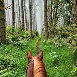
Beautiful campground and hike in, I took coast trail from bear valley and it was 8 miles... trail was very secluded after bear valley fire road... magical forest and garden surrounds the campgrounds. Camped at 2ab and it was ok, it was not very private and near the bathroom/water spigot so I felt like it was more people interaction than I cared for but that was what was available! The beach was a great place to relax after my hiking days and I loved it. I was there 3 days mid week in June and it was 75 one day and foggy/wet 60 degrees the other days, recommend rain fly for tents, and exploring the singletrack trails , they are so beautiful, full of wildlife read more


This campsite is one of the greatest location in the Bay Area. If you are a beginner and don't want to go backpacking in Eastern Sierra or Yosemite, this is close and easy in terms of distance and altitude. This site is 2 min from the beach and able to walk to Alamere falls on the beach. Each site is not close enough, so it's quiet. The problem in Marin County is that it is often foggy. If it is sunny, view is amazing. If it is foggy, still view is nice but I need to go back because I want to see clear sunny view as well. read more

7 years ago
The campground in itself was beautiful. In very late June/early July, the shrubs were very high, giving every site a lot of privacy. The temperatures were great as well. Our one complaint was the horse poop. All along the path to the beach there were huge piles of it right in the middle of the path. We had two different groups bring horses while we were staying there and after they left we went to check out other sites. The main horse hitches are right next to site #6, and when we walked to it, about 3 feet away from the site there was a fresh pile of poop blocking the whole path. I pity whoever had to stay there next. The water was pretty clean, but we boiled it anyways. Site Reviews (see photos for reference): Site 1ab: Good sized site, with the most privacy out of all of the large group sites. It's also the closest large group site to the beach path (not by a huge distance though). Site 2ab: This is a very large site, with one huge main clearing with horse posts and room for a ton of tents, and another clearing off to the side on a short path, which you could fit another two or more tents in. The primary clearing is visible from the water spout, but not too close that it's uncomfortable. It's great for kids since it is so close to the bathrooms. Site 3ab: Lots and lots of room! You could fit a whole neighborhood in here! (Just kidding) There are multiple little clearings off the main area, which would be perfect for a multi-family trip as it offers a little bit of privacy (See photos). Site 4: If you're looking for privacy, this is not your site unless you plan to book site #8 as well. It is a cute sheltered site a little ways inland, with a path leading out to a cliff point, but it is directly next to site #8 for some reason with no plant separation at all. Site 4 does have it's table/tent space away from the bear boxes and grills which are directly next to each other (and site #8's tent space), but otherwise the site offers very little of the privacy one would expect. Site 5: This is a cute site with a short little path to the cliff. It has a large bear box, and is very private. It is the biggest of the small sites, and could fit 2+ tents. Site 6: This is your ultimate cliff views site. There is the main area where you can fit a tent or two, and a short trail leads to a spot around 20 feet from the cliffs edge where another tent could fit, and finally there is a spot on the very edge of the cliff one could sleep on without and possibly with a tent depending on tent size. This is perfect for a family with teenagers who want to sleep away from the family. It is close to the horse hitching posts though, so there might be horse poop on or near the path to your campsite. Site 7: This is where we stayed, it's sheltered from most of the wind, and is far away from the bathrooms. It is the closest small site to the beach. We loved it! Site 8: See site #4. read more


7 years ago
Wildcat is a magical hideaway for Bay Area backpackers. We went the weekend of February 16-17th. Trail Route: We took the recommended route from Bear Valley Visitor's Center down the Bear Valley fire road which thereafter connected to a series of trails that brought us to Wildcat. I recommend using AllTrails and tracking your course, as there were a number of side trails that we used that may not have been readily apparent without the app. We used the "Bear Valley Trail to Wildcat Camp and Alamere Falls" trail on AllTrails. See Photo for exact route and recording of our trek. Trail Conditions: It rained on us for about the first hour and half when we started out. This was along a fire road (about 2.5 miles right at the beginning). It was mostly sheltered by trees, but we got pretty wet. Once we got beyond the fire road the trail got a bit narrower. More like a traditional trail. This part of the trail was mostly clear but it seems as though a number of mountain bikers use the trail which creates a deep center rut through the trail that also becomes somewhat of a mini-river. You have to hop from side-to-side along the trail in many places. There were a few areas where we had to bushwhack around huge puddles of water. Waterproof hiking shoes recommended for this time of year. You don't get an ocean view until about the 4.5-5 mile mark. It is all a gradual uphill up to this point. Then once you see the ocean, it is a gradual downhill until you hit another fire road again. Then it's pretty straight downhill until you get to Wildcat. Wildcat Camp Campsites: There are technically 8 sites at Wildcat, but two of them are doubles (i.e. 1a & 1b, and 3a & 3b), which appear to be better for groups as they are right next to each other. I got pictures of every site except 7 (see my review pictures), which I think is probably the best, as it appears to have an ocean view and is pretty secluded from the other sites. There was someone in the site at the time so I didn't want to bug them with a photo. Definitely the best three sites at 5, 6 and 7. Site 6 has a really nice little path up to a 180 degree lookout of the beach. Gorgeous for catching the sunset or sunrise. A beautiful view. Site 5 also had a little path up to a lookout spot nearby and is also quite secluded. We were at Site 4, which actually shares a common space with Site 8. It looks like they are separate on Recreation.gov and other map photos, but they are right on top of each other. It would be a bummer to get Site 4 and have another group camped at Site 8, however, if you are looking for a group site, getting those two will mean you will all be in one location. The other sites that were right next to each other were 1a & 1b (appeared to be a group site) and 3a & 3b. Site 2a & 2b was also a group site. Closest to the bathrooms and trail, farthest from the ocean. Wildcat Camp Facilities: Every site has one picnic table, a bearbox and a grill - even the group sites that are split into two, with the exception of 3a & 3b which has one really large grill to be shared between the two. The grill on Site 8 (right next to the grill on Site 4) was pretty dilapidated. They could definitely invest about $1,000 to fix this camp up a bit. The camp also has a water spigot with potable water, two pit toilets and large trashcans that are in bearbox protected containers. It's my understanding that during the government shut down they had to turn off the water and there was no potable water there during that period, but it is back up and running again. Considering the current political climate, however, who knows when another shutdown may occur and I would hate for anyone to be without water! We did pass one or two streams but those were more towards beginning of the hike in. Other Things to Know: 1. No Campfires at Wildcat. This is a bummer, but better to know it now than get there are be disappointed. 2. Permits Required to camp here and are very hard to get, but you can show up at the Bear Valley Visitor's Center the day of and see if anyone bailed on their reservation. When we went, at least three sites were empty, but we thought that was likely because rain was in the forecast. It rained on us pretty much all night which made for a very muddy camp in the morning, still we loved it! 3. There are many ways to get to Wildcat camp. You can go the Alamere Falls way, but be forewarned that Alamere falls is the most popular hike in the entire park and by 9:30-10am the parking lot is full and car are lining the road in. Take my word for it, unless you plan on arriving early as hell, don't try it. You can't even pick up your permit until 9:00am when the Bear Valley Visitor's Center opens. From there, it's about a 40 minute drive to the Alamere Falls trailhead. You do the math. You can also hike in from Five Brooks (a bit of a boring route), Limatour Beach along the Coast trail (very scenic) or Sky Camp. All available options! read more


16 years ago
Awesome camping site so close to the city. I have stayed here twice. Once in July 2009, and again December 28, 2010. Both times at "coveted" number 7. This site is definitely the best, sitting on the bluff, right beside the ocean. Somewhat secluded from the other campers. As previously mentioned, this particular site is good for only 4, but making 2 tents fit will be challenging, unless they are both 2 person tents. Site has running water and a vault toilet. About a 6.2 mile hike from the headquarters, and only took us about 2 hours to get there. You can hike the beach to the base of Alamere Fall (about a mile), or take the trail at the horse's watering pit to the backside of the Fall. We hiked to the top of the Fall and had lunch overlooking the ocean. In July, the site is a little drab. Mostly brown, typical of summer in CA. The top of the Fall, though, was vibrant green with wildflowers. Winter months is nice, with lots of green, but good chance of rain. Be prepared! read more

 right before the beach entrance. - Campgrounds Near Me - Point Reyes Station, California")


Super cool campground and definitely great for beginner backpackers since the trail is very well marked and you have a vault toilet and potable water there. Also can't deny the location, you really are a couple minute walk down to the beach. And yes there are wild animals that roam around here (we saw bobcat, deer, coyote, and tons of quails) Get permits early (6 months in advance is the earliest). Especially for weekends in the summer since the campground does get full. See here for permit costs information http://www.nps.gov/pore/planyourvisit/feesandreservations.htm Aerial view of the campsite (you can see it's a short walk down to the beach): http://www.nps.gov/pore/planyourvisit/upload/map_cg_wildcat.pdf Once you hike in (about a 5-6 miles easy to moderate hike via Bear Valley trail, there is a little bit of uphill climb), you can do a bunch of different day hikes from there. Take the Coast Trail is going to Alamere waterfall (a couple miles south) that starts behind the bathrooms. But go early in the morning since in the afternoon it becomes infested with A LOT of day hikers. Or you can walk south down the beach until you see Alamere waterfall. The reason why I didn't give this 5 stars is cuz it does get a little run over by a lot of backpackers and day hikers so you don't get the same sense of remoteness like you would get in the Sierras for instance. But for the location next to the beach and the fact that you can bring in a lot of heavy booze since it's not a challenging hike, it's still worth checking out! Photo of the bluffs on the trail hiking in: http://www.yelp.com/biz_photos/wildcat-camp-of-point-reyes-national-park-point-reyes-station?select=bCygzdIGhkbt-Xlw4wBb2A#bCygzdIGhkbt-Xlw4wBb2A Bobcat spotting by the vault bathrooms: http://www.yelp.com/biz_photos/wildcat-camp-of-point-reyes-national-park-point-reyes-station?select=k01_IUP2I7RXz7RGyJ9GoA#k01_IUP2I7RXz7RGyJ9GoA Our campsite #5 http://www.yelp.com/biz_photos/wildcat-camp-of-point-reyes-national-park-point-reyes-station?select=Q2Peof_W-PavatRvvmLMQg#Q2Peof_W-PavatRvvmLMQg read more


 - Campgrounds Near Me - Point Reyes Station, California")


16 years ago
12 years ago
Great place to go backpacking. Intensity level is easy to moderate, so perfect for beginners. Starting out at bear valley trailhead will be just over 6 miles. During the week Wildcat camp was pretty secluded, even though all the campsites were supposedly reserved. Campsite #6 is great for privacy and you can't beat the view, as it is the closest site to the ocean. Easy walk on the beach will take you to Alamere Falls. Definitely worth going back! read more


15 years ago
12 years ago
8 years ago
19 years ago
9 years ago
12 years ago
11 years ago
15 years ago
17 years ago
More info about Wildcat Camp
1 Bear Valley Rd
Point Reyes Station, CA 94956
Directions
(415) 464-5100
Call Now
Visit Website
http://www.nps.gov/pore/planyourvisit/campgrounds.htm
Hours
Indoor Amenities
Outdoor Amenities
Other Amenities
Ask the Community - Wildcat Camp
Is it a first come first served ? How long is the Hike from the car to the campground ?…
No only with reservation and 6 mile hike
Review Highlights - Wildcat Camp
You might also consider


Why does Yelp recommend reviews?
1 review that is not currently recommended
The reviews below are not factored into the business's overall star rating.
11 years ago
Wildcat Camp - campgrounds - Updated July 2026
Best of Point Reyes Station
People found Wildcat Camp by searching for…
Beach Bonfire in Point Reyes Station, CA
Sea Shell Beaches in Point Reyes Station, CA
Hiking Trails With Waterfalls in Point Reyes Station, CA
Crabbing Location in Point Reyes Station, CA
Things to Do in Point Reyes Station, CA
Fishing Spots in Point Reyes Station, CA
Picnic Spots in Point Reyes Station, CA
Beach Camping in Point Reyes Station, CA
Parks in Point Reyes Station, CA
Watch Sunset in Point Reyes Station, CA
Scenic Drive in Point Reyes Station, CA
Surfing in Point Reyes Station, CA
Camping Sites in Point Reyes Station, CA
Car Camping in Point Reyes Station, CA
Off Leash Dog Beaches in Point Reyes Station, CA
Secluded Beaches in Point Reyes Station, CA
Visitor Centers in Point Reyes Station, CA
Kids Friendly Beaches in Point Reyes Station, CA
Camping Cabins in Point Reyes Station, CA
Closest Beach in Point Reyes Station, CA
Park With BBQ Pits in Point Reyes Station, CA
Residences in Point Reyes Station, CA
Trending Searches in Point Reyes Station, CA
Beach Chair Rentals near Wildcat Camp
Blueberry Picking near Wildcat Camp
Cabana Rentals near Wildcat Camp
Cliff Jumping near Wildcat Camp
Crabbing Location near Wildcat Camp
Dog Friendly Beaches near Wildcat Camp
Jet Ski Rental near Wildcat Camp
Kayak Rental near Wildcat Camp
Kids Activities Indoor near Wildcat Camp
Long Term Rv Parking near Wildcat Camp
Nature Parks near Wildcat Camp
Off Road Trails near Wildcat Camp
Outdoor Activities near Wildcat Camp
Peach Picking near Wildcat Camp
Picnic Spots near Wildcat Camp
Places To Walk Around near Wildcat Camp
Public Beaches near Wildcat Camp
Public Shower near Wildcat Camp
Rainy Day Activities near Wildcat Camp
River Swimming near Wildcat Camp
Rv Campgrounds near Wildcat Camp
Salt Water Pool near Wildcat Camp
Scenic Night View near Wildcat Camp
Scenic Overlook near Wildcat Camp
Sea Shell Beaches near Wildcat Camp
Sunrise View near Wildcat Camp
Swimming Holes near Wildcat Camp
Swimming Lakes near Wildcat Camp
Things To Do On A Rainy Day near Wildcat Camp
Things To Do With Teenagers near Wildcat Camp
Browse Nearby
BEST of Point Reyes Station, California Coffee near Wildcat Camp
BEST of Point Reyes Station, California Hotels near Wildcat Camp
BEST of Point Reyes Station, California Things to Do near Wildcat Camp
BEST of Point Reyes Station, California Hiking near Wildcat Camp
BEST of Point Reyes Station, California Rv Parks near Wildcat Camp
BEST of Point Reyes Station, California Vacation Rentals near Wildcat Camp
BEST of Point Reyes Station, California Restaurants near Wildcat Camp
BEST of Point Reyes Station, California Beaches near Wildcat Camp
BEST of Point Reyes Station, California Bed & Breakfast near Wildcat Camp
Browse Brands
Related Cost Guides
Related Searches in Point Reyes Station, CA
Affordable Kayak Rental Services in Point Reyes Station, California
Affordable Lodging Options in Point Reyes Station, California
Affordable Long Term RV Parking in Point Reyes Station, California
Affordable Paddle Board Rental in Point Reyes Station, California
Affordable Snorkel Rental Services in Point Reyes Station, California
Best Dog Hiking Trails Around Point Reyes Station, California
Best Fishing Locations and Guides in Point Reyes Station, California
Best Off Leash Dog Parks in Point Reyes Station, California
Best Parks for Parties and Events in Point Reyes Station, California
Best Places for Horseback Riding in Point Reyes Station, California
Best Sightseeing Experiences Available in Point Reyes Station, California
Book a Snorkeling Tour in Point Reyes Station, California
Browse Charming Cabins in Point Reyes Station, California
Browse Tent Camping Sites in Point Reyes Station, California
Browse Top Hotels in Point Reyes Station, California for Your Stay
Campgrounds With Cabins Available in Point Reyes Station, California
Check Out Off Road Trails in Point Reyes Station, California
Discover Dog Friendly Beaches Near Point Reyes Station, California
Discover Dog Friendly Trails to Explore in Point Reyes Station, California
Discover Easy Hiking Trails Near Point Reyes Station, California
Discover Free Campgrounds in Point Reyes Station, California Area
Discover Kid Friendly Beaches to Visit in Point Reyes Station, California
Discover Kid Friendly Hiking Trails in Point Reyes Station, California
Discover Popular Bike Trails in Point Reyes Station, California
Discover Public Beaches to Visit in Point Reyes Station, California
Discover Public Pools Open in Point Reyes Station, California
Discover Scenic Beach Camping Sites in Point Reyes Station, California
Discover Sea Shell Beaches Near Point Reyes Station, California
Discover Top State Parks to Visit in Point Reyes Station, California
Discover a Hiking Trail in Point Reyes Station, California
Discover the Best Beaches in Point Reyes Station, California
Discover the Best Fishing Lake in Point Reyes Station, California
Discover the Best Night Hike Trails in Point Reyes Station, California
Discover the Best Tide Pools in Point Reyes Station, California
Dog-Friendly Hikes With Dogs in Point Reyes Station, California
Enjoy Camping Adventures Around Point Reyes Station, California
Enjoy Fishing Pier Spots in Point Reyes Station, California With Scenic Views
Enjoy Hiking Adventures in Point Reyes Station, California
Enjoy Kayaking Adventures in Point Reyes Station, California
Enjoy Off Leash Dog Hikes in Point Reyes Station, California
Enjoy Surfing Adventures in Point Reyes Station, California
Enjoy Tent Camping Spots Around Point Reyes Station, California
Enjoy a Beautiful Waterfall Hike in Point Reyes Station, California
Enjoy a Dog Beach Day in Point Reyes Station, California
Enjoy the Best Walking Path in Point Reyes Station, California
Enjoy the Best Walking Trails in Point Reyes Station, California
Experience Thrilling Parasailing Adventures in Point Reyes Station, California
Explore Beautiful Parks and Green Spaces in Point Reyes Station, California
Explore Car Camping Spots and Gear in Point Reyes Station, California
Explore Easy Hikes Perfect for All in Point Reyes Station, California