Estero Trail Photos


More like Estero Trail
Recommended Reviews - Estero Trail
Start your review...

Reviews With Photos

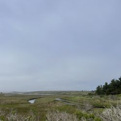
**EXPLORING NEW TRAIL** Estero Trailhead to Sunset Beach Trail Length: About 8 miles RT Level: Moderate Time: Depends on how fast you go. It took us almost 4 hours RT with stops for photos/videos and snacks at Sunset Beach. Parking: Yes. At Estero Trailhead (Medium Size lot) Restroom: At Estero Trailhead (2 Restrooms) Take photos/videos but Leave NO Trace. Estero Trailhead to Sunset Beach is such a beautiful long hike with varying scenery. Nice ocean view along the trail. We passed by lots of grazing cattle and about 3 cow gates. We saw some deer, snakes, birds, crabs, cow patties and even seals. It gets really windy in the afternoon, so don't forget your windbreaker/jacket. Bring plenty of water, too and soak up the view.

Excellent hike! We did about 13 miles and it took us almost 6 hours. Very long but definitely worth it. Lots of wildlife. We saw a rubber Boa, an American badger, lots of birds, seals, otters, crabs, and of course some cows. The tide was low so we had a chance to see some ocean life including starfish. Bring lots of water and a hat, there is not that much shade. Amazing beach at the end where you can take a break and have some lunch. Some of the trails are not well marked so pay attention to the navigator, we use AllTrails app for that. Definitely one of my favorite hikes!

Estero Trail (ET) is my current favorite at Point Reyes. We researched our trip before we got there and wanted to hike it during our short time there. It turned out to be even better than I thought. It has amazing views of a lagoon, coastal foothills and ocean--there's even a bit through the forest before you get to a bridge at the inlet of Home Bay, the foot of the tidal lagoon. The destination is the secluded Sunset Beach and picnic site. ET is good for hikers and mountain bikers both. There are no blind turns and surprise encounters between bikers and hikers, and bikers yield to hikers on the trail. It's a 7.8-mile round trip, rated easy to moderate, with connector links available for longer rides for mountain bikers (a 12-mile route is the best according to others). We didn't make it all the way to Sunset Beach, unfortunately, but we would have if we'd at the time. Next time, Gadget! ET is a great place for bird watching as we encountered several different types: California Quail, Great Blue Heron, Grebes and Scoters. I can't wait to go back. Point Reyes is my favorite spot in the whole world.


This is GREAT trail. Start at Estero Trailhead-Estero trail-Sunset Beach trail. Official trail stops before the beach, but there is an unofficial trail reaches to Sunset beach. Nice ocean view along the trail. At the small bay during Estero Trail, you can observe birds, crabs, small fish. and all the way along the trail (Estero and Sunset), cows, rabbits, deer :)
")
We did the Estero Trail to Drakes Head hike (http://www.nps.gov/pore/planyourvisit/hiking_guide.htm) - I'd had knee surgery a couple months ago and this was a nice low key hike without too much elevation change but the reward of an AMAZING view at the end: http://www.yelp.com/biz_photos/estero-trail-point-reyes-station?select=hBsr6Ee-WmDWn19fIKtpMA#hBsr6Ee-WmDWn19fIKtpMA http://www.yelp.com/biz_photos/estero-trail-point-reyes-station?select=SAsR2xqYhz4cQdw2UHlscw#SAsR2xqYhz4cQdw2UHlscw http://www.yelp.com/biz_photos/estero-trail-point-reyes-station?select=SAsR2xqYhz4cQdw2UHlscw#SWU95fYCfEtLb6668tkVOA Most of the hike is through fields and is uncovered (with a brief walk through some woods at the start), plus some crossings over lagoons. There are a lot of grazing cows and at one point the trail merged with a cattle trail and we got off trail for about quarter of a mile before hitting a dead end. Grazing cattle: http://www.yelp.com/biz_photos/estero-trail-point-reyes-station?select=SAsR2xqYhz4cQdw2UHlscw#QbODkd4_VBvTkFxogzfmmQ Towards the end you are going down the peninsula and are surrounded by more and more water, and all of a sudden you're at the end with a steep drop-off in front of you: you get this amazing view of the Pacific, with sand bar spreading through the shallow aqua-blue water below you. We could see plenty of wildlife in the water and the air around us, and it was the perfect place to sit and eat lunch. It was the end of May, a beautiful weekend, and we only ran into one two other people on the trail - one mountain biker.

I've wanted to come here since reading about the leopard sharks and bat rays that congregate in Drakes Estero at certain times of the year. So when some friends organized a BBQ at Drakes Bay Oyster Farm (just a short drive past the trail), I took the opportunity to cross another place off my to-go list. The Estero Trail is 9 miles in all, and leads through grassland, forest, and marshes on the way to the water. Due to time constraints and the fact that we're trying to get back into shape, we only hiked 2 miles out. But even in that short distance, the scenery was beautiful and we saw plenty of wildlife. The portion of the trail we hiked was excellent for beginners--pretty much flat, with some easy hills. One of the steeper ascents gave us a panoramic perspective on one of the bay's inlets, which we witnessed at low tide. I loved how the pools of water looked like liquid fingers outstretched on the mudflats. At the crest of that same hill, there's a gate we passed through to continue on the trail. We stopped to rest on the cliff overlooking the bay, watching the sea birds dive into the water. After watching a few minutes more, I noticed there were dark shapes moving near the shore. Then I saw what looked like black dorsal fins breaking the water; whatever they were seemed to be swimming in pairs. Then I realized that it was single creature: a bat ray, whose undulating wings were cutting the water in tandem! Even at that great distance, the rays (suddenly I could see many of them) seemed big--maybe 4-5 feet across? What an amazing sight! I didn't think anything could surpass that perfect moment, but I was wrong. On the way back, a fellow hiker stood stock still on the trail, with camera raised. Sure enough, as we crept closer, we could see the deer he had his lens trained on. It seemed undisturbed by our presence, and we were able to watch it meander in the brush alongside the trail. Estero Trail is probably deserving of 5 stars for its natural beauty, but I'll save that for when I conquer the entire trail--and maybe get a close-up look at a bat ray.

This hike was definitely worth the hour drive from San Rafael. We did the Sunset Beach Trail which was 8-8.5 miles total. It wasn't difficult at all. The beach however isn't an actual beach full of sand. The shore is completely covered in rocks but it's worth trekking through to see amazing views. We also saw seals, otters, deer, hares and even a snake along the hike. During low tide, the estuary will look empty but you'll see several crabs along the shoreline.

Did the roughly seven mile trail segment out to Sunset Beach and really enjoyed it. After descending a bit down a hill through some trees, you spend most of the hike ascending and hiking along a ridge that tracks the shoreline. Great views of the estero and beyond, though be aware its mainly exposed with little shade. Passing through the cattle gates is a fun twist as you'll often get a close encounter of the bovine-kind. My only issue (and it's a small one) is that this specific trail isn't a loop (though you could easily make one by joining up a few other trails).

I can hear this past Saturday around 11:20 am with 3 other friends and it took about 4 hours to do 10 miles. There's some incline but nothing crazy. I forgot the trail name but it led to a beach which was very secluded and nice. There weren't many people hiking but a ton of mosquitoes. Don't forget to wear repellent. No fee for parking. read more


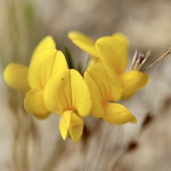
I love coming out here because it's more remote with lots of wildflowers, birds, and cattle grazing on the hills. The parking lot to the trail has bathrooms and a picnic bench. I'd recommend using both before the hike as there are no bathrooms on the trail nor a good place to sit for lunch along the way. For the first mile the trail is shaded and goes through a forest area until it hits a bridge at the estuary. From there it's open with views of the water and hills but no shade. Point Reyes is foggy most of the time even if it's sweltering in the rest of Marin but definitely bring layers and a hat because if you get a rare hot day this trail would be a lot more difficult with the absence of shade. It fluctuated in elevation, which was nice, but this made it more of a moderate as opposed to easy hike. There were a couple of ponds where birds would congregate so it's a great place for birder, I don't know all the kinds I saw but definitely some herons and California Quails. I also saw some elk grazing in the hills. At about 2.5 miles the trail forks and you can take the Sunset Trail or Drakes Head. The Sunset is a little shorter and at the end there's a bench to sit and look out. Altogether about 8 miles 3.5-4.5 hrs. depending on stops. read more


**EXPLORING NEW TRAIL** Estero Trailhead to Sunset Beach Trail Length: About 8 miles RT Level: Moderate Time: Depends on how fast you go. It took us almost 4 hours RT with stops for photos/videos and snacks at Sunset Beach. Parking: Yes. At Estero Trailhead (Medium Size lot) Restroom: At Estero Trailhead (2 Restrooms) Take photos/videos but Leave NO Trace. Estero Trailhead to Sunset Beach is such a beautiful long hike with varying scenery. Nice ocean view along the trail. We passed by lots of grazing cattle and about 3 cow gates. We saw some deer, snakes, birds, crabs, cow patties and even seals. It gets really windy in the afternoon, so don't forget your windbreaker/jacket. Bring plenty of water, too and soak up the view. read more


4 years ago
Excellent hike! We did about 13 miles and it took us almost 6 hours. Very long but definitely worth it. Lots of wildlife. We saw a rubber Boa, an American badger, lots of birds, seals, otters, crabs, and of course some cows. The tide was low so we had a chance to see some ocean life including starfish. Bring lots of water and a hat, there is not that much shade. Amazing beach at the end where you can take a break and have some lunch. Some of the trails are not well marked so pay attention to the navigator, we use AllTrails app for that. Definitely one of my favorite hikes! read more


9 years ago
Estero Trail (ET) is my current favorite at Point Reyes. We researched our trip before we got there and wanted to hike it during our short time there. It turned out to be even better than I thought. It has amazing views of a lagoon, coastal foothills and ocean--there's even a bit through the forest before you get to a bridge at the inlet of Home Bay, the foot of the tidal lagoon. The destination is the secluded Sunset Beach and picnic site. ET is good for hikers and mountain bikers both. There are no blind turns and surprise encounters between bikers and hikers, and bikers yield to hikers on the trail. It's a 7.8-mile round trip, rated easy to moderate, with connector links available for longer rides for mountain bikers (a 12-mile route is the best according to others). We didn't make it all the way to Sunset Beach, unfortunately, but we would have if we'd at the time. Next time, Gadget! ET is a great place for bird watching as we encountered several different types: California Quail, Great Blue Heron, Grebes and Scoters. I can't wait to go back. Point Reyes is my favorite spot in the whole world. read more


One of my favorite trails! You see lush green fields and bodies of water before the ocean. An easy 8 mile hike where we saw snakes, cows, deer, crabs, and seals! It ends at a nice beach where you can take in the view while eating lunch. read more


This is GREAT trail. Start at Estero Trailhead-Estero trail-Sunset Beach trail. Official trail stops before the beach, but there is an unofficial trail reaches to Sunset beach. Nice ocean view along the trail. At the small bay during Estero Trail, you can observe birds, crabs, small fish. and all the way along the trail (Estero and Sunset), cows, rabbits, deer :) read more


We did the Estero Trail to Drakes Head hike (http://www.nps.gov/pore/planyourvisit/hiking_guide.htm) - I'd had knee surgery a couple months ago and this was a nice low key hike without too much elevation change but the reward of an AMAZING view at the end: http://www.yelp.com/biz_photos/estero-trail-point-reyes-station?select=hBsr6Ee-WmDWn19fIKtpMA#hBsr6Ee-WmDWn19fIKtpMA http://www.yelp.com/biz_photos/estero-trail-point-reyes-station?select=SAsR2xqYhz4cQdw2UHlscw#SAsR2xqYhz4cQdw2UHlscw http://www.yelp.com/biz_photos/estero-trail-point-reyes-station?select=SAsR2xqYhz4cQdw2UHlscw#SWU95fYCfEtLb6668tkVOA Most of the hike is through fields and is uncovered (with a brief walk through some woods at the start), plus some crossings over lagoons. There are a lot of grazing cows and at one point the trail merged with a cattle trail and we got off trail for about quarter of a mile before hitting a dead end. Grazing cattle: http://www.yelp.com/biz_photos/estero-trail-point-reyes-station?select=SAsR2xqYhz4cQdw2UHlscw#QbODkd4_VBvTkFxogzfmmQ Towards the end you are going down the peninsula and are surrounded by more and more water, and all of a sudden you're at the end with a steep drop-off in front of you: you get this amazing view of the Pacific, with sand bar spreading through the shallow aqua-blue water below you. We could see plenty of wildlife in the water and the air around us, and it was the perfect place to sit and eat lunch. It was the end of May, a beautiful weekend, and we only ran into one two other people on the trail - one mountain biker. read more
 - Hiking Near Me - Point Reyes Station, California")
 - Hiking Near Me - Point Reyes Station, California")
 - Hiking Near Me - Point Reyes Station, California")
 - Hiking Near Me - Point Reyes Station, California")
I've wanted to come here since reading about the leopard sharks and bat rays that congregate in Drakes Estero at certain times of the year. So when some friends organized a BBQ at Drakes Bay Oyster Farm (just a short drive past the trail), I took the opportunity to cross another place off my to-go list. The Estero Trail is 9 miles in all, and leads through grassland, forest, and marshes on the way to the water. Due to time constraints and the fact that we're trying to get back into shape, we only hiked 2 miles out. But even in that short distance, the scenery was beautiful and we saw plenty of wildlife. The portion of the trail we hiked was excellent for beginners--pretty much flat, with some easy hills. One of the steeper ascents gave us a panoramic perspective on one of the bay's inlets, which we witnessed at low tide. I loved how the pools of water looked like liquid fingers outstretched on the mudflats. At the crest of that same hill, there's a gate we passed through to continue on the trail. We stopped to rest on the cliff overlooking the bay, watching the sea birds dive into the water. After watching a few minutes more, I noticed there were dark shapes moving near the shore. Then I saw what looked like black dorsal fins breaking the water; whatever they were seemed to be swimming in pairs. Then I realized that it was single creature: a bat ray, whose undulating wings were cutting the water in tandem! Even at that great distance, the rays (suddenly I could see many of them) seemed big--maybe 4-5 feet across? What an amazing sight! I didn't think anything could surpass that perfect moment, but I was wrong. On the way back, a fellow hiker stood stock still on the trail, with camera raised. Sure enough, as we crept closer, we could see the deer he had his lens trained on. It seemed undisturbed by our presence, and we were able to watch it meander in the brush alongside the trail. Estero Trail is probably deserving of 5 stars for its natural beauty, but I'll save that for when I conquer the entire trail--and maybe get a close-up look at a bat ray. read more


This hike was definitely worth the hour drive from San Rafael. We did the Sunset Beach Trail which was 8-8.5 miles total. It wasn't difficult at all. The beach however isn't an actual beach full of sand. The shore is completely covered in rocks but it's worth trekking through to see amazing views. We also saw seals, otters, deer, hares and even a snake along the hike. During low tide, the estuary will look empty but you'll see several crabs along the shoreline. read more


Did the roughly seven mile trail segment out to Sunset Beach and really enjoyed it. After descending a bit down a hill through some trees, you spend most of the hike ascending and hiking along a ridge that tracks the shoreline. Great views of the estero and beyond, though be aware its mainly exposed with little shade. Passing through the cattle gates is a fun twist as you'll often get a close encounter of the bovine-kind. My only issue (and it's a small one) is that this specific trail isn't a loop (though you could easily make one by joining up a few other trails). read more


9 years ago
Such a beautiful hike of varying scenery. When you turn off the main road, you may wonder if you're going the right way, but press on and you'll find the free parking lot (mind the very large cows along the way!). Your hike will begin in green rolling hills before shortly entering the forest. We had a windy day after rains, for which I'd recommend ankle galoshes, not sneakers, as the forrest trail got quite muddy. Exit the forrest to marsh, where we saw deer running and a sea otter playing under the bridge. Once you cross to the other side, the hike turns from an easy stroll to a moderately difficult up hill climb. It doesn't take too long to reach great views of the inlet of the bay. read more


11 years ago
11 years ago
More info about Estero Trail
Sir Francis Drake Blvd
Point Reyes Station, CA 94956
Directions
Hours
Outdoor Amenities
Ask the Community - Estero Trail
Review Highlights - Estero Trail


Estero Trail - hiking - Updated June 2026
Best of Point Reyes Station
People found Estero Trail by searching for…
Beaches in Point Reyes Station, California
Tide Pools in Point Reyes Station, California
Things to Do in Point Reyes Station, California
Hiking Trails in Point Reyes Station, California
Picnic Spots in Point Reyes Station, California
Easy Hikes in Point Reyes Station, California
Watch Sunset in Point Reyes Station, California
Picnic Areas in Point Reyes Station, California
Fishing in Point Reyes Station, California
Off Road Trails in Point Reyes Station, California
Swimming in Point Reyes Station, California
Trails in Point Reyes Station, California
Sunset View in Point Reyes Station, California
Walking Trails in Point Reyes Station, California
Redwood Forest in Point Reyes Station, California
View Points in Point Reyes Station, California
Beaches for Kids in Point Reyes Station, California
Running Trails in Point Reyes Station, California
Crab Fishing in Point Reyes Station, California
Picnic Food in Point Reyes Station, California
Scenic View in Point Reyes Station, California
Playground in Point Reyes Station, California
Trending Searches in Point Reyes Station, CA
Black Owned Nail Salons near Estero Trail
Cliff Jumping near Estero Trail
Dog Friendly Trails near Estero Trail
Fishing Spots near Estero Trail
Jet Ski Rental near Estero Trail
Kayak Rental near Estero Trail
Lakes & Ponds near Estero Trail
Off Road Trails near Estero Trail
Outdoor Activities near Estero Trail
Places To Walk Around near Estero Trail
Public Pools near Estero Trail
Public Shower near Estero Trail
River Swimming near Estero Trail
Scenic Night View near Estero Trail
Scenic Overlook near Estero Trail
Secluded Spots near Estero Trail
Soccer Store near Estero Trail
Strawberry Picking near Estero Trail
Sunrise View near Estero Trail
Swimming Holes near Estero Trail
Swimming Lakes near Estero Trail
U Pick Farms near Estero Trail
Browse Articles
Browse Nearby
BEST of Point Reyes Station, California Restaurants near Estero Trail
BEST of Point Reyes Station, California Coffee near Estero Trail
BEST of Point Reyes Station, California Things to Do near Estero Trail
BEST of Point Reyes Station, California Beaches near Estero Trail
BEST of Point Reyes Station, California Breakfast near Estero Trail
BEST of Point Reyes Station, California Wineries near Estero Trail
BEST of Point Reyes Station, California Campgrounds near Estero Trail
Browse Brands
Related Searches in Point Reyes Station, CA
Affordable Kayak Rental Services in Point Reyes Station, California
Best Fishing Locations and Guides in Point Reyes Station, California
Best Nature Trails for Hiking in Point Reyes Station, California
Best Places for Horseback Riding in Point Reyes Station, California
Check Out Off Road Trails in Point Reyes Station, California
Discover Dog Friendly Trails to Explore in Point Reyes Station, California
Discover Scenic Hiking Trails in Point Reyes Station, California
Discover Scenic Mountain Bike Trails Near Point Reyes Station, California
Discover Scenic Waterfall Spots in Point Reyes Station, California
Discover Top Nature Parks to Visit in Point Reyes Station, California
Discover a Hiking Trail in Point Reyes Station, California
Discover the Best Night Hike Trails in Point Reyes Station, California
Discover the Best Running Track in Point Reyes Station, California
Dog-Friendly Hikes With Dogs in Point Reyes Station, California
Enjoy Camping Adventures Around Point Reyes Station, California
Enjoy Exciting Mountain Biking Adventures in Point Reyes Station, California
Enjoy Kayaking Adventures in Point Reyes Station, California
Enjoy Tent Camping Spots Around Point Reyes Station, California
Enjoy a Beautiful Waterfall Hike in Point Reyes Station, California
Enjoy the Best Picnic Spots and Ideas in Point Reyes Station, California
Enjoy the Best Walking Path in Point Reyes Station, California
Enjoy the Best Walking Trails in Point Reyes Station, California
Exciting Cliff Jumping Spots in Point Reyes Station, California
Experience Thrilling White Water Rafting in Point Reyes Station, California
Explore Beautiful Parks and Green Spaces in Point Reyes Station, California
Explore Easy Hikes Perfect for All in Point Reyes Station, California
Explore Fun Activities to Do in Point Reyes Station, California
Explore Popular Campgrounds Near Point Reyes Station, California
Explore the Best Beach Spots in Point Reyes Station, California
Explore the Best Swimming Holes Around Point Reyes Station, California
Explore the Best Trail Options in Point Reyes Station, California
Family Friendly Hiking With Kids in Point Reyes Station, California
Find Beautiful Views in Point Reyes Station, California
Find the Best Parks for Picnics in Point Reyes Station, California
Great Places to Walk in Point Reyes Station, California
Hiking Trails With Waterfalls in Point Reyes Station, California
Off Leash Dog Hiking Trails in Point Reyes Station, California
Plan a Scenic Drive Route Near Point Reyes Station, California
Popular Outdoor Activities to Try in Point Reyes Station, California
Popular Picnic Spots to Visit in Point Reyes Station, California
Safe and Fun Parks for Kids in Point Reyes Station, California
Top Climbing Spots and Gyms in Point Reyes Station, California
Top Paddleboarding Activities in Point Reyes Station, California
Top Places for Snorkeling in Point Reyes Station, California
Top Running Trails to Explore in Point Reyes Station, California
Top Swimming Lakes to Enjoy in Point Reyes Station, California
Top Swimming Spots and Pools in Point Reyes Station, California
Top Things to Do With Kids in Point Reyes Station, California
Walk Dog Friendly Hiking Trails in Point Reyes Station, California
Walk the Best Paved Walking Trails in Point Reyes Station, California
People who viewed Estero Trail also viewed
Tomales Point Trail - Tule Elk Preserve
135 reviews
Rodeo Valley Trail
6 reviews
Lobos Creek Valley Trail at the Presidio
8 reviews
Presidio
Tennessee Valley
203 reviews
Immigrant Point/Coastal Connector Trail aka 1,000 Step Trail
10 reviews
Presidio
Point Reyes National Seashore
407 reviews
Sky Trail
3 reviews
Steep Ravine Trail
48 reviews
Morse's Gulch Falls
5 reviews
Bull Point Trail
5 reviews