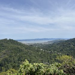
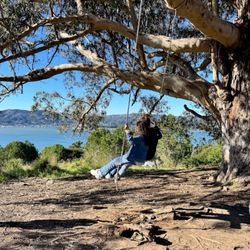
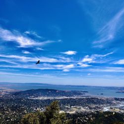
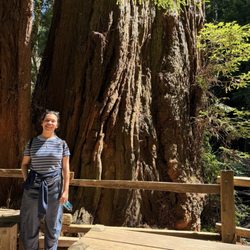
Dipsea Photos

 - Hiking Near Me")


You might also consider
More like Dipsea
Recommended Reviews - Dipsea
Start your review...

Reviews With Photos

Dipsea Trail is a must-hike if you're an avid hiker and in the Bay Area! It has ocean views, rolling hills, deep forest, waterfalls, babbling brooks and more. The route we took, our total hike was around 8.0 miles with gorgeous views the whole way. We hiked Dipsea to Steep Ravine to Matt Davis and it took us around 3-3.5 hours using the AllTrails map below. The first 5+ miles were all uphill but under the shade of the trees. I'm a huge dog lover and love hiking with my dog but I want to share this. Dogs are NOT allowed on the trail. There is a ladder you have to go up/down (depending on your route) and we saw a group holding up a bunch of other hikers figuring out how to get their 50lb+ dog down. Dogs also aren't allowed to protect the trail and plants. I would definitely do this hike again and bring out of town friends to join too! Check out this trail on AllTrails. https://www.alltrails.com/trail/us/california/dipsea-trail-to-steep-ravine-trail-to-matt-davis-loop-trail

I did this trail as a part of the Matt Davis and Steep Ravine Loop. Honestly one of the best hikes! You'll go through a forest of trees, stream, waterfall, and ocean views. It's a pretty popular hiking destination so make sure to wear a mask! We came across a few hikers who didn't have masks on :( Parking is limited so come early!

This immediately became my favorite hike, considering I don't even hike that often, which I honestly don't know why, but I had a wonderful time hiking this beautiful trail. I came with a group of TWELVE and we started around 12pm near Stinson Beach, so we went uphill first (leg day - YAY!). Majority of the hike is through the forest filled with tall redwood trees, small waterfalls and streams, and many many many steep and uneven stairs. We definitely took our time and took several breaks. The hike wasn't too difficult for me and I'm pretty glad I managed to keep all 12 people together without losing anyone. It's definitely strenuous but sooo worth. I really would like to come back and go for another round this summer. Highly recommend! :)

Hands down one of my favorite things about Marin. I've done the Dipsea trail multiple times but I do the stairs almost daily. It is especially fun to do the stairs after heavy rain as you will see water gushing down the first set of steps like a little waterfall under the stairs :). Once you reach the top you are greeted by a wonderful vista of oak woodland habitat of which a hiking trail runs right through. You can also hang a right and connect with the Dipsea trail from there. On some evenings you will encounter a blanket of chilling fog and wind on Molino after finishing your trek up the stairs. What an absolute gift after building heat and raising your heart rate on the way up. A lot of folks use the stairs to boost their VO2 max for big hikes and will ascend multiple times with weighted vests on. I've been this person before and it is great for that purpose.

Completed this thru-hike from Muir Woods to Stinson Beach on 9/17/2021. The trail is approx. 6 miles (one way), with an elevation gain of +1400. The weather was perfect for this hike, overcast with a little sunshine peeking through throughout the hike..so beautiful. I can't begin to articulate the beauty of this trail and the peace it brought me. Pictures posted, do NOT do any justice!! If you decide to start in Muir Woods you will be required to pay for parking and an entrance fee. If you have an annual pass, you will not require to pay the entrance fee. This hike is strenuous on the knees, use trekking poles for the last 3 miles of the trail, as you descend into Stinson Beach. The grade is -8.1%. Dress in layers, bring lunch/snacks, plenty of H2O. The takeaway, if you decide to do this thru-hike: 1. Make sure you have a ride back from Stinson Beach to Muir Woods. You will not be able to get an UBER or Lyft. There is an individual who will take you back to your car if needed. Their information is at the end of the Trail and charges 20$ for the group. But, I'm not sure if he's still active. 2. Spotty cell service throughout the hike. 3. Dress in layers. 4. Take your time going down the "stairs from hell". 5. Enjoy the scenery and take lots of pictures.

This trail leads to Stinson beach with total hike of about 14 miles from the trailhead . Very nice trail parking has to be on street within the white line marked on the streets surrounding trail head. Depsea trail head begins with stairs. Shaded stair trail that leads to mountains rainforest with birds chirping n California wild flowers. 3 miles in trail leads to Muir Woods with 700 ft elevations After that another 4 miles leads to Stinson beach with elevation of 1700 ft. Overall good trail carry lots of water and no restrooms along the trail. We just did half a trail and plan to do other half some other day.

This was a beautiful hike. The beautiful redwoods and just breathtaking scenery. You will want to start early for sure. Once the fog blows through the sun will make it's presence felt. Definitely bring lots of water and sunscreen. We started at the Muir Woods forest and journeyed our way to the Dipsea trail towards Stinson beach. We ended up doing more than 9.7 miles....we actually hiked over 11 miles. Once you get to Stinson beach you will come across a cafe. You can take a little break and have a little snack. It's a long and strenuous hike so be prepared for some soreness....especially when you head back to Muir Woods. We are for the most part experienced hikers and we felt the burn. It's definitely a good challenge. It's pretty close to a Mt. Diablo challenge. We will definitely do this trail again. FYI....you will need to go online and pay for your parking reservation for Muir Woods. We had purchase our reservation a week in advance and when we arrived they already had a sign saying the parking was full. So you will want to reserve at least a week in advance. Good luck and enjoy!

I love the view of this place. I came here with my friends and it was our first time hiking here. I thought it was very nice. The hike level is between intermediate and difficult. Beware: lots of stairs. Going down was nice, but you have to be very careful as their stairs are not even. Going up is a WHOLE different story. We went a whole round and we took a different route to get back to the parking lot. When we were going up the hill, I would say its about 10-15 mins non stop stairs going up. Don't get me wrong, I love stairs, but when you kept going up non stop and not even, it's a bit difficult for me. I had to stop few times to take a break. but the view totally worth it and I was so proud of myself. I would come back here during summer as its pretty shaded areas.

Had such an amazing time getting in the views- there are plenty of hiking aficionados you'll encounter but not in a way that feels like the trail is crowded. Rather, it was such a nice escape from campus and the business of the work week. It was also a great idea that we had a decent-sized group- any more than 6 people and we may have been too spread out. Would recommend bringing lunch and definitely water, if not some electrolytes too. It ended up being about a seven mile hike, with plenty of elevation gain and variety in the plants and vegetation. Try to have snacks that are very portable and easily consumed that also have a little bit of water content- carrot coins and cucumber slices are my go-to snacks. Also good to bring some protein items to keep your fuel up!

One of the best -- and best maintained -- rugged trails in Marin. There are three sections to the 7.5 mile trail from Mill Valley to Stinson Beach. The first section starts at Old Mill Park and goes up 700 stairs, another half mile up roads and then a mile down trail and steps to Muir Woods. The second section is all uphill, all trail and increasingly pretty as you climb 2 miles from Muir Woods to Cardiac near Pan Toll ranger station. The third section is all doooooooownhill through Steep Ravine and it's windy stairs, then out of the trees down to Stinson. About 3 miles. The views of the Pacific from Cardiac on down are incredible. The poison oak from Muir Woods to Stinson can be aggressive. You can take the West Marin Stagecoach from Stinson back to Mill Valley for $2. It runs every hours or less, so wise to check the schedule online.

We did a roughly 7 mile circuit of Dipsea/Steep Ravine/Matt Davis, starting and ending in Stinson Beach. Moderately challenging hike with very varied scenery along the way so never a boring moment. Compared to east coast trails most of the trail surface's quite even and not very rocky. At about 2/3 of the way we stopped on a hilltop to rest and have lunch - and get a good view of the skyline of San Francisco. Closer to the end there was another smaller lookout for a view of the town of Stinson Beach. The trails are all well maintained and marked and there are longer and shorter variations suitable for all levels and abilities.

The Dipsea Trail may be the most famous trail you've never heard of. It's the location of an annual footrace that is to Marin County what the Bay To Breakers is to San Francisco. It's Marin all the way. I lived in San Rafael for three years in my 20s, and although I'd heard about the Dipsea Trail, I never went on it. It's 7 miles long, and if I do the entire trail, how do I get back to the car? Now here I am, age 29, har har, and I've gone to the top of Half Dome and down in only one day; that's twice the distance of Dipsea. I've also conquered Mission Peak. I'd put the Dipsea as being harder than Mission Peak, and going back and forth on the Dipsea as being harder than Half Dome. Half of Mission Peak is downhill, letting your body weight carry you down, but you exert yourself for all 7 miles on the Dipsea. And you can kill yourself on Half Dome, but you'll wish you were dead if you attempt an out-and-back on the Dipsea. So, on a late September afternoon, I walked from Mill Valley to Stinson Beach on the famous trail. Here's what you've got: Three staircases, for a total of 674 steps. These 674 steps are part of a relentless uphill for 1-1/2 miles. (GET A MAP FIRST, there are few to no indicators of where you should turn at the top of each staircase.) It's fun dropping down into Muir Woods, and the trail is well marked from now on. But then starts a 2-1/2 mile uphill called Cardiac Hill, with a few flats but mostly a long haul to the highest point. It's mostly downhill from there, but part of that is a steep, dangerous staircase that probably sees a lot of injuries on race day. Then the trail insults you with yet another steep uphill; that's its name, Insult Hill. The last mile is a glorious downhill, with Stinson Beach in view, the sun beating down on your back, as you drop down to the Pacific Coast Highway. Interested yet? (3/4 of you are saying "no".) The good news is that, if you time it right, you park at Stinson, Golden Gate Transit's Route 61 takes you from there to Tam High, and from that point, you can either walk down Miller Ave. or take the #4 downtown. And the long hike takes you through a representative of every landscape in Marin County: fancy houses in the woods, open hills with shrubberies, redwoods and pines, and a cool ocean breeze. That's why I wrote that it's Marin all the way. You can get these same experiences without the agonizing effort, but adding the challenge of completing this monster makes it a real thrill. How did I do it? Well, remembering Philippians 4:13 helped, "I can do all things through Christ who strengthens me". Especially where there's no civilization and no cell phone reception. So here I am, my 100th review in 2016, making it count. If you want a physical challenge, try this one.

Mt. Tamalpais provides so many hiking trails that you can hike every weekend during a calendar year and not hit the same trail. You can access Dipsea Trail from anywhere along Mt. Tam, and you can even hit it from Muir Woods. During our hike, we opted to start near Stinson Beach and hit the beach after our hike for a quick picnic. On this particular day, during our drive to our meeting location, I was getting dizzy and felt like throwing up. Maybe it was because I woke up too early that day and did not have anything to eat, but I was feeling lousy. During the winding road up hill, I literally had to stop the vehicle as I was pretty sure I was going to vomit on the side of the road. It didn't happen and by fortuitous chance, the other vehicle that we met on the way down and stopped behind us actually belonged to our hiking party, my cousin's family to be exact. We convoyed to the meeting place and I was seriously questioning if I was going to continue or just wait in the car until I recovered from my dizziness. They told me to toughen it up and the fresh air will do me good. Like a trooper, I gathered myself and willed every ounce of energy I had at that time to join the group. Of course I stayed behind the pack as I slowly began to recover. Indeed, after several minutes of hiking straight uphill, I did begin to recover and the effects of the dizziness began to dissipate after each and every step I took. Once we got in the canopy of the trees, I was feeling a lot better and began to enjoy the scenery around me. This trail will kick your behind, but in a good way. Never have I encountered a trail that provides so many scenery changes and terrain changes that you have to be on your toes. One minute your under the sun in the wide open, the next minute your under the shade of the Redwoods smelling the fresh air. There's also a stream of cool, refreshing water that I could not help but had to douse myself with. Trust me, it felt like a jolt of energy that gave me the boost to go on. The top provides an awesome view of the Bay, and I could even see Daly City and beyond from where I was standing. Like I mentioned, there are so many trails to choose from once you get to a destination point and decide to head back that either trail you take will give you the same challenge of navigating your way back while providing you with wonderful scenery. It's definitely a trail I would like to return to again and explore more of what it has to offer. Mother Nature is so friggin awesome!

 - Hiking Near Me")
I finally made it to this trail! I used to live & work in Mill Valley (years ago) & never made it to this hike. We started at the beautiful Old Mill Park (where I used to take my niece & nephew when they were little). As mentioned in other reviews there are lots & lots of steps! Great cardio & leg strengthening. The views are so worth it and the trip back was super quick bring all downhill. Many other options of hiking trails to take from here which I like. read more


One word; STAIRS! Lots of stairs. And inclines galore. The hike along the Dipsea trail is definitely not for the faint of heart. It's a strenuous trek that maneuvers through some of the most beautiful parts of Mount Tamalpais and Muir Woods. The great thing is, you can combine this trail with other trails within the park to make it as easy or as strenuous as you'd like. One of the most popular variations of this hike is the Dipsea-Matt Davis-Steep Ravine loop trail. It's roughly 8 miles and 1,700 feet of elevation gain, and tackles parts of the Dipsea stairs and Matt Davis trail inclines. I hiked this loop and it was absolutely fabulous! The Dipsea portion of the hike is mainly exposed but offers some really scenic coastal views when you reach the top. Compared to the Matt Davis and Steep Ravine Trail, it was my least favorite, but I still enjoyed the workout that I got from hiking up the stairs. The Dipsea trail is definitely more of an incline workout versus a super scenic trek. But when combining this trail with other more scenic trails in the park, you'll be able to enjoy the best of both worlds. The Dipsea Trail can actually be accessed from a few different locations within the park. The three most popular access points are from Stinson Beach, Pantoll Campground, and Muir Woods National Monument. I started on the trail from Stinson Beach and I really enjoyed the loop through Steep Ravine and Matt Davis. Would recommend if you're looking for a versatile hike in Marin with a mix of stairs, ocean views, and forested pathways. read more


Dipsea Trail is a must-hike if you're an avid hiker and in the Bay Area! It has ocean views, rolling hills, deep forest, waterfalls, babbling brooks and more. The route we took, our total hike was around 8.0 miles with gorgeous views the whole way. We hiked Dipsea to Steep Ravine to Matt Davis and it took us around 3-3.5 hours using the AllTrails map below. The first 5+ miles were all uphill but under the shade of the trees. I'm a huge dog lover and love hiking with my dog but I want to share this. Dogs are NOT allowed on the trail. There is a ladder you have to go up/down (depending on your route) and we saw a group holding up a bunch of other hikers figuring out how to get their 50lb+ dog down. Dogs also aren't allowed to protect the trail and plants. I would definitely do this hike again and bring out of town friends to join too! Check out this trail on AllTrails. https://www.alltrails.com/trail/us/california/dipsea-trail-to-steep-ravine-trail-to-matt-davis-loop-trail read more


I did this trail as a part of the Matt Davis and Steep Ravine Loop. Honestly one of the best hikes! You'll go through a forest of trees, stream, waterfall, and ocean views. It's a pretty popular hiking destination so make sure to wear a mask! We came across a few hikers who didn't have masks on :( Parking is limited so come early! read more

This immediately became my favorite hike, considering I don't even hike that often, which I honestly don't know why, but I had a wonderful time hiking this beautiful trail. I came with a group of TWELVE and we started around 12pm near Stinson Beach, so we went uphill first (leg day - YAY!). Majority of the hike is through the forest filled with tall redwood trees, small waterfalls and streams, and many many many steep and uneven stairs. We definitely took our time and took several breaks. The hike wasn't too difficult for me and I'm pretty glad I managed to keep all 12 people together without losing anyone. It's definitely strenuous but sooo worth. I really would like to come back and go for another round this summer. Highly recommend! :) read more

 - Hiking Near Me")


4 years ago
Hands down one of my favorite things about Marin. I've done the Dipsea trail multiple times but I do the stairs almost daily. It is especially fun to do the stairs after heavy rain as you will see water gushing down the first set of steps like a little waterfall under the stairs :). Once you reach the top you are greeted by a wonderful vista of oak woodland habitat of which a hiking trail runs right through. You can also hang a right and connect with the Dipsea trail from there. On some evenings you will encounter a blanket of chilling fog and wind on Molino after finishing your trek up the stairs. What an absolute gift after building heat and raising your heart rate on the way up. A lot of folks use the stairs to boost their VO2 max for big hikes and will ascend multiple times with weighted vests on. I've been this person before and it is great for that purpose. read more


4 years ago
Completed this thru-hike from Muir Woods to Stinson Beach on 9/17/2021. The trail is approx. 6 miles (one way), with an elevation gain of +1400. The weather was perfect for this hike, overcast with a little sunshine peeking through throughout the hike..so beautiful. I can't begin to articulate the beauty of this trail and the peace it brought me. Pictures posted, do NOT do any justice!! If you decide to start in Muir Woods you will be required to pay for parking and an entrance fee. If you have an annual pass, you will not require to pay the entrance fee. This hike is strenuous on the knees, use trekking poles for the last 3 miles of the trail, as you descend into Stinson Beach. The grade is -8.1%. Dress in layers, bring lunch/snacks, plenty of H2O. The takeaway, if you decide to do this thru-hike: 1. Make sure you have a ride back from Stinson Beach to Muir Woods. You will not be able to get an UBER or Lyft. There is an individual who will take you back to your car if needed. Their information is at the end of the Trail and charges 20$ for the group. But, I'm not sure if he's still active. 2. Spotty cell service throughout the hike. 3. Dress in layers. 4. Take your time going down the "stairs from hell". 5. Enjoy the scenery and take lots of pictures. read more


5 years ago
This trail leads to Stinson beach with total hike of about 14 miles from the trailhead . Very nice trail parking has to be on street within the white line marked on the streets surrounding trail head. Depsea trail head begins with stairs. Shaded stair trail that leads to mountains rainforest with birds chirping n California wild flowers. 3 miles in trail leads to Muir Woods with 700 ft elevations After that another 4 miles leads to Stinson beach with elevation of 1700 ft. Overall good trail carry lots of water and no restrooms along the trail. We just did half a trail and plan to do other half some other day. read more


This was a beautiful hike. The beautiful redwoods and just breathtaking scenery. You will want to start early for sure. Once the fog blows through the sun will make it's presence felt. Definitely bring lots of water and sunscreen. We started at the Muir Woods forest and journeyed our way to the Dipsea trail towards Stinson beach. We ended up doing more than 9.7 miles....we actually hiked over 11 miles. Once you get to Stinson beach you will come across a cafe. You can take a little break and have a little snack. It's a long and strenuous hike so be prepared for some soreness....especially when you head back to Muir Woods. We are for the most part experienced hikers and we felt the burn. It's definitely a good challenge. It's pretty close to a Mt. Diablo challenge. We will definitely do this trail again. FYI....you will need to go online and pay for your parking reservation for Muir Woods. We had purchase our reservation a week in advance and when we arrived they already had a sign saying the parking was full. So you will want to reserve at least a week in advance. Good luck and enjoy! read more


8 years ago
I love the view of this place. I came here with my friends and it was our first time hiking here. I thought it was very nice. The hike level is between intermediate and difficult. Beware: lots of stairs. Going down was nice, but you have to be very careful as their stairs are not even. Going up is a WHOLE different story. We went a whole round and we took a different route to get back to the parking lot. When we were going up the hill, I would say its about 10-15 mins non stop stairs going up. Don't get me wrong, I love stairs, but when you kept going up non stop and not even, it's a bit difficult for me. I had to stop few times to take a break. but the view totally worth it and I was so proud of myself. I would come back here during summer as its pretty shaded areas. read more


Had such an amazing time getting in the views- there are plenty of hiking aficionados you'll encounter but not in a way that feels like the trail is crowded. Rather, it was such a nice escape from campus and the business of the work week. It was also a great idea that we had a decent-sized group- any more than 6 people and we may have been too spread out. Would recommend bringing lunch and definitely water, if not some electrolytes too. It ended up being about a seven mile hike, with plenty of elevation gain and variety in the plants and vegetation. Try to have snacks that are very portable and easily consumed that also have a little bit of water content- carrot coins and cucumber slices are my go-to snacks. Also good to bring some protein items to keep your fuel up! read more


One of the best -- and best maintained -- rugged trails in Marin. There are three sections to the 7.5 mile trail from Mill Valley to Stinson Beach. The first section starts at Old Mill Park and goes up 700 stairs, another half mile up roads and then a mile down trail and steps to Muir Woods. The second section is all uphill, all trail and increasingly pretty as you climb 2 miles from Muir Woods to Cardiac near Pan Toll ranger station. The third section is all doooooooownhill through Steep Ravine and it's windy stairs, then out of the trees down to Stinson. About 3 miles. The views of the Pacific from Cardiac on down are incredible. The poison oak from Muir Woods to Stinson can be aggressive. You can take the West Marin Stagecoach from Stinson back to Mill Valley for $2. It runs every hours or less, so wise to check the schedule online. read more


We did a roughly 7 mile circuit of Dipsea/Steep Ravine/Matt Davis, starting and ending in Stinson Beach. Moderately challenging hike with very varied scenery along the way so never a boring moment. Compared to east coast trails most of the trail surface's quite even and not very rocky. At about 2/3 of the way we stopped on a hilltop to rest and have lunch - and get a good view of the skyline of San Francisco. Closer to the end there was another smaller lookout for a view of the town of Stinson Beach. The trails are all well maintained and marked and there are longer and shorter variations suitable for all levels and abilities. read more


The Dipsea Trail may be the most famous trail you've never heard of. It's the location of an annual footrace that is to Marin County what the Bay To Breakers is to San Francisco. It's Marin all the way. I lived in San Rafael for three years in my 20s, and although I'd heard about the Dipsea Trail, I never went on it. It's 7 miles long, and if I do the entire trail, how do I get back to the car? Now here I am, age 29, har har, and I've gone to the top of Half Dome and down in only one day; that's twice the distance of Dipsea. I've also conquered Mission Peak. I'd put the Dipsea as being harder than Mission Peak, and going back and forth on the Dipsea as being harder than Half Dome. Half of Mission Peak is downhill, letting your body weight carry you down, but you exert yourself for all 7 miles on the Dipsea. And you can kill yourself on Half Dome, but you'll wish you were dead if you attempt an out-and-back on the Dipsea. So, on a late September afternoon, I walked from Mill Valley to Stinson Beach on the famous trail. Here's what you've got: Three staircases, for a total of 674 steps. These 674 steps are part of a relentless uphill for 1-1/2 miles. (GET A MAP FIRST, there are few to no indicators of where you should turn at the top of each staircase.) It's fun dropping down into Muir Woods, and the trail is well marked from now on. But then starts a 2-1/2 mile uphill called Cardiac Hill, with a few flats but mostly a long haul to the highest point. It's mostly downhill from there, but part of that is a steep, dangerous staircase that probably sees a lot of injuries on race day. Then the trail insults you with yet another steep uphill; that's its name, Insult Hill. The last mile is a glorious downhill, with Stinson Beach in view, the sun beating down on your back, as you drop down to the Pacific Coast Highway. Interested yet? (3/4 of you are saying "no".) The good news is that, if you time it right, you park at Stinson, Golden Gate Transit's Route 61 takes you from there to Tam High, and from that point, you can either walk down Miller Ave. or take the #4 downtown. And the long hike takes you through a representative of every landscape in Marin County: fancy houses in the woods, open hills with shrubberies, redwoods and pines, and a cool ocean breeze. That's why I wrote that it's Marin all the way. You can get these same experiences without the agonizing effort, but adding the challenge of completing this monster makes it a real thrill. How did I do it? Well, remembering Philippians 4:13 helped, "I can do all things through Christ who strengthens me". Especially where there's no civilization and no cell phone reception. So here I am, my 100th review in 2016, making it count. If you want a physical challenge, try this one. read more


3 years ago
Mt. Tamalpais provides so many hiking trails that you can hike every weekend during a calendar year and not hit the same trail. You can access Dipsea Trail from anywhere along Mt. Tam, and you can even hit it from Muir Woods. During our hike, we opted to start near Stinson Beach and hit the beach after our hike for a quick picnic. On this particular day, during our drive to our meeting location, I was getting dizzy and felt like throwing up. Maybe it was because I woke up too early that day and did not have anything to eat, but I was feeling lousy. During the winding road up hill, I literally had to stop the vehicle as I was pretty sure I was going to vomit on the side of the road. It didn't happen and by fortuitous chance, the other vehicle that we met on the way down and stopped behind us actually belonged to our hiking party, my cousin's family to be exact. We convoyed to the meeting place and I was seriously questioning if I was going to continue or just wait in the car until I recovered from my dizziness. They told me to toughen it up and the fresh air will do me good. Like a trooper, I gathered myself and willed every ounce of energy I had at that time to join the group. Of course I stayed behind the pack as I slowly began to recover. Indeed, after several minutes of hiking straight uphill, I did begin to recover and the effects of the dizziness began to dissipate after each and every step I took. Once we got in the canopy of the trees, I was feeling a lot better and began to enjoy the scenery around me. This trail will kick your behind, but in a good way. Never have I encountered a trail that provides so many scenery changes and terrain changes that you have to be on your toes. One minute your under the sun in the wide open, the next minute your under the shade of the Redwoods smelling the fresh air. There's also a stream of cool, refreshing water that I could not help but had to douse myself with. Trust me, it felt like a jolt of energy that gave me the boost to go on. The top provides an awesome view of the Bay, and I could even see Daly City and beyond from where I was standing. Like I mentioned, there are so many trails to choose from once you get to a destination point and decide to head back that either trail you take will give you the same challenge of navigating your way back while providing you with wonderful scenery. It's definitely a trail I would like to return to again and explore more of what it has to offer. Mother Nature is so friggin awesome! read more


11 years ago
Talk about stair master!! Look out glutes, Dip Sea Trail is coming to burn you!! This is a fun little treasure hunt in Mill Valley, my friends and I had a mighty good workout making our way through this trail toward Nature's Friends Tourist Club. Once at the top, there are gorgeous views of the Valley and if you look way into the horizon, you'll see the ocean. read more


Dipsea is a spectacular trail that goes down to Stinson Beach. It's the perfect place for a weekend adventure. This trail is unique in that it takes you down to the little town by the beach which is lined with restaurants on both sides of the street. This means you have plenty of options for where to refuel, and there are several cafes with outdoor seating - some even have live music! We opted for Breakers Cafe and loved it. Parking is easy; you can park along the street or in one of the main lots. The trail also connects to several others, so you can just do Dipsea to/from the beach or connect to one of the others and make it a super long hike. (I've done the Dipsea / Steep Ravine / Matt Davis hike before and highly recommend it.) Great outdoors, great company, great scenery, and some great food & drinks in between. I'm a fan. read more


*Corrected Location* One of our annual hikes, once again, the entire loop is NOT for the "casual hiker." We went in a group of 17, most are advanced hikers (I am somewhere between.) This trail is definitely one of the most visually stimulating, climbing down to the beach can be tricky if you don't know what you are doing, or are too busy taking selfies of yourself eating while doing so! I definitely worked my legs on this trip, but the views and the reward are SPECTACULAR! Grateful to have been a hiker my entire life, and to be adopted by one of the funnest, and most challenging Nor Cal hiking groups! read more

One of best trail I've ever been to! We came on a perfect day when the weather was temperate and the creeks was rustling. Everything was vibrant green thanks to the week long rain. Easily one of the most beautiful trail in the bay area. We parked at Pantoll Campground and hike down through Steep Ravine Trail to Dipsea Trail. Easy trail to follow. There's a lot of kids hiking with their parents. The view's amazing that would distract you from the long hike. It took us 3 hrs and something to get to Stinson Beach! We ended up at Parks Cafe by the beach and rewarded ourselves with a cone of ice cream. We took the shuttle back to the campground where we parked. $2 for the shuttle. I suggest, park at Stinson Beach and take the shuttle to Pantoll to start your hike so you don't need to wait for the shuttle when you're done hiking. The shuttle schedule is long in between. read more


I dedicate my 500th review to getting my ass kicked. But first... When I first started using Yelp in 2006, I never thought it would lead me to discover places in my own backyard. I saw it more as forum which sanctioned my occasional bad punning, love of food, and wanderlust. In retrospect, I think I've found so many of my favorite places and people via yelp, and it's contributed to a merriment of memory making. The Dipsea is probably the crown jewel of my Yelp finds. Last year I used the 'Send to a Friend' button to send the Dipsea page to my friend, which had been reviewed by someone I follow. To quote my friend in the response, "Dang! Looks like a challenge." Yeaaa, boy. I've now traversed this 14.8 mile round-trip trail a handful of times, loving each step, with its hills affectionately pet named 'Insult', 'Suicide', and 'Cardiac'. The ascents and descents literally keep you on your toes, all advancing you towards Stinson Beach, the light at the end. The trail is literally breathtaking, and for first timers there's no need to beat yourself up for huffing and puffing. Even those completely toned Greek statues who run on the trail all day must have started out struggling for air...maybe. The reprieve at Stinson is breathtaking in other ways, and the perfect place to recharge while taking in the endless horizon. Those stairs that begin and end the trail can sometimes be the smooch of death, but you'll appreciate the newly formed muscle cells in your glutes and quads a few days later, not to mention the pound you'll likely shed sweating. The views overlooking the coastline as you get to the moory part of the trail-with about a mile or mile and a half to go-are some of the most beautiful and majestic I've ever seen. All of the pain and literal heartache is worth it when you see these picture postcard worthy sweeping views. I'm nowhere close to being able to run this trail, but for a ass busting hike, it's just my speed. read more


Make sure you get a map at the ranger station before heading out. It really isn't that hard to get lost if you pay attention, but I'm a little directionally challenged. IE; I managed to start my hike backwards, so I actually went down the stairs as opposed to up like everyone complained about. Regardless, the hike was like no other. You're so deep into the redwoods you feel like you're in another world. I could have stayed out there all day if I had the time. read more


Hi. Hi there. Hello. I am becoming more familiar with the vernacular of the hike. My hiking pal and I did the first portion of this trail where it meets Muir Woods in early January and it's the *original stair master*, some 680+ stairs, 3 flights. Take your time and bring appropriate hiking gear including hiking sticks, sturdy shoes, hat, layers, and a light backpack of water & food. Sunscreen too. Sometimes passersby behind you (and those coming from the opposite direction) are faster, so I'd often step aside and let them pass. That's when I noticed the quick hi, hi there, hello, etc., courtesy greetings between hikers/runners. It's kinda nice. You might read up about this historic foot race which will reach age 102 this June: http://www.dipsea.org/. It provides history but also photos along the hike, if you're interested. My legs were jello by the end of staircase 2 but I made it to the top and beyond that day. Totally worth the work out; the view of the blg Blue is fantastic. An Epsom salt bath afterwards will help take the edge off sore legs. read more


13 years ago
11 years ago
This hike is just stunning, nonetheless, intense! Found out about this hike through a recommendation to my father awhile back. Finally made the trip over the weekend. RECOMMENDATION! I wish someone had mentioned this to me beforehand... the Dipsea Trail is a little more than 3 miles uphill hike starting at the parking lot of Muir Woods entrance, which has a beautiful view of the ocean at the very top. However, we wanted to get to Stinson Beach, an additional 3 miles, total of about 7miles ONE WAY. We felt great but then it struck us, we needed to hike 7miles back. So I started asking other hikers on how ppl do this hike, they literally said you have to bring 2 cars, and have one park at the end point to then head over the starting point. Don't get me wrong the hike is doable with time, first, we were kinda in a rush. Secondly, I had a friend with me who has a bad back, so after so many stairs and uphill hiking she was in pain. The others responded by saying yes, that's how ppl do the Dipsea Trail if they don't intend on hiking forth and back. So take two cars if 14miles is beyond your capability. Mainly up hill the first 3 miles and plenty of stairs heading into Stinson Beach. So stay hydrated, take some snacks to fuel along the way. A definite must hike if you're a california resident and even more if you're bay area resident. Next time, we plan on starting at Stinson Beach, hiking up to the top and then head back, a good 6mi hike instead, a bit more reasonable for us who love to do this on occasion. Happy Hiking! #lovetheBay read more


12 years ago
Went in for the hike on a Sunday morning. With a couple of us including me being rookie hikers, it took us around 4.5 hours to finish the trail. Started with a flight of steps at the old mill park, but lost our way a bit after that. That could account for the long 4.5 hours ;). Thanks to google maps and Verizon's good reception! It helped. The trail itself was really pretty and refreshing. The end of the trail opens out to the Stinson beach but if you don't plan it well you might not be able to spend time here as the shuttle 61 that takes you back to the starting point comes in only once in 2 hours. Overall well worth a trip! read more

Good trail, good views, and good signs! The signs were really clear about which way the Dipsea trail is. Partway up is a great view for sunset, and the paths are nicely paved and wide for people to walk. It gets a bit dusty though, so be careful. Some sloping, but in general not too bad. There's a section with a lot of stairs that's pretty strenuous though, and when we went, there was a tree blocking a section of the path so we had to climb over it. In general very nice though; most of it is shaded except for the beginning part, and after the ocean view there are many trees. Good path to try if you want a challenge! read more


17 years ago
And so, it was once again time for yours truly to don his pantry and mini trama center onto his back...for yet another fun filled hike. A group of us made plans to hike at The Dipsea Trail yesterday, which turned out to be a moderate "plus" hike due to the awesome steep inclines. In short, The Dipsea Trail is an historic route between Mill Valley and Stinson Beach. There is about 2,200 feet of vertical ascent and descent on the route as well as many, many stair steps! Yes...three words come to mind..."feel the burn"!!! We hiked from Stinson Beach (across Panoramic Highway) onto The Dipsea Trail in which the first part is laden with mossy Oak and Baywoodland, the trail breaks out into grasslands, introducing panoramic views of San Francisco to the south and Point Reyes to the north (coolio). Once exposed to this wondrous panoramic view, we spent time taking in the scenery while drinking water, nibbling on some munchies, as it was an uphill battle that led us to this point. We needed to re energise our legs which had pounded against the steep climb from the trail head to this point (stepped and without steps). So if you are going, be sure to pack some yummy snacks; cookies, dried fruite, and what not as you will definately need the feul. The pleasantness of this trail is awesome, in addition to the views, the trails are littered with the scent of Pine and Douglasfur being blown by the coastal winds. After the much needed break at the grasslands; with food, water, carrots, chocolate chip cookies, dried mangos, and yes...even chocolate soy milk, we trekked along The Dipsea Trail onto the Muir Woods Visitors Center...4.5 miles in total. On our return, we decided to take The Dipsea Trail back, with one minor shortcut; we veered onto The Deer Park Fire Road (which runs parallel to The Dipsea Trail, yet several feet above). We were greeted by Douglas Fur and much older growth Red Woods, where among the grass and wooded lands (and one big boulder) we once again enjoyed food and drinks. After our break, we moved along The Deer Park Fire Road, and finally merged back onto The Dipsea Trail...finishing our adventure with a relaxing time on the sand in the Beach by sitting/laying down...enjoying the sounds of the waves, the chirping of those annoying seagulls (staring out our food with their beaty little eyes). Our return trip proved to be a shorter journey as it turned out to be only 4 miles (although hilly as it was above The Dipsea Trail). In all, we hiked a total of 8.5 miles or approximately 14 kilometers with about 2,200 feet of vertical ascent and descent. Mind you, The Dipsea trail is longer, so you have an option to hike into Muir Woods or to even start from there. Seriously, who the hell needs the stair climber at the gym when we've got these awesome trails? :-p I am rating this place a four as bathrooms are located only at the trail heads, however, this is the outdoors...so...well...one can always use the shrubs and what not. While letting nature flow through you, when out in nature, be carefull to stay away from the three leafed shrubbery as it is mostly likely poison oak. There's alot of poison oak on the trails, so, if you are taking little Johhny, little Jane, or the family dog, be watchfull. read more


Another nice weekend in between stretches of rainy weekdays meant getting out of the house & heading for the hills. Out around Muir Woods, the girlfriend wanted to find an old fave of hers that she hadn't been to in years, the Dipsea Trail. From Muir Woods, the trail goes up constantly to a high enough altitude to get some great views of the wooded hills, valleys & the Pacific. It's a good enough climb to let you know that you really did do some hiking but not so tough to be utterly debilitating. Fresh air & exercise in the great outdoors with beautiful views, the Dipsea Trail's got that. read more

This isn't as easy as some say and it's also not as difficult but it is strenuous its up,up,up then down,down,down then up,up,up again. Through redwood forests and clear trails with great views of SF. Many different flowers that you don't see except up there.It wasn't easy finding a place to park, set out earlier rather than later.I'm very glad I did it we made it under 4 hrs there was some sort of a detour I don't know if it made it longer or shorter. Wear comfy clothes and shoes, bring water. I didn't see ant bathroom facilities, so keep that in mind. Unless you want to hike back have a car on either end or get the bus schedule. The bus ride goes up and down also so if you don't get a seat it gave the term "strap hanger" a whole new meaning :) read more


11 years ago
Dipsea trail is no joke! Definitely a workout. We started the trail closest to the parking lot near the entrance to the Redwood National Monument. And my thighs, hamstrings, and calves can all vouch for me when I say that its a constant uphill battle. Maybe its a fitness thing - Since I'm not fit at all - that I was struggling. But that's what's so great about it. I wanted that work out and I got it! You're taken through another mystical forest first and are brought to an open area without the convenience of trees for shade. I'm not sure how long that lasts because we only hiked about 2 miles out, but I plan to return and hopefully finish the trail! read more


10 years ago
***Update*** One time wasn't enough to so we decided to hike this trail again on May 29, 2016. This was our 2nd time hiking the Dipsea Trail from Mill Valley. We arrived an hour earlier that we did last year and began the hike around 6AM. The marine layer was thick and constant, giving us chills as we approach the mist. I was reminded again of why I love this hike so much, particularly the "rain forest." And as usual, we celebrated the hike with some major grub and brew at the Siren Canteen, followed by a short power nap on Stinson beach with our shoes kicked off and listening to the waves. Go check it out (and check out new photos from our recent hike). read more


Awesome hike. Especially if you love rolling grassland hills. And the best part is the end when you come back down to stinson beach, it's just beautiful. It's not particularly easy or short, but it's also totally doable. A lot of up hill. and then downhill! Only downside: hard to find parking. Good luck! read more


Page 1 of 3
More info about Dipsea
Mill Valley, CA 94942
Directions
Visit Website
http://www.dipsea.org/
Hours
Outdoor Amenities
Ask the Community - Dipsea
Are dogs allowed on this trail?
Most sections allow dogs, especially the 800 steps in Mill Valley. There's some sections that have a no dogs sign, but we saw a couple walk their dog on that section past a ranger, and he didn't say anything to them.
Review Highlights - Dipsea
You might also consider


Why does Yelp recommend reviews?
9 reviews that are not currently recommended
The reviews below are not factored into the business's overall star rating.
14 years ago
9 years ago
4 years ago
15 years ago
12 years ago
14 years ago
11 years ago
Dipsea - hiking - Updated June 2026
Best of Mill Valley
People found Dipsea by searching for…
Things to Do in Mill Valley, CA
Hiking Trails in Mill Valley, CA
Waterfall Hike in Mill Valley, CA
Dog Friendly Hiking Trails in Mill Valley, CA
Scenic View in Mill Valley, CA
Campgrounds in Mill Valley, CA
Stairs Workout in Mill Valley, CA
Walking Trails in Mill Valley, CA
Redwood Trees in Mill Valley, CA
Abandoned Buildings in Mill Valley, CA
Playgrounds in Mill Valley, CA
Secret Spots in Mill Valley, CA
Beautiful Views in Mill Valley, CA
Running Trails in Mill Valley, CA
Swimming Lakes in Mill Valley, CA
Hiking Club in Mill Valley, CA
Watch Sunset in Mill Valley, CA
Attractions in Mill Valley, CA
Trending Searches in Mill Valley, CA
Browse Articles
Browse Nearby
BEST of Mill Valley, California Walking Trails near Dipsea
BEST of Mill Valley, California Coffee near Dipsea
BEST of Mill Valley, California Restaurants near Dipsea
BEST of Mill Valley, California Things to Do near Dipsea
BEST of Mill Valley, California Breakfast near Dipsea
BEST of Mill Valley, California Parks near Dipsea
BEST of Mill Valley, California Hot Springs near Dipsea
Browse Brands
Related Searches in Mill Valley, CA
Affordable Kayak Rental Services in Mill Valley, California
Best Fishing Locations and Guides in Mill Valley, California
Best Nature Trails for Hiking in Mill Valley, California
Best Places for Horseback Riding in Mill Valley, California
Check Out Off Road Trails in Mill Valley, California
Discover Dog Friendly Trails to Explore in Mill Valley, California
Discover Kid Friendly Hiking Trails in Mill Valley, California
Discover Scenic Hiking Trails in Mill Valley, California
Discover Scenic Mountain Bike Trails Near Mill Valley, California
Discover Scenic Waterfall Spots in Mill Valley, California
Discover Top Nature Parks to Visit in Mill Valley, California
Discover Walking Parks in Mill Valley, California Near You
Discover a Hiking Trail in Mill Valley, California
Discover the Best Night Hike Trails in Mill Valley, California
Discover the Best Running Track in Mill Valley, California
Dog-Friendly Hikes With Dogs in Mill Valley, California
Enjoy Camping Adventures Around Mill Valley, California
Enjoy Kayaking Adventures in Mill Valley, California
Enjoy Tent Camping Spots Around Mill Valley, California
Enjoy a Beautiful Waterfall Hike in Mill Valley, California
Enjoy the Best Picnic Spots and Ideas in Mill Valley, California
Enjoy the Best Walking Path in Mill Valley, California
Enjoy the Best Walking Trails in Mill Valley, California
Exciting Cliff Jumping Spots in Mill Valley, California
Explore Beautiful Parks and Green Spaces in Mill Valley, California
Explore Easy Hikes Perfect for All in Mill Valley, California
Explore Fun Activities to Do in Mill Valley, California
Explore Popular Campgrounds Near Mill Valley, California
Explore the Best Beach Spots in Mill Valley, California
Explore the Best Swimming Holes Around Mill Valley, California
Explore the Best Trail Options in Mill Valley, California
Family Friendly Hiking With Kids in Mill Valley, California
Find Beautiful Views in Mill Valley, California
Find the Best Parks for Picnics in Mill Valley, California
Find the Best Scenic View Locations in Mill Valley, California
Great Places to Walk in Mill Valley, California
Hike the Popular Waterfall Trail in Mill Valley, California
Hiking Trails With Waterfalls in Mill Valley, California
Off Leash Dog Hiking Trails in Mill Valley, California
Plan a Scenic Drive Route Near Mill Valley, California
Popular Outdoor Activities to Try in Mill Valley, California
Popular Picnic Spots to Visit in Mill Valley, California
Safe River Swimming Areas in Mill Valley, California
Safe and Fun Parks for Kids in Mill Valley, California
Top Climbing Spots and Gyms in Mill Valley, California
Top Running Trails to Explore in Mill Valley, California
Top Swimming Lakes to Enjoy in Mill Valley, California
Top Swimming Spots and Pools in Mill Valley, California
Walk Dog Friendly Hiking Trails in Mill Valley, California
Walk the Best Paved Walking Trails in Mill Valley, California
People who viewed Dipsea also viewed
Tiburon Ridge Preserve
15 reviews
Slackers Hill
23 reviews
Hoo Koo E Koo Loop
8 reviews
Mount Tamalpais State Park
433 reviews
Cascade Park
4 reviews
Morning Sun Trail
4 reviews
Old St. Hilary's Open Space Nature Preserve
12 reviews
Muir Woods National Monument
1884 reviews
Baltimore Canyon
18 reviews
Indian Tree Preserve
14 reviews