Slackers Hill Photos


You might also consider
More like Slackers Hill
Recommended Reviews - Slackers Hill
Start your review...

Reviews With Photos

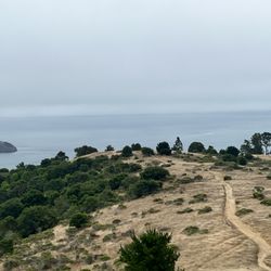
Come for the view, you can see for miles and miles on a clear day but don't get too disappointed if it's foggy because that happens a lot up here. You can see Mount Tam, Mount Diablo, Angel Island, the city, etc. in the distance. The hike is only a mile so good if you don't have a lot of time or don't want to do a full headlands hike. While short, the trail is a actually a bit steep. It doesn't look it at first but the incline was constant. I don't think it was too bad but I wouldn't recommend it for people that can't walk far or are looking for more of a walk than a hike. For that I think Hawk Hill is better because the walk up is easier. Parking for the shortest route is at Coastal Trail Parking but there are other trails that lead here too.

This hike does have a good amount of stairs. The views are beautiful. We came in Feb in the morning it was extremely windy and a little foggy. If you start in Sausalito you can park at the park and ride. We saw horses. People had dogs. Lots of runners. Good amount of mountain bikers. It took us about 2 hours. I would like to come back on a more clear day but it was still beautiful

I don't know if this hilltop was named after a military hero or if it describes the type of hiker who scales it. It looks like the type of expanse where you could hang out for hours on end under the influence of whatever you want. Other than the tippy-top of Twin Peaks, it's also one of the few places around the bay where you can get a 360-degree panoramic view of the bay without straining your neck. You just need to do a pirouette with your smartphone, and unlike Twin Peaks, you're not likely going to run into anybody else performing the same ballet move. That's because all the tourists are below at Battery Spencer getting a close-up of the Golden Gate Bridge (review: https://bit.ly/3Dgm43d). To get to this spot, you follow the same winding road you take to Battery Spencer, McCullough Road, until you hit the roundabout at Conzelman Road. Instead of veering left toward the bridge, you veer right and quickly turn into a small gravel parking lot with a restroom. The trail starts there and requires crossing McCullough to get to the beginning of the rocky ascent. It's a well-defined path, a bit of a climb but only half a mile to the flat hilltop. The views are great - though the Golden Gate Bridge is partially hidden by a lower hill in that direction. If you're more of a hiking fanatic, there are longer options like following the path alongside Conzelman Road from Battery Spencer or taking the SCA Trail from even lower in the hills. I prefer the shorter route as the hike was a more efficient use of time and not very taxing. If you prefer to be away from the crowds to get your panorama shots, this would be the place to do it, whether you're a slacker or not. RELATED - Up for a hike? Here's a collection of trails I've walked and reviewed: http://bit.ly/2OrC8nU


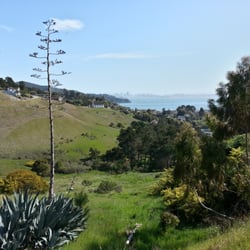
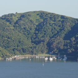
Easy short hike (walk?) from the parking lot to the top of the hill. Parking lot - limited parking space but a lot of road side parking available. Bathroom - At the parking lot. One stall. Smelly (normal). Toilet paper available. No water. Hike - 10 minutes one way. Up hill. Easy. View - Super awesome. You can see the whole downtown San Francisco. Both Bay Bridge and Golden Gate Bridge are visible. Tip - Make sure you pick a good clear day to visit. We came here once when it's foggy and you cannot see anything at all. Not even the GG Bridge!!!

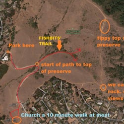
Heard a lot of good reviews about this hike, so of course visiting SF I needed to come try it. I came with my gf and friend and it was probably just our luck but we came up on the most foggiest day. We tried to park before the sun came out, but we had issues finding it because it was pitch black and supper foggy, so we ended up waiting until there was some light to look for where the hike was. To help others visiting of looking to do this hike I have posted some pictures to help you find the trail and parking. When we got to the top we couldn't see the spectacular view of the Golden Gate Bridge that everyone was posting and ranting about that's why I gave it a 4/5 star. The hike was nice and short. It took us about 15 minutes. Be warn, what everyone says about it being a killer steep hike. They are right. I workout regularly and my booty was burning! Hopefully I'll able to do this hike again and see/capture the view everyone has been posting.

This was a 6 mile trek and wasn't extremely easy. It's gets easy if you do have your trekking poles handy. We did see a coyote stand in the middle of nowhere and did hear it howl when approaching the bobcat trail. Karl the fog was all over and was quite windy and we had no view at all. Golden Gate Bridge was just not visible, will do this trail once again just for the view but I still had fun loosing some calories.


Amazing short little hike. Starts next to the outhouse. Beautiful views of the bridge and city (Karl the Fog allowing) above all the other tourists parking on the side of roads. Will be a tough incline if you're a true slacker or not in great shape. Totally doable if you take it slow, though, because it's just over a mile there and back.

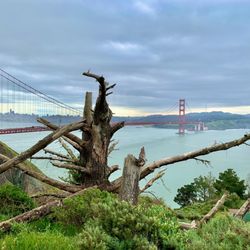
Beautiful views awarded to those that can hike less than 1 mile with a short, but moderately steep incline. Despite the trailhead being a stone's throw from one of the most heavily-visited tourist spots in the Bay Area (the Golden Gate Bridge overlook on Conzelman), the trails are usually almost empty and a short steep climb leads to a vantage point with exceptional views. From this trailhead you could make a 3 mile loop of the roadside path along Conzelman combined with Coastal Trail. Even though the roadside path abuts Conzelman, views to the Golden Gate should provide some compensation. Or take Coastal Trail to the west, drop down into Rodeo Valley and climb on Rodeo Valley Trail to SCA Trail. The return route passes over the Baker-Barry Tunnel before skirting Slacker Hill to the trailhead. This option is about 4.6 miles. The summit is gorgeous (and a bit spooky in the fog), but can be chilly, so dress accordingly. The gated fire road begins a sharp and rocky ascent -- look uphill to the right at the huge boulder hanging off the hillside. After climbing about 1/4 mile, you'll reach a signed junction. Turn right, following the sign to Slacker Ridge.


Steep, short climb to be above the clouds and Golden Gate You will be above the clouds and high on the mountaintops at the end of this hike. Dress for warmth as it's cold and windy up there even if it's sunny on your drive up. You will be panting at the top, but if you take it slow, anyone can do this hike. Take your time enjoying the view at the top! read more


Come for the view, you can see for miles and miles on a clear day but don't get too disappointed if it's foggy because that happens a lot up here. You can see Mount Tam, Mount Diablo, Angel Island, the city, etc. in the distance. The hike is only a mile so good if you don't have a lot of time or don't want to do a full headlands hike. While short, the trail is a actually a bit steep. It doesn't look it at first but the incline was constant. I don't think it was too bad but I wouldn't recommend it for people that can't walk far or are looking for more of a walk than a hike. For that I think Hawk Hill is better because the walk up is easier. Parking for the shortest route is at Coastal Trail Parking but there are other trails that lead here too. read more


1 year ago
This hike does have a good amount of stairs. The views are beautiful. We came in Feb in the morning it was extremely windy and a little foggy. If you start in Sausalito you can park at the park and ride. We saw horses. People had dogs. Lots of runners. Good amount of mountain bikers. It took us about 2 hours. I would like to come back on a more clear day but it was still beautiful read more


I don't know if this hilltop was named after a military hero or if it describes the type of hiker who scales it. It looks like the type of expanse where you could hang out for hours on end under the influence of whatever you want. Other than the tippy-top of Twin Peaks, it's also one of the few places around the bay where you can get a 360-degree panoramic view of the bay without straining your neck. You just need to do a pirouette with your smartphone, and unlike Twin Peaks, you're not likely going to run into anybody else performing the same ballet move. That's because all the tourists are below at Battery Spencer getting a close-up of the Golden Gate Bridge (review: https://bit.ly/3Dgm43d). To get to this spot, you follow the same winding road you take to Battery Spencer, McCullough Road, until you hit the roundabout at Conzelman Road. Instead of veering left toward the bridge, you veer right and quickly turn into a small gravel parking lot with a restroom. The trail starts there and requires crossing McCullough to get to the beginning of the rocky ascent. It's a well-defined path, a bit of a climb but only half a mile to the flat hilltop. The views are great - though the Golden Gate Bridge is partially hidden by a lower hill in that direction. If you're more of a hiking fanatic, there are longer options like following the path alongside Conzelman Road from Battery Spencer or taking the SCA Trail from even lower in the hills. I prefer the shorter route as the hike was a more efficient use of time and not very taxing. If you prefer to be away from the crowds to get your panorama shots, this would be the place to do it, whether you're a slacker or not. RELATED - Up for a hike? Here's a collection of trails I've walked and reviewed: http://bit.ly/2OrC8nU read more


Quick hike but definitely not for slackers!! It was so worth making it to the top and the beautiful views along the way. We were the only ones on the trail and enjoyed the cool breeze along the way and at the top. I highly recommend you check this out!! read more


4 years ago
Very very steep but view worth it. Our senior pups got tired so we didn't make it to the top but fabulous views of SF from the back read more

5 years ago
Easy short hike (walk?) from the parking lot to the top of the hill. Parking lot - limited parking space but a lot of road side parking available. Bathroom - At the parking lot. One stall. Smelly (normal). Toilet paper available. No water. Hike - 10 minutes one way. Up hill. Easy. View - Super awesome. You can see the whole downtown San Francisco. Both Bay Bridge and Golden Gate Bridge are visible. Tip - Make sure you pick a good clear day to visit. We came here once when it's foggy and you cannot see anything at all. Not even the GG Bridge!!! read more


Heard a lot of good reviews about this hike, so of course visiting SF I needed to come try it. I came with my gf and friend and it was probably just our luck but we came up on the most foggiest day. We tried to park before the sun came out, but we had issues finding it because it was pitch black and supper foggy, so we ended up waiting until there was some light to look for where the hike was. To help others visiting of looking to do this hike I have posted some pictures to help you find the trail and parking. When we got to the top we couldn't see the spectacular view of the Golden Gate Bridge that everyone was posting and ranting about that's why I gave it a 4/5 star. The hike was nice and short. It took us about 15 minutes. Be warn, what everyone says about it being a killer steep hike. They are right. I workout regularly and my booty was burning! Hopefully I'll able to do this hike again and see/capture the view everyone has been posting. read more


5 years ago
This was a 6 mile trek and wasn't extremely easy. It's gets easy if you do have your trekking poles handy. We did see a coyote stand in the middle of nowhere and did hear it howl when approaching the bobcat trail. Karl the fog was all over and was quite windy and we had no view at all. Golden Gate Bridge was just not visible, will do this trail once again just for the view but I still had fun loosing some calories. read more


4 years ago
BEWARE THE TICKS! Slackers Ridge Trail was definitely not for slackers. The .4 mile trek all uphill (31 floors) was no joke but the view was incredible. Biggest downside was the amount of ticks our dog picked up along the trail. We're still finding them hours later. read more


Amazing short little hike. Starts next to the outhouse. Beautiful views of the bridge and city (Karl the Fog allowing) above all the other tourists parking on the side of roads. Will be a tough incline if you're a true slacker or not in great shape. Totally doable if you take it slow, though, because it's just over a mile there and back. read more

4 years ago
Beautiful views awarded to those that can hike less than 1 mile with a short, but moderately steep incline. Despite the trailhead being a stone's throw from one of the most heavily-visited tourist spots in the Bay Area (the Golden Gate Bridge overlook on Conzelman), the trails are usually almost empty and a short steep climb leads to a vantage point with exceptional views. From this trailhead you could make a 3 mile loop of the roadside path along Conzelman combined with Coastal Trail. Even though the roadside path abuts Conzelman, views to the Golden Gate should provide some compensation. Or take Coastal Trail to the west, drop down into Rodeo Valley and climb on Rodeo Valley Trail to SCA Trail. The return route passes over the Baker-Barry Tunnel before skirting Slacker Hill to the trailhead. This option is about 4.6 miles. The summit is gorgeous (and a bit spooky in the fog), but can be chilly, so dress accordingly. The gated fire road begins a sharp and rocky ascent -- look uphill to the right at the huge boulder hanging off the hillside. After climbing about 1/4 mile, you'll reach a signed junction. Turn right, following the sign to Slacker Ridge. read more


7 years ago
This is a place I have gone to frequently... I love to see the sunrise... God's creation is so beautiful. read more

5 years ago
This hill is not for "slackers". It has a steep incline. Incredible panoramic views from the top. A short, must-see. We were the only ones there. Spent a few minutes getting cool, foggy pics of the Golden Gate. read more

8 years ago
4 years ago
8 years ago
9 years ago
11 years ago
More info about Slackers Hill
Coastal Trl
Sausalito, CA 94965
Directions
Hours
Outdoor Amenities
Ask the Community - Slackers Hill
Review Highlights - Slackers Hill
You might also consider


Slackers Hill - hiking - Updated June 2026
Best of Sausalito
People found Slackers Hill by searching for…
Hiking Trails in Sausalito, CA
Walking Trails in Sausalito, CA
Things to Do With Kids in Sausalito, CA
Beautiful Views in Sausalito, CA
Parks for Kids in Sausalito, CA
Running Trails in Sausalito, CA
Hiking With Kids in Sausalito, CA
Lookout Points in Sausalito, CA
Stairs Workout in Sausalito, CA
Trending Searches in Sausalito, CA
Black Owned Nail Salons near Slackers Hill
Boat Rental near Slackers Hill
Cliff Jumping near Slackers Hill
Fishing Spots near Slackers Hill
Free Kids Activities near Slackers Hill
Jet Ski Rental near Slackers Hill
Lakes & Ponds near Slackers Hill
Off Road Trails near Slackers Hill
Outdoor Activities near Slackers Hill
Pick Your Own Farms near Slackers Hill
Places To Walk Around near Slackers Hill
Public Shower near Slackers Hill
Rock Quarry near Slackers Hill
Scenic Drive near Slackers Hill
Scenic Night View near Slackers Hill
Secluded Spots near Slackers Hill
Soccer Store near Slackers Hill
Strawberry Picking near Slackers Hill
Sunrise View near Slackers Hill
Swimming Holes near Slackers Hill
Swimming Lakes near Slackers Hill
Swimming Pools near Slackers Hill
Watch Sunset near Slackers Hill
Browse Articles
Browse Nearby
BEST of Sausalito, California Things to Do near Slackers Hill
BEST of Sausalito, California Coffee near Slackers Hill
BEST of Sausalito, California Walking Trails near Slackers Hill
BEST of Sausalito, California Restaurants near Slackers Hill
BEST of Sausalito, California Parks near Slackers Hill
BEST of Sausalito, California Breakfast near Slackers Hill
BEST of Sausalito, California Campgrounds near Slackers Hill
BEST of Sausalito, California Sightseeing near Slackers Hill
Browse Brands
Related Searches in Sausalito, CA
Affordable Kayak Rental Services in Sausalito, California
Best Fishing Locations and Guides in Sausalito, California
Best Nature Trails for Hiking in Sausalito, California
Best Places for Horseback Riding in Sausalito, California
Best Waterfalls and Swimming Holes in Sausalito, California
Check Out Off Road Trails in Sausalito, California
Discover Dog Friendly Trails to Explore in Sausalito, California
Discover Kid Friendly Hiking Trails in Sausalito, California
Discover Scenic Hiking Trails in Sausalito, California
Discover Scenic Mountain Bike Trails Near Sausalito, California
Discover Scenic Waterfall Spots in Sausalito, California
Discover Walking Parks in Sausalito, California Near You
Discover a Hiking Trail in Sausalito, California
Discover the Best Night Hike Trails in Sausalito, California
Discover the Best Running Track in Sausalito, California
Dog-Friendly Hikes With Dogs in Sausalito, California
Enjoy Camping Adventures Around Sausalito, California
Enjoy Kayaking Adventures in Sausalito, California
Enjoy Tent Camping Spots Around Sausalito, California
Enjoy a Beautiful Waterfall Hike in Sausalito, California
Enjoy the Best Picnic Spots and Ideas in Sausalito, California
Enjoy the Best Walking Path in Sausalito, California
Enjoy the Best Walking Trails in Sausalito, California
Exciting Cliff Jumping Spots in Sausalito, California
Explore Beautiful Parks and Green Spaces in Sausalito, California
Explore Easy Hikes Perfect for All in Sausalito, California
Explore Fun Activities to Do in Sausalito, California
Explore Popular Campgrounds Near Sausalito, California
Explore the Best Beach Spots in Sausalito, California
Explore the Best Swimming Holes Around Sausalito, California
Explore the Best Trail Options in Sausalito, California
Family Friendly Hiking With Kids in Sausalito, California
Find Beautiful Views in Sausalito, California
Find the Best Parks for Picnics in Sausalito, California
Find the Best Scenic View Locations in Sausalito, California
Great Places to Walk in Sausalito, California
Hike the Popular Waterfall Trail in Sausalito, California
Hiking Trails With Waterfalls in Sausalito, California
Off Leash Dog Hiking Trails in Sausalito, California
Plan a Scenic Drive Route Near Sausalito, California
Popular Outdoor Activities to Try in Sausalito, California
Popular Picnic Spots to Visit in Sausalito, California
Safe River Swimming Areas in Sausalito, California
Safe and Fun Parks for Kids in Sausalito, California
Top Climbing Spots and Gyms in Sausalito, California
Top Running Trails to Explore in Sausalito, California
Top Swimming Lakes to Enjoy in Sausalito, California
Top Swimming Spots and Pools in Sausalito, California
People who viewed Slackers Hill also viewed
Dipsea
92 reviews
Batteries to Bluffs Trail
107 reviews
Presidio
Cataract Falls Trail
257 reviews
Mt. Tamalpais East Peak
97 reviews
Ring Mountain Preserve
56 reviews
King Mountain
8 reviews
Tiburon Uplands Natural Preserve
5 reviews
Fishbits' Trail
2 reviews
Fairfax Open Space Preserve
6 reviews
Lovers' Lane at the Presidio
82 reviews
Presidio Heights